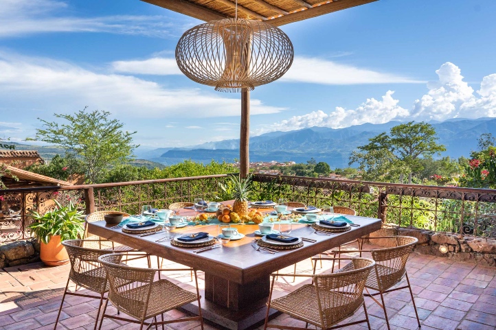
Barichara is on the list of Network of Colombian Heritage Villages, besides being one of the most beautiful villages nationwide thanks to its bohemian and colorful Andalusian style architecture.
Barichara is an excellent destination for a quiet place with a magical and photogenic atmosphere.
The town grow around the church built in 1751 on account of a supposed apparition of the Virgin. Initially it was called Vare – florence, then Vara-echada and finally Barichara, which means “Place for rest” in Guane dialect which is a derivative of Chibcha.
Barichara is built on stone. Its streets, houses, temples and especially the cemetery, a prominent place for its railings and windows, are built with yellow stone.
The cathedral of the Immaculate Conception in memory of the Virgin of the rock is a unique work, and the historic center of Barichara was declared a national monument on August 3, 1978.
In this guide you will have the necessary information to make the most of your visit in Barichara
The Diversity of Barichara
Barichara is a town in the northern Andes of Colombia with about 5,000 inhabitants. Approximately 90% of Barichara’s architecture is built by the tapia pisada technique, an ancestral procedure of building with earth, without the support of wooden pieces or any other material.
This town is located on a plateau of around 40,000-50,000 hectares, where historically there was a tropical dry forest, a type of threatened ecosystem that is in danger of disappearing from the Earth. Today, 98% of the forest is destroyed and urgently needs to be restored.
The Aquileo Parra Association – Friends of Barichara, is a non-profit organization that has the purpose of preserving the historical and touristic heritage of Barichara. It also defends the natural resources and the ecological reconstruction of the Tropical Dry Forest in the Bioparque Móncora project.
Temperatures in Barichara range between 19°C (66º F) and 28°C (82º F).
How to get to Barichara
Barichara locates in the department of Santander, 121 km from Bucaramanga capital of the department, and 350 km from Bogota, capital of Colombia.
To get to Barichara by air from the main cities of Colombia (Bogota, Barranquilla, Medellin or Cali) you must take a commercial flight to the city of Bucaramanga. Once in Bucaramanga, you take an approximately 3,5-hours ride to Barichara.
Where to stay in Barichara
Most of the hotels can be found in the historic center of town, where we recommend the following alternatives:
In the Villa del Alfarero you can experience the tradition of the typical construction of the village.
You will have a conversation where you will learn about the history and recommendations on the manufacturing process, besides having a tour of the village where you will be able to build a wall of Tapia from the time of preparation of the land to the assembly of the bricks made.
Bahareque
In this workshop you will learn about the millenary indigenous technique of Bahareque, through the oral tradition inherited from the indigenous Guanes tribe, inhabitants of this region.
During the workshop you will be taken on a tour of a real Bahareque construction and be able to touch its walls, caña brava, terrones, tree root ties, Fiquetones.
After having the theoretical knowledge of the technique you can put it into practice by building part of a wall.
At the end of the workshop you will take a bath, since you will be in contact with a lot of mud. So please bring along a pair of clean clothes.
Mud and adobe tile making
In the workshop you will be teach to identify 4 types of soil (Clay, Gredosa, Fine and Sandy) required for the elaboration of the tiles.
You will visit an ancestral oven with a production capacity of 4,000 units during 60 continuous hours of combustion, day and night, where temperatures reach over 1200 degrees Celsius.
You will get an explanation from the instructors of each of the steps in the production process where you can have a contact with the clay in each of the steps until you reach the firing point.
Typical cooking
In this workshop you will be able to have a direct contact with the typical gastronomy of Barichara. You will have the opportunity to learn about the production process of the following products and interact with the raw material: Typical Barichara cookies, “Arepas de maíz pelao” (corn), Pan artesanal, Sancocho de Gallina.
2. Visit the church and chapel of Barichara
Cathedral of the Immaculate Conception of Barichara.
You will see this beautiful and unusual 18th century Spanish colonial cathedral built entirely of yellow stone. Despite being a giant cathedral for the population of the town it is a place that will amaze you from the moment you enter and if you wait to see the sunset you will marvel at the beautiful ocher tone it takes at sunset.
This cathedral is a unique work, and it is supported by 10 monolithic columns carved with 5 meters high and 70 cm wide.
Visit the chapel of Santa Barbara
You want to know a beautiful chapel of the XVII century which is the scene of many marriages in the town due to its decoration with golden leaf, with arabesque, Moors and inverted flowers; which makes it a magical atmosphere for beautiful ceremonies. It is located 4 blocks from the main park of the town.
3. Visit the viewpoint of Barichara, the Salto del Mico.
Just 10 minutes walk from downtown you can enjoy a beautiful viewpoint where you will be able to appreciate the Suarez River Canyon, the Serrania de los Yariguies National Natural Park, and the municipalities of Galan, La Fuente and Zapatoca.
4. Visit the cemetery of Barichara
It is not usually one of the favorite plans of many people, but both the cemetery of Mompox and Barichara are considered one of the most beautiful in the country.
As well as all the construction of the town based on stone the cemetery is not the exception, during your tour inside the cemetery you will be able to appreciate beautiful stone carved tombstones and beautiful colonial structures.
5. Hiking Barichara – Cabrera
This tour is done through the road of Via crucis in the middle of a beautiful forest to reach the municipality of Cabrera; its duration is 6 hours with a medium degree of difficulty.
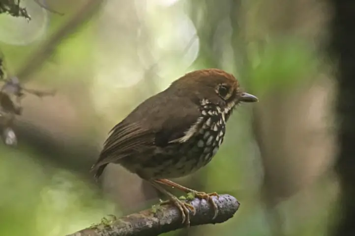
Besides, there you will be able to appreciate different types of butterflies and birds, among them you can have the possibility to see the Nicéforo’s wren (Thryophilus nicefori), an endemic bird species of Santander.
6. Tobacco Tour
It is important to know that the department of Santander is considered the largest producer of tobacco in Colombia with 50% of national production.
In the rural area of Barichara it is possible to find a farm where you can take a tour for 3 hours where you can see the different processes of development of the seedling (harvesting and maturation of tobacco).
7. Trekking in Barichara
You will have the opportunity to make a trekking in the middle of the fossils and the royal stone roads during three days, having as starting point Barichara to Los Yariguíes National Natural Park.
This tour should be done during three days, has a medium degree of difficulty and a total distance covered of approximately 40 km with an average daily walking time of 5 hours.
You can visit the village of Guane until you reach Zapatoca crossing the majestic Saravita river and the Lengerke II road. From Zapatoca you will make the last trip to Los Yariguíes National Natural Park.
8. Rafting Rio Suarez
This fantastic plan has a duration of 5 hours, has 8 fast currents with unique waves in the country; you will be enjoying one of the best rivers to develop this activity. Keep in mind that this activity can only be done by people over 18 years old.
9. Horseback riding
You can make horseback riding tours throughout the day, starting at 5:00 a.m. to appreciate the sunrise or at the last hour at 6:00 p.m.
The cobblestone streets and beautiful landscapes will accompany you on your tours and with the support of the guides you will learn more about this treasure of Colombia.
Thanks to the proximity between San Gil and Barichara of only 32 km you can choose to enjoy a full day of adventure activities that San Gil offers, and then at night return to Barichara.
From Bolivia to Namibia, there are few but enormous salt deserts in the world that can be visited, just as there are few salt mines in the world that open their doors to tourists. In Colombia you can find both, from sea level to the Andes mountains.
We invite you to take this tour through the salt deserts and salt mines of Colombia.
The Importance of Salt
The real value of salt, regardless of domestic consumption, which is marginal, lies in the fact that it is a fundamental input in at least a hundred industrial processes, ranging from the manufacture of balanced feed to detergents, glass and tannery treatment.
Colombia produces some 540,000 tons of salt annually, a relatively small figure. Forty percent of Colombia’s salt comes from the Zipaquirá, Nemocón, Upín and Galerazamba mines, while the remaining 60 percent is extracted from Manaure in La Guajira.
History of Salt Mines in Colombia
Origins of Salt Deposits in the Cretaceous Period
Salt deposits in the Andes are believed to have been left by ground movements during the Cretaceous, 200 million years ago, when the Eastern Cordillera was lifted, and large marine lakes were left to dry and sediment, until they were finally covered by a thick layer of earth.
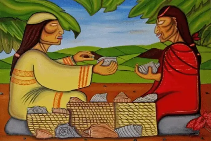
If there was one commodity that was prized by the indigenous people before the conquest, it was salt. This product was used in the barter system by the Muiscas.
Such was its value that salt allowed the creation of a network of roads and meeting places between indigenous markets where the product was exchanged for others such as corn, gold, ceramics or cotton. There was even a commercial relationship with coastal communities to exchange mine salt for sea salt.
The routes used by the Indians were around the Magdalena River, which connects the northern region of the country with the Muiscas in the Andes.
Salt was so important that for the Zipa and Zaque, the indigenous kings, territories such as Zipaquirá or Nemocón were the crown jewels and allowed them access to many luxuries that their geographical location denied them, including emeralds, fish and peacock feathers, among others.
Salt During the Spanish Colony
Later, salt became much more important among the Spaniards, who used it frequently, among other things, to preserve foodstuffs in the absence of refrigeration.
Salt During Colombia’s Independence
Later on, the income from the salt produced in Zipaquirá helped to finance the independence struggles. Salt was so important that during the 20’s of the last century, this activity was under the tutelage of the recently founded Bank of the Republic, as if it were the monetary policy of the time.
Recent History of Salt Mines in Colombia
In the 1970s, the salt monopoly remained in the hands of the state. Today the mines are managed by private industries.
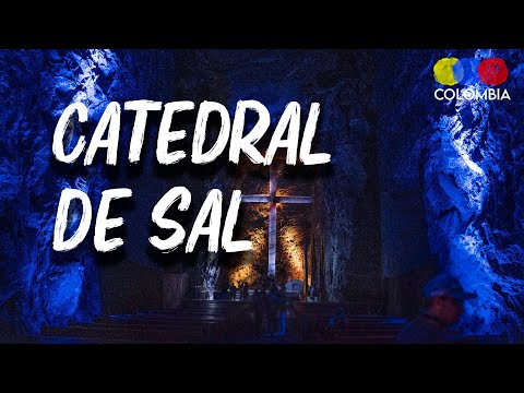
Apart from its economic importance, and its exploitation as a natural resource, today the salt mines and brines are important tourist destinations in Colombia, the most outstanding being the Salt Cathedral of Zipaquirá, Colombia’s first Wonder of the World.
So if you were wondering in which country is the Salt Cathedral, well here is your answer, it is in Colombia!
Marine Salt Mines of Colombia
An unforgettable visit to the pink seas and salt deserts of Colombia, a universe of landscapes and surreal beauty.
Manaure
The salt mine of Manaure is the department of La Guajira, in the Caribbean coast of Colombia. Manaure is the largest salt mine in Colombia, producing around 300,000 tons of salt per year. These mines are also an important part of the Wayuu indigenous people’s culture.
When you arrive at the salt mine of Manaure you will find an amazing salt desert. Besides, there is the big machinery pumping for the extraction of salt. Your guide will explain each of the salt extraction processes during the visit.
The main attraction of this maritime salt mine is the pink tone of its waters. This is due to the algae, small crustaceans and microorganisms which turn the water pink. Those amazing organisms are capable of withstanding these high levels of salinity.
At the end of the tour, you can go to the nearby beaches of Mayapo and El Pajaro. Both are quiet beaches with white sands and aquamarine green sea.
Take a 1-hour flight from El Dorado International Airport (BOG) Bogotá to Almirante Padilla International Airport (RCH) at Riohacha city. Once at the airport, take an approximately 1,5- hours (74 km) ride to Manaure.
Colombia’s Pink Sea: Galerazamba
The famous Pink Sea of Colombia is located in Galerazamba, Santa Catalina, department of Bolivar, between the cities of Cartagena and Barranquilla. It is 54 km from the city Cartagena and 67 km from the city of Barranquilla. It is an also located 15 min (4 km) from the famous Totumo volcano.
Galerazamba is known as “the pink sea of Colombia”. Like Manaure saline, it is pink. The color is given by the beta carotenes produced by a halophilic microalgae, i.e. salt lover microbes.
The mine opens Monday to Friday from 9:00 a.m. to 4:00 p.m. and on weekends the entrance starts at 8:00 a.m. The best time to visit this salt mine is in two seasons, one from December to April and the other from August to September.
How to get to Salina Galerazamba
Take a 1,5-hours flight from El Dorado (BOG) in Bogotá to Rafael Nuñez International Airport (CTG) at Cartagena city. Once at in Cartagena you take an approximately 1h30min ride (54 Km) to Salina Galerazamba.
Underground Salt Mines of Colombia
An unforgettable walk to the depths of the earth, descending through mining tunnels that support the mountain, you will know the most surprising corners of the Salt Mine, a universe of knowledge and sensations.
Nemocón Salt Mine
This beautiful salt mine is located near the municipality of Nemocón, in the department of Cundinamarca. The mine has more than 500 years of history underground and is considered a natural wonder thanks to its vernacular architecture, material testimony of the traditional subway mining. It opened its doors to the public 38 years ago.
The entrance door to the mine is a large German door 3 meters high, which is supported by thick trunks of eucalyptus. The eucalyptus trunks are still there because the salt filtered through the plant fibers. Then salt got solid and now the trunks are stronger than the rock.
Inside you will find the salt waterfall, more than 80 years old, and the spring or wishing well, which are some of their main scenarios. This is a magical thematic, mining, cultural, historical and scientific tour.
How to get to Nemocón Salt Mine
To get to the sanctuary you must take a 1 -hour road trip from the city of Bogotá to the town of Nemocón, total distance of 59 km. When you are in Nemocón you walk for 800 m until you reach the access point of the Nemocón Salt Mine.
Zipaquirá Salt Mine and the Salt Cathedral
This wonderful salt mine is located in the municipality of Zipaquira, in the department of Cundinamarca. It is in the middle of the Cerro del Zipa at 2,652 meters above sea level and has an average temperature of 14ºC (57º F).
When you access the mine you can feel the mineral smell and the whole environment is dark. In the inside, artificial highlights illuminate the carved rock and tunnels.
You will find beautiful sculptures carved by the miners. Among them there is La Piedad, whose face has strong indigenous features, in honor to the Muiscas. Also, you cannot miss is the water mirror, where light gives a fascinating optical effect over the water.
The Salt Cathedral
The Salt Cathedral of Zipaquirá is the result of salt deposits in the mountains of the municipality with more than 200 million years old. To build it, more than 250,000 tons of salt rock were extracted. And one of its great attractions is that this deposit is the largest reserve of rock salt in the world.
In 2007, the Salt Cathedral won a contest to choose the Seven Wonders of Colombia. In addition, it was also nominated among the Seven Wonders of the Modern World.
This mine is a subway universe where you can find 8,500 square meters of a rich artistic collection, where the delicacy of art and the roughness of mining work result in sculptures carved on salt and marble in an architectural, cultural and natural environment.
Catholic Paths
The first is the Stations of the Cross, which commemorates the Way to Golgotha of Jesus Christ with his Cross. The second section mades up of the dome. From there you can see the 16-meter high cross carved in bas-relief at a distance of 145 meters. You can descend to the balconies over the chambers, the choir and the stairs of the labyrinth of the Narthex.
The final section leads to the center of the cathedral. A work carved in marble called The Creation of Man, a tribute to Michelangelo, locates there. Besides there are four huge cylindrical columns symbolizing the four evangelists, crossed by a crack symbolizing the nativity and descent of Christ.
The Salt Park
Although the Cathedral itself becomes Zipaquirá’s main tourist attraction, it is part of “El Parque de la Sal”, a thematic cultural space dedicated to mining, geology and natural resources.
The park has 32 hectares and is a unique natural reserve with green spaces, surrounded by nature with corners for resting and sports activities.
Some of the most important sites of the Salt Park are the Brine Museum, the Climbing Wall, the Miner’s Route, the Guasá 3D Movie, the Water Mirror, and the Light Show, where you can admire the impressive system of lights and sound throughout the tour, which further enhances this architectural and cultural icon.
Essensal: A Salt Spa
At the end of the tour you will find Essensal, a relaxation and wellness center where you can find a complete salt-based personal care scheme. It includes natural cosmetic products, body care and relaxation items, and different relaxing massage options focused on wellness.
From the moment you enter the mine, you will experience pleasant sensations of tranquility and harmony, while breathing pure air rich in natural microelements.
How to get to Zipaquirá Salt Mine
To get to the sanctuary you must take a 46-minutes road trip from the city of Bogotá to the town of Zipaquirá, total distance of 43 km. When you are in Zipaquirá you must take a 15-minutes road trip of 4 km to Catedral de Sal de Zipaquirá.
Located in the department of Meta very close to the municipality of Restrepo, it is the least explored salt mine in Colombia, so we recommend that you do not miss the opportunity to discover it.
In the deposits you will be able to appreciate a salt water spring where you can see the liquid is transported to some cauldrons where it is exposed to high temperatures to evaporate.
This is also a good Birdwatching spot in Meta.
How to get to Mina de sal de Upín
Take a 1-hour flight from El Dorado (BOG) in Bogotá to La Vanguardia Airport (VVC) at Villavicencio city. Once at in Villavicencio you take an approximately 40-minutes ride (18 Km) to Restrepo,when you are in Restrepo you must take a 10-minutes road trip of 3 km to Mina de sal de Upín.
References
Colparques
Catedral de Sal
Portafolio
Expotur-eco
About the authors
Sara Colmenares
The current director of Sula. Doctor in Biological Sciences. Her main interests are to explore and understand the organism-environment interactions, taking advantage of emerging knowledge for the management and conservation of species and ecosystem services. She is currently working as a consultant in functional ecology, ecosystem services, and conservation projects in Colombia related to ecotourism and birdwatching.
Luisa Martin
Engineer, world traveler, amateur photographer, traveling blogger, and foody.
The Heritage Towns of Colombia are part of the Cultural Heritage of our country. Although this is their main and greatest attraction, you should know that each of them has beautiful natural attractions that are also part of our natural heritage.
That is why in this blog we will tell you what activities in nature you can do when you visit each of the Heritage Towns of Colombia.
Throughout the Colombian territory you will have the opportunity to explore 18 magical towns, where you will be able to learn about the extensive history, culture and architecture of the country.
18 opportunities to connect with people from different regions to marvel at unique landscapes, walk along cobblestone roads in historic towns and discover churches built hundreds of years ago. They’re the perfect place to experience new cultures and destinations hand in hand with the most biodiverse country in the world.
Heritage Towns in the Caribbean Corridor of Colombia
1. Santa Cruz de Mompox – Bolivar
Mompox is one of the most important trading points in the whole country. This heritage town has a high religious and historical tourism.
It is located in Isla Margarita and has the protection of the imposing waters of the Magdalena River. It is believed that it was once the settlement of the Malibu indigenous tribe.
Nature Activities and Attractions in Mompox:
During your visit you should not miss the beautiful churches found in the town, as well as The Museum of Religious Art.
Mompox has The Museum of Religious Art, where you will be able to appreciate various religious relics made of silver and gold are exhibited in the museum.
One hour away by boat you will enjoy the Ciénaga de Pijiño, where you will be able to see the local flora and fauna.
Our recommendations for hotels in Mompox: Hotel Nieto Mompox Riverfront, La Gloria Hotel by BespokeColombia and Café Mompox – Colonial House.
2. Ciénaga – Magdalena
It is located very close to the Sierra Nevada de Santa Marta and on the shores of the Caribbean Sea, in this town has earned the title of “The capital of magical realism”, as it was the place that inspired Gabriel Garcia Marquez in his masterpiece, One Hundred Years of Solitude.
Nature Activities and Attractions in Ciénaga:
You can walk through each of the streets of the town and use your imagination to transport you through each of the scenes of Gabo’s book and let yourself be carried away by the magic of literature and the beautiful buildings.
Bird watching in Salamanca Island Park.
Nueva Venecia, it is a place of floating houses and you can only move with the help of a spear and go through the few “aquatic streets”.
The Volcano hot springs, is considered a sacred place for both the inhabitants of the sector and the surrounding indigenous communities; it is located 15 minutes by car and is the only hot springs on the Caribbean coast and reach a temperature of 43° Celsius (109° Fahrenheit).
Our recommendations for hotels in Cienaga: Casa D’Remedios La Bella Hotel Boutique and Hotel Bellavista Cienaga.
Heritage Towns in the Golfo de Morrosquillo and Sabana Corridor of Colombia
3. Santa Cruz de Lorica – Cordoba
One of the most striking features of this town is the architecture of the historic center, it has a republican and Arabic style.
It is also known as the spell of Sinu, due to the Lebanese and Syrian immigrants, who contributed to the cultural development, without leaving aside that it is also called “the city of Bocachico” due to the local fish of the town.
Nature Activities and Attractions in Lórica:
Afife Matuk, is one of the most characteristic houses of the town for its Syrian-Lebanese style, its columns take you to travel hundreds of kilometers forgetting that you are in Colombia.
Lorica Church, the strong Arab influence of the town has made the main church has a very different style to many others in the country.
Market of Lorica, is located on the river which makes you have a unique experience in gastronomic and cultural issues, there besides buying the things you need you can also taste delicious local food.
Visit Blanca Beach and the rural banks of the Sinú River.
Our recommendations for hotels in Lorica: Hotel Boutique Beteska and Hotel Hausen.
Heritage Towns in the Northwest Region of Colombia
4. La Playa de Belén – Norte de Santander
This beautiful town is nationally recognized for two factors, the white facades of its houses as well as the Unique Natural Area Los Estoraques, a strange but beautiful landscape of giant rock formations.
Nature Activities and attractions in Playa de Belen:
The estoraques is the main attraction of this town, where you can appreciate gigantic rock formations of geological origin, which create caves and labyrinths.
If you wish to have a beautiful view of the town and the estoraques, the Mirador Los Muertos offers you an unforgettable view, where you can wait for the sunset and fall in love with the tone that the facades take when the sun goes down.
Varagúa Natural Park, is the place where you will be able to learn about the composition of the flora and fauna of the town as well as walk through trails that will make you fall in love with its great diversity.
Our recommendations for hotels in Playa de Belen: Finca Hotel Casa Real, Orquídeas Plaza Hotel and Yaragua.
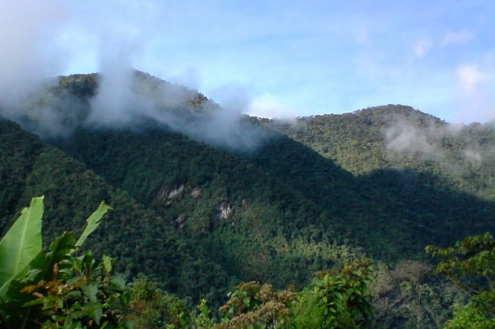
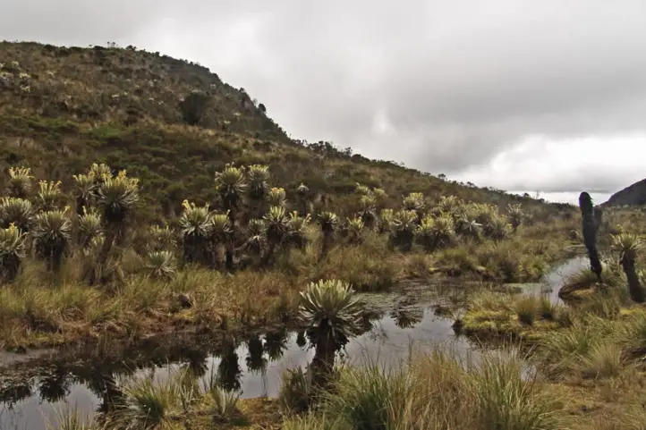
5. Barichara – Santander
Barichara is considered the most beautiful town in Colombia, it is a charming place for lovers of photography and colonial architecture. Its name, which comes from the Guane dialect, derived from the Chibcha, means “place for rest”.
Nature Activities and Attractions in Barichara
You can enjoy the viewpoints present in the town, such as the Salto del Mico, which is not far from the center of town.
You can also visit the Cathedral of the Immaculate Conception, considered one of Baricharás must see.
If hiking is within your hobbies, Barichara’s Lengerke trail, a walk of approximately 2 hours that continues to the towns of Guane and Zapatoca is highly recommended;
Visit the cemetery, it is not a plan that many tourists usually do but the cemetery of Barichara will enchant you with its beautiful architecture.
10 minutes away by car you will be able to enjoy Moncora Biopark, where you will have a plan to connect with nature and you can do bird watching.
Our recommendations for hotels in Barichara: Hotel Hicasua and Convention Center, Hotel Buenos Aires Barichara, Hospedaje Donde Lorenzo, Hotel Campestre Ataraxia Barichara and Hotel Terra Barichara.
This beautiful town is located 9 Km from the capital of the department, Bucaramanga, where you can have the opportunity to appreciate houses and constructions of the XVI, XVII and XVIII centuries.
This led to this city being declared a National Monument in 1963.
Nature Activities and Attractions in Girón:
Colonial Bridges, Giron has 6 colonial bridges that are still in use today and connect the different areas of the town.
El Humedal del Pantano, in this wetland you can have all the information of the flora and fauna of the region.
Las Iguanas Waterfall, this beautiful waterfall is made up of stones located in a special way that make it a jewel of the department of Santander, you can visit just 30 minutes from the center of town.
Our hotel recommendations: Macaregua Hotel Boutique and Hotel Las Nieves.
7. Socorro – Santander
It is considered one of the most important historical towns in the independence of the country, and hometown to many of the heroes of rebellion who fought for independence, among which is the heroine Manuela Beltran.
Socorro’s streets still have a colonial republican style where you can still feel the courage of a people that took the first steps for the revolution of the country.
Nature Activities and Attractions in Socorro:
Socorro has the most traditional independence park in the country, since it is known that the Comuneros (a warlike group that rebelled against the Spanish Empire) began to gather here.
The Cathedral Nuestra Señora del Socorro is one of the largest 19th century constructions in the country, an ideal place to take excellent photographs due to its architecture and beauty.
The Suarez River is a natural attraction 30 minutes away from the center of town where you will be able to relax and have contact with the nature of the sector, in addition to water activities such as rafting and canoeing.
Socorro is very close to the municipality of Curuti so you can visit a cave that is located on the border of these two municipalities, you can perform activities of speleology with the support of the guides of the municipality.
Our recommendations for hotels in Socorro: Hospedaje Los Capuchinos, Hotel Villa Del Socorro and La Serrana Hostal Spa.
Heritage Towns in Antioquia – Chocó Corridor of Colombia
8. Santa Fe de Antioquia-Antioquia
It is considered the heritage town with more history of Colombia, as it was considered the center of economic and cultural development of the region.
It was formerly the capital of the department of Antioquia, besides being one of the best preserved towns in Antioquia in its traditional architecture.
Nature Activities and Attractions in Santa Fe de Antioquia
Your tour through the streets of this beautiful town will leave you amazed, thanks to its architecture in large balconies and huge carved wooden doors.
Walking across the Cauca river over the Puente de Occidente will be a plan that you will love, the beautiful structure will amaze you, besides being the scene of beautiful photographs.
Birdwatching
Our recommendations for hotels in Santa Fe de Antioquia: Hotel Arena Santa Fe de Antioquia, Hotel la Ardilla de Santa Fe and Hotel Santa Barbara Colonial.
It is one of the most important religious tourist destinations in the country; Jerico was also the birthplace of the holy mother, Laura Montoya Upegui. It is a beautiful colorful town with 17 temples that adorn the religiosity of its inhabitants.
Nature has also been generous with Jerico, its tutelary hills are a favorite destination for hikers and ecology lovers. And its Main Park, one of the most beautiful in Antioquia, preserves an architecture that evokes the best years of the coffee culture.
Nature Activities and Attractions in Jerico:
If you want to learn more about the history and religious culture of the town you cannot miss the Archaeological Museum of the Southwest and the House of Culture of Monsignor Pompilio Gallego Arboleda.
One of the most striking attractions of the town is its beautiful Nuestra Señora de Las Mercedes Cathedral, which stands out for its orange tones on the roof contrasting with the mountains surrounding the town.
Los Balsos Botanical Garden, a place where you can learn about the fauna of the town and the species that are present there.
The viewpoint of Cristo Redentor is the highest view of the town, after a walk you will have the most beautiful panoramic view of the town.
Hikes in Morro El Salvador, Río Piedras, Chorros de Quebradona.
Visiting Las Playas Spa.
Paragliding, Paramotoring, Hang Gliding, Mountain bike.
Cerro Tusa and Jerico Helicopter Tour.
Ecological tour of the Coffee and Rainbow waterfall in Jericó.
Hike in Las Nubes Natural Park at sunset in Jericó
Our recommendations for hotels in Jerico: Hotel Santa Laura, Hotel Atenas Jericho, El Despertar Hotel, Hotel de Cauca Viejo and Cabañas y Flores.
10. Jardín – Antioquia
Jardin has beautiful colonial architecture, which is surrounded by overwhelming green landscapes. Ecotourism is one of its strong points. It is also a perfect place to see and photograph the “Andean Cock-of-the-Rock”.
The central square of Jardin will fascinate you, you will find that the landscapes that can be appreciated seem to be from a beautiful fantasy book, besides its houses and buildings have remained almost untouched for a century.
Nature Activities and Attractions in Jardin:
To enjoy its colorful streets and beautiful architecture we recommend a tour in a Tuk Tuk, where the drivers can show you around every corner of the town for 2 hours.
Visit the Basilica Menor La Inmaculada Concepción, this beautiful gothic style basilica (named as such by Pope John Paul II himself) will enchant you and when you are inside the beautiful decoration will leave you breathless.
Among the hiking plans Jardin offers them in the outskirts of the town, there you will be able to visit La Cueva del Esplendor, Salto del Angel and have a contact with an Embera indigenous community.
Among the ecological plans you will be able to visit the Jardín de Rocas Natural Reserve, where you can go bird watching and see the habitat of the beautiful Andean Cock of the Rock (Rupicola peruvianus).
Birdwatching and visit the Proaves Nature Bird Reserve Yellow-eared Parrot (Ognorhynchus icterotis)
Around the town you can visit natural reserves, ravines and caves where you can take speleological tours.
Our recommendations for hotels in Jardin: Hosteria El Paraiso, Hotel Jardin Antioquia, Hotel Kantarrana Urbana Jardin and Hotel Diana Campestre.
Heritage Towns in the Coffee Cultural Landscape (PCC) of Colombia
11. Aguadas – Caldas
This magical heritage town is nationally and internationally recognized for its traditional aguadeño hat made from the iraca palm, besides being the site of the National Colombian Pasillo Festival.
Besides, Aguaduas is known as the “City of Fog” as it is often surrounded by thick fog.
Nature Activities and Attractions in Aguaduas:
The most important tourist attraction of the town is Guayacanes, a place of beautiful trees with colorful leaves, a great place for excellent photographs.
Francisco Giraldo Cultural Center, is a museum that was built in the XVIII century, where you can appreciate relics of the aborigines that once inhabited the area.
Museo Nacional del Sombrero, due to its typical hat the town has a museum where you will learn about the origins and elaboration process from the oldest technique to the evolution it has had until today.
Cerro Tutelar del Pipintá Cerro Monserrate, from an approximate height of 2,270 meters above sea level you can have a spectacular 360 º view, from there on clear days you can see the Nevado del Ruiz, Pácora, La Vereda el Morro, Castile, Marmato.
La Chorrera Waterfall, on the outskirts of Aguaduas 9 km from the center of town you can meet a spectacular waterfall of 50 meters high, there you can take a shower and spend a pleasant moment.
Petroglyphs El Dorado, during a 30 minutes drive you can reach a rural area where you will find caves with pictograms of more than 450 years old, it is a place that you can only visit under the supervision of authorized guides to protect these relics of the ancestors.
Our recommendations for hotels in Aguaduas: Paraiso Tropical and Casa Blanca Hotel.
12. Salamina – Caldas
Built on the top of a hill in the department of Caldas and its strategic construction makes many of its corners a fascinating viewpoint. It is a magical town of the Andean colonization.
As you walk through Salamina you will find houses of wattle and daub, calicanto and wooden balconies laden with flowers of different shapes and colors.
Nature Activities and Attractions in Salamina:
You can tour the town and let yourself fall in love with the beautiful houses and buildings of the town as well as the pila that is located in the center of town.
Finally in the wax palm forest La Samaria you will have the opportunity to appreciate a beautiful and quiet wax palm forest, it is not usually as visited as Salento, this alternative is more relaxed.
Our recommendations for hotels in Salamina: La Estancia Hotel Boutique, Hospedaje Casa Real and Bonsai Casa Hotel.
If you want more information on how to visit Salamina read this blog (Salamina’s blog).
Heritage Towns in the Central Corridor of Colombia
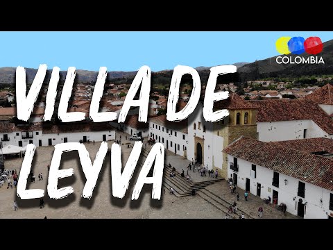
13. Villa de Leyva – Boyacá
Villa de Leyva is considered one of the most beautiful colonial towns in Colombia; this is due to the beauty of its landscapes, its houses and cobblestone streets.
Throughout the town and its surroundings you will be able to learn a lot about the historical events that occurred in this town, as well as enjoy the gastronomic and cultural offerings it has to offer.
Nature Activities and Attractions in Villa de Leyva
The first place you can enjoy on your visit is the central square, a perfect spot to shoot postcard photos thanks to the architecture of the church and the landscape of the mountains behind it. Moreover you can enjoy a diversity of local and international cuisine offered;
Villa de Leyva is well known for its museums, so you cannot miss the opportunity to visit the Paleontological museum, without leaving aside the delicious Chocolate Museum.
To get the most out of Villa de Leyva’s off road attractions we recommend that you rent a quad bike and visit: The terracotta house, Pozos azules and Pozo rojo, La Periquera waterfalls and Parque Arqueológico Monquirá.
The Cave Paintings, located 7 km from the center of town is a place where you will enjoy cave paintings of the Chibchas, an earlier indigenous culture.
The ostrich farm, if you want to enjoy a few hours with these beautiful birds and learn more about their behavior, you can do it 15 minutes away where you will be in a farm where they will explain everything about this bird.
If you are interested in nature tourism you can enjoy Iguaque Flora and Fauna Sanctuary; it is located 30 minutes by car from Villa de Leyva. This sanctuary is very special for the inhabitants of the area because it was an important point for the Muisca culture.
Our recommendations for hotels in Villa de Leyva are: Hotel La Posada de San Antonio, Hotel Campanario de la Villa, Hotel Casa Cantabria Campestre, Hotel Casa de los Fundadores, Hotel Abahunza and Hotel Casa Boutique.
It is catalogued as one of the most beautiful towns in the department of Boyacá, so you must visit it once in your life. Additionally Mongui has the recognition of being the first municipality in Colombia in the production of handmade balloons.
It is one of the coldest towns in the department so it is recommended that you bring warm clothes for your visit.
Nature Activities and Attractions in Monguí:
Minor Basilica of Our Lady of Monguí, built in the XVIII century, has a beautiful Romanesque style, making it very special. In addition, during the Holy Week season they offer to the locals and visitors beautiful shows of interpretation of the Stations of the Cross.
Colonial Bridge Real Calicanto, is the place that the lovers of photography do not want to lose, it is a small stone bridge that allowed the connection of the distant sidewalks of the town and the center of the same one. Being a construction of the eighteenth century still continues to maintain its design intact.
Páramo de Oceta, a 1 hour walk you will have access to a beautiful paramo, where through trails that can be more than 3 hours you will be able to appreciate the flora and fauna of the paramos as well as the main species of the region.
Our recommendations for hotels in Monguí: Mongui Plaza Hotel, Los Recuerdos de Florito y Leo, Hotel Otti Colonial, Hospedaje Bella Vista Monguí and Bahareque Casa Camping.
15. San Miguel de Guaduas – Cundinamarca
Guaduas was the birthplace of Policarpa Salavarrieta (also known as “La Pola”), one of the most important historical heroines of the nation’s independence.
It is located 115 km from the capital of the country, Bogotá, and is a place that has a large number of houses of wattle and daub, clay tiles and zinc that still maintain the colonial style.
Nature Activities and Attractions in Guaduas:
Piedra Capira Viewpoint, this is a beautiful viewpoint located 20 minutes from the center of Guaduas, where you will find a huge rock with a cross from where you will be able to appreciate a beautiful view of the Magdalena River.
El Salto de Versalles, it is a beautiful waterfall of no more than 40 meters high, is considered one of the most beautiful of Cundinamarca and an ideal place for photography lovers.
Santa Fe Royal Road, is an old cobblestone road that linked Bogota with the municipality of Honda, this road crosses the municipalities of Facatativá, Albán, Villeta and Guaduas.
Our recommendations for hotels in Guaduas: El Portón de Enriqueta, Hotel Paso Realce, Quinta Baroe, La Rosa Nautica Hostel and Hotel Casa Blanca.
16. Honda – Tolima
It is the only town of heritage located in the department of Tolima, its importance lies in its proximity to the Magdalena River and being the way of connection with the cities of Barranquilla and Cartagena.
It was considered in the past as the first port of Nueva Granada, currently still retains a large number of bridges and buildings of the colonial era.
Nature Activities and attractions in Honda:
You will love walking in the historic center of the town, especially the Calle de las Trampas, this was a colonial sector where it is considered that the Viceroys of Spain lived.
Among the museum options there are two, the Magdalena River Museum and the Alfonso Lopez Pumarejo House Museum; in them you will learn about the history and importance of this town for the country.
Walk over the Navarro Bridge, considered the oldest bridge still in operation in South America; you will find it 200 meters from the historic center of the town.
Agrotourism and Birdwatching.
Hiking and horse riding.
Our recommendations for hotels in Honda: El Virrey Hotel Boutique, Hotel Boutique Posada Las Trampas, Casa Celeste Honda, Waka Hotel Rural and Hotel Calle Real Honda.
Heritage Towns in the Pacific Corridor of Colombia
17. Guadalajara de Buga – Valle del Cauca
It is a town of great importance for worship and peregrination both nationally and globally, thanks to the Basilica of the Lord of Miracles, one of the most visited places. But Buga is also a point of conservation of flora and fauna.
Activities and attractions in Guadalajara de Buga
Yotoco Forest, which is the largest tropical forest reserve in the department you will be able to appreciate the howler monkeys and Sonso Lagoon is an ideal place for bird lovers.
El Vínculo Regional Natural Park, it is the largest reserve of the tropical dry forest ecosystem in Valle del Cauca, declared a regional natural park in 2006. It has a set of ecological trails with beauty and rich landscape, hundreds of birds, flowers, trees and animals in danger of extinction, typical of dry forest.
Sonso Lagoon, it is located within the wetland complex of the upper Cauca river basin, in the municipality of Buga, between the Guadalajara and Sonso rivers. It is the main wetland in the alluvial plain of the Cauca River and the last redoubt of the lagoon ecosystem within the strategic Tropical Dry Flooded Forest ecosystem.
Our recommendations for hotels in Guadalajara de Buga: Chrisban Hotel Boutique, Hotel El Faro Buga and Hotel Ciudad Señora Buga.
Heritage Towns in the Llanos Corridor of Colombia
18. Pore – Casanare
It is the first town of the eastern plains that enters the list of heritage towns in the country. In the case of Pore, it is considered the first capital of freedom and democracy of the New Granada.
Located 72 km from the capital of the department, Yopal, there you will be able to find relics of great importance such as the prisons built by the Spanish, the cobblestone streets and the mansions that preserve the colonial style.
Nature Activities and Attractions in Pore:
Quebrada la Niata, a few kilometers from the center of town you will find a beautiful creek of crystalline waters where you can take a bath and spend the afternoon without inconvenience.
In ecological tourism, Laguna de Piña Corozo is a magical place that you will find 30 km from the center of town, there you can make migratory and permanent bird watching in the sector.
Zamaricote Natural Reserve, being the only fluvial star of Casanare, from that point are born approximately 64 streams and rivers, enriched with its myth of the enchanted lagoon, ecological walks and descent by rope to the source of the river Pore.
Tour through the historic center of the town, through your tour you can see the deteriorated walls that show signs of the passage of the Spaniards through this town along with the abandoned prisons.
Our recommendation of hotel in Pore: Hotel El Tesoro Del Llano
How many of Colombia’s heritage towns do you know?
No matter the answer now you have a list of magical places to discover, get out of the routine and fall in love with this beautiful country.
About the authors
Sara Colmenares
The current director of Sula. Doctor in Biological Sciences. Her main interests are to explore and understand the organism-environment interactions, taking advantage of emerging knowledge for the management and conservation of species and ecosystem services. She is currently working as a consultant in functional ecology, ecosystem services, and conservation projects in Colombia related to ecotourism and birdwatching.
Luisa Martin
Engineer, world traveler, amateur photographer, traveling blogger, and foody.
In west of the city of Cali you will find páramos, waterfalls, trails, mountains and rivers hidden in the youngest rock formations of the Western Cordillera of the Andes: Farallones de Cali Natural National Park.
This protected area, distinguished by its majestic blue peaks that rise above a plain that separates the basins of the Pacific and the Cauca River, is recognized for its great natural wealth and therefore becomes a must-see destination when it comes to nature tourism in this region of the country.
Below you will get the information you need to enjoy and fall in love with the largest natural reserve in Valle del Cauca.
Discovering Farallones de Cali Natural National Park
Farallones de Cali National Park is located in southwestern Colombia, in the department of Valle del Cauca, between the municipalities of Cali, Jamundí, Dagua and Buenaventura, covering an area of 1,500 km².
The “farallones” are rock formations of about 20 million years ago, being the youngest of the Western Cordillera of the Andes, formed by the folding of the South American and Nazca tectonic plates.
The protected area is the largest in Valle del Cauca and allows the conservation of more than 540 bird species and more than 30 rivers that originate there. The rivers and streams that originate in this area are divided into two basins: the Cauca and Pacific basins, and supply the southwestern part of Colombia.
Pance Peak, Farallones de Cali National Park, CC Parques Nacionales Archives
The elevation gradient is between 200 and 4,100 meters above sea level, where the following ecosystems are present:
Tropical Rainforest (200 and 1,200 meters above sea level);
Humid Sub-Andean Forest (1,200 and 2,000 meters above sea level);
Humid High Andean Forest (2,000 and 3,500 meters above sea level) and
Páramo (above 3,500 meters above sea level).
Farallones de Cali NNP has the only paramo ecosystem in Colombia that does not have frailejones. However, the park is considered one of the richest in flora and fauna Colombia.
How to get to Farallones de Cali Natural National Park
Bogotá-Palmira-Pance
Take a 145- minutes flight from El Dorado Bogotá (BOG) to Alfonso Bonilla Aragón International Airport (CLO) at Palmira city. Once at the airport, take an approximately 45- minutes ride to Pance at Centro de Educación Ambiental El Topacio.
What to do in Farallones de Cali NNP
Colombia’s National Natural Parks announced that as a contribution to the country’s economic reactivation and as a continuation of the reopening of protected areas with an ecotourism vocation, the Farallones de Cali National Natural Park reopened its doors so that visitors can enjoy its natural and cultural values.
Authorized sectors for entry
The organization, in charge of administering and managing the Natural Parks System and coordinating the National System of Protected Areas of Colombia, announced the following points that will be authorized for visitors:
Puesto de atención a visitantes el Topacio, located in Vereda el Topacio Corregimiento de Pance, Distrito de Cali, access to the attractive Pico de Loro.
Quebradahonda Visitor Service Station, located in the Quebradahonda Village, Corregimiento de los Andes, District of Cali, access to the Peñas Blancas attraction.
Km 81 Visitor Service Station, located in La Cascada, municipality of Dagua, access to the Cañón del Anchicayá attraction.
Schedules and measures to take into account
National Parks informed that visitors will be able to enjoy the protected area “in day trip mode” and it is important to follow the instructions of the park rangers, the National Police and members of the communities that provide ecotourism support.
The entrance hours are from 6:00 a.m. to 8:00 a.m. and the departure time should be no later than 5:00 p.m.
Biosecurity protocols
At the same time, the entity highlighted the recommendations and biosecurity protocols, which have been developed given the pandemic situation and among which are: maintaining social distance, permanent use of masks and glycerin alcohol, as well as avoiding crowds.
Additionally, the tourist load capacity of each of the trails has been reduced to 30% for this reopening stage, and also police accompaniment is provided.
What to enjoy in Los Farallones?
In this protected area you can spot species such as the spectacled bear and the anteater, along with guans, chachalacas, parrots and eagles.
Los Farallones de Cali National Natural Park, located in the Western Cordillera of Colombia, allows visitors to enjoy relaxing landscapes, which are also home to marsupials and monkeys, as well as camping and hiking activities.
Hiking
Hiking is an exciting activity in Farallones de Cali National Park. You can hike on 4 trails: Pico de Loro Trail; Burbujas Trail; Peñas Blancas Trail and Anchicayá Canyon.
Pico de Loro Trail: Starting point 1718 masl to 2860 masl arrival point. Difficulty level: Medium – High and maximum capacity of 50 people per day. (3 hours)
Burbujas Trail: Starting point 1676 masl to 1735 masl arrival point. Degree of difficulty: Low and maximum capacity of 267 people per day.
Peñas Blancas Trail: Starting point 1987 masl to 2886 masl arrival point. Degree of difficulty: Medium – High and maximum capacity of 50 people per day.
Anchicayá Canyon: It is a natural well with a depth of approximately 80 cm to 6 meters. Degree of difficulty: Low-Medium and maximum capacity of 200 people per day.
Birdwatching
Tororoi Bailador. CC Diego Calderón (Colombia Birding)
The most representative birds of the park are the:
Land of the Tororoi Bailador, or the Dancing Grallaria
Species number 562 was named Tororoi Bailador, which was discovered in the Dagma conservation area, immersed in the Farallones de Cali National Natural Park.
Thus, the Tororoi Bailador is an endemic bird recorded in the park, and it is known to be present in five rural territories near the park.
Wildlife Tours
In Farallones de Cali NNP you can observe small bats up to pumas, in addition to panthers, ocelots, foxes and spectacled bears.
The amphibian community includes the Lehman’s poison dart frog,Oophaga lehmanni. Check our dart frogs tour here.
Thanks to the proximity of Farallones de Cali NNP with the city of Cali it is not necessary to stay overnight in the park.
We recommend you to stay in Cali, where there are plenty of nice hotels you can stay. Our recommendations for you are:
Hotel Casa del Hidalgo
Hotel Dann Carton Cali
Cali Marriot Hotel
Best time to visit Farallones de Cali NNP
We recommend that you visit the park during the 2 dry seasons, between the months of January and March, and between July and August.
Keep in mind that Farallones de Cali NNP has an average temperature of 25º C (77º F) in most of the marked trails but in the summits it has a temperature of 5º C (41º F).
Farallones de Cali NNP Entrance fees
Farallones de Cali NNP does not currently charge admission to visitors.
What to consider before visiting Farallones de Cali NNP
The park currently has regulated access, so you must request access to the following email farallones@parquesnacionales.gov.co.
The hours of entry and permanence of the trails allowed in the park are:
Pico de Loro Trail: Entrance from 6 am to 8 am; departure 4 pm maximum;
Burbujas – Pance: Entrance from 6 am to 5 pm;
Peñas Blancas Trail: Entrance from 6 am to 8 am; departure 4 pm maximum;
Anchicayá Canyon: stay from 7 am to 5 pm.
The Pico Pance trail is currently restricted because it is in an intangible zone.
The entry of pets or domestic animals is prohibited.
The use of flash when taking photographs is prohibited.
Use of binoculars to watch animals’ behavior is recommended.
Bring along valid identification documents and health insurance.
It is recommended to be vaccinated against yellow fever and tetanus.
If you take specific medications, take them with you a personal first aid kit.
Some prohibitions
Feeding, bothering or hunting animals, alcoholic drinks and drugs, throwing cigarette butts, burning garbage, felling, and capturing wildlife.
References
Parques Nacionales
Colombia.travel
Colparques
About the authors
Sara Colmenares
The current director of Sula. Doctor in Biological Sciences. Her main interests are to explore and understand the organism-environment interactions, taking advantage of emerging knowledge for the management and conservation of species and ecosystem services. She is currently working as a consultant in functional ecology, ecosystem services, and conservation projects in Colombia related to ecotourism and birdwatching.
Luisa Martin
Engineer, world traveler, amateur photographer, traveling blogger, and foody.
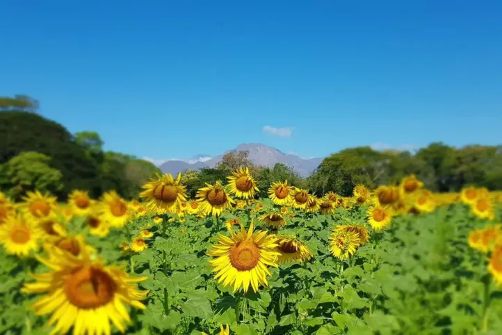
The Sunflower (Helianthus annuus, the common sunflower) is worldwide known for its beauty and Vincent van Gogh paintings. The blooming of this beautiful flowers everywhere attracts many people to the so-called sunflower tourism.
Although they are treated as weeds, they fulfill an important function: their ability to grow in all types of environments and their resistance to drought allows them to invade degraded sites, where they detain the soil. Also, because they produce a lot of nectar, they attract numerous pollinators, such as bees.
Origin of Sunflowers
Indigenous domestication
Sunflowers were domesticated by Mesoamerican Indian tribes, and are traditionally associated with pre-Columbian Mexican cultures. They were cultivated more for their usefulness than for their beauty.
However, the sunflower was used as a symbol representing the sun deity, primarily by the Aztecs and Otomies in Mexico and the Incas in Peru.
In 1532, Francisco Pizarro entered Peru, where he found a gigantic sunflower that the indigenous people of the Inca empire worshipped as a sacred image of the sun god. Then, gold figures of this flower, as well as seeds, were taken to Europe at the beginning of the 16th century.
Crops and Sunflower Tourism
Nowadays, their cultivation for oil extraction has been widespread in Spain since about 1980, thanks to subsidies from the European Economic Community. The same happens in the United Stated.
However, this is not the only appeal of sunflowers; the beauty of their fields attracts millions of tourists around the world.
Today there are sunflower fields on every continent, but the sunflower fields in Spain and Italy are the most famous for their unparalleled beauty.
The most beautiful sunflower fields in Spain are those found in the regions of La Bureba in Burgos, Cardejón in Soria, Carmona in Seville and Antequera in Malaga.
On the other hand, the most famous sunflower field in Italy is in the Tuscany region.
Sunflower Movement
Every day, sunflowers move towards the sun, following it on its east-west route. At night they move in the opposite direction, as if waiting for the sun to rise the next morning.
But one day they stop doing so, since when they reach maturity they stop their dance, do not turn again and remain oriented indefinitely towards the east until they die.
This movement, called heliotropism, is regulated by the circadian rhythm of the plants, and favors their growth.
And the truth is, it is not the flower that turns, it is the uneven growth of its stems that causes the turning. And when they stop growing, they stop turning.
That they stop is not entirely sad, since when they reach maturity, the plant is ready to be pollinated. The flowers release additional heat, which makes them more attractive to pollinating insects.
Find out more in the Science ReportCircadian regulation of sunflower heliotropism, floral orientation, and pollinator visits: Sun-tracking when young, east-facing when mature, warmer sunflowers attract more pollinators.
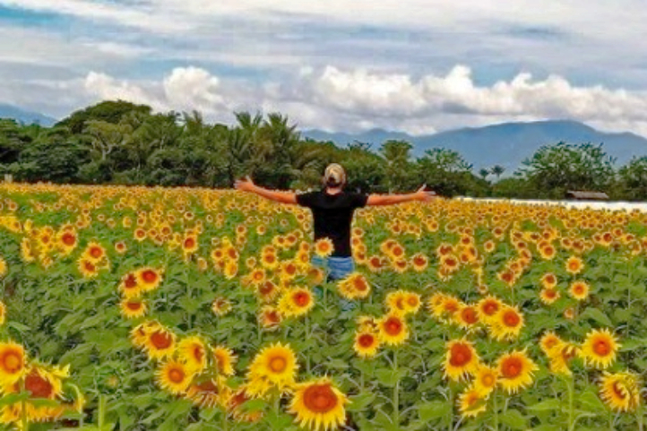
Sunflower Tourism in Colombia
Research on sunflower cultivation in Colombia has been carried out since the late 1950s. But it was not until 1985 that the first sunflower field was planted for commercial production. The first crops were planted in Valle del Cauca, Tolima and Cesar.
In general, sunflower grows well in Colombia, from sea level to 2600 meter above sea level, so much so that today there are crops in Bogota. However, it was not until 2020 that some fields began to be used for tourism.
Today, there are several destinations where you can visit sunflower fields in Colombia, bu today I am goiong to talk about the most suitable for visit: San Martin, in the department of Meta, in the eastern plains of Colombia, Montes de Maria in the department of Bolivar, in the Colombian Caribbean region, and Valledupar in the department of Cesar, also part of the Caribbean region.
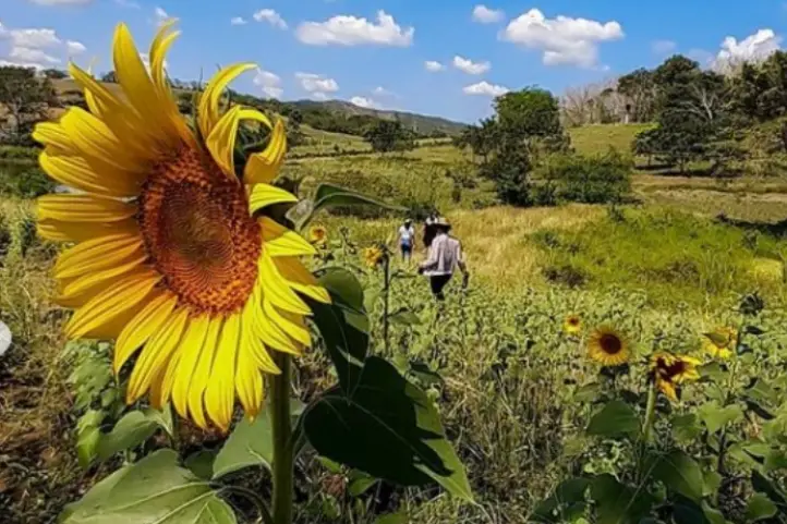
Sunflower Tourism in San Martin, Meta
Sunflower Tourism in San Martin de Los Llanos, Meta, Colombia CC @campodegirasolessm
The municipality of San Martin de los Llanos is located one hour from Villavicencio, capital of Meta. The annual sowing of sunflowers in a private plot of land in San Martín de los Llanos is the place that delights the visitor’s eyes with a minefield of this plant.
For more than five years, between the months of October and November, the sunflower crop blooms, and every year tourists are treated to the experience of walking among a crop of large and impressive sunflowers.
The tour starts at 10:00 in the morning or at 3:00 in the afternoon, from the municipality of San Martin with the indications of the authorized guides.
To get there you have to cross a 3-kilometer dirt road from San Martin; since it is private land, it is not permitted to indicate the exact location of the place.
Sunflower Tourism in Montes de María (or Serranía de San Jacinto), Bolívar
Sunflowers in San Jacinto, Bolivar, Colombia. Pic. by @yulart__
Between the departments of Bolívar and Sucre, in the Colombian Caribbean, is located the sub-region of Montes de María, a vast territory of agricultural and livestock tradition whose geographical location consolidated it as a corridor that connects a large part of the country with the Caribbean region and some of its main ports.
The Montes de María (also known as Serranía de San Jacinto) length does not exceed 110 km and its altitudes are less than 1,200 meters above sea level.
Montes de María, a Post-conflict Destination
The Montes de María area suffered from conflict for years, being a zone of FARC-EP guerrilla activity and paramilitary groups including the AUC. A particularly difficult period was in the late 1990s and early 2000s.
For years, this territory was forgotten, but now it is reappearing to conquer Colombians and foreigners with its beauty. In addition to the handicrafts, bagpipes and natural landscapes, there is a sunflower field, which has become another tourist attraction.
Tourism, entrepreneurship and sustainability
In the Sibar farm there is fish farming, chicken breeding and now, beekeeping that began to be generated thanks to the planting of these sunflowers.
It is an eco-efficient farm, where nothing is thrown away. The chicken feces (chicken manure) are used as fertilizer for the sunflowers. The flour from the sunflowers is fed to fish and chickens.
Bee Keeping Crops: The company AgroFrance sold the sunflower seeds to the farm owners
Sibar Farm and its Sunflower Fields
The idea arose as a result of the pandemic. Originally, it was a soy-based poultry feed manufacturing company. Due to the covid-19 pandemic, they came up with the idea of using sunflower meal as raw material for concentrate plants for cattle, sheep, swine, fish and poultry feed.
The company AgroFrance sold the sunflower seeds to the farm owners, and gave them technical assistance for planting, which is how the three-hectare sunflower field was born.
This sunflower variety produces grains with high protein, vitamin and fiber content, which have different uses for human consumption. These characteristics make this field even more special for tourists.
The field is located on the Sibar farm, on the outskirts of the municipality of San Jacinto, and very close to the Troncal de Occidente highway in the Montes de María.
Entering to contemplate the 180 thousand sunflowers has no cost. The only recommendation of the owner Alfredo Villadiego is that the visit is made with all the biosecurity protocols and without making noise because they can scare the bees!
Sunflower Tourism in Valledupar, Cesar
Sunflower Fields in Valledupar, Cesar, Colombia CC Publimetro.co
The cultivation of sunflower in the department of Cesar arose thanks to the union of several farmers. As in Bolivar, AgroFrance International distributed the seed to the local agricultural farmers.
The crops are located on the road that leads to the village of El Jabo, five minutes from Valledupar, at Finca La Esmeralda, and there are other fields distributed in the village of Los Venados, and in the municipality of Urumita in La Guajira.
Sunflower as an Alternative Crop
Sunflower cultivation in Cesar has become a planting alternative due to the scarce markets for rice, corn, cotton, sorghum, and other products, and it is a plant that does not require abundant water. Farmers in the area hope to harvest the grain to take it to agribusiness as oil or flour.
Bee sanctuary, therapeutic and tourist attractiveness
The harmonious and constant buzzing of bees accompanies this yellow feast, making it a sanctuary for bees. Thousands of bees arrive in swarms from the mountains to give life to the crops and help the pollination of this plant.
Some countries such as Germany, Austria, Denmark, Spain, Belgium, France and Greece must implant bee hives, artificially, due to the scarcity of this insect in these countries.
One of the owners of the crops has witnessed how hundreds of people come to appreciate these flowers, and for the landscape impact of 200 thousand sunflower plants framed under the silhouette of the Sierra Nevada de Santa Marta, which for some resembles Swiss landscapes.
The fields have even been visited by several people with health problems to enjoy the beauty of the crop. In this way, they are contributing to the community.
Important Precautions When Visiting a Sunflower Field
You should wear appropriate footwear for the tour and the mud.
Avoid wearing strong perfumes before visiting, as they attract bees.
In addition, it is recommended not to run inside the field and it is forbidden to cut the sunflowers.
Remember, these places are especially for those who wish to enjoy nature.
If you want to know more about nature and agro-tourism destinations in Colombia do not hesitate in contact us or visit our Plan your trip page.
The current director of Sula. Doctor in Biological Sciences. Her main interests are to explore and understand the organism-environment interactions, taking advantage of emerging knowledge for the management and conservation of species and ecosystem services. She is currently working as a consultant in functional ecology, ecosystem services, and conservation projects in Colombia related to ecotourism and birdwatching.
Los Colorados Flora and Fauna Sanctuary is the largest and most conserved area of dry tropical forest in the department of Bolivar, in the region of Montes de María, or Serranía de San Jacinto.
The sanctuary’s name alludes to the presence of the Colombian Red Howler Monkey (Alouatta seniculus), which live along with tamarin monkeys, deer, ocelots, sloths, and other mammals.
This is not a very well known destination among tourists, but it has all the necessary natural attractions to be a very good natural destination, and only 90 km from Cartagena!
Discovering Los Colorados Flora and Fauna Sanctuary
Los Colorados FFS is located in the Colombian Caribbean, in the department of Bolivar, in the municipality of San Juan Nepomuceno. The sanctuary has an area of 10 km².
It contains a representative area of the largest tropical dry forest of the Montes de María or Serranía de San Jacinto, a geological formation isolated between the coastal plain of Bolívar and the savannas of Corozal and Sincelejo.
You will find a small mountain system, with several peaks such as La Cañada, El Escondido, San José, El Yayal, La Gervedera and Tamarindo de Mico.
The sanctuary is also an important provider of water to the region, and there are several mini reservoir built in the surroundings. Los Cacaos and Salvador are two small rivers which flow around the park, there are are also countless creeks that flow into these streams.
A Sanctuary for the Conservation of Tropical Dry Forest and Monkeys
It contains one of the best preserved relicts of dry forest in the region and is an important refuge for the organisms of this habitat, such as some primate and mammal populations.
Los Colorados FFS as an Important Bird Area
The Galeras FFS is an Important Bird Area (IBA/AICA) recognized by BirdLife International, since Globally threatened species and Restricted-range species are present in the area. It is also a feeding station for migratory birds and it has more than 280 reported bird species, 46 of which are migratory.
Archeological Importance
Within the sanctuary’s facilities you can visit places of great cultural importance such as ceremonial sites of local indigenous communities.
The Malibú Mokaná or Malibú Serraneros ethnic group inhabited this area in the past XVI century. You can see some archaeological vestiges found in the area of influence of the Sanctuary, such as ocarinas and petroglyphs, and also the well-known “centellas” stones.
The inhabitants of the region have established an important relationship with Los Colorados hill, impregnated with beliefs and cultural practices evident, for example, in the treatment given to medicinal plants.
How to get to Los Colorados Flora and Fauna Sanctuary
Bogotá – Cartagena – San Juan Nepomuceno
Take a 45- minutes flight from El Dorado Bogotá (BOG) to Rafael Nuñez International Airport (CTG) at Cartagena city.
From Cartagena take the road to Sincelejo passing through the towns of Turbaco, Arjona, Sincerin, El Viso, Malagana, San Cayetano and Carreto until you reach the municipality of San Juan Nepomuceno, 90 kilometers from Cartagena.
From there you can access the entrance road to the eastern side of the Sanctuary by motorcycle or vehicle (5 minutes) or walking (20 minutes) to the operational headquarters.
What to do in Los Colorados Flora and Fauna Sanctuary
The Sanctuary and surrounding area is an ideal destination for photography, bird watching, and enjoying the natural beauty and culture of the region.
Hiking
As a visitor you can tour the mountain from east to west, through trails such as ‘El Yayal’ or ‘Planeta Bosque’, along the banks of Los Cacaos stream, paths to bring out the wild soul and become environmentally conscious.
You can visit the following tourist attractions within the sanctuary: Los Chivos waterfall, El Mirador, Los Cacaos stream, Escondido gully, Tigre’s cave, Piedra del Toro and Tinamú.
Planeta Bosque Trail
Planeta Bosque is an interpretative trail, which has a duration of 3 to 5 hours with a low degree of difficulty. It is ideal for bird watching.
Birdwatching
The number of bird species recorded in the sanctuary is 152 species divided into 40 families. Among the species that you can see are:
Macaws (Ara macao, Ara chloropterus, Ara severus, Ara ararauna)
Guans (Penelope purpurascens)
Chachalacas (Ortalis ruficauda)
Red-throated caracara (Ibycter americanus)
Toucans (Ramphastos sulfuratus).
Black-crested antshrike (Sakesphorus canadensis)
Wildlife Tours
Los Colorados FFS is considered a great refuge for species characteristic of the local dry forests, there are records of more than 40 mammals. Among the species of mammals that can be seen are:
Alouatta seniculus
Saguinus oedipus
Bradypus variegatus
Choloepus hoffmanni
Pecari tajacu
Dasyprocta punctata
Leopardus pardalis
Leopardus wiedii
Potos flavus
The sanctuary is also the transitory habitat of the Jaguar (Pantera onca).
Los Colorados FFS has records of 29 amphibian species, 20 genera and 10 families, and 21 families of reptiles.
Where to stay in Los Colorados Flora and Fauna Sanctuary?
Los Colorados FFS does not currently offer lodging services for visitors. But it is very close to the towns of San Juan Nepomuceno and San Jacinto where you can stay. Our recommendations for you are:
San Juan Nepomuceno: Hotel Malibu
San Jacinto: Bello Horizonte and Hostal las Palmas
Best time to visit Los Colorados Flora and Fauna Sanctuary
It is recommended to visit the park during the 2 dry seasons, between the months of December and April, and between July and August.
Los Colorados Flora and Fauna Sanctuary Entrance fees
These are the entrance fees for 2021:
Los Colorados FFS has a single entrance fee of COP 6,500.
Children under 5 years old and Colombians over 65 years old have free admission upon presentation of their identity documents.
What to consider before visiting Los Colorados Flora and Fauna Sanctuary
You should wear long pants, t-shirt or long sleeve shirt and comfortable shoes. In the rainy season, we recommend marsh boots.
The entry of pets or domestic animals is prohibited.
The use of flash when taking photographs is prohibited.
Use of binoculars to watch animals’ behavior is recommended.
Bring along valid identification documents and health insurance.
It is recommended to be vaccinated against yellow fever and tetanus.
If you take specific medications, take them with you a personal first aid kit.
Some prohibitions
Feeding, bothering or hunting animals, alcoholic drinks and drugs, throwing cigarette butts, burning garbage, felling, and capturing wildlife.
References
Colparques
Parques Nacionales
About the authors
Luisa Martin
Engineer, world traveler, amateur photographer, traveling blogger, and foody.
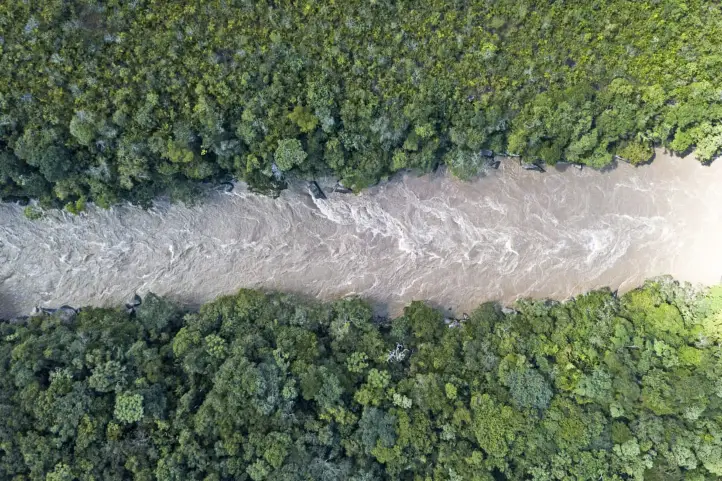
Tinigua National Natural Park is a stunning protected area of Colombia where the Andean, Orinoco and Amazonian ecosystems converge in this territory, which gives it a high biological diversity, and wonderful place for ecotourism.
Today, this place can be visited together or as an alternative destination for Caño Cristales, the famous rainbow river. In the park you can enjoy the beautiful landscapes and a huge variety of flora and fauna.
The following information will be useful during your visit to Tinigua NNP.
Discovering Tinigua National Natural Park
The Tinigua NNP is located in the department of Meta, in the jurisdiction of the municipalities of La Uribe and La Macarena, between the Duda and Guayabero rivers and has an area of 2018.75 km².
The rainforest constitutes 86% of the area of Tinigua NNP, extending over an area of 184,983 ha. Flooded forest makes up 14% of Tinigua NP’s area, covering 30,184 ha along the Perdido, Duda, Guayabero and La Reserva rivers that comprise the protected area.
Furthermore, the topography of Tinigua NNP is undulating and smooth, with altitudes ranging between 200 and 500 meters above sea level. It is characterized by forests of very tall trees, with a canopy between 30 and 40 m.
The Biological Corridor of the Area
Tinigua is part of a biogeographic corridor that goes from the top of the eastern Andean mountain range to the Amazon basal zone. In other words, it is an altitudinal gradient that begins in the Andean paramo ecosystem, at more than 3500 meters above sea level, to the Amazon and Orinoco plains.
Guayabero River at Tinigua Natural National Park. Picture by Giovany Pulido
Thus, its important geographical position and connectivity made it part within the territorial planning figure of special environmental importance in the department of Meta, La Macarena Special Management Area (AMEM), which includes four (4) National Natural Parks: Sumapaz, Cordillera de los Picachos, Sierra de La Macarena and Tinigua, and three Integrated Management Districts. Additionally, it is part of the Duda River corridor in the valley of the Eastern Cordillera near the Serrania de la Macarena.
Such a corridor allows the flow of living beings and the provision of ecosystem services.
Hydric Importance
Tinigua National Natural Park is important for water because it conserves four (4) hydrographic basins: Guayabero River, Guaduas River, Perdido River and Duda River that allow the formation of the Guaviare River and the Orinoco macro basin.
Cultural Importance
Downstream along the Guayabero River is the Raudal Angostura I, a Historic-Cultural Zone, in which there are giant rocks of great scenic beauty, and other attractions such as petroglyphs of zoomorphic and anthromorphic figures, which are vestiges of the cultural legacy of indigenous inhabitants from the Tinigua and Guayabero ethnic groups in this territory.
According to studies, only one member of the Tinigua indigenous culture remains, named Sixto Muñoz Mauricio, who speaks the Tinigua language, preserves some of the customs and lives deep in the jungle of the Sierra de La Macarena.
How to get Tinigua National Natural Park
Bogotá-La Macarena
Take a 1-hour flight from El Dorado International Airport (BOG) Bogotá to La Macarena Airport (LMC) at La Macarena city with Satena airline.
From La Macarena you have to take a road trip of approximately 7 hours to Delicias- Centro Poblado San Juan del Losada- Centro Poblado el Rubí- Cabaña Aires del Perdido
Bogotá – San Vicente del Caguán – Tinigua NNP Sector Losada – Perdido
Take a 1-hours flight from El Dorado International Airport (BOG) Bogotá to
Eduardo Falla Solano Airport (SVI) at San Vicente del Caguan city with satena airline. Once at the airport, take an approximately 4,5-hours ride to La Macarena.
From La Macarena you have to take a road trip of approximately 7 hours to Delicias- Centro Poblado San Juan del Losada- Centro Poblado el Rubí- Cabaña Aires del Perdido
Please note that Satena airline only operates two flights a week, on Tuesdays and Saturdays.
What to do in Tinigua National Natural Park
Main activity at the park is hiking, but there are other complementary activities such as wildlife and flora observation, birdwatching and primate watching, geological observation, panoramic views, landscape contemplation, photography and filming.
Hiking
Tinigua NNP has only authorized sector for hiking which is the Raudal Angosturas I. This tour can be done all year round, but you must keep in mind that during the winter season the Guayabero River may have restrictions due to weather conditions.
In this sector you can enjoy the Petroglyph Trail Angosturas I – La Macarena; located between the border of the National Natural Parks Sierra de la Macarena and Tinigua.
As well as it has a Low-Medium degree of difficulty, there you can observe cave paintings and petroglyphs, as well as observation of flora and wildlife. Please note that you must have authorization to enter this trail.
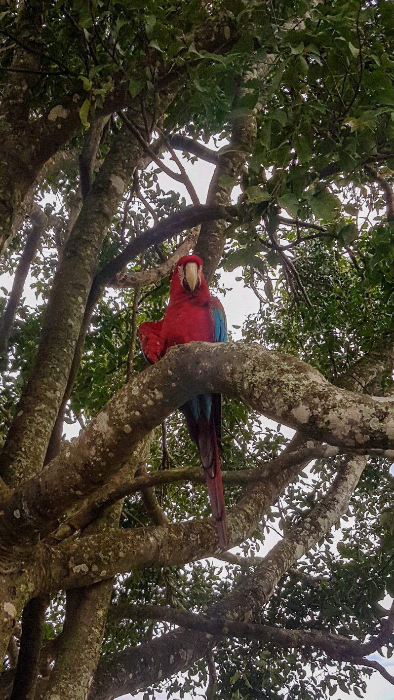
The scarlet macaw (Ara macao)
Birdwatching and Wildlife Tours
Tinigua NNP has a record of 441 bird species including 18 migratory birds and five southern migratory birds. Of the most representative birds that you can get to observe are:
Crax alector
Mitu salvini
Crax tomentosa
Ara macao
Ara ararauna
Ara militaris
Ara severa
Touit stictoptera
Neochen jubata
Coturnicops notata
Falco deiroleucus
Aburria aburri
Xiphocolaptes promeropirhynchus macarenae
Chlorospingus ophthalmicus macarenae
Tinamus tao
Pteroglossus castanotis
Ramphastos culminatus
Pionites melanocephala
Tinigua NNP has recorded 32 species of mammals, among which carnivores are the most representative specie with 9, followed by primates with 7 species. So you can enjoy your stay in Tinigua NNP discovering species such as:
Lontra longicaudis
Panthera onca
Puma concolor
Lagothrix lagotricha
Ateles belzebuth
Tayassu pecari
Tayassu tajacu
Bradypus variegatus
Tapirus terrestris
Alouatta seniculus
Saimiri sciureus
Regarding the presence of amphibians, it has been established that there are 14 species and 63 species of reptiles; where we highlight the Caiman (Crocodylus intermedius), Morrocoy (Geochelone denticulata), Anaconda (Eunectes murinus), among others.
Where to stay in Tinigua National Natural Park
Tinigua National Natural Park does not currently offer accommodation for travelers, nonetheless you are able to stay in La Macarena. Our recommendation of hotels for you:
It is recommended to visit the park during the 2 dry seasons, between the months of December and March, and between August and September. Keep in mind that Tinigua National Natural Park has an average temperature of 25º C (77º F).
Tinigua National Natural Park Entrance fees
Currently, Parques Nacionales Naturales de Colombia does not charge entrance fees for visitors to Tinigua National Park, Raudal Angosturas I Sector in the Municipality of La Macarena.
What to consider before visiting Tinigua National Natural Park
You must carry plastic bags for the disposal of NON BIODEGRADABLE waste (bottles, batteries, cans, etc.).
It is recommended that you bring: backpack, light cotton clothing, sunscreen and hat, biodegradable soap, rubber boots.
Domestic animals are prohibited.
Don’t use of flash when taking photographs.
Use binoculars to watch animals’ behavior.
Bring along valid identification documents and health insurance.
It is recommended to be vaccinated against yellow fever and tetanus.
If you take specific medications, take them with you a personal first aid kit.
Some prohibitions
Feeding, bothering or hunting animals, alcoholic drinks and drugs, throwing cigarette butts, burning garbage, felling, and capturing wildlife.
References
Parques Nacionales
Colparques
About the authors
Sara Colmenares
The current director of Sula. Doctor in Biological Sciences. Her main interests are to explore and understand the organism-environment interactions, taking advantage of emerging knowledge for the management and conservation of species and ecosystem services. She is currently working as a consultant in functional ecology, ecosystem services, and conservation projects in Colombia related to ecotourism and birdwatching.
Luisa Martin
Engineer, world traveler, amateur photographer, traveling blogger, and foody.
At the foot of the Galeras Volcano is the Galeras Flora and Fauna Sanctuary, its cliffs are excellent for the practice of extreme sports, mountaineering, paragliding and mountain biking.
Part of the sanctuary is located in a High Volcanic Threat Zone (Zona de Amenaza Volcánica Alta – ZAVA), as it is part of a volcanic complex.
The richness of the Galeras Sanctuary is reflected in the great variety of flora and fauna species in the páramo, high Andean forest, and Andean forest ecosystems. It also has lagoons and different water sources that supply the local aqueducts.
Have you ever dreamt to come close to the most active crater volcano in South America? in Galeras Flora and Fauna Sanctuary you can do it and discover much more!
Discovering Galeras Flora and Fauna Sanctuary
This sanctuary is located in southwestern part of Colombia, in the department of Nariño, and covers an area of 76.15 km².
The Sanctuary’s Role as a Water Supplier
In the Galeras Volcano Fauna and Flora Sanctuary, there is a hydrographic star that gives rise to about 125 streams, several rivers and four lagoons: Negra, Verde, Telpis and Mejía, and numerous ponds such as La Blanca, Sumatambo and La Trucha, which benefit the community of the seven municipalities that surround the park.
The 40 villages surrounding the sanctuary, local communities carry out different productive activities and depend on the water provided by the sanctuary. For this reason, they are committed to the sanctuary’s conservation and work together with National Parks to maintain it.
Moreover, because the sanctuary is located between Nariño’s two main watersheds: the Guáitara and Juanambú, protecting the páramo is vital for sanctuary officials.
Natural Attractions
Galeras Flora and Fauna Sanctuary is located at an altitude of 3,000 meters above sea level. The main ecosystems of the Sanctuary are cloud forest and paramo. The variety of topography and the diverse climatic conditions have allowed the development of a great diversity of flora.
The High Andean forest is located between 3,000 and 3,200 meters above sea, it is covered by endemic species such as the Encenillo (Weinmannia tomentosa). Then, the sub-paramo is found between 3,200 and 3,500 meters above sea level, where shrub and bush vegetation predominates, giving rise to mixed and colorful vegetation.
Finally, the paramo is found between 3,500 (3,600) and 4,100 meters above sea level, with a predominance of frailejones, and among them the endemic one Espeletia pycnophylla.
Galeras FFS as an Important Bird Area
The Galeras FFS is an Important Bird Area (IBA/AICA) recognized by BirdLife International, since Globally threatened species and Restricted-range species are present in the area.
The conservation actions carried out in the area correspond to those carried out by the Special Administrative Unit of the National Natural Parks System – UAESPNN.
Conservation responses – actions for key biodiversity include the environmental guide service and the ECOANDINO project, in which 800 families from the park’s surrounding villages participate.
The Galeras Volcano
Galeras Volcano. Picture by Ingeominas
With a height of 4276 meters above sea level, this majestic active volcano is 9 kilometers far from the city of San Juan de Pasto, and has allowed the city to develop at its feet for more than four hundred years.
It is considered one of the most active volcanoes in Colombia, and has more than three active craters in its internal cone, being one of the most important volcanoes in southern Colombia.
The native Quillacingas indigenous people called it Urcunina, which means “Mountain of Fire”, but its current name was given by the colonizers, who found its shape similar to large ships called galleys.
Pasto and Galeras Volcano 1869
This volcano is part of the Andes Mountain Range, located in the Pacific Ring of Fire, and its famous eruptions have thrilled locals and strangers alike. Its base is 20 kilometers in diameter and at the top there is a crater about 80 meters deep.
How to get to Galeras Flora and Fauna Sanctuary
Flight Bogotá – Pasto
Take a 1,5-hours flight from Bogotá to Antonio Nariño Airport (PSO) at Pasto city. Once at the airport, take an approximately 1,5-hours ride to San Felipe Sector. Once in San Felipe you must hike for 2 hours at medium-high intensity to the Galeras Flora and Fauna Sanctuary entrance.
Land routes
From Pasto, there is a surrounding road that connects the seven municipalities that have jurisdiction in the protected area linking Pasto with the towns of Nariño, La Florida, Sandoná, Consacá and Yacuanquer.
Telpis Sector
This is the only sector enabled for ecotourism; you leave from Pasto to the municipality of Yacuanquer (25 kilometers to the south), from here you can access through the San José, El Rosario and San Felipe trails (for about 5 kilometers) to the site where the hike begins to access the hut in the Telpis sector, with an approximate duration of 2.5 hours on foot.
Urcunina sector
This sector is closed to the public due to volcanic activity.
What to do in Galeras Flora and Fauna Sanctuary
Hiking
Galeras Volcano
In this attraction you can enjoy the natural beauty that covers the Galeras Volcano, and from its small summits, a fabulous panoramic view of the so-called surprise city San Juan de Pasto.
Access routes: From the road of the ring road, which takes us to the repeater tower, and from there it takes approximately two hours on foot. Its access routes are from the road of the ring road, approximately 23 kilometers.
Telpis Trail
With 1.3 km, 2½ hours one way, and medium difficulty, the trail shows the importance of the high Andean forest and paramo. During the hike you will be able to observe wildlife typical of these ecosystems.
The main attraction is the excellent panoramic view of the high mountains, at 3600 meters above sea level, and volcanoes such as Chiles, Cumbal and Cotopaxi, the latter in the Republic of Ecuador. There are also wetlands and the beautiful lagoon of Telpis.
Lagoons at Galeras Flora and Fauna Sanctuary. Pictures by Parques Nacionales
Laguna Negra Trail
There is also a trail to Laguna Negra, located south of Galeras Volcano between the municipalities of Pasto and Tangua, at an altitude of approximately 3,450 meters above seal level.
To reach this place, take a 30-minute hike from Pasto through Filadelfia, until you reach the crossing to enter the lagoon, at approximately 9 km away from Pasto city’s exit.
Foso del Duende Waterfall
Also, in the San Felipe trail where the route to the sanctuary’s cabin begins, it is possible to make a small detour from the main road to visit the Foso del Duende, which is a small waterfall.
It is a small waterfall where legend has it that a goblin appears before nightfall and dances until he gets tired and goes into the well to swim, but ends up turning into a giant trout and getting lost in the waters of the Telpis River.
Birdwatching an Wildlife Tours
Constant monitoring has led to the conclusion that there are 166 species of birds, 36 families and 117 genera. Thraupidae is the family with the highest number of species (30), including Tangara heinei, Urothraupis stolzmanni, Butraupis montana; followed by the Trochilidae family (hummingbirds) with 22 species, including Eriocnemis mosquera, Eriocnemis derbyi, Chalcostigma herrani, Ensifera ensifera, Rhamphomicron microrhychum; and the Tyrannidae family with 15 species such as Mecocerculus leucophrys, Mecocerculus minor, Ochtoeca frontalis; and the Emberizidae family with 13 species such as Atlapetes pallidinucha, Phrygilus unicolor, among others.
Regarding to other animal grouos, The Galeras FFS is a perfect place to observe the Galeras rain frog and the Harlequin toad of Nariño, especially in the Telpis Lagoon.
You can also observe the typical fauna of paramos and high Andean forest such as deer, wolves, squirrels, rabbits, porcupines, some rodents, among others. The wolf (Lycalopex culpeus) is currently threatened, so it is important to protect the sanctuary and avoid illegal hunting.
As you walk through the sanctuary’s trails, you can see a large number of butterflies. There are 88 recorded species.
Scientific Tourism and Environmental Education
The exuberant nature of the protected area and its conservation status make it a suitable place for scientific research. In addition, as in all parks open to ecotourism, environmental education activities are carried out here by educational institutions or officials who introduce visitors to the park, its conservation objectives, services, and ecotourism activities.
Landscaping
The scenic beauties of the Sanctuary are the perfect place for this activity, although if the photos or videos have commercial or publication purposes, a permit must be requested from the National Natural Parks.
Where to stay in Galeras Flora and Fauna Sanctuary
Currently , the sanctuary does not offer lodging for travelers, the registration shelter only offers information service.
At Telpis sector, it is possible to find lodging in rural houses that offer lodging services. In any case, one day is more than enough to cover the complete protected area so travelers can start their journey from Pasto city.
Best time to visit Galeras Flora and Fauna Sanctuary
The sanctuary can be visited all year round, but since it is a cold climate it can rain almost every month. July to September are the months with the least amount of rain and a temperature is around 15º C (59 ºF).
Galeras Flora and Fauna Sanctuary Entrance fees
The entrance fee varies depending on the nationality and age of the visitors. These are the entrance fees for 2021:
Colombians, foreigners holding valid residence permits and tourists from Bolivia, Ecuador and Peru (ages 5 to 25): COP 5,500
Colombians, foreigners holding valid residence permits and tourists from Bolivia, Ecuador and Peru (over 25 years old): COP 5,500
Non-resident foreigners (over 5 years old): COP 10,500
Children under 5 years old and Colombians over 65 years old have free entrance presenting their IDs.
Bear in Mind…
The Telpis sector is the only one enabled for ecotourism, the rest of the sanctuary is inaccessible because it is under high volcanic threat.
Guided assistance is mandatory.
The Telpis sector is only open from 8:00 a.m. to 12:00 m.
The entry of pets or domestic animals is prohibited.
The use of flash when taking photographs is prohibited.
Use of binoculars to watch animals’ behavior is recommended.
Bring along valid identification documents and health insurance.
It is recommended to be vaccinated against yellow fever and tetanus.
If you take specific medications, take them with you a personal first aid kit.
Some prohibitions
Feeding, bothering or hunting animals, alcoholic drinks and drugs, throwing cigarette butts, burning garbage, felling, and capturing wildlife.
If you want to know more about natural destination in Colombia, contact us in our Plan Your Trip page!
References
Colparques
Parques nacionales
BirdLife International (2021) Important Bird Areas factsheet: Santuario de Fauna y Flora Galeras. Downloaded from http://www.birdlife.org on 06/07/2021.
The current director of Sula. Doctor in Biological Sciences. Her main interests are to explore and understand the organism-environment interactions, taking advantage of emerging knowledge for the management and conservation of species and ecosystem services. She is currently working as a consultant in functional ecology, ecosystem services, and conservation projects in Colombia related to ecotourism and birdwatching.
Luisa Martin
Engineer, world traveler, amateur photographer, traveling blogger, and foody.
The lagoon where mankind supposedly originated, the ancient Muisca trails and a variety of ecosystems are some of the magical attractions to be discovered at Iguaque Flora and Fauna Sanctuary, a sacred place for the Muisca culture. The information below will be very useful for your visit to Iguaque in the Colombian Andes.
This sanctuary is located on the eastern mountain range between the departments of Boyacá and Santander, in the jurisdiction of the municipalities of Sáchica, Chíquiza, Villa de Leyva and Arcabuco, covering an area of 67.5 km².
Community Interaction with Iguaque
The communities on the periphery of the Sanctuary are mostly made up of farming families dedicated to cattle ranching and agriculture.
In the rural population, especially in Chíquiza, there is a deep rootedness for the Muisca Culture, indigenous people that inhabited the Cundi-boyacense highlands. The same is their rootedness for the natural environment that the Sanctuary offers, and they continue to venerate the Iguaque Lagoon, as a sacred natural element of their Muisca Culture.
Ecosystems You Can Know in Iguaque
The sanctuary has four different ecosystems: Páramo and subpáramo, Paramo wetlands, High Andean forest and Andean forest.
The lower limit of the páramo ecosystem is 3200 meters above sea level until it reaches 3800 masl. It is important to note that the structure of the páramo and subpáramo is very similar, mainly composed by grasslands, and the presence of Frailejones (Espeletia sp.).
Paramo wetlands
In the sanctuary you will see the following types of wetlands: lagoons, wet drains, and wet plains. These bodies provide water to the communities near the sanctuary.
High Andean forest
The Sanctuary has an anomaly that means that the differences between paramo and high Andean forest can only be clarified thanks to the plant species of each ecosystem, since there are points in the Sanctuary where they can have the same altitude.
Andean forest
In the northern sector of the Sanctuary, it is possible to appreciate this ecosystem, located at the lowest point of the Sanctuary, the average altitude ranges from 2,400 to 3,000 meters above sea level.
The Muisca Legend
As per Muisca tradition humanity originated in Iguaque lake. Here Bachué (Goddess) emerged from the lake with a child in her arms. The child grew up and became her husband and together they populated the Earth. At the end of their mission they decided to become snakes and returned to the sacred lake.
How to get to Iguaque Flora and Fauna Sanctuary
Bogotá – Villa de Leyva
To get to the sanctuary you must take a 3.5 -hour road trip from the city of Bogotá to the town of Villa de Leyva, total distance of 190 km.
When you are in Villa de Leyva you must take a 30-minute road trip of 10 km to the Casa de Piedra sector to make a 3 km ascent on foot to access the sanctuary.
What to do in Iguaque Flora and Fauna Sanctuary
Hiking
Bachué Trail to the Sacred Lagoon of Iguaque
The Sanctuary has the trail to the Iguaque Lagoon, the average time is estimated to be 6 to 7 hours of walking, the approximate distance is 8.2 km (round trip). The initial altitude is 2.800 meters above sea level and when arriving to Iguaque Lagoon the final altitude is 3.650 meters above sea level. Note that this is a medium-high intensity trail.
The time to start the hike is from 8am – 10am at the Carrizal Administrative Center; it continues through the Furachiogua Visitor Center, 700 meters above.
Birdwatching and Wildlife
Black Inca. Arango, C. 2016. Wiki Aves de Colombia. (C. Arango, Editor). Universidad Icesi. Cali, Colombia. https://www.icesi.edu.co/wiki_aves_colombia/tiki-index.php?page_ref_id=1872
There are 173 species of birds and 19 species of hummingbirds. The largest bird in the Andean forests is the Andean guan (Penelope montagnii) and you can see it in the sanctuary’s facilities. Theres is another bird, the Black Inca (Coeligena prunellei) a hummingbird which is endemic species of the humid montane forests in the departments of Santander, Cundinamarca and Boyacá.
Other representative birds include Moustached brushfinch (Atlapetes albofrenatus) and the Acorn woodpecker (Melanerpes formicivorus flavigula), both endemic to the eastern cordillera of the Andes. Additionally, the Rufous wren (Cinnycerthia unirufa), Golden-fronted whitestart (Myioborus ornatus), Tawny-breasted tinamou (Nothocercus julius) and Lined quail-dove (Zentrygon linearis), which are near endemics species.
The largest and most charismatic mammals are the Andean white-tailed deer or Paramo deer (Odocoileus goudotii) and the Little red brocket or Soche deer (Mazama rufina). Recently, Tigrillo or Oncilla (Leopardus tigrinus) and the Tayra (Eira barbara) have been recorded in camera traps.
In addition to them, Iguaque has 3 species of snakes that are in conservation programs: Atractus crassicaudatus, Chironius montícola and Mastigodryas boddaerti.
Scientific Tourism and Environmental Education
The exuberant nature of the protected area and its conservation status make it a suitable place for scientific research. In addition, environmental education activities can be carried out. In order to carry out scientific research activities, a permit is required.
Where to Stay in Iguaque Flora and Fauna Sanctuary
The sanctuary does not offer lodging services for visitors; there is only a camping area. Our recommendation for you is to stay in Villa de Leyva, 15 kilometers from the entrance to the sanctuary.
The hotels we recommend are: Selina Villa de Leyva, Santa Maria de Leiva Hotel boutique and La Casona de la Villa.
Best time to visit Iguaque Flora and Fauna Sanctuary
The sanctuary can be visited all year round. The dry season occurs twice a year at the beginning of September until the end of March, and the average temperature is of 13º C (55º F).
Iguaque Flora and Fauna Sanctuary Entrance fees
The entrance fee varies depending on the nationality and age of the visitors. These are the entrance fees for 2021:
Colombians, foreigners holding valid residence permit and tourists from Bolivia, Ecuador and Peru (ages 5 to 25): COP 13,000
Colombians, foreigners holding valid residence permit and tourists from Bolivia, Ecuador and Peru (over 25 years old): COP 19,500
Non-resident foreigners (over 5 years old): COP 55,000
Children under 5 years old and Colombians over 65 years old have free entrance presenting their IDs.
Currently the Iguaque Flora and Fauna Sanctuary is CLOSED to the public due to infrastructure adjustments to their ecotourism services.
Before visiting Iguaque Flora and Fauna Sanctuary Consider:
In order for you to enter Iguaque Flora and Fauna Sanctuary you must buy an accident and rescue insurance policy, with either of the following companies: COLASISTENCIA, AVIA SEGUROS and SEGUROS MÉDICOS INTERNACIONALES.
The hours for visitors to walk the trail to the Iguaque Lagoon are from 8:00 a.m. to 10:00 a.m. After that time, entry is not allowed.
Departure time from the protected area is at 5:00 pm.
You can make a reservation to enter the sanctuary by sending an email to iguaque@parquesnacionales.gov.co 24 hours before the visit indicating the number of people and the date you wish to enter.
The maximum number of people allowed to enter the sanctuary is 50.
You should wear warm, waterproof clothing to protect you from the cold and rain, use sunscreen, a hat or balaclava, gloves, hiking boots or marsh boots.
The entry of pets or domestic animals is prohibited.
The use of flash when taking photographs is prohibited.
Use of binoculars to watch animals’ behavior is recommended.
Bring along valid identification documents and health insurance.
It is recommended to be vaccinated against yellow fever and tetanus.
If you take specific medications, take them with you a personal first aid kit.
Some prohibitions
Feeding, bothering or hunting animals, alcoholic drinks and drugs, throwing cigarette butts, burning garbage, felling, and capturing wildlife.
References
Colparques
Parques Nacionales
About the authors
Luisa Martin
Engineer, world traveler, amateur photographer, traveling blogger, and foody.
The Isla de la Corota Flora Sanctuary, which from a distance looks like the shell of a large turtle about to emerge from the water, is located in the north of Lake Guamués or Laguna de la Cocha, in the department of Nariño in southwestern Colombia. It is a beautiful island full of orchids as nowhere in the whole in the country.
In this publication you will find the information and recommendations you need for your visit to the smallest protected area in Colombia.
Discovering Isla de la Corota Flora and Fauna Sanctuary
La Cocha Lagoon, where is placed Isla de la Corota, is a wetland of international importance declared by the Ramsar Convention, for more information about RAMSAR sites in Colombia click here. The lagoon was formed by tectonic movements and later filled with water from the paramos and surrounding areas. Placed in the middle is Isla de la Corota island, formed million of years ago by volcanic activity, standing out as an immense tortoise shell.
Isla de la Corota has a total area of just 0.16 km² and is part of the jurisdiction of the municipality of Pasto, the capital city of Nariño, located in the town El Encano, where El Puerto is located, a picturesque pier surrounded by lodgings and restaurants whose specialty is the preparation of rainbow trout.
The sanctuary is part of the Andean insular lacustrine forest ecosystem, which leads to the formation of a very humid forest and its thermal floor is also very cold, which is why there is constant rainfall in this sector. The oval island is surrounded by a fringe of reeds (Schoenoplectus californicus) and although it is the smallest protected area in the country, it is part of the important and complex environmental system of the Cocha Lagoon.
Cultural Importance of Isla de la Corota
Isla de la Corota is the smallest protected area in the country, for being a wetland of great importance, it is part of the complex environmental system of the Laguna de la Cocha. Its recognition is not only due to its natural value, but also to its cultural and historical value for the indigenous people and traditional doctors.
The island is a source of energy recognized by Putumayo’s indigenous people and traditional doctors. It also has a chapel that is an important pilgrimage site for Catholics, especially during the Feast of the Virgin of Lourdes.
How to get to Isla de la Corota Flora and Fauna Sanctuary
Bogotá – Pasto
Take a 1,5-hours flight from Bogotá to Antonio Nariño Airport (PSO) at Pasto city. Once at the airport, take an approximately 2-hours ride to El Encano Town. At El Encano take an extra 20- minutes boat ride to Isla de la Corota Flora Sanctuary.
What to do in Isla de la Corota Flora and Fauna Sanctuary
You can take a boat tour through the waters of La Cocha, and enjoy hiking and birdwatching activities. Enjoy the nature that embellishes this place. Once there, you will find the Sanctuary has a 500-meter long trail that crosses it from side to side through the dense forest. You will find typical trees of the Andean forest, as well as orchids and ferns that complete a beautiful natural picture.
Hiking
For hiking lovers, this Sanctuary has the El Quiche Trail (550 m, medium difficulty) that crosses the island from north to south through a dense forest of cold thermal floor, and the La Torota Trail (200 m, low difficulty), which allows observing the aquatic ecosystem with its diverse species.
El Quiche trail
It has a distance of 500 meters of medium intensity, where you can tour the island from north to south and visit the beautiful viewpoint where you can appreciate the beauty and immensity of the Laguna La Cocha along with the sounds of birds.
La Totora Trail
This trail has 200 meters of low intensity, where you can appreciate the aquatic ecosystem as well as visit the sanctuary’s resident and migratory bird sanctuary. Totora refers to the reeds (Schoenoplectus californicus) that surround Isla de la Corota Sanctuary
Fringe of reeds (Schoenoplectus californicus) around Isla de la Corota Sanctuary
Sanctuary of the Virgin of Lourdes
On the island there is also a Sanctuary of the Virgin of Lourdes, where devotees go to pray and serves as gathering for thousands of believers that annually come to pay their respect to the Virgin.
Birdwatching and Wildlife Observation
Despite the sanctuary’s size, it has an important presence of birds. There is a variety of species that live there, such as sparrows, cockatoos, and blackbirds, among others. There also inhabit three species of bats and one species of wild mice. The sanctuary has a record of 77 bird species, 22 of which are aquatic species and the remaining 55 are terrestrial.
Slate-colored Coot – Fulica ardesiaca at La Cocha Lagoon
Also, depending on the season in which you visit the sanctuary, you will be able to see migratory birds.
You will also find a great variety of butterflies and 8 species of amphibians belonging to the Pristimantis genus.
Orchids Tour
Moreover, the sanctuary has 341 species of flora belonging to 87 families, including bromeliads, anthuriums, ferns, mosses, lichens, and orchids. In the case of orchids there are 36 species that can be seen on your tour.
Where to stay in Isla de la Corota Flora and Fauna Sanctuary
Around La Cocha lagoon it is possible to stay according to your preferences. Available accommodation options include the Sindamanoy Hotel, In Vereda El Puerto, 370 meters from the sanctuary’s shore, with a Swiss architecture offering single and multiple accommodations.
Best time to visit Isla de la Corota Flora Sanctuary
The sanctuary can be visited all year round, but since it is a cold climate it can rain almost every month. July to September is when it rains the least, with an average temperature of 14º C (57 ºF).
Isla de la Corota Flora Sanctuary Entrance fees
The entrance fee varies depending on the nationality and age of the visitors. The transportation service from El Puerto has a cost of $35.000 round trip in handmade boats.
These are the entrance fees for 2021:
Colombians, foreigners holding valid residence permits and tourists from Bolivia, Ecuador and Peru (ages 5 to 25): COP 5,500.
Colombians, foreigners holding valid residence permits and tourists from Bolivia, Ecuador and Peru (over 25 years old): COP 5,500.
Non-resident foreigners (over 5 years old): COP 10,500.
Children under 5 years old and Colombians over 65 years old have free entrance presenting their IDs.
What to consider before visiting Isla de la Corota Flora and Fauna Sanctuary
Wear warm clothes, gloves and scarf, comfortable shoes, preferably closed, tennis shoes or boots without high heels for the El Quiche trail.
Avoid consuming food or beverages of any kind during the tour on the trail.
The use of electronic devices that produce noise and disturb the tranquility of the place is prohibited.
Since the La Totora trail also serves as a dock for visitors to disembark, it is very important to be careful with children during the tour since there are only handrails on the inner side of the trail.
Be careful with personal objects (bags, clothes, cell phones, cameras, etc.); the administration is not responsible for objects left in the protected area.
Only walk along the marked trails; going into the forest causes impacts that go against the conservation objectives.
The entrance of pets or domestic animals (dogs, cats, etc.) is prohibited because of their natural behavior, they create impacts on the little fauna in the forest, we recommend looking for alternatives to not include them in your visit.
Some prohibitions
Feeding, bothering or hunting animals, alcoholic drinks and drugs, throwing cigarette butts, burning garbage, felling, and capturing wildlife.
References
Castro J, Jojoa R, Delgado D, Villarreal M F (2020). Avistamiento de aves en el Santuario de Flora Isla de la Corota. Parques Nacionales Naturales de Colombia. Occurrence dataset https://doi.org/10.15472/xyzi2q accessed via GBIF.org on 2021-06-30.
Parque Nacionales Website
SITUR Nariño
About the authors
Sara Colmenares
The current director of Sula. Doctor in Biological Sciences. Her main interests are to explore and understand the organism-environment interactions, taking advantage of emerging knowledge for the management and conservation of species and ecosystem services. She is currently working as a consultant in functional ecology, ecosystem services, and conservation projects in Colombia related to ecotourism and birdwatching.
Luisa Martin
Engineer, world traveler, amateur photographer, traveling blogger, and foody.