9 Plans You Cannot Miss in Barichara

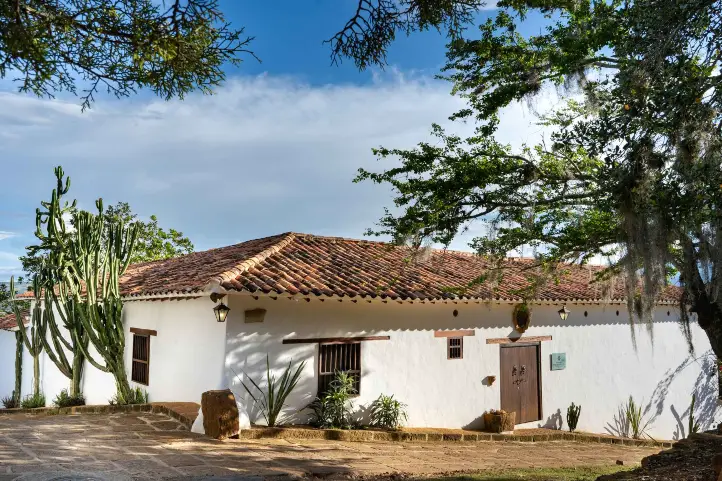
Barichara is on the list of Network of Colombian Heritage Villages, besides being one of the most beautiful villages nationwide thanks to its bohemian and colorful Andalusian style architecture.

Barichara is an excellent destination for a quiet place with a magical and photogenic atmosphere.

The town grow around the church built in 1751 on account of a supposed apparition of the Virgin. Initially it was called Vare – florence, then Vara-echada and finally Barichara, which means “Place for rest” in Guane dialect which is a derivative of Chibcha.

Barichara is built on stone. Its streets, houses, temples and especially the cemetery, a prominent place for its railings and windows, are built with yellow stone.

The cathedral of the Immaculate Conception in memory of the Virgin of the rock is a unique work, and the historic center of Barichara was declared a national monument on August 3, 1978.

In this guide you will have the necessary information to make the most of your visit in Barichara

The Diversity of Barichara

Barichara is a town in the northern Andes of Colombia with about 5,000 inhabitants. Approximately 90% of Barichara’s architecture is built by the tapia pisada technique, an ancestral procedure of building with earth, without the support of wooden pieces or any other material.

This town is located on a plateau of around 40,000-50,000 hectares, where historically there was a tropical dry forest, a type of threatened ecosystem that is in danger of disappearing from the Earth. Today, 98% of the forest is destroyed and urgently needs to be restored.

The Aquileo Parra Association – Friends of Barichara, is a non-profit organization that has the purpose of preserving the historical and touristic heritage of Barichara. It also defends the natural resources and the ecological reconstruction of the Tropical Dry Forest in the Bioparque Móncora project.

Temperatures in Barichara range between 19°C (66º F) and 28°C (82º F).

How to get to Barichara

Barichara locates in the department of Santander, 121 km from Bucaramanga capital of the department, and 350 km from Bogota, capital of Colombia.

To get to Barichara by air from the main cities of Colombia (Bogota, Barranquilla, Medellin or Cali) you must take a commercial flight to the city of Bucaramanga. Once in Bucaramanga, you take an approximately 3,5-hours ride to Barichara.

Where to stay in Barichara

Most of the hotels can be found in the historic center of town, where we recommend the following alternatives:

Panoramic view from the terrace in Casa del Presidente Hotel.
Casa del Presidente Hotel

Barichara Attractions and Activities

1. Participate in workshops

Tapia Pisada

In the Villa del Alfarero you can experience the tradition of the typical construction of the village.

You will have a conversation where you will learn about the history and recommendations on the manufacturing process, besides having a tour of the village where you will be able to build a wall of Tapia from the time of preparation of the land to the assembly of the bricks made.

Bahareque

In this workshop you will learn about the millenary indigenous technique of Bahareque, through the oral tradition inherited from the indigenous Guanes tribe, inhabitants of this region.

During the workshop you will be taken on a tour of a real Bahareque construction and be able to touch its walls, caña brava, terrones, tree root ties, Fiquetones.

After having the theoretical knowledge of the technique you can put it into practice by building part of a wall.
At the end of the workshop you will take a bath, since you will be in contact with a lot of mud. So please bring along a pair of clean clothes.

Mud and adobe tile making

In the workshop you will be teach to identify 4 types of soil (Clay, Gredosa, Fine and Sandy) required for the elaboration of the tiles.
You will visit an ancestral oven with a production capacity of 4,000 units during 60 continuous hours of combustion, day and night, where temperatures reach over 1200 degrees Celsius.

You will get an explanation from the instructors of each of the steps in the production process where you can have a contact with the clay in each of the steps until you reach the firing point.

Typical cooking

In this workshop you will be able to have a direct contact with the typical gastronomy of Barichara. You will have the opportunity to learn about the production process of the following products and interact with the raw material: Typical Barichara cookies, “Arepas de maíz pelao” (corn), Pan artesanal, Sancocho de Gallina.

2. Visit the church and chapel of Barichara

Cathedral of the Immaculate Conception of Barichara.

You will see this beautiful and unusual 18th century Spanish colonial cathedral built entirely of yellow stone. Despite being a giant cathedral for the population of the town it is a place that will amaze you from the moment you enter and if you wait to see the sunset you will marvel at the beautiful ocher tone it takes at sunset.

This cathedral is a unique work, and it is supported by 10 monolithic columns carved with 5 meters high and 70 cm wide.

Visit the chapel of Santa Barbara

You want to know a beautiful chapel of the XVII century which is the scene of many marriages in the town due to its decoration with golden leaf, with arabesque, Moors and inverted flowers; which makes it a magical atmosphere for beautiful ceremonies. It is located 4 blocks from the main park of the town.

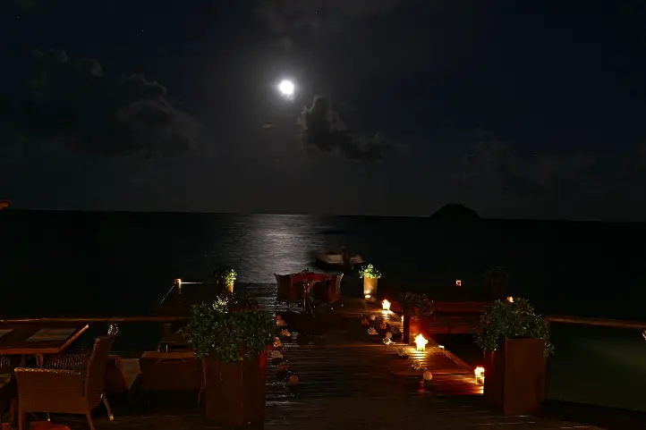
3. Visit the viewpoint of Barichara, the Salto del Mico.

Just 10 minutes walk from downtown you can enjoy a beautiful viewpoint where you will be able to appreciate the Suarez River Canyon, the Serrania de los Yariguies National Natural Park, and the municipalities of Galan, La Fuente and Zapatoca.

4. Visit the cemetery of Barichara

It is not usually one of the favorite plans of many people, but both the cemetery of Mompox and Barichara are considered one of the most beautiful in the country.

As well as all the construction of the town based on stone the cemetery is not the exception, during your tour inside the cemetery you will be able to appreciate beautiful stone carved tombstones and beautiful colonial structures.

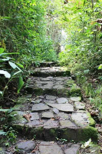
5. Hiking Barichara – Cabrera

This tour is done through the road of Via crucis in the middle of a beautiful forest to reach the municipality of Cabrera; its duration is 6 hours with a medium degree of difficulty.

Besides, there you will be able to appreciate different types of butterflies and birds, among them you can have the possibility to see the Nicéforo’s wren (Thryophilus nicefori), an endemic bird species of Santander.

6. Tobacco Tour

It is important to know that the department of Santander is considered the largest producer of tobacco in Colombia with 50% of national production.

In the rural area of Barichara it is possible to find a farm where you can take a tour for 3 hours where you can see the different processes of development of the seedling (harvesting and maturation of tobacco).

7. Trekking in Barichara

You will have the opportunity to make a trekking in the middle of the fossils and the royal stone roads during three days, having as starting point Barichara to Los Yariguíes National Natural Park.

This tour should be done during three days, has a medium degree of difficulty and a total distance covered of approximately 40 km with an average daily walking time of 5 hours.

You can visit the village of Guane until you reach Zapatoca crossing the majestic Saravita river and the Lengerke II road. From Zapatoca you will make the last trip to Los Yariguíes National Natural Park.

8. Rafting Rio Suarez

This fantastic plan has a duration of 5 hours, has 8 fast currents with unique waves in the country; you will be enjoying one of the best rivers to develop this activity. Keep in mind that this activity can only be done by people over 18 years old.

9. Horseback riding

You can make horseback riding tours throughout the day, starting at 5:00 a.m. to appreciate the sunrise or at the last hour at 6:00 p.m.

The cobblestone streets and beautiful landscapes will accompany you on your tours and with the support of the guides you will learn more about this treasure of Colombia.

Thanks to the proximity between San Gil and Barichara of only 32 km you can choose to enjoy a full day of adventure activities that San Gil offers, and then at night return to Barichara.

For more information about the activities and everything you need to know about San Gil visit The Adventure’s and Extreme Sports’ Capital of Colombia: San Gil.

References
Luisa Martin

Engineer, world traveler, amateur photographer, traveling blogger, and foody.


The 7 Most Beautiful Places to Go Stargazing in Colombia


In Colombia, you can experience the unique and rare emotion of stargazing. The whole country offers the conditions to make astronomical tourism throughout the year, from the Andes to the Caribbean Sea.

Before telling you which are the best stargazing spots in Colombia, based on tourism facilities and beauty, I will promptly mention some topics of special attention.

The Light Pollution Menace

Sadly, almost a third of humanity cannot see the Milky Way when they look at the sky at night.

There are many sources of light on Earth that emit light particles into the atmosphere, causing the skies to become hazy.

Today there is more awareness of this phenomenon, and more people are mobilizing to promote the use of cleaner light installations.

Light Pollution Map, Colombia – Powered by https://lighttrends.lightpollutionmap.info/

Effects of excessive light

According to the NGO Globe at Night, the light-dark cycle, when interrupted, affects ecological dynamics, and is a serious threat to nocturnal wildlife in particular.

Light pollution can also lead to sleep disorders and other health problems. In addition, health effects are not only due to over-illumination or excessive exposure to light over time.These are also produced by inadequate spectral composition of light (e.g., excessive blue light from cellphones).

With regard to energy waste, over-illumination can be a waste of energy, especially at night. Therefore, it generates increases in costs and carbon footprint.

Light pollution Hong Kong ©Science Magazine

What to do?

Nevertheless, the NGO Globe at Night explains that light pollution can easily be reduced by doing simple things like:

  • protecting the lights properly so that the light does not go up,
  • only using light when and where it is needed,
  • use only the amount needed,
  • install low energy bulbs, and
  • choose bulbs with spectral power distributions appropriate to the task at hand.

Astrotourism is also a way to protect the night sky from increasing light pollution. It works through the recognition and protection of areas that still have low or no light pollution.

Astrotourism or Stargazing

Let’s start with some basic tips.

Basic Tips for an Amazing Stargazing Night

Before going out for stargazing consider the following points:

1.Weather

Try to find the most accurate information about wind speed, wind pressure, cloud forecast, and temperature. Atmospheric pressure is also something important to check. The higher the pressure, the clearer the conditions.

2. Transparency

Dust or moisture ruin the fun of the stargazes since they make the skies hazy. Try to find the best season, which in Colombia, means avoiding the rainy season. But also, going to the driest regions and the higher places.

3. “Seeing”

The later you go out, the better sight.  I found an interesting paper in Science Magazine you can read later. It talks about a light pollution tracking tool ideated by a physicist. With this tool you can check whether the night sky is getting brighter. It is called the Radiance Light Trends Website.

4. High Spot

It can be a mountain or a building. This will help avoid light pollution effects.

5. The Moon

The Gibbous or crescent phase of the moon is best for stargazing. A brilliant moon will overshadow the stars and planets.

6. Prepare for the night

  • Dress appropriately for the weather
  • Let your eyes relax and enter into dark adaptation
  • Avoid devices with white light, astronomers recommend using devices with the red light option.
  • Bug spray, needless to explain, but worth recalling, especially in Colombia, where it is always summery.

Best Stargazing Spots in Colombia

Any place without light pollution is a good place to see the stars. Colombia has many places that offer beautiful starred and cleaned skies, far from the contamination of the cities. However, not all the places offer the appropiate tourism facilities.

Here I will list the best stargazing spots in Colombia, based on tourism facilities and beauty.

Tatacoa Desert

Night at the Tatacoa Desert ©Bernardo Solano

The most recommended destination for astrotourism is the Tatacoa Desert in Huila. This is the only destination in Colombia with a Starlight Certificate, nominated in 2019. 

Besides its intrinsic desertic beauty, it makes you feel like observing the stars from mars, or the moon. The ochre and grayish tones of its landscapes contrast with the clear sky.

The desert has very low light contamination, and it has three different astronomic observatories, with telescopes, which are open to the public offering educational activities and nocturnal expeditions.

The epicenter of astronomical tourism in this region is the municipality of Villavieja, in Huila, where the Tatacoa Astronomical Observatory is located. In this place, visitors can participate in talks about astronomy and see the stars through the astronomical telescope.

Additionally, in the month of August you can witness the ‘Rain of the Perseids’, a beautiful stellar spectacle in which you can see up to 200 stars per hour.

Where to stay: Yararaka Hotel Boutique

Villa de Leyva

Night at Villa de Leyva – Facetas Boyacá

Also a good place for astrotourism is this beautiful town in Boyacá. Every year Villa de Leyva is the meeting point for the amateur astronomers. They gather for their annual meeting, the Astronomy Festival, which is the most important amateur event in Latin America.

Villa de Leyva features a high elevation and a dry environment, which also facilitates the observation.

It also has a very good infrastructure to receive tourists.

Where to stay: La Posada de San Antonio Hotel

Barichara

Casa del Presidente – Barichara

This town is located in Santander. It is also a destination with very good infrastructure and also it offers ideal conditions to watch the sky, because of its dry environment.

Where to stay: Casa del Presidente.

Cabo de la Vela

Full Moon at Cabo de la vela

La Guajira is a magical place in Colombia. It is another desertic area, but placed in the Caribbean region. Cabo de la Vela, in the northern territory of Guajira, also offers a very good infrastructure for tourism, and also clean and dark skies.

Here you will hear the sea waves and learn more about the mysteries of the universe from the Wayúu community.

In Cabo de la Vela, the desert landscape merges with the sea, and the night skies are filled with shooting stars and constellations, thanks to the absence of artificial lighting from nearby towns.

In addition, if you love nature, take a visit to the Flamingo Sanctuary or a tour of the Taroa Dunes are good extras.

Where to stay: Ranchería Utta.

Lagos de Menegua

Astrotourism in Lagos de Menegua ©Lagos de Menegua

The Lagos de Menegua Bioreserve is one of the few privileged places that still have black skies. Its privileged location allows simultaneous observation of the northern and southern hemispheres.

The reserve has a calendar of astronomical events with free registration. It also offers this activity exclusively for companies and specific groups.

Between the months of December and March, the probability of 100% clear skies increases, making the best time to visit.

Where to stay: Lagos de Menegua.

Cocuy National Natural Park, Boyacá

The Milky Way observed at El Cocuy NNP ©Rodrigo Bernal Díaz

After 9 pm, on a very clear night at 4,444 meters above sea level, on the shores of La Laguna Grande in the Sierra in El Cocuy Natural Park (Colombia), the Milky Way rises behind the mountain. The cold can get to your bones, but the view is wonderful.

Rodrigo Bernal Diaz

This national natural park, located in the center-east of the country, on the border between the departments of Boyacá and Arauca, is another of Colombia’s tourist sites where people can experience an unforgettable night looking at the stars. Of course, if you don’t mind to camp.

In fact, the U’wa Indians of the Sierra Nevada del Cocuy created the Astronomical Observatory on the ancestral Camino de Mal Paso. In this place tourists can marvel at the spectacular clear nights and see the stars, and, at the same time, interact with the U’wa community.

Where to stay: Camping zone.

Suesca and Tominé near to Bogotá

Niddo – Suesca

Near to Bogotá are the town of Suesca and the Tominé reservoir. All this region has a very good tourism infrastructure and also, they have altitude, with more than 2500 meter above sea level.

Altitude is fundamental because there are fewer atmosphere layers above you, so you are nearer to the sky.

Where to stay: Glamping* Niddo

If you want to know more about the most incredible natural destinations in Colombia, plan your trip with us!

*Find more information about Glamping in Colombia in the post The 32 Most Beautiful Glampings in Colombia You Should Know, at Pelecanus website.

References
About the author

Sara Colmenares

Current director of Sula. Doctor in Biological Sciences. Her main interests are to explore and understand the organism – environment interactions, taking advantage of emerging knowledge for the management and conservation of species and ecosystem services. She is currently working as a consultant in functional ecology, ecosystem services and conservation projects in Colombia related to ecotourism and birdwatching.


Historic Royal Roads of Colombia: New trekking Destinations

Historic roads are routes that have great historical importance. Nowadays they are becoming interesting destinations for trekking in Colombia.

They exist from the prehistoric era and the first ones were supposedly traced by animals and then adapted by humans. They were usually for trade and communication throughout big empires.

Famous Historic Roads

Some of the most representative and largest historic roads are the following:

  • Silk Road: trade routes that connected the East and West from the 2nd century BCE to the 18th century, specifically East, South and Southeast Asia with Persia, the Arabian Peninsula, East Africa and Southern Europe.
  • Amber Road: amber trade route from the coastal areas of the North Sean and the Baltic Sea to the Mediterranean Sea.
  • Royal Road: highway rebuilt by the Persian king Darius the Great in the 5th century BCE for facilitating rapid communication throughout the Persian Empire.
  • Post Track: causeway in the valley of the River Brue in the Somerset Levels, England that dates back to 3.838 BCE.
  • Red River Trails: network of ox cart routes between Canada and the US, from the 19th century.
  • Inca road system: the most extensive and advanced transportation system in pre-Columbian South America. It was about 39,900 kilometers (24,800 mi) long and the most famous section is the Inca trail to Machu Picchu.

Nowadays, some historic roads have been the target of preservation efforts and, thus, adapted to tourism. One of the best examples is the Appalachian Trail.

Appalachian Trail

Appalachian Trail ©https.appalachiantrail.org

Proposed in 1921 and built in the following years, this trekking trail is 3,500 km (2,200 mi) long and goes from north to south in the Eastern United States.

Thousands of hikers attempt to travel the whole trail, but only 1/4 achieve it and are called ‘thru-hikers’.

The Appalachian Trail boasts a natural and cultural heritage, and for this reason, the Appalachian Trail Conservancy was created, to ensure this unique place is well-managed and preserved.

In 1991, an International Appalachian Trail was created, which continues northeast from the US state of Maine to Canada and then, sections in Greenland, Europe and Morocco were founded.

Royal Roads in Colombia 

Historic roads were essential in the formation process of Colombia, since they allowed not only product exchange but culture and knowledge exchanges. In this way, the former isolated villages were becoming a network, a community, that offered tons of new opportunities.

Geography and population distribution throughout the country set a huge barrier for communication between the different settlements, so the ancient trails traced by native cultures have an incalculable value until today.  

Transport roads between the Spanish mines in 1560. ©Monique Lepage

The Need to Connect the Country

Although the first routes were opened by indigenous communities amid dense forests and steep mountains for religious and cultural reasons, the Spanish conquerors were the ones who forced the integration of national territory.

Most urban centers were established far from the coasts as the largest indigenous groups lived in inland areas. Coastal towns had easier communication with Europe than with the capital and other inland territories, so the need for a transportation axis across the country was evident.  

Navigating the Magdalena River by Steamship, 1868 ©CC Leibniz-Institut für Länderkunde e.V., Leipzig

The Magdalena river was the axis to which several of the main hinterland roads converged, the royal roads.

Since the Spanish settlers sought to open new routes that helped the subjugation of the indigenous and the territorial integration, subsidies and benefits were offered to those who succeeded in opening crucial roads.

Later, from 1880 to 1930 the royal roads had their boom and transported volume of cargo and were traversed by travelers and mules as never before.

Since 1930, the bridle paths that allowed the inter-communication in Colombia experienced a crisis due to the introduction of wheel-friendly roads.   

Royal Roads as Destinations for Trekking in Colombia

Nearly 80 years later, in 2008, Colombia’s Ministry of Culture launched the first project of cultural tourism in the country, which was about redesigning and reopening 3 routes of Royal Roads and was called ‘Recovery of Colombia’s Royal Roads‘.

The program aimed to analyze several variables of existing royal roads to determine its viability as cultural tourist attractions. The first royal road to be studied was the one located between Guaduas and Honda, which is 33 km long 

What motivated to undertake this project was the belief that “we must know, cherish and recover the Royal Roads, because they are essential parts of our memory and guiding threads to the future”, according to the then Ministry of Culture representative.  

Now, these are the Colombian royal roads that are currently open for tourism. Check out some of our tours here!

Lengerke’s Royal Road  

Some of the most beautiful colonial villages in Santander are connected by bridle paths built in the 19th century.

Geo von Lengerke, a German engineer, was the mastermind of these multiple roads that served to explore new territories and boost regional trade to and from the Caribbean coast along the Magdalena river.

Although the roads were planned by a foreigner, the construction was in charge of local labor. These represent a great architectural landmark, taking into account the complex topography of this region in northeastern Colombia. However, it has to be mentioned that the Guanes and Yariguies indigenous communities would have traced and traveled the roads before. 

It is estimated that there are 800 to 1,300 km of roads with different conservation status, roads that demand a good physical condition since the trek is of intermediate to high difficulty. 

The roads that helped the local economy thrive over 150 years ago, today keep their function, but in the tourism sector: they are favorite attractions among tourists visiting Santander.

One of the reasons is the big role that nature plays in beautifying the trek that passes by some of the best preserved villages of the region.

Itinerary of the trip along Lengerke’s roads

Barichara

The Lengerke’s royal roads are full of amazing viewpoints and a background that helps tourists connect with Colombia’s history and development, while enjoying nature. This is the itinerary of the trip along Lengerke’s roads: 

First Stop. The journey starts in Mesa de los Santos, a warm municipality that offers extreme sports facilities and a renowned organic coffee.  

Second Stop. Jordan is the next stop, reached after descending by the breathtaking scenery of the Chicamocha Canyon, which takes about 3 hours. Jordan connected the southern municipalities with Bucaramanga, Santander’s capital, so it was of high importance. There it is safe to camp and rest before continuing toBarichara 

Third Stop. The colonial village of Barichara was declared a World Heritage Site in 1978, since it keeps its classic infrastructure of narrow streets, white walls and yellow ground, which gives its inhabitants the nickname of ‘patiamarillos’ or the yellow-legged. Barichara has various cultural attractions you can visit during your stop. 

Fourth Stop. The journey goes on to Guane, a small village that was the most important chiefdom for Guane indigenous community during the pre-Columbian era. Its church, Santa Lucía, is a National Monument.  

Five Stop. The last leg of the trip is from Guane to Zapatoca, the town where Lengerke lived his last years. There is a great ecotourism offer in this place, including vineyards, the Nitro’s cave, La Lajita waterfall and the Azul and Ahogado wells.  

Honda – Santa Fe Royal Road 

This is the most representative historic road of those built during the colonial era. Starting from Honda, a commercial port by the Magdalena river, and passing by the villages of Mariquita, Villa de Guaduas, Chinauta, Villeta and Facatativa, it ended Bogota (formerly called Santa Fe de Bogota). 

In colonial times, the Magdalena river was navigable up to Honda. The Spaniards made the town a starting point to travel to the center of Colombia.

The royal road, built by slave labor in the 16th century, was very rustic, considering the difficult terrain: it went up and down, went along mountains, valleys, rivers, small villages and unexplored land.

Despite that, everyone who wanted to get to Bogota, had to go through this route, the main communication path in the kingdom of Nueva Granada. 

It was about 112 km long and most of it was between mountains, the rest was located in the Bogota savanna. Travelers completed the route in 6 days or less in the summer; however, during the winter, they could take twice.  

José Celestino Mutis

The ‘Mutis Route’

The first route for cultural tourism was created to celebrate the 200th anniversary of the death of Jose Celestino Mutis. It is called ‘Mutis Route‘ and includes the most important towns where this wise botanist passed by during his famous ‘Botanical expedition‘, i.e the ones that formed the Honda royal road.

Its goal is the appropriation and recovery of the artistic, cultural and historical wealth of the villages, while generating income for the improvement of their life quality.

It has nearly 300 km from Bogota to Ibague and its paths can take between 2 and 7 days of traveling. 

Itinerary of the trip along the Mutis Route

Some of the villages that are privileged to have a section of the royal road are focusing on its preservation and offer guided tours down the road. 

Mariquita

In Tolima, this town was a key transit point in the royal road, that witnessed not only valuable goods but news about new scientific discoveries and ideas.

It was the headquarters of the Royal Botanical Expedition from 1783 to 1791, when it moved to Bogota. 

Honda 

It is in northern Tolima and became the main connection of the hinterlands with Cartagena and, from there, with Spain.

During the 18th century, its royal road had its boom, which lasted until the 20th century.  Today, Honda is one of the Heritage towns of Colombia, thanks to its historical legacy.

Guaduas 


This town is known to be the home town of Policarpa Salavarrieta, the heroine of Colombia’s independence, but before that, it was a key place in the route between Honda and Santa Fe de Bogota.

From the Capira Stone viewpoint, you can see the stunning  Magdalena river valley and a section of the ancient Royal Road that leads to the capital of the country.

A civil society organization, along with young students, is in charge of maintaining the path for visitors to enjoy the travel along it.  

La Mesa 
Camino Real – Mutis Route, Tena, Cundinamarca,

La Mesa is a municipality in Cundinamarca situated on a plateau at 1,200 MASL and also played an important role in the road system of the hinterlands, serving as a mountain port. 

It was a node of a network of several roads that came from nearby regions such as the Bogota savanna, the Magdalena valley and Tequendama.

Some of these stone paths have been preserved to this day, for example, the royal road to San Javier or ‘Camino del Resbalón’. Although short, this road is a fantastic work that is only disrupted by some paved crossroads. 

References
About the author.

Ana María Parra

Modern Languages professional with emphasis on business translation. Interested in cultural adaptation of written and audiovisual content.  Passionate about knowing new cultures and languages, tourism and sustainable living.