Pijao is a quiet and unexplored natural destination, and the first Cittaslow town in Colombia. A Cittaslow town is a community-managed system of continuous improvement with a sustainable outcome that strives for quality of life for its residents.
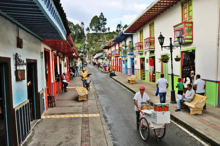
Pijao is a town with a coffee architecture tradition that stopped in time, as well as the church clock, with a long tower and with little grace, painted in pale orange that stopped at 7:25 minutes, one day, many years ago.
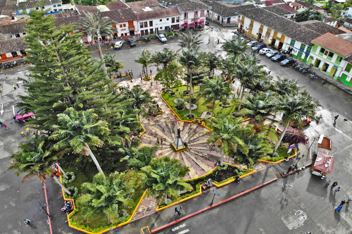
Discovering Pijao Cittaslow
It is located in the west of the department of Quindio on the central mountain range at 1700 meters above sea level, and has no more than 6,800 inhabitants.
At the village entrance there is an arch of raw brick columns with a chipped statue of Virgin Mary; when you are in the center of the village you will notice that the people live without worries.
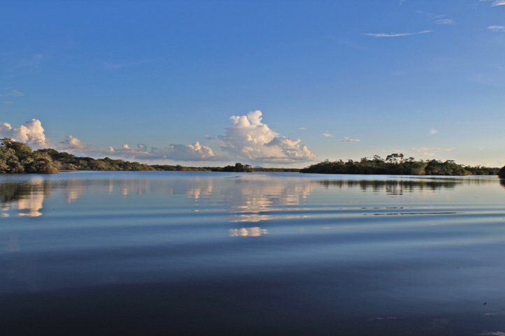
In addition, Pijao has a high Andean forest ecosystem and Páramo; in the Páramo the rivers Lejos and Azul are the source of the town’s water supply and its average temperature is 23°C (73º F).
How to get to Pijao
Take a 1,5-hours flight from El Dorado (BOG) in Bogotá to El Edén International Airport (AXM) at Armenía city. Once at the airport, take an approximately 1-hour ride to Pijao
Where to stay in Pijao
When in Pijao you will feel part of the town, as the facades of the hotels are very traditional and you will feel like you are in another era. There are few lodging options and we recommend you to stay at Finca el Otoño.
Activities and attractions in Pijao Cittaslow
Tour of the town
We recommend that you start your tour in the central park, from there you can have a panoramic view of the houses where you will fall in love with its beautiful architecture and colors.
Then you can visit the town hall which looks like an anthropological museum, in fact, it is in a way.
Moreover, you can visit the church of San Jose which has a very particular structure, the colors contrast with the architecture of the square and its clock tower preserves the original structure.
La Floresta Coffee Shop
This cozy coffee shop despite its humble appearance has a space where you can live a wonderful coffee experience; where you can learn the methods of filtering and preparation. They gave us a live demonstration of the chemex method and we did a tasting of different types of coffee, both hot and cold.
Bar Los Recuerdos
The owner of this bar, Gonzalo, over the last 50 years has collected about 3,000 photographs and posters of Argentine, Spanish, Colombian and Mexican artists, which adorn the walls and ceilings of this magical place.
Inside the bar you can observe the collection of more than 2,000 vinyl records of boleros, rancheras, pasillos and tangos, which play in a 33 and 45 revolutions player.
Pijao Social Bar
Enjoy a delicious cup of coffee in the only steam-powered ink machine in Quindío that is more than 70 years old. While enjoying your coffee you can play pool with the locals and listen to the anecdotes of this historic bar.
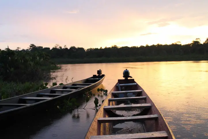
Contemplate the sunset in “the place where the herons arrive”
Just 20 meters from the central square you will find a tree where every day hundreds of herons and other birds come to rest, including those flying away from the North American winter.
Mountain biking through the Paramo de Chili
If you have previous experience in mountain biking you will love this activity, 28 kilometers of biking from Pijao you can live a unique and unforgettable experience where you will overcome your limits until you reach 3,750 meters above sea level.
This tour has a duration of 7 hours and its degree of difficulty is high.
Excursion to the Mellizas Lagoon
If you want to know a hidden place of Los Nevados Natural Park, if you like trekking and hiking this plan is for you. During 6 hours of hiking with a medium-low degree of difficulty in the middle of swampy paths but of special beauty.
During the tour you will be able to observe a great diversity of birds, trout and frailejones and discover 7 additional lagoons that are little known by the visitors of the Natural Park of Los Nevados.
Coffee Experience
In the rural zone of Pijao it is possible to take tours of the coffee plantations. You will have a tour of the coffee process from the beginning, exploring from the coffee plantations to the coffee roasting and grinding process.
Finally, you will be able to enjoy a delicious cup of high-quality coffee, due to the soil conditions and the processes that the farmers of the town manage.
Tour to the Wax Palm Forest
Initially you must have a local guide to carry-out this activity. The first trail you take goes to the farm La Playa, where you can have breakfast and from there you will reach the school of Vereda Las Palmas. his point can be reached by motorcycle, jeep or bike before starting the ascent on foot.
During 40 minutes of walking at more than 3200 meters above sea level you will be surrounded by the imposing and beautiful wax palms, until you reach the farm El Alto. There you can have a hot snack or lunch while you contemplate the beauty of the mountains decorated by the enormous amount of wax palms.
It is recommended that you wear warm and waterproof clothes, if possible bring a change of clothes in case of rain.
If you want to know more about Colombia, or wants to book your trip, please contact us.
Lorica or Santa Cruz de Lorica, is a heritage town of Colombia located on the banks of the Sinú River, bathed by the Ciénaga Grande del bajo Sinú, in the department of Córdoba. It has an enormous cultural value, both for the influence of the Sinu River and the different groups that have inhabited the region.
This town of Lorica receives several names such as the Ciudad Antigua y Señorial (i.e., Ancient and Lordly City), the Capital of Bajo Sinú, the Capital of Bocachico and even as Saudi Lorica, as a result of the arrival of Lebanese immigrants in the late nineteenth century.
Santa Cruz de Lorica is known by both its architectural majesty and by its gastronomy. Regarding gastronomy, the Bocachico fish is an elemental ingredient of typical dishes such as Bocachico Sinuano and Sancocho de Bocachico.
Besides, since the end of the XIX century and the beginning of the XX century, Lorica stood out as one of the great fluvial ports of the country. If you visit this town, we recommend you to visit the banks of the Sinu River, for a magical walk.
Below you will receive the necessary information you need to make the most of your wonderful visit to Santa Cruz de Lorica.
Heritage town of Colombia since 2010
The Land of Mixed Waters
Lorica was founded in 1740, and its historic center presents a mixture of Republican and Arabian styles, offering a beautiful spectacle to those who visit it. For its architectural beauty it was declared a National Monument in 1996.
In Lorica you can find beautiful places that transport the tourist to the Middle East, such as the Municipal Palace, the Cathedral and the Afife Matuk Building.
An emblematic place of Lorica, on the banks of the Sinu River, is its market square, also called the Ranchon, which not only offers the best of local cuisine, very varied indeed.
Lorica’s Jewels of architecture
Its architecture combines a style that merges the Republican with the vernacular and Mudejar, a mixture of Andalusian and Arabic constructions. This place is a faithful exponent of a cultural legacy that shows the dynamics of the mid-twentieth century, product of the heyday of activities such as navigation and trade.
Its great architectural constructions are the legacy of some foreign settlers who imposed a unique stamp that has been maintained over the years. In fact, Syrian-Lebanese immigrants who, with the desire to build their own properties, gave shape to their culture and marked the identity of this region.
Sustainable Destination
In 2020, with support from FONTUR, the Historic Center of the municipality of Santa Cruz de Lorica was certified as a Sustainable Tourism Destination, after meeting the requirements of the Sustainable Tourism Sector Technical Standard NTS TS-001-1.
This represents a tool for the promotion and strengthening of the tourism sector in the destination, which allows to offer all visitors a quality tourism, generating confidence and satisfaction when walking the streets of this magical municipality.
Exploring Santa Cruz de Lórica
Santa Cruz de Lorica is on the list of “Network of Colombian Heritage Villages” a place full of history and culture. Lorica has a unique architecture between Republican and Lebanese, so it is charming to walk through its streets.
This town is located in the department of Córdoba, 60 km from Montería. It is recognized as the treasure of the Caribbean, for its important fluvial artery which is the Sinu River.
Bear in mind, the average temperature in Santa Cruz de Lórica is between 23 ºC (73ºF) to 35 ºC (95 ºF) and the best time of the year to visit Lórica is from mid-December to the end of March.
How to get to Santa Cruz de Lórica
Lorica that is located in the department of Córdoba, 63 kilometers from Montería and 55 from Sincelejo. There are two airports near to city you can arrive traveling from Bogota.
Bogotá – Monteria – Santa Cruz de Lórica
Take a 1,5-hours flight from El Dorado (BOG) in Bogotá to Los Garzones International Airport (MTR) at Monteria city. Once at in Monteria you take an approximately 1,5-hours ride (61 Km) to Santa Cruz de Lórica.
Bogotá – Tolú – Santa Cruz de Lórica
Take a 1.5 hour flight from El Dorado (BOG) in Bogotá to Golfo de Morrosquillo Airport (TLU) in the city of Tolú, with ADA Airlines. Once in Tolú, it takes approximately 35-minutes (30 km) to Santa Cruz de Lórica.
Where to stay in Santa Cruz de Lórica
In Santa Cruz de Lórica you can find hostels and hotels that preserve the local architecture, we recommend Hotel Boutique Beteska and Onoma Hotel.
Santa Cruz de Lórica Attractions and Activities
Historical Center
The most striking attraction with eclectic buildings of Arabic influence and similar to those found in the city of Cartagena. Their fine elements and details make them imposing.
Public Market
Built in 1929, this building of republican architecture with certain Arabian touches, covers an entire block of the historic center, located on the banks of the Sinu River. Due to its importance and uniqueness, the Government, in 1996, named it a national monument.
Parish of Santa Cruz de Lorica
Built before 1800, and had to be remodeled in 1896. An important fact for when you visit this parish is that its bells were brought from Portugal, the bronze images of the facade are of French origin, and the clock, brought from Italy, was donated by the Syrian-Lebanese colony around 1929.
Gonzalez Building
It was owned by one of the wealthiest families in the region. It has an area of 540 square meters and it displays a republican style which highlights the facade and its internal spaces. You can take beautiful pictures in this imposing building.
Lorica Club
It is located in a corner of the Plaza de la Cruz, formerly where the Syrian-Lebanese immigrants organized their social gatherings. Nowadays it is open to the population where nightly events are held.
Afife Matuk Building
Placed on the banks of the Sinu River and adjacent to the public market. This building was finished in 1929, and it remains intact to date. Inside, you will notice how the light blue and white colors stand out in small walls that separate each space, with arabesque figures. It also has a room with a large window where you can see the waters of the Sinu River.
The Malecon of Lorica
It is the complement of the patrimonial buildings of the Historical Center and the Public Market, it has an extension of 5 km around the banks of the Sinu River. It was declared of Cultural Interest in 1998; during your walk you will be able to appreciate the beauty of the river and the beautiful buildings.
Gastronomic delights in Lorica
Immigrants played an important role in Lorica’s gastronomy, so it is possible to enjoy very typical dishes of the region such as bocachico stew, the popular sarapa, mote de queso (whose main ingredient is Creole yam and coastal cheese) and food such as kibbes (prepared with ground beef, wheat, onion, mint, salt and pepper) that characterizes the immigrant culture.
Craft traditions in Lorica
In Lorica, primitivist painting is its maximum artistic expression. It reflects the popular imagination, dishes, objects and colors of the peasant culture. Its main exponent was Marcial Alegría Garcés, a man who dedicate himself to painting. Marcial’s paintings are present in more than 18 countries, becoming one of the emblems of Lorica’s art and tradition. You will appreciate his history and works in the village of San Sebastian. Marcial also applies his art to ornate pottery pieces that are made and sold there, as well as canvas paintings and wooden frames.
Nature Destinations Near Lorica
Lorica is surrounded by a complex landscape of swamps and marshes mixed with pastures with extensive cattle ranching and patches of flooded forests. The area is very susceptible to water level variations in the marshes and the Sinú River as a result of seasonal changes in rainfall. The main habitats in the region are swamps and marshes.
Visit the Nearby Marshes and Natural Reserves
34 km from the town you can visit the swamp of La Caimanera, with 2000 hectares of mangroves, herons and reptiles. it is possible to kayak and canoe along the river.
There is also La Leche swamp, ideal to see monkeys, snakes, tigers and deer. Finally, the Sanguaré Natural Reserve, with 110 hectares of tropical dry forest surrounded by mangroves, coastal freshwater lagoons, sea grasses and reefs.
Ciénaga Grande de Lorica is another big swamp, which is home to numerous species of birds, mammals, fish and reptiles. It is shared by five municipalities and fed by lagoons and streams and the Sinu River. It has an extension of more than thirty thousand kilometers, and it is home to the Blue-winged Teal (Anas discors) when they arrive from Alaska.
Swamp complex of the western margin of the Sinú River
This region was declared Important Bird and Biodiversity Area (IBA). Despite conservation efforts, the land is mainly used for extensive cattle ranching and fishing, subsistence agriculture and timber extraction. From 1997 to 2002 a project on sustainable use of wildlife was developed in the Bañó swamp, where a community-based tourism program was key. However, the place has no the expected recognition as an ecotourism destination.
Birdwatching
Bañó marsh alone registers a total of 142 species of birds. However, the number of species may be higher, as many marshes remain uninventoried.
There are large flocks of Fulvous whistling duck (Dendrocygna bicolor), Black-bellied whistling duck (D. autumnalis), White-faced whistling duck (D. viduata) and a large number of waterfowl in general. The area is potentially important for reproduction and long-term maintenance of the Northern screamer (Chauna chavaria) population, as well as five other species of ducks. More than 20,000 waterbirds congregate there.
Other fauna
Besides birds, it is possible to find some threatened fauna species such as Neotropical otter (Lontra longicaudis) (DD), Gray-bellied night monkey (Aotus lemurinus griseimembra) (VU), Dahl’s toad-headed turtle (Phrynops dahli) (CR), Magdalena River turtle (Podocnemis lewyana) (EN), Hicotea (Trachemys scripta callirostris) (LR/nt). Two characteristic species of flora are: Pithecellobium lanceolatum and Thalia angustifolia.
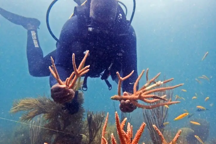
Diving
There are more than 17 dive sites where you can admire the largest variety of virgin corals in the Caribbean, nurse and whitetip sharks, turtles, fire and brain corals. It stands out Bajo Bushnell, a reef where barracudas, giant gorgonians and horn coral colonies abound. Other interesting diving places are: Burbujas, Los Pargos, Grieta del Socorro, Fondo Loco, Bajo Mariajo, Los Venados, Los Bayones. Moreover, for advanced divers, Bartolo reef and El Orion.
Beatiful Beaches of Coveñas and Tolu
Thanks to its proximity you can visit Coveñas and Tolú. To get to Coveñas you must take a 45-minute (30 km) road trip. There you will be able to develop the following activities:
Relaxing at the beaches of Coveñas
The beaches you can visit in Coveñas are La Coquerita and Punta de Piedra. You can practice activities and sports such as jet skiing, scuba diving, donut riding, jet skiing, among others.
Marine Infantry Museum Park
It is a museum that has a very attractive architecture, where the work of the armed forces is exhibited as well as part of the history of the country. You can enjoy 22 exhibition rooms and other spaces where the history of the Colombian infantry is shown from independence to the present.
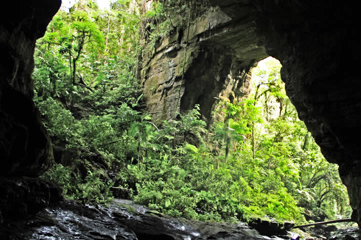
There are 7 caverns where you can go spelunking and explore the mysteries hidden inside, also formed by millenary formations of stalactites, stalagmites and dolomites in its depths, dating from the Miocene and Pliocene periods.
If you want to plan your trip to Colombia do not hesitate to contact us, visit our Plan your trip page!
BirdLife International (2021) Important Bird Areas factsheet: Complejo cenagoso de la margen occidental del Río Sinú. Downloaded from http://www.birdlife.org on 13/09/2021.
About the Authors
Sara Colmenares
The current director of Sula. Doctor in Biological Sciences. Her main interests are to explore and understand the organism-environment interactions, taking advantage of emerging knowledge for the management and conservation of species and ecosystem services. She is currently working as a consultant in functional ecology, ecosystem services, and conservation projects in Colombia related to ecotourism and birdwatching.
Luisa Martin
Engineer, world traveler, amateur photographer, traveling blogger, and foody.
The Sunflower (Helianthus annuus, the common sunflower) is worldwide known for its beauty and Vincent van Gogh paintings. The blooming of this beautiful flowers everywhere attracts many people to the so-called sunflower tourism.
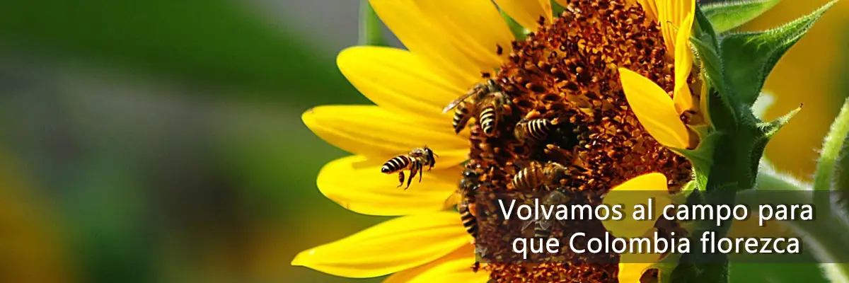
Although they are treated as weeds, they fulfill an important function: their ability to grow in all types of environments and their resistance to drought allows them to invade degraded sites, where they detain the soil. Also, because they produce a lot of nectar, they attract numerous pollinators, such as bees.
Origin of Sunflowers
Indigenous domestication
Sunflowers were domesticated by Mesoamerican Indian tribes, and are traditionally associated with pre-Columbian Mexican cultures. They were cultivated more for their usefulness than for their beauty.
However, the sunflower was used as a symbol representing the sun deity, primarily by the Aztecs and Otomies in Mexico and the Incas in Peru.
In 1532, Francisco Pizarro entered Peru, where he found a gigantic sunflower that the indigenous people of the Inca empire worshipped as a sacred image of the sun god. Then, gold figures of this flower, as well as seeds, were taken to Europe at the beginning of the 16th century.
Crops and Sunflower Tourism
Nowadays, their cultivation for oil extraction has been widespread in Spain since about 1980, thanks to subsidies from the European Economic Community. The same happens in the United Stated.
However, this is not the only appeal of sunflowers; the beauty of their fields attracts millions of tourists around the world.
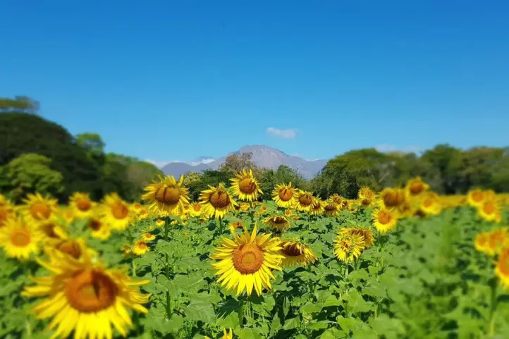
Today there are sunflower fields on every continent, but the sunflower fields in Spain and Italy are the most famous for their unparalleled beauty.
The most beautiful sunflower fields in Spain are those found in the regions of La Bureba in Burgos, Cardejón in Soria, Carmona in Seville and Antequera in Malaga.
On the other hand, the most famous sunflower field in Italy is in the Tuscany region.
Sunflower Movement
Every day, sunflowers move towards the sun, following it on its east-west route. At night they move in the opposite direction, as if waiting for the sun to rise the next morning.
But one day they stop doing so, since when they reach maturity they stop their dance, do not turn again and remain oriented indefinitely towards the east until they die.
This movement, called heliotropism, is regulated by the circadian rhythm of the plants, and favors their growth.
And the truth is, it is not the flower that turns, it is the uneven growth of its stems that causes the turning. And when they stop growing, they stop turning.
That they stop is not entirely sad, since when they reach maturity, the plant is ready to be pollinated. The flowers release additional heat, which makes them more attractive to pollinating insects.
Find out more in the Science ReportCircadian regulation of sunflower heliotropism, floral orientation, and pollinator visits: Sun-tracking when young, east-facing when mature, warmer sunflowers attract more pollinators.
Sunflower Tourism in Colombia
Research on sunflower cultivation in Colombia has been carried out since the late 1950s. But it was not until 1985 that the first sunflower field was planted for commercial production. The first crops were planted in Valle del Cauca, Tolima and Cesar.
In general, sunflower grows well in Colombia, from sea level to 2600 meter above sea level, so much so that today there are crops in Bogota. However, it was not until 2020 that some fields began to be used for tourism.
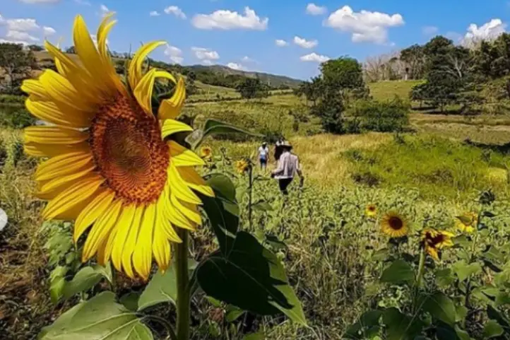
Today, there are several destinations where you can visit sunflower fields in Colombia, bu today I am goiong to talk about the most suitable for visit: San Martin, in the department of Meta, in the eastern plains of Colombia, Montes de Maria in the department of Bolivar, in the Colombian Caribbean region, and Valledupar in the department of Cesar, also part of the Caribbean region.
Sunflower Tourism in San Martin, Meta
Sunflower Tourism in San Martin de Los Llanos, Meta, Colombia CC @campodegirasolessm
The municipality of San Martin de los Llanos is located one hour from Villavicencio, capital of Meta. The annual sowing of sunflowers in a private plot of land in San Martín de los Llanos is the place that delights the visitor’s eyes with a minefield of this plant.
For more than five years, between the months of October and November, the sunflower crop blooms, and every year tourists are treated to the experience of walking among a crop of large and impressive sunflowers.
The tour starts at 10:00 in the morning or at 3:00 in the afternoon, from the municipality of San Martin with the indications of the authorized guides.
To get there you have to cross a 3-kilometer dirt road from San Martin; since it is private land, it is not permitted to indicate the exact location of the place.
Sunflower Tourism in Montes de María (or Serranía de San Jacinto), Bolívar
Sunflowers in San Jacinto, Bolivar, Colombia. Pic. by @yulart__
Between the departments of Bolívar and Sucre, in the Colombian Caribbean, is located the sub-region of Montes de María, a vast territory of agricultural and livestock tradition whose geographical location consolidated it as a corridor that connects a large part of the country with the Caribbean region and some of its main ports.
The Montes de María (also known as Serranía de San Jacinto) length does not exceed 110 km and its altitudes are less than 1,200 meters above sea level.
Montes de María, a Post-conflict Destination
The Montes de María area suffered from conflict for years, being a zone of FARC-EP guerrilla activity and paramilitary groups including the AUC. A particularly difficult period was in the late 1990s and early 2000s.
For years, this territory was forgotten, but now it is reappearing to conquer Colombians and foreigners with its beauty. In addition to the handicrafts, bagpipes and natural landscapes, there is a sunflower field, which has become another tourist attraction.
Tourism, entrepreneurship and sustainability
In the Sibar farm there is fish farming, chicken breeding and now, beekeeping that began to be generated thanks to the planting of these sunflowers.
It is an eco-efficient farm, where nothing is thrown away. The chicken feces (chicken manure) are used as fertilizer for the sunflowers. The flour from the sunflowers is fed to fish and chickens.
Bee Keeping Crops: The company AgroFrance sold the sunflower seeds to the farm owners
Sibar Farm and its Sunflower Fields
The idea arose as a result of the pandemic. Originally, it was a soy-based poultry feed manufacturing company. Due to the covid-19 pandemic, they came up with the idea of using sunflower meal as raw material for concentrate plants for cattle, sheep, swine, fish and poultry feed.
The company AgroFrance sold the sunflower seeds to the farm owners, and gave them technical assistance for planting, which is how the three-hectare sunflower field was born.
This sunflower variety produces grains with high protein, vitamin and fiber content, which have different uses for human consumption. These characteristics make this field even more special for tourists.
The field is located on the Sibar farm, on the outskirts of the municipality of San Jacinto, and very close to the Troncal de Occidente highway in the Montes de María.
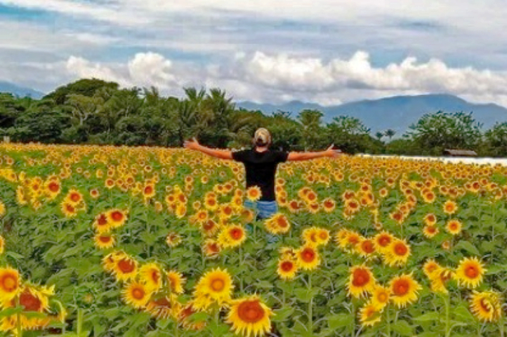
Entering to contemplate the 180 thousand sunflowers has no cost. The only recommendation of the owner Alfredo Villadiego is that the visit is made with all the biosecurity protocols and without making noise because they can scare the bees!
Sunflower Tourism in Valledupar, Cesar
Sunflower Fields in Valledupar, Cesar, Colombia CC Publimetro.co
The cultivation of sunflower in the department of Cesar arose thanks to the union of several farmers. As in Bolivar, AgroFrance International distributed the seed to the local agricultural farmers.
The crops are located on the road that leads to the village of El Jabo, five minutes from Valledupar, at Finca La Esmeralda, and there are other fields distributed in the village of Los Venados, and in the municipality of Urumita in La Guajira.
Sunflower as an Alternative Crop
Sunflower cultivation in Cesar has become a planting alternative due to the scarce markets for rice, corn, cotton, sorghum, and other products, and it is a plant that does not require abundant water. Farmers in the area hope to harvest the grain to take it to agribusiness as oil or flour.
Bee sanctuary, therapeutic and tourist attractiveness
The harmonious and constant buzzing of bees accompanies this yellow feast, making it a sanctuary for bees. Thousands of bees arrive in swarms from the mountains to give life to the crops and help the pollination of this plant.
Some countries such as Germany, Austria, Denmark, Spain, Belgium, France and Greece must implant bee hives, artificially, due to the scarcity of this insect in these countries.
One of the owners of the crops has witnessed how hundreds of people come to appreciate these flowers, and for the landscape impact of 200 thousand sunflower plants framed under the silhouette of the Sierra Nevada de Santa Marta, which for some resembles Swiss landscapes.
The fields have even been visited by several people with health problems to enjoy the beauty of the crop. In this way, they are contributing to the community.
Important Precautions When Visiting a Sunflower Field
You should wear appropriate footwear for the tour and the mud.
Avoid wearing strong perfumes before visiting, as they attract bees.
In addition, it is recommended not to run inside the field and it is forbidden to cut the sunflowers.
Remember, these places are especially for those who wish to enjoy nature.
If you want to know more about nature and agro-tourism destinations in Colombia do not hesitate in contact us or visit our Plan your trip page.
The current director of Sula. Doctor in Biological Sciences. Her main interests are to explore and understand the organism-environment interactions, taking advantage of emerging knowledge for the management and conservation of species and ecosystem services. She is currently working as a consultant in functional ecology, ecosystem services, and conservation projects in Colombia related to ecotourism and birdwatching.
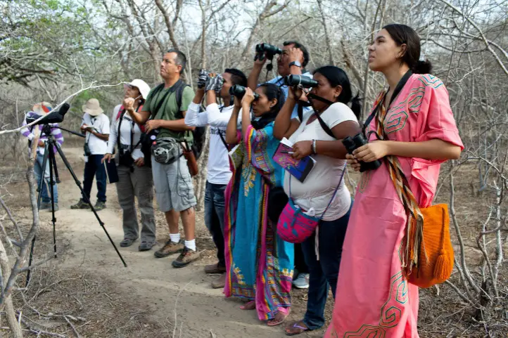
Birdwatching in Tolima is recognized as a new sustainable opportunity to develop local economies, while important ecosystems and bird species of the region are conserved. Find here the Tolima Birding Routes created for your visit, and why you should go there.
Conservation Efforts
In February 2021 Tolima department recognized 10 emblematic bird species, which are expected to contribute to promote birding tourism industry and bird conservation. The official administration announced the Draft Ordinance No 004 of 2021 by which:
“the emblematic birds of Tolima are declared as a symbol of ecological and cultural heritage, and their protection and conservation is promoted”
This resolution is part of the efforts made to know and protect Tolima’s birds and ecosystems. This set of special birds will be an object of conservation in the region.
Thus, public institutions, professionals and the local community will work together to develop activities to promote the knowledge, protection and conservation of the birds of the department of Tolima.
Among the programs, environmental education, citizen science and nature tourism have an essential role. Moreover, programs related to community based and birdwatching tourism are sustainable opportunities wich will contribute to the socio-economic growth of the region.
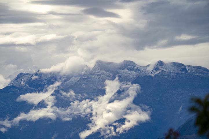
Tolima Ecosystems
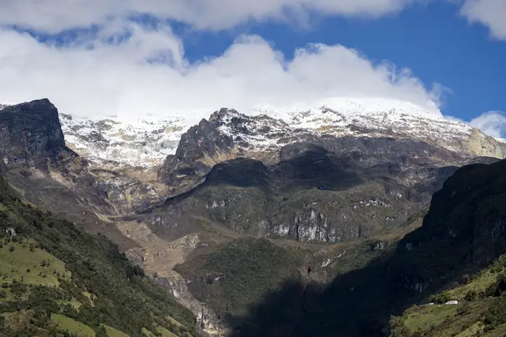
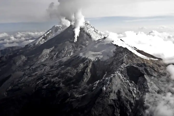
Nevado del Ruiz view from the Tolima’s side
Tolima stands out among the most biodiverse destinations in the country. Its wide range of natural environments ranges from the snow-capped mountains of Tolima, Santa Isabel, Ruiz and Huila, to the dry and humid forests of the upper and middle basin of the Magdalena River. This allows the presence of a richness of bird species close to 800 species.
In the territory of Tolima, 22 endemic and 49 near-endemic species have been recorded. It is the winter habitat of 67 species of migratory birds.
On the other hand, 28 species of birds are threatened with extinction, and there is an urgency to preserve them.
It is distributed in the lower areas of the upper basin of the Magdalena Valley, and has a diversity of habitats for birds such as forest fragments, scrublands, grasslands and wetlands.
Destinations: Venadillo, Armero Guayabal, Coello, Ibagué, Prado, Lérida, Alvarado, San Luis, Piedras, Honda, Melgar, and Mariquita.
Tropical Rainforest
These forests go up to 1,000 m in elevation and have species representative of the Magdalena Valley.
Destinations: Honda, Falan, Mariquita, and Fresno.
Montane Forests
They are the best represented ecosystem in Tolima and occupy 20% of the department’s surface. They are located on the Andean slopes of the central and eastern mountain ranges, between 1000 and 2000 m above sea level. These forests are the habitat of most of Tolima’s emblematic endemic bird species.
Destinations: Juntas, Cajamarca, Chaparral, Planadas, Líbano, San Antonio, Villarrica, Cunday, Casablanca, and Ibagué.
High Andean forests and Páramo
These are strategic high mountain ecosystems, located between 2500 – 4000 meters above sea level, bordering the beginning of the glaciers of the department’s snow-capped volcanoes.
Destinations: Anzoátegui, Murillo, Cajamarca, Ibagué (Toche), and Roncesvalles.
Emblematic Birds of Tolima
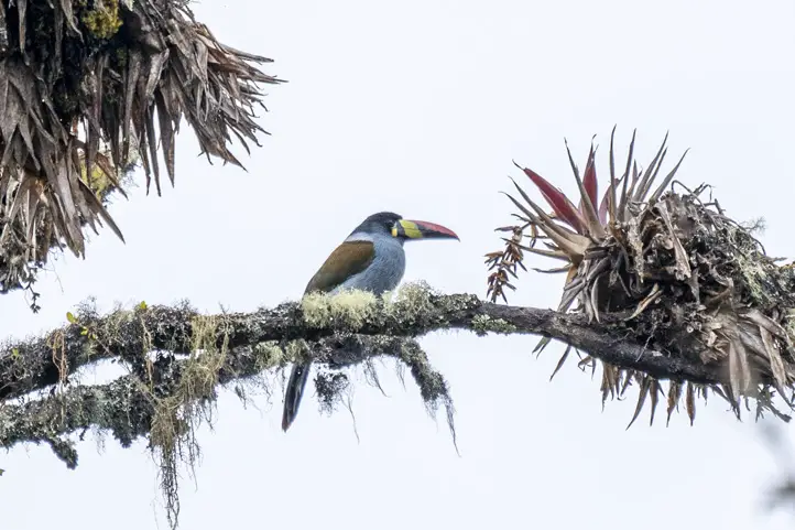
Tolima Blossomcrown
Anthocephala berlepschi
Tolima Blossomcrown (Anthocephala berlepschi) visiting a Mermelada plant (Streptosolen jamesonii) at Ukuku Lodge, Tolima
Why it is important
This is an endemic hummingbird of Colombia. It distributes along the Colombia’s central Andes, and the eastern Andes, in the southern part of the country.
Where to find it
Ukuku Rural Lodge. Ukuku is a small rural ecolodge located in the beautiful Combeima River Canyon, in the municipality of Ibagué – Colombia.
It is a place surrounded by fauna and flora of the high Andean ecosystem. In fact, its name comes from a Quechua word meaning Spectacled Bear, a unique species of bear in the Andes.
This ecolodge reflects the life philosophy of its creators, a nice couple of biologists and mountaineers. They created a rural alternative for rest, adventure, relaxation and coexistence with nature.
The Tolima Blossomcrown visists their gardens every day in the mornig and in the afternoon. Their favorite plant is the Mermelada, Streptosolen jamesonii.
Yellow-headed Brushfinch
Atlapetes flaviceps
Why it is important
This brushfinch is another endemic species of Colombia. It has a limited range of distrubution in the central and western Andes of Colombia.
Where to find it
In Tolima, you will find this bird when visiting the Combeima Canyon and the Ukuku Lodge, in the montane forests.
The Combeima Canyon is a buffer zone of Los Nevados National Park. It locates on the eastern side of the Central Andes between 1400 and 4200 meters above sea level.
The route to the Combeima Canyon is 18 km long from the Plaza de Bolivar, in the center of Ibagué, to the village of Juntas. The road runs along the banks of the Combeima River.
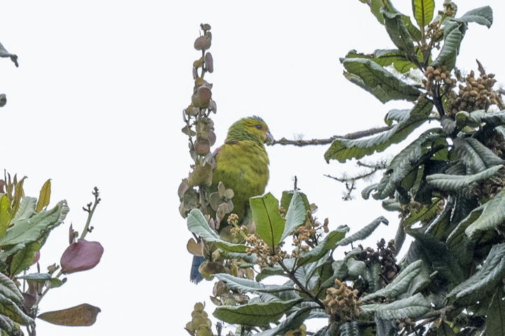
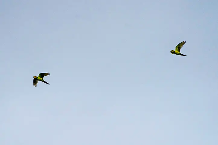
Rufous-fronted Parakeet
Bolborhynchus ferrugineifrons
Why it is important
This is a parakeet you will find only at very high elevations in Colombia’s central Andes. And, as if that were not enough, it is also a very scarce and difficult bird to watch.
Where to find it
In Tolima, the Rufous-fronted Parakeet can be observed in Los Nevados National Park, going up through the municipality of Murillo towards the Nevado del Ruiz snow-capped mountain.
Murillo is the highest municipality in the department of Tolima with 3,000 meters above sea level. Because of its proximity, it is very easy to appreciate the Nevado del Ruiz.
Velvet-fronted Euphonia
Euphonia concinna
Why it is important
This is a bird endemic to the Tropical Dry Forest in the Magdalena Valley in central Colombia. It is found from around 200 to 1,000 meters above sea level.
It is a difficult bird to observe, as it is uncommon within its range. In addition, it is commonly mistaken for Orange-bellied Euphonia.
Where to find it
It is possible to observe the Velvet-fronted Euphonia in the municipalities of Tolima placed around the Tropical Dry Forest of the Magdalena Valley such as Venadillo, Armero Guayabal, Coello, Ibagué, Prado, Lérida, Alvarado, San Luis, Piedras, Honda, Melgar, and Mariquita.
There are other interseting birds that can be observed in the tropical dry forests of Tolima, such as:
Apical Flycatcher (Myiarchus apicalis)
Colombian Chachalaca (Ortalis columbiana)
Burrowing Owl (Athene cunicularia tolimae)
Agami Heron (Agamia agami)
Whistling Heron (Syrigma sibilatrix)
Wood Stork (Mycteria americana)
Pheasant Cuckoo (Dromococcyx phasianellus)
Red-Billed Esmerald (Chlorostilbon gibsoni)
Shining-green Hummingbird (Lepidopyga goudoti)
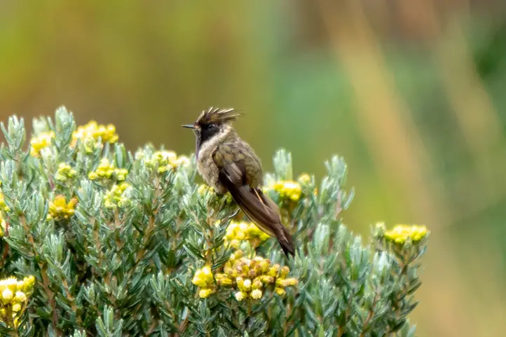
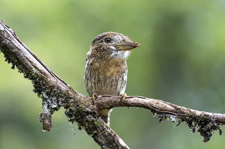
Brown-banded Antpitta
Grallaria milleri
Brown-banded Antpitta – Grallaria milleri
Why it is important
This is an antpitta restricted to cloud forest in Colombia’s central Andes. As many other antpittas, it spends most of the time on the forest floor, which makes it difficult to see.
This bird is easy to see in the feeders of the Rio Blanco Ecological Reserve near Manizales. Yet, Tolima is working hard to become a destination to watch the Brown-banded Antpitta.
You can find it in the montane forests of Tolima, between 1000 to 2000 meters above sea level. Places with these kind of forests are: Cajamarca, Chaparral, Planadas, Líbano, San Antonio, Villarrica, Cunday, Casablanca, and Ibagué.
Other species you can find in the montane forests of Tolima are:
This bird is also endemic to northwestern Colombia. Occurs in lowlands up to about 1,100 m. Typically seen in pairs or small groups in the forest understory, often near water.
Where to find it
It is found in the humid forests of Tolima. This life zone is represented in the municipalities of Mariquita, Honda, Fresno and Falan in the beginning of the middle Magdalena Valley. These forests protect a large percentage of the country’s biodiversity.
Other species you can find in the humid forests of Tolima are:
Parker’s ant bird (Cercomacra parkeri)
Beautiful woodpecker (Melanerpes pulcher)
Yelow-tufted Dacnis (Dacnis egregia)
Chestnut-backed Antbirds (Myrmeciza exsul)
White-mantled Barbet (Capito hypoleucus)
Sooty-headed Wren (Pheugopedius spadix)
Barred Puffbird (Nystalus radiatus)
Golden-headed Manakin (Ceratropipa erytrocephala)
White-bibbed Manakin (Corapipo leucorrhoa)
Indigo-winged Parrot
Hapalopsittaca fuertesi
Indigo-winged Parrot – Hapalopsittaca fuertesi
Why it is important
This is a rare and endangered parrot restricted to high elevations in the central Andes of Colombia.
In Tolima, this bird can be seen in the high andean forests, between 2500 to 4000 meters above sea level, in the areas of Los Nevados and Las Hermosas National Parks, and Nevado del Huila, in the municipalities of Anzoátegui, Murillo, Cajamarca, and Toche.
In Tolima, this bird can be seen in the high andean forests, between 2500 to 4000 meters above sea level, in the areas of Los Nevados and Las Hermosas National Parks, and Nevado del Huila, in the municipalities of Anzoátegui, Murillo, Cajamarca, and Toche.
Wax Palm at Toche, Tolima
Roncesvalles was also a good place to watch this bird, but saddly this year one of the rangers Colombian conservationist of the area was killed. So, tourism is closed since then in this area. Know more about this story in the Audubon’s post Remembering Gonzalo Cardona, Protector of the Yellow-eared Parrot.
Black-backed Bush Tanager (Urothraupis stolzmanni)
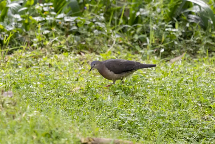
Tolima Dove
Leptotila conoveri
Tolima Dove – Leptotila conoveri
Why it is important
This is another unique species of the Andean cloud forest in the central Andes of Colombia. At the national and international level, it is listed as an Endangered species.
Where to find it
This bird is easy to see in the gardens of Ukuku Lodge, near to the Combeyma Canyon.
Now that you know about the wonderful birds of Tolima, you understand that this is an unmissable destination on your birding trip to Colombia, especially if you want to record some of the endemic species of our country.
Current director of Sula. Doctor in Biological Sciences. Her main interests are to explore and understand the organism – environment interactions, taking advantage of emerging knowledge for the management and conservation of species and ecosystem services. She is currently working as a consultant in functional ecology, ecosystem services and conservation projects in Colombia related to ecotourism and birdwatching.
Colombia is a megadiverse country. It is also a country with a difficult history. War has been around for more than 60 years. With the signing of the peace agreement in 2016, Colombia opened up as never before, presenting a rich, unexplored and under-exploited territory. It also was the starting of the post-conflict struggle.
Paradoxically, the conservation of natural habitats in Colombia was facilitated by the war conflict, preventing territories from being invaded by development and deforestation.
Colombia’s Post-conflict Scenarium
Tourism has been one of the sectors that have benefited the most from the peace agreement, especially nature tourism.
One of the economic benefits of the peace agreement in Colombia has been that local communities have an alternative business opportunity in bird watchingtourism.
The most remarkable result was the bird-watching expansion to areas, that were formerly unsafe, such as Caquetá and Putumayo.
Western Striolated-Puffbird, Nystalus obamai. Fin del Mundo, Putumayo, Colombia.
However, not everything has been rosy. This time of transition has cost us, especially due to the lack of proper administration and governance in the territories that were liberated from the conflict.
The Environmental Cost of the Post-conflict
Deforestation
Many studies on post-conflict dynamics have concluded that the social, political, and administrative imbalance that remains in the new peace territories leads to environmental degradation, especially through increased deforestation.
Unfortunately, it has been recognized that the main threat to Colombian birds is the loss of habitat caused by deforestation. Deforestation occurs when people begin to use the resources to which they did not have access before.
Carrying Capacity Excedeed
Another aspect is the deterioration of the new sites due to uncontrolled visitation by tourists and visitors, which exceeds the carrying capacity limits of many of these sites.
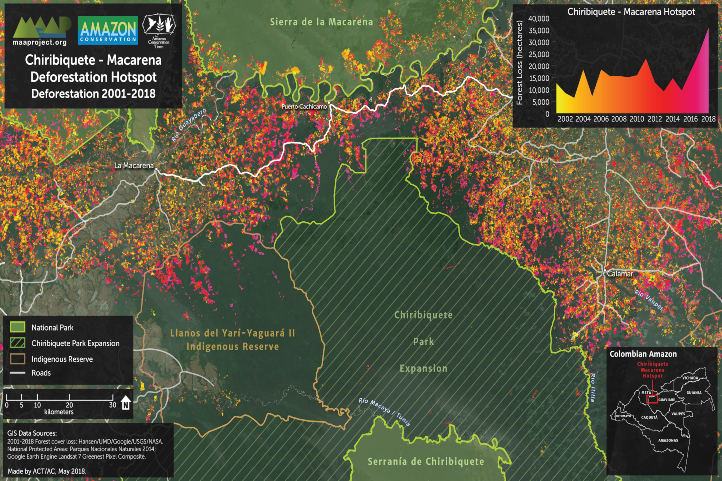
An example of this is the Chiribiquete National Natural Park, which had to be closed to visitors due to vandalism and overcrowding. In addition, the park has also been threatened by deforestation.
Other Conflicts
Likewise, demobilization has not been complete, and there are still some illegal groups that continue with their own agenda.
Finally, it is unfortunate to have to mention that the murder of environmental leaders has also seriously affected the country.
The Boom of Scientific Expeditions
In Colombia, the peace process also allowed scientific explorations to expand in the territory, as it was possible to visit places previously closed due to public safety issues.
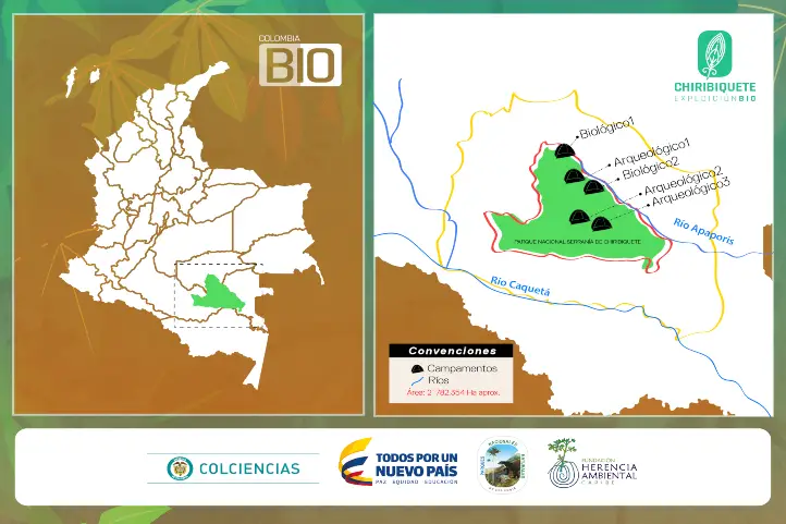
After the signing of the peace treaty, the Colombia Bio project, promoted by Colciencias, was launched in the country.
Colombia BIO aimed to carry out 20 expeditions in the period between 2016 and 2018 in order to generate knowledge about biodiversity. The expditions were possible thanks to the end of the conflict.
The expeditions were conducted in continental and marine areas that were:
Unexplored areas,
In post-conflict territories,
Under threat, or
Associated with transformed landscapes.
Many of the explored areas shared several of those characteristics. The Colombia Bio expeditions discovered countless new species of fauna and flora in the country.
Thanks to this, and to the great impulse that the Colombian government gave to birdwatching tourism, Colombian ornithologists, as well as bird lovers, now have more and better information about the birds of the most bird-rich country in the world.
2021: 5 Years After the Signing of the Peace Agreement
In 2021 it will be five years since the signing of the peace agreement. Since then, the country has been preparing to become a world-class bird-watching destination.
Some improved main roads, such as the La Linea tunnel.
More offers related to reliable transportation, and
A better understanding of attention to the peculiar needs of birders (early breakfast, comfort, silence, etc.).
Additionally, today we have a big advance in terms of policy for tourism and nature tourism training.
First Sustainability Policy for Tourism in Colombia
The Ministry of Commerce, Industry and Tourism launched the first sustainability policy for tourism in Colombia in December 2020. It is called the Sustainable tourism policy “United for Nature”.
This sustainability policy aims to position sustainability as a fundamental pillar for the development of tourism in Colombia through a strategic plan for 2030 called the Roadmap for Sustainable Tourism.
This plan is composed of six strategies, 14 programs, 32 projects and 140 policy actions.
Sustainable Development Goals
The objectives of the plan focus on the following guidelines:
Reduction of greenhouse gas emissions.
Efficient energy management and investment in renewable and non-conventional energy sources.
Responsible management of solid waste.
Saving and efficient use of water.
Adequate wastewater treatment.
Protection of the country’s biodiversity and ecosystems.
First Guide for Nature Tourism in Colombia
They also launched the first guide for nature tourism in Colombia together with ProColombia, and the support of USAID’s Natural Wealth Program; the Humboldt Institute; and the Wildlife Conservation Society (WCS).
At the same time, Since 2015, Audubon, in collaboration with Asociación Calidris, has been working on bird-based ecotourism initiatives in Colombia to support local development and conservation.
Picture from Audubon: “Wayuu indigenous students and teacher Alvaro Jaramillo are bird watching in La Guajira, Colombia this past June. The program teaches locals to become tour guides for travelers interested in spotting birds. Photo: Carlos Villalon”
Audubon has been training many people as specialized bird tour informers in all regions of Colombia, and developing the following birding routes:
However, bilingual and bird-focused guides, as well as specialized birding infrastructure, such as canopy towers or canopy trails, platforms, hides, etc., are still underdeveloped.
Therefore, if you come to Colombia to watch birds, especially on your own, you will have the best guides in local people, as they have a first-hand experience with the local landscape and wildlife, but with low or basic training in bird identification and foreign language skills (i.e. English).
How We are Helping
In Sula we always work with the local community. Whether it is with the accompaniment of a local guide, with local transportation services, with lodging in hotels and lodges developed by local people, among others.
Visiting Usiacurí and Luriza Reserve
We have first-hand knowledge of all our allies, and also help people in their regions to develop and/or improve their products and services.
Organize your trip with us, so that you have the best services, and at the same time help the economic development of the regions you visit.
Current director of Sula. Doctor in Biological Sciences. Her main interests are to explore and understand the organism – environment interactions, taking advantage of emerging knowledge for the management and conservation of species and ecosystem services. She is currently working as a consultant in functional ecology, ecosystem services and conservation projects in Colombia related to ecotourism and birdwatching.
Guaviare is one of the least populated departments of Colombia, and one of the most pristine nature destinations in the country.
Additionally, this department is located in the Colombian Amazon region, although part of its territory is also in the Orinoquia. Its capital is San José del Guaviare.
Brief history of Guaviare
In the past, the colonization of Guaviare was mainly due to the enormous natural riches of its soil and the exploitation derived from these.
People came there to cultivate balata and rubber. Moreover, trade of wild animal skins, native plants and ornamental fish was also common.
Finally, the illicit cultivation of coca attracted many people, bringing also war and chaos to the region.
Today, tourism is opening as a new possibility for the economic development of the region, and it works as a good strategy for the protection and conservation of natural and archaeological areas.
Weather and Landscape
The dry season happens from December to February, and the rainy season during the rest of the year (especially April-July and October-November). Annual rainfall ranges from 2,000 to 3,500 mm. The temperature during the day reaches 25° to 30 °C, dropping at night to 12 °C between July and August.
Its soils are bathed by numerous rivers and a network of streams, divided mainly into two basins: Orinoco River Basin and Amazon River Basin.
Tourism in Guaviare
Tourism is making its way in this destination dedicated to adventure and sustainability. It is an opportunity for sustainable development in he region. The natural environments for swimming, the sunsets, and its ecosystems make it a unique destination.
Archaeological places, and the fauna and flora that make up an abundant biodiversity, are the greatest attraction of Guaviare.
The Most Featured Destinations in Guaviare
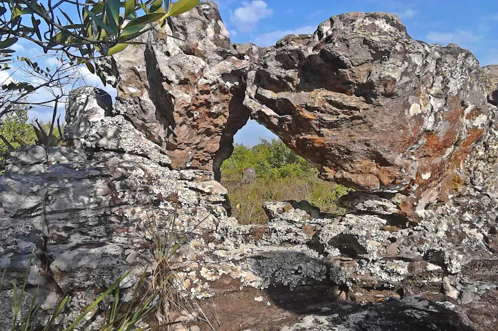
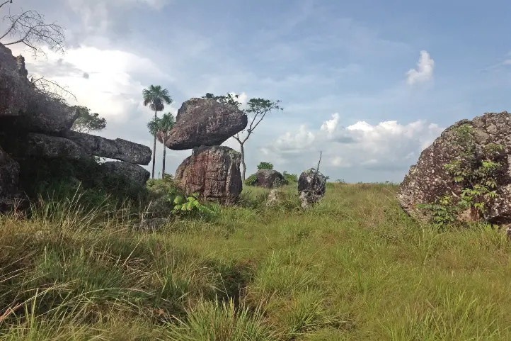
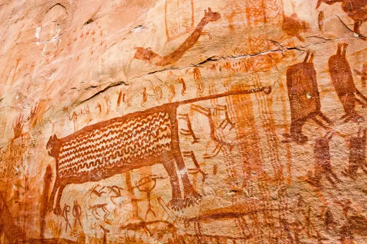
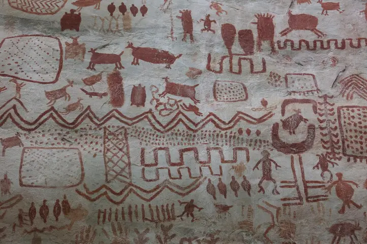
Serrania de La Lindosa and Cerro Azul
Serranía de la Lindosa @Parques Naturales
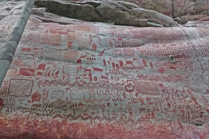
This place is one of the eight archaeological zones declared as a protected area by the Ministry of Culture of Colombia.
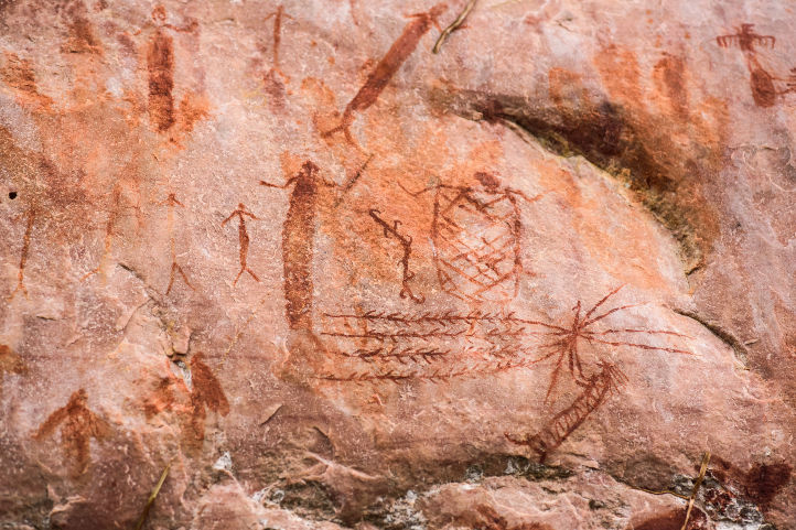
Here you will find the famous cave paintings, among others those of the Guayabero River and the Caño Dorado, with vivid colors. In the Cerro Azul in the Serranía La Lindosa, you can observe paintings that are twelve thousand years old.
The summit of Cerro Azul can be reached by a medium level hike of approximately 40 minutes. In Cerro Azul, there are a series of cave paintings painted with reddish pigment by indigenous people who inhabited the La Lindosa mountain range 7,250 years ago.
It is a two-hundred-meter-high peak to explore and walk. During the walk you can find giant trees and native species of flora and fauna. From the top you can see numerous streams of crystalline water and the jungle.
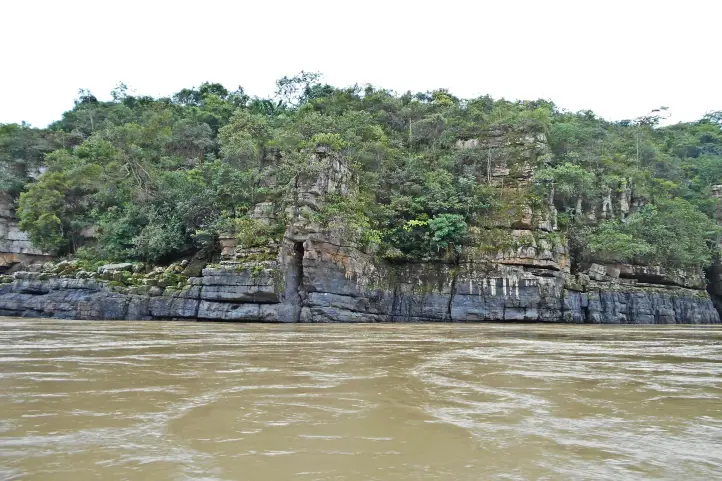
Raudal of the Guayabero
Raudal del Guayabero @ Juan Pablo Rozo – Wikiloc
This spectacular spot is one hour by river, and one hour and thirty minutes by land, from San José del Guaviare.
The Guayabero River, before its encounter with the Ariari, is framed in a canyon formed by walls of rocks of Pre-Cambrian origin.
From there, a current is unleashed that reaches half a kilometer in length. Although it is navigable throughout the year, the summer season is the best time to cross it.
Throughout the tour you can see the gray freshwater dolphin or Tonina (Sotalia fluviatilis), as it is called by the inhabitants of the region.
Natural Bridges
Rocky Bridges Pic. by Parques Nacionales
These natural bridges are high and have been shaped and polished by water over time. They stand on a ravine to which it is possible to descend with certified guides.
The Stone City of San Jose, is an enigmatic place that consists of ancestral rocks distributed with an impressive and mysterious symmetry.
In the company of guides, you can tour this site that has labyrinths, caves, and monoliths with very old petroglyphs. A special place for hiking and caving.
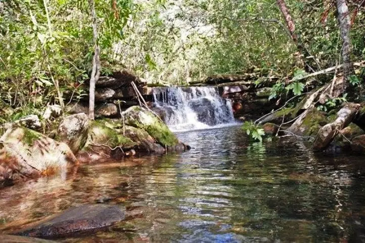
Natural Baths of Agua Bonita, Villa Luz and Tranquilandia.
Tranquilandia Bath
They are located only five miles from the city, in Caño Sabana. The ancient rock formations form pools of crystalline waters of different colors. The rich plant and mineral environment is the one that colors these waters, so it is very similar to the rainbow river in La Macarena. You can go there and enjoy a good swim and landscape.
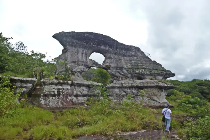
Puerta de Orión
Puerta de Orión Pic. by Parques Nacionales
Orion’s Gate is a rock formation emblematic of the city, found 9 kilometers from San José del Guaviare. It is twelve meters high and 20 meters wide. It has two natural holes, one on top of the other.
To get to Puerta de Orión you must pass through cavities and cornices that make it an enigmatic scenery.
The particularity of this natural wonder is that in the summer solstice you can observe Orion’s Belt through the upper window, creating a unique spectacle.
Laguna Negra is located 11 kilometers from San José del Guaviare. The black color that the water projects is because at the bottom there are decomposed leaves from the surrounding forests.
Its name is due to the dark tone of its waters seen from the air. Once on land, you can see a scenario of crystalline water, according to experts, because of the thick vegetation that surrounds it.
This natural reserve, 11 km from San José del Guaviare, constitutes the ideal scenario for the practice of artisan fishing and snorkel. You can find “cachazas” and “payaras”.
Kayaking and sailing, among other practices, are part of the new offer.
Because it is a complete planetary treasure, in 2018 it has been declared a mixed heritage of humanity.
It is located in the departments of Caquetá and Guaviare, and preserves the largest sample of rock art in the world.
In Chiribiquete there are approximately 70,000 paintings and 50 panels of an average height of 7 meters.
These have served to distinguish a cultural tradition of roots, apparently very old, of the Paleo-Indian. Therefore, they have been associated with groups of hunter-gatherers of the Tropical Rainforest and semi-dry enclaves of the Guianas and the Amazon.
Other Attractions
Guayabero Pic. by Juan Pablo Rozo – Wikiloc
Rural and community tourism: Finca Chontaduro, Finca Diamante, replacement of coca for fruit.
The “Flor del Guaviare” (Paepalanthus formosus Moldenke) is one of the emblems of the department.
The trip Bogotá – Guaviare by plane takes about 1.20 hour. The tourist sites are easily accessible by 4X4 vehicles. The capital, San José del Guaviare, has become a center of operation with a wide range of lodging facilities: three stars hotels, hostels, and camping.
Where to stay in San José del Guaviare
We recomend you the following hotels in San José del Guaviare:
Hotel Quinto Nivel
Hotel Aeropuerto
If you want to know more about the most incredible natural destinations in Colombia, plan your trip with us!
Current director of Sula. Doctor in Biological Sciences. Her main interests are to explore and understand the organism – environment interactions, taking advantage of emerging knowledge for the management and conservation of species and ecosystem services. She is currently working as a consultant in functional ecology, ecosystem services and conservation projects in Colombia related to ecotourism and birdwatching.
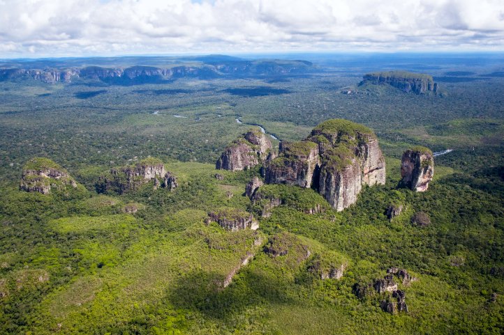
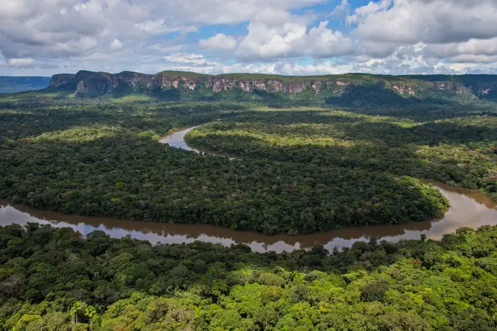
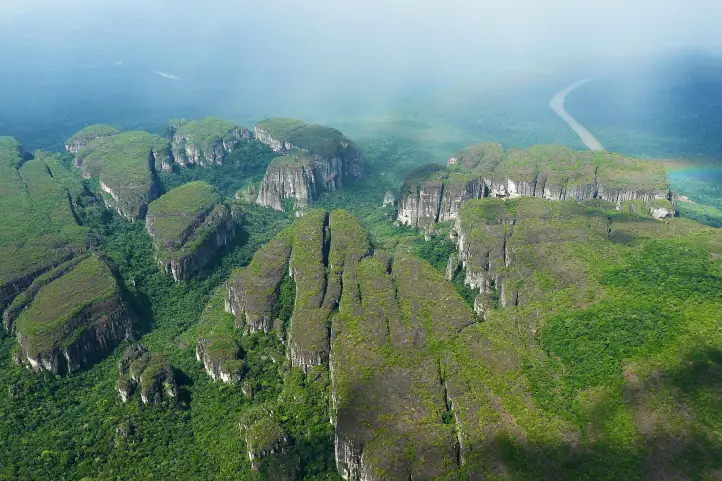
Serranía de Chiribiquete mountain range, and its surroundings, present a landscape in which strange forms rarely seen or even imagined stand out.
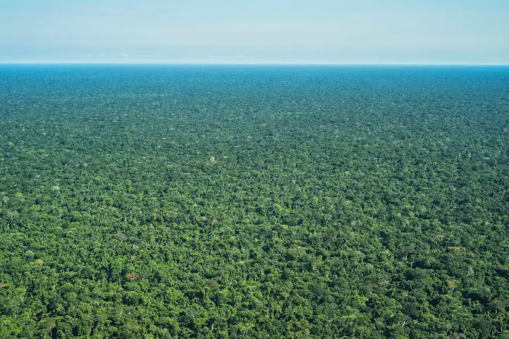
Together with the enormous extensions of virgin forest, it makes an illusory, magical and very old “lost world”, in the heart of the Colombian Amazon.
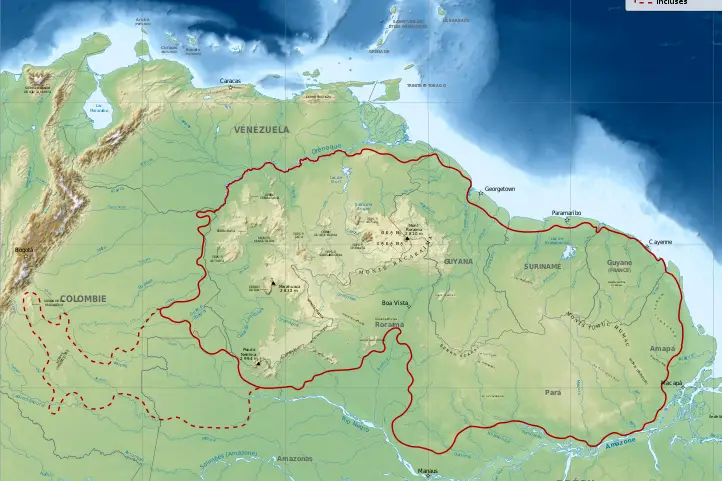
The Guiana Shield
The Guiana Shield is a geographic region located in the northeast of South America. It is a very old geological formation, being one of the oldest areas on Earth, from the Pre-Cambrian era.
Almost from the very moment of the formation of the planet Earth, some very high plateaus with vertical slopes, called tepuis, have originated in this place.
Tepuy is a term from the indigenous Pemón language, which means “mountain”.
In the Guiana shield, you will find the famous Angel Falls, or Kerepakupai Meru, the highest waterfall in the world with 979 m. Also, the highest and most impressive tepui of all, Mount Roraima. Both in Venezuela.
The Guiana Shield of Colombia
The western part of the Guiana shield is located in the eastern zone of Colombia, covering the departments of Guainía, Vichada, Vaupés, Caquetá, and Meta.
The Guiana Shield penetrates Colombia, across the border with Venezuela and Brazil, and possessess those characteristic rocky outcrops known as Tepuis.
Being so far away from the Andean system, deep in the Colombian Amazon, these outcrops of the Guiana Shield are little known, with some exceptions.
Among the most famous tepuis are Cerros de Mavecure, in the department of Guainía, Sierra de La Macarena, place of the rainbow river, in Meta, Serranía de La Lindosa in Guaviare and the Iguaje tables, in Caquetá.
These mountains are a reduced scale version of the great mountains of the Guianas that culminate in the hills of La Neblina and Roraima in Venezuela.
Serrania del Chiribiquete
The Serrania del Chiribiquete is one of the oldest geological formations on the planet and is part of the Guiana Shield.
The mountain range of Chiribiquete was the territory of Paleoindian groups that left graphic testimony of the temporary occupation of some of its tepuis in many cave paintings.
According to the experts, Chiribiquete was used as a rocky shelter that served as a temporary refuge and also as a place of worship for centuries.
The Rupestrian Art of Chiribiquete
Chiribiquete is one of the most emblematic places of American rupestrian art.
In this place, there is a collection of murals with more than 75,000 cave paintings, where the jaguar is the protagonist. But this number only represents between 5% to 8% of all of the paintings there.
The pictographs are supposed to be ancient writings that have maintained the existence of the ‘secret of the world’. For this reason, it has been called the Sistine Chapel of the Amazon. From there, the ancestral stories of some of the indigenous peoples of the region emerged.
Some studies point out that the human presence in the area of Chiribiquete possibly dates back to 15500 years BC.
According to more recent archaeological and chronological evidence, it has been specified that the age of the rupestrian art of Chiribiquete is around 22000 years, which makes it the oldest on the continent.
Serrania de Chiribiquete National Natural Park
Chiribiquete is also a place where the biological richness is almost intact. There are few places in the world with these conditions, these characteristics of insularity, endemism, fragility and biodiversity.
The Serrania de Chiribiquete National Natural Park was created in 1989. This park is a mega reserve that contributes to maintaining the physical and biotic components of one of the areas with the highest biological diversity on the planet.
Scientists refers to Chiribiquete as a place with a high degree of endemism, and there is the discovery of new species with every expedition that has been made.
The declaration of Chiribiquete as a World Heritage Site (by UNESCO) occurred in July 2018; at which time the Government of Colombia also expanded the park’s territory.
Thus, the park constitutes a mixed heritage of humanity, since it represents a great contribution to the preservation of biodiversity and natural ecosystems for the planet; as well as the multiplicity of cultural expressions of the communities that have settled through time in the territory.
Tourism in Chiribiquete
The demobilization of the FARC (Revolutionary Armed Forces of Colombia) in 2016 made one think about tourism.
Unfortunately, the human presence caused vandalism, and the park has also been threatened by mining and illegal logging.
Opening this place as a tourist destination would end up greatly altering the conditions of the place, because it requires infrastructure, services, and permanent transit of people.
Thus, in order to protect Chiribiquete’s archeological and natural treasure, it is closed to the public. And you can only fly over it.
Overflights in the Serranía de Chiribiquete NNP
The aircraft will take off and land at the Jorge Enrique González Airport in the city of San José del Guaviare.
The overflights will take place in a single corridor defined and approved by National Parks, and there is a maximum time of three hours per overflight.
The season, duration, and route of the overflights were designed to guarantee the protection of the ecosystems, and of the indigenous peoples in voluntary isolation who inhabit the area.
Where to stay in Chiribiquete NNP
Staying in Chiribiquete NNP is not allowed. However, since flights take off from San José del Guaviare, you can think about staying there. This way, you will have the opportunity to appreciate the natural and cultural richness of the Serranía la Lindosa.
Serranía La Lindosa
The Serrania La Lindosa is located 1.5 hours from San José del Guaviare. It is one of the places with more cave paintings in the world, and has been declared a Protected Archaeological Area of Colombia by the Colombian Institute of Anthropology and History, ICANH.
This place is open for ecotourism, being the ideal space for you, before or after your flight, to get close to what you can find in the Serrania de Chiribiquete National Natural Park.
Best time to visit Chiribiquete NNP
Only two overflights are allowed per week and during January, Easter, June, July, October and December.
Chiribiquete NNP Entrance fees
Overflights might vary according to the season, availability, tour operator and the number of travelers. However, an overflight may cost around 1450 USD.
If you are planning a trip to Colombia, we are happy to help you have an unforgettable nature experience! Contact us.
Sara Colmenares Current director of Sula. Doctor in Biological Sciences. Her main interests are to explore and understand the organism – environment interactions, taking advantage of emerging knowledge for the management and conservation of species and ecosystem services. She is currently working as a consultant in functional ecology, ecosystem services and conservation projects in Colombia related to ecotourism and birdwatching.
Two events have consolidated Guainía in the minds of travelers, the first, the signing of the peace agreement and the second, the launch of the Ciro Guerra’s film The Embrace of the Serpent (El Abrazo de la Serpiente), winner of multiple awards around the world.
Guainía
Guainía in the Yuri language means “Land of many waters”. Its capital is Inírida, and it is located in the east of the country. The temperature of the region oscillates between 25 and 30 degrees centigrade.
Most of its territory is made up of flat extensions, although there are some elevations, mainly the so-called tepuis, which are remnants of the Guiana shield, the oldest mountainous formation on the planet.
The most famous hills are the Mavecure, but there are others hills and mountains like the so-called Aracuari, Canapiari, Guasacavi, Mavicure, Pajarito, Rana, Salvaje, Sáquiras, Sardinas, and the mountains of Caranacoa and Naquén, with heights slightly above 500 meters above sea level.
In the past this was a region afflicted by armed conflict and violence, but this situation is now in the past and the community has found in tourism an opportunity for life.
Communication Routes and Transportation in Guainía
In the department of Guainía, the main communication route is the rivers, which are the road axes of access. Roads are scarce and only passable in the dry months.
It is also important the air transport. There are two airports located in Inírida and in the town of Barranco Minas.
Tourism in Guainía
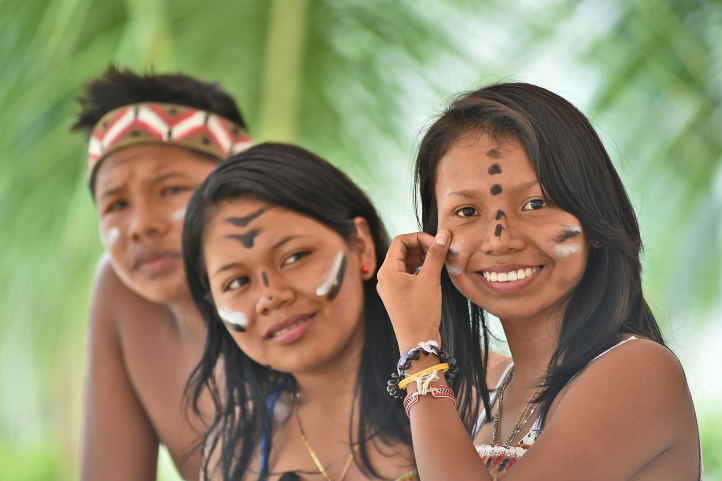
In Guainía one of the main attractions is its people, whose population is mostly composed of indigenous people (65%), who come from almost 30 different communities and belong to ethnic groups such as the puinave, curripaco, tukano, wanano, desano, piratapuyo, piapoco and yeral.
Guainía’s people
Other attractions are the Cerros de Mavecure, the Las Brujas lagoon, the Sapuara stream and the fluvial star. You can also find the Puinawai National Natural Reserve; the Pavón, Payara and Matevení Lakes, which together with the Inírida River, are destinations where you can practice water sports and sport fishing.
How to get to Guainía
You have to arrive by plane from Bogota to Puerto Inirida. The distance in straight line from Bogota is 720 Km, and it translates into 1 hour 10 min of flight.
It is recommended that you stay at least 4 days in the region to enjoy this majestic and sacred place.
In Inirida you can find several hotel offers, and all trips are made to and from the city by boat on the Inirida River and its tributary streams.
Below you will find the best destinations in Guainía.
Guainía Destinations
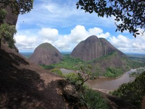
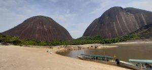
The Mavecure or Mavicure Hills
The Mavecure Hills are part of what we know today as deep Colombia. Embedded in the Amazon, they have become one of the most emblematic tourist destinations in Colombia.
In a study published about Ciro Guerra’s El Abrazo de la Serpiente, the Hills of Mavecure and surrounds are described as a landscape of enormousness, limitlessness, extraordinariness, and grandeur.
Mavecure Hills – Picture courtesy by Andrés Rodríguez, local indigenous guide.
The hills of Mavicure are three hours away from Puerto Inírida, the capital of Guainía. There are three tepuis called Mavicure, Mono and Pajarito that serve as an impressive viewpoint to the Guainía’s jungles.
From the top of the hills you can appreciate large extensions of jungle inhabited by indigenous communities such as the Puinaves and Curripacos.
According to Puinave Tomás Corda Medina, a native of the Barranco Tigre community, in an interview for a national newspaper:
“in the curripaco language, Mavecure comes from the words ‘mavi’, which is a palm used to make different utensils, and from ‘cure’, a poison that the ancestors took from a tree and put on the tips of their arrows for hunting with blowpipes.”
It is said that the hills were considered a magical space where humans could communicate with their gods.
The hills of Mavecure are 55 kilometers west of this city. To reach them you must take a speedboat that takes about 2 hours to travel the 55 kilometers through the Inírida River.
Climbing the Mavecure Hills
After arrival, you will have to spend the night in the El Remanso or in the El Venado indigenous communities placed at the foot of the hills.
You will need a guide to accompany you to the highest part of the hills, along the only trail suitable for walking and which does not require climbing equipment.
To reach the viewpoint, at 250 meters high, the only conditions are imposed by the weather and your physical condition. You must watch every step, and always go with a certified guide.
It is recommended to go up at a sunny moment. This is because, when it rains, the stone ground becomes slippery, and the slope makes the water run forming strong currents on the way down, which makes it very dangerous.
Once at the top you can see Pajarito and Mono; on their skirts you can see the dark green of a jungle that hides anteaters, water dogs, armadillos, limpets, chigüiros, tapirs, deer and tigers. In the distance, there are the caños that the river Inírida bathes, and other fluvial courses.
Mavecure Hills – Picture courtesy by Andrés Rodríguez, local indigenous guide.
The activities that you can do in the Mavicure Hills are bird watching, hiking, photography, and nocturnal fish watching on the banks of the Inírida River where you can see rays, guaracus, palometas, agujones and cuchas.
The Laguna de Brujas or Chalchuapa (in the language of the natives) is defined by the locals as an oasis of peace. It is a quiet place where you can escape to feel the sounds of birds and nature in all its splendor.
Situated 10 minutes by boat from Puerto Inírida, you will feel overwhelmed by the beauty of the surrounding forest. Laguna de las Brujas is announced as the preferred habitat of the pink dolphins.
A variety of stories are told among the natives, such as the legend of the “Pink Dolphin” which tells that spiritual leaders arrived there to talk to the pink dolphins about the future of the Amazon and its communities.
Others say that it was named after a legend about some witches who stole the water from another place known as “Hoyos de la caldera” (boiler holes), but during the trip they dropped the water in the air, forming the Brujas Lagoon.
The truth is that, regardless of their origins, tourists and locals can take tours through this splendid landscape in canoes, accompanied by an indigenous guide.
Caño Bocón
It is the paradise of fishing. Bocón is one of the main tributaries to the Inírida River. It is bordered by jungle.
This river is located in the territory of the Puinave ethnic community, thanks to which the river, and its lagoons, with its Peacock Bass and the large Payaras that live in it, are cared for and watched over.
Thanks to an agreement with the Puinave, fishing is allowed for a maximum group of 10 people, you will not see anyone else in fishing action during your week.
The fishing is fast and abundant: Peacocks, Payaras, Catfish, Palometas, Bocones, Morocotos, etc.
Viejita Lagoon
Another paradise for fishing in Colombia. Downstream from Puerto Inírida, where the river delivers its waters to the Guaviare.
After two hours of navigation towards the east, you can leave the river and walk around 15 minutes through the jungle until you reach the Viejita lagoon.
On a floating raft you go around the lagoon completely. From the raft you will witness epic sunsets and landscapes.
The Fluvial Star of Inírida (Estrella fluvial del Sur)
This is a must see in Colombia. This is a place where the rivers Guaviare, Atabapo and Inírida converge and swell the Orinoco River, one of the longest rivers in south American, and one of the top five largest rivers in the world.
Estrella fluvial del Sur, with its many rivers and lagoons, has been declared as a Ramsar Territory in 2014. This gave it recognition as a wetland of international importance, whose ecological and social value transcends the borders of a single country and benefits humanity.
The declaration of the Inírida River Star demand research efforts and substantial investments to safeguard the ecological integrity of the area. Ecotourism appears as a sustainable practice and activity compatible with the rational use promoted by the Ramsar Convention.
The River Star is home to 34% of Colombia’s wealth in freshwater fish species.
Colombia has the second largest number of freshwater fish species in the world.
The River Star is home to 70% of the known avifauna in Eastern Orinoco, 476 species of birds, two of which are exclusive to the place.
In the Inírida River Star there are 903 species of plants, 200 of mammals and 40 of amphibians.
The otter, the jaguar and the pink dolphin, present in the Fluvial Star, are in critical danger.
In the area there are two indigenous peoples, Puinave and Curripaco, five resguardos and 15 communities that inhabit them, who support and legitimize the decision of the declaration as a Ramsar territory.
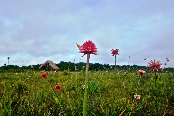
The Flower of the Inírida
It is an endemic plant of Guainía that grows in humid savannas and whose petals are red tips. Technically, the flower of the Inirida is two species of monocotyledonous herbs belonging to the family Rapateaceae. Both species are endemic to white-sanded savannas, with extremely poor, precarious soil conditions that are hostile to any plant.
Flowers of Inírida, winter Guacamaya superba, and summer Schoenocephalium teretifolium.
There are winter and summer ones and one is bigger than the other. The Winter Flower of Inírida (Guacamaya superba), the bigger one, blooms mainly during the rainy season in the region (June – October). On the other hand the Flower Summer of Inírida (Schoenocephalium teretifolium) blooms mainly during the season of drought (December – March).
Guainianos love and protect it and travelers admire it. It can be seen in all its magnificence in the savannahs on the way to Caño Bitina. During the flowering season, the savannah is dyed red because of the abundance of flowers.
Alto de Caño Mina
The Raudal Alto de Caño Mina, one of the tributaries of the Inírida River, is one of the most overwhelming in the Colombian Amazon.
This is one of the most emblematic destinations of this Secret Colombia. It has has a 15-meter waterfall of black, red and yellow waters. Its color is produced due to a great load of tannins it has.
It is necessary to go up the Inírida River for two days. Then you leave the Inírida River and enter through the Caño Mina.
Practice water ports such as skiing, diving and sport fishing.
Camping or hammock nights.
Hiking and trekking
Hiking through the forest to the indigenous community of Venado.
Recommendations
This is a trip to the jungle, so you have to be prepared for BASIC conditions of accommodation, food, transport etc. You will not find luxury things especially at night, because you will have to sleep in the community.
Additionally, take into account that the itinerary can vary according to the changes that the flights can have, the circumstances of the climate or unforeseen last minute.
Things you will need:
Wear comfortable, light-colored and lightweight clothing, hopefully waterproof.
Bring hats or caps for protection from the sun and wear a long-sleeved shirt.
Wear hiking shoes, preferably waterproof, and extra tennis shoes.
Photo or video camera to not lose any detail of these beautiful landscapes.
Abundant hydration for the walks, sunscreen and repellent.
A raincoat to cover yourself in case it rains.
Small backpack for the daily walks.
Flashlight.
Sleepwear. It is recommended to take a light sleeping, at night it can be cold.
Personal hygiene equipment in small quantities.
Tape, micropore and anti-irritation creams.
Camping equipment (tent, mattress) or hammock with ropes and tarp, depending on your preference for the first night.
Swimwear.
If you want to know more about the most incredible natural destinations in Colombia, plan your trip with us!
Current director of Sula. Doctor in Biological Sciences. Her main interests are to explore and understand the organism – environment interactions, taking advantage of emerging knowledge for the management and conservation of species and ecosystem services. She is currently working as a consultant in functional ecology, ecosystem services and conservation projects in Colombia related to ecotourism and birdwatching.
Come to Colombia to meet the outstanding Wax Palm! As we mentioned in a past entry, the Wax Palm, Ceroxylon quindiuense (Karsten) Wendl, is an endangered endemic species of Colombia. It is also the national tree and the star of one of the most beautiful and emblematic landscapes of the Colombian Andes.
Tourism is one of the most promising conservation strategies for this species. On the other hand, rural communities prefer it over agriculture, livestock, and mining.
Today there are all-terrain trucks that travel through areas such as Toche. There are even bicycle tours that take you to remote farms so you can enjoy the spectacular landscapes of the cloud forest with wax palms while descending to Toche or Salento.
Where to see Wax Palm Forests in Colombia
Salento and Valle de Cocora
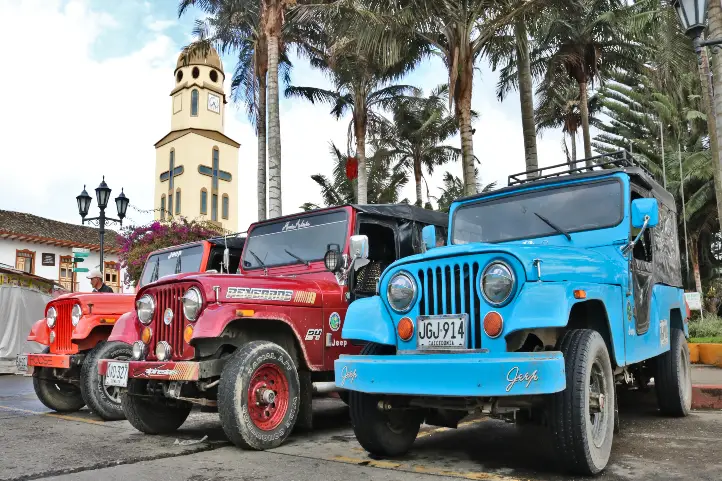
The municipality of Salento is the cradle of the national tree, the Wax Palm, and has a great variety of tourist attractions. Salento is the oldest municipality of Quindío and the oldest among the three main departments that make part of the Coffee Triangle (Caldas, Risaralda, and Quindío). It is a beautiful town, interesting for its typical crafts and its streets full of color and history.
Bolívar Square – Salento, Quindío
Walking around the town will help you get to know the architecture typical of the Antioquian colonization, in which mud and adobe houses predominate, with colorful gates made of wood, and windows and balconies full of flowers.
Colorful Streets of Salento
Colonial Balconies full of Flowers in Salento
Colonial Architecture of Salento
The best days to visit Salento are during the week, since there are fewer visitors. You will find a varied offer of accommodation among luxury hotels, hostels, camping areas, and glamping.
What to do in Salento
Among its most important attractions are:
The Cocora Valley
The National Natural Park Los Nevados
The Traditional Architecture of the Colonization
The Bolivar Square
The Royal Street
The Church of Nuestra Señora del Carmen
The Ecoparque El Mirador and Alto de la Cruz
The Artisan’s Village
The Bridge of the Explanation “El Amparo”
A Coffee Tour
The Agro-ecological Park “The Promised Land”
COVID-19 update: most of the restaurants, stores, and tourist sites in Salento have already opened their doors again. However, the increase in cases of coronavirus has caused the Mayor’s Office to consider regulating the entry of visitors.
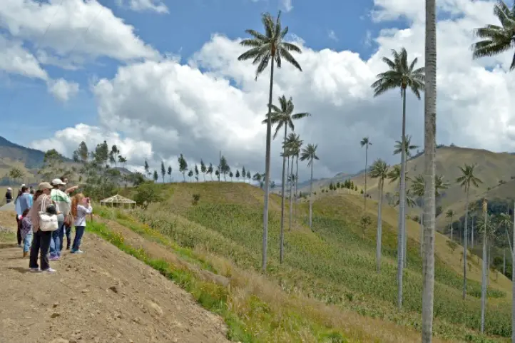
Thousands of tourists travel every year to the Cocora Valley, in the coffee region of Colombia, to admire its impressive palms.
What to do in Cocora Valley
Here you can enjoy the sighting of one of the most beautiful landscapes of Colombia while having a delicious cup of coffee at the Mirador Aires de Cocora. In this place, you can enjoy not only coffee but also delicacies such as passion fruit, cakes, desserts, and sweets to brighten up the afternoon in the company of your family or friends.
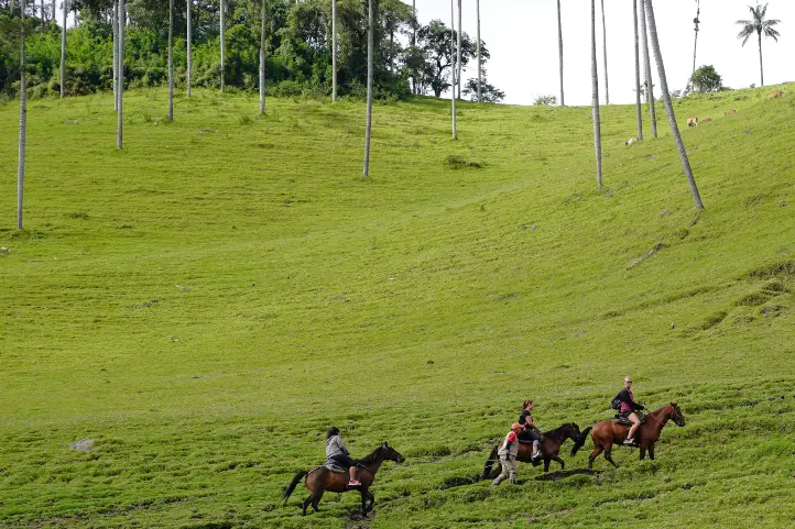
Besides drinking coffee, you can go on a guided horseback ride through the valley and take pictures of the monumental landscapes. Quindío and the Cocora Valley are unique places in the world that deserve to be known, preserved, and admired by all.
Guided horseback ride through the Cocora Valley
But even in this region, the wax palms are scarce. The fact that much of the surrounding forest has been cut down to make way for cattle grazing is part of the reason for their scarcity and, in turn, their threat.
So, if you want to know a real wax palm forest and see the landscape that amazed both explorers, travelers and naturalists, as Mutis and Humboldt, from the eighteenth century to today, I recommend the following destinations below.
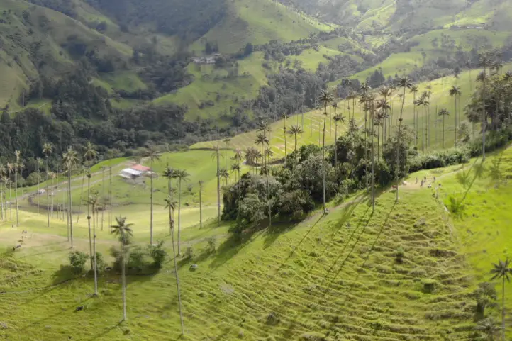
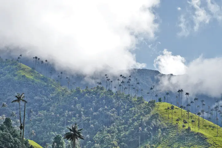
86% of the wax palm forests are found in Toche, being the largest wax palm forest in Colombia and the world, with around 600.000 individuals!
86% of the wax palm forests are found in Toche, Tolima
Toche is a small village hidden between mountains and fog. It is no longer one of the areas of Tolima most affected by the armed conflict. The armed conflict took this region out of the hands of deforestation, and that is why there are very well-preserved high Andean forests.
Today it is a beautiful example of the community’s effort to position this place as a tourist destination of choice.
How to Arrive to Toche
Toche can be reached from Salento, Quindío, by an open road that crosses a moorland area, and gives you the most spectacular views of the cloud forest with wax palms that you can’t even imagine.
You can also arrive from Tolima, from the municipality of Cajamarca. From there you will have to go up to Toche on a very difficult road. It is only possible to go by off-road transport, to make sure you don’t get stuck on the way. This road is also very difficult due to the constant landslides on the mountain slopes.
In Toche you have to visit the Cerro Machín Volcano. This is an active volcano, one of the most dangerous in the world. You can walk to its top, while you find hot springs and clouds of gases released to the surface through mini-craters. You can also walk over the main crater of the volcano, which looks like a swampy area, where you can also observe birds and a forest with wax palms around it.
In Toche, you can also take ecological walks, visit and enjoy hot springs, and do bird watching, especially the yellow-eared parrot.
There are other regions in Colombia where you can find wax palm forests. These are mainly in Caldas, Quindío, Tolima, and Valle del Cauca. However, here I will tell you the most appropriate ones to visit.
You can even find wax palms in cities like Bogota, or Armenia, at the Quindío Botanical Garden. To know more read our entry The Wax Palm and Why it is a Must to See When Visiting Colombia.
San Félix – Caldas
In San Felix is the Samaria Forest, a forest of wax palms. San Felix is a village located at 2,823 meters above sea level in the north of the department of Caldas, 25 km from its municipal capital Salamina and 96.3 km from the capital of Caldas Manizales. Its climate is cold, with an average temperature of 14°C and the temperatures in the early summer go up to 0°C.
It is called “The Paradise of the North”, a name that is due to its landscapes of unparalleled beauty. It has a natural forest of wax palms to which you will arrive by jeep. There you will be received by the peasant community, hard-working, humble, simple, and committed to the region. You will enjoy typical dishes and a guided walk-through path surrounded by wax palms.
The jeep is the car par excellence to move around the Colombian coffee axis.
Tourism is very important as an economic alternative for the cultivation of Hass avocados in this region. This crop is devastating hectares of forest and destroying the habitat of the wax palm in this region.
The Yellow-Eared Parrot Reserve was established by Proaves Foundation in order to guarantee the survival and promote conservation actions aimed at the populations of Yellow-Eared Parrot (Ognorhynchus icterotis) and Wax Palm (Ceroxylon quindiuense), in the areas of Jardín (Antioquia) and Riosucio (Caldas) in Colombia.
Jardín, Antioquia
The Reserve is located in the village of Ventanas, one hour from the town of Jardin (Antioquia), on the road that connects this municipality with Riosucio, Caldas. It has an extension of 188 hectares and presents altitudes ranging from 1,900 to 2,600 meters above sea level. It is classified by the Alliance for Zero Extinction as an AZE site.
Yellow-eared Parrot
This place is the only wax palm sanctuary established in Colombia, but its main goal is to protect the endangered Yellow-eared parrot, a species that nests in the trunks of the wax palm.
According to María José Sanín, a botanist at the CES University in Medellín, the problem is that the palms must be dead since that population of palms is old and is dying massively, which is good for parrots and birders, but terrible for the palms.
What to do in the Reserve
In the Reserve, you can go hiking and bird watching. There are also hummingbird watering places, where the Inca Collared comes.
Current director of Sula. Doctor in Biological Sciences. Her main interests are to explore and understand the organism – environment interactions, taking advantage of emerging knowledge for the management and conservation of species and ecosystem services. She is currently working as a consultant in functional ecology, ecosystem services and conservation projects in Colombia related to ecotourism and birdwatching.
Did you know that Colombia has as many as 5 biosphere reserves? Biosphere Reserves are terrestrial and marine ecosystems protected by the Countries and by the World Network of Biospheres, whose main function is the conservation of the planet’s biodiversity and sustainable use.
The Biosphere Reserves are internationally recognized within the framework of the United Nations Education, Scientific, and Cultural Organization’s (UNESCO)Man and Biosphere Program (MAB).
The Biosphere Reserves form a Global Network in which each country participates on a voluntary basis. Additionally, UNESCO has defined operational guidelines for Biosphere Reserves as a way to ensure better international cooperation. This also takes into account national laws, which play an important role in the status of a biosphere reserve.
But What are Exactly the Biosphere Reserves?
The biosphere reserves are the central instrument of the Man and Biosphere Program (MAB) of the United Nations Educational, Scientific and Cultural Organization (UNESCO), which was established in 1976 to promote sustainable regional development.
Biosphere reserves are extensive and representative areas of natural and cultural landscape, which must be safeguarded in the long term.
Moreover, biosphere reserves must achieve the three fundamental objectives of conservation, development, and logistics as follows:
From conservation, the reserve must ensure the genetic heritage and the refuge of natural and cultural landscapes. In turn, it must safeguard ecosystem services (i.e. clean water, clean air, food, recreation).
From development, it aims to apply sustainable ecological and socioeconomic techniques in all economic sectors.
From logistics, it must facilitate multidisciplinary research and educational activities.
They represent a reservoir of genetic resources and ecosystems and are also areas of sustainable land use, spaces for education, research, and recreation. The biosphere reserves are like “laboratories” where the flora and fauna found in this area are subjects of natural and scientific interest. Additionally, the integrated management of land, water, and biodiversity is studied at these reserves.
The Biosphere Reserves of Colombia
Colombia’s location towards the north of South American region is naturally surrounded by open water from two sides, from the Caribbean Sea and the Pacific Ocean. It also counts with important ecosystems such as the Biogeographic Chocó, the Andean Mountain range, the Eastern plains of Orinoquía, and the Amazon jungle, among the biggest ones.
This privileged biogeographic position of Colombia provides an ideal habitat for a diverse range of flora and fauna to flourish, and that is why it has 5 biosphere reserves that protect important and unique ecosystems existing in the Colombian territory.
Colombia’s Biosphere Reserves Map modified from Google Maps
Needless to say, these reserves surely deserve a visit. Check out this list of the 5 biosphere reserves of Colombia:
The Andean Belt Biosphere Reserve, declared by UNESCO in 1979
Location
The Andean Belt Biosphere Reserve is located in the Colombian massif in the south of the Andes. The Andean belt includes three national parks: La Cueva de los Guacharos Natural National Park, Puracé Natural National Park, and Nevado del Huila Natural National Park.
Highlights
Cueva de los Guacharos Natural National Park
Cueva de los Guácharos NNP was the first area in Colombia to be declared a national park in 1960.
The Cueva de los Guácharos park protects the Andean forest and paramos, from 1200 to 3800 masl. What stands out most is the protection of the extensive and almost extinct areas of Andean oak (Quercus humboldtii Bonpl., Fagaceae) and the endemic oakColombobalanus excelsa Lozano, Fagaceae, a new species of oak described in the park in 1979.
The park owes its name to the guácharo bird (Steatornis caripensis, order Caprimulgiformes, family Steatornithidae). This is a frugivorous, nocturnal bird that lives in caves and hollows. Its name is onomatopoeic, it is derived from the Quechua huach and means to scream or cry, because of its characteristic song. Something very interesting about these birds is that, like bats, they are guided by a system of echolocation.
Puracé Natural National Park
Puracé National Natural Park is a volcanic zone and protects high mountain ecosystems, as well as nationally threatened species such as the Colombian pine (Podocarpus oleifolius), the oak (Quercus humboldtii), the wax palm (Ceroxylon spp), and the tree fern (Cyathea spp), and animals such as the Andean Condor.
Andean Condor
Its name, in the Quechua language, means “mountain of fire”. The main rivers of Colombia are born there: Magdalena, Cauca, Patía and Caquetá and also 30 calm and clear lagoons, ideal for contemplation.
Within its marvelous landscape, the Coconucos volcanic chain rises, also known as the Serrania de los Coconucos, composed of 11 volcanoes. Of these, the most outstanding are the Sugar Loaf (5,000 meters / 16,404 feet above sea level), the Puracé (4,780 meters / 15,682 feet above sea level) that is the only active one, and the Coconuco (4,600 meters / 15,091 feet above sea level).
Nevado del Huila Natural National Park
This snow-capped mountain has the largest glacier in the central mountain range of the Colombian Andes and is the second largest glacier in the country, after Cocuy.
The park shelters a volcanic area with paramo, subpáramo, and Andean forest vegetation. It also overlaps with indigenous reserves in the departments of Tolima and Cauca. This park is closed to tourists.
El Tuparro Biosphere Reserve, declared by UNESCO in 1979
Location
El Tuparro Biosphere Reserve is located in the eastern part of Colombia in the region of Orinoco in the Vichada department. The reserve is surrounded by the Tomo River to the north and the Caño Maipurés to the south. It is one of the few places in the world where the Amazon pink dolphin lives.
The park has numerous trails for bird watching and hiking. In the year 1800, standing in front of the imposing torrent that the natives called Quituna, in awe, the naturalist Alexander von Humboldt, described as the “Eighth Wonder of the World” what is known today as the Raudal de Maypures, one of the main attractions of the protected area.
Tourist Activities
Birdwatching.
Trekking.
Note: It is prohibited to visit the park for sportfishing. Don’t be fooled by unscrupulous offers.
The Sierra Nevada de Santa Marta Biosphere Reserve, declared by UNESCO in 1979
The mountainous system called the Sierra Nevada de Santa Marta is conceived as the ‘Ancestral Territory’ of the original peoples Iku (Arhuaco), Kággaba (Kogui), Wiwa and Kankuamo.
The Sierra Nevada de Santa Marta Biosphere Reserve is a pyramidal territory, isolated from the Andes, and considered the highest coastal mountain in the world. It is located to only 42 kilometers from the sea, and it rises abruptly from the coasts of the Caribbean Sea until reaching a height of 5,775 meters (18,946 feet) in its snowy peaks Bolívar and Columbus.
Sierra Nevada de Santa Marta
Location
To the north it is bordered by the Caribbean Sea and the plains of the Guajira peninsula; to the southeast it is framed by the courses of the Ranchería and Cesar rivers, and to the west, it borders the great alluvial plain of the Magdalena river and the Ciénaga Grande de Santa Marta.
Highlights
For the variety of ecosystems, thermal floors next to the sea, its singular beauty and cultural richness constitute it a unique territory. Its main attraction is a sacred site for the four indigenous peoples of the Sierra, this is the Teyuna Archaeological Park “Lost City”.
Note: Natural National Parks of Colombia and the four indigenous groups of the Sierra Nevada de Santa Marta: Kogui, Arhuaco, Wiwa, and Kakuamo remind us that in the high parts of the Sierra Nevada de Santa Marta, including the lagoons, the páramos and the snow-capped mountains, tourism activities are NOT allowed due to the fragility of these ecosystems and the cultural importance. Entering these sectors constitutes an environmental infraction, according to the provisions of Decree 622 of 1977 – included in Decree 1076 of 2015
Ciénaga Grande de Santa Marta Biosphere Reserve, declared by UNESCO in 2000
The Ciénaga Grande de Santa Marta Flora and Fauna Sanctuary, together with the Salamanca Island Parkway – VIPIS, constitute the Nucleus Zones of the UNESCO-declared Biosphere Reserve and Ramsar Wetland of the Ciénaga Grande de Santa Marta Deltaic Complex.
Both recognitions highlights the importance for conservation of the Ciénaga Grande de Santa Marta at a national and international level. Know more about Ramsar Areas of Colombia in our entry Wetland Destinations in Colombia: Ramsar Areas of Colombia.
Ciénaga Grande de Santa Marta seen from Minca, Sierra Nevada de Santa Marta
Location
This Ciénaga Grande de Santa MartaBiosphere Reserve is located in the Caribbean region of Colombia, in the Department of Magdalena. It covers the municipalities of Ciénaga, Pueblo Viejo, Sitio Nuevo, Remolino, Salamina, El Piñón, Cerro de San Antonio, Concordia, Pivijay, El Retén, and Aracataca.
Highlights
The Ciénaga Grande de Santa Marta Flora and Fauna Sanctuary is formed by progressive accumulations of sediments from the Magdalena River. In turn, it is made up of mangrove ecosystems, swamps, rivers, canals, and marshy areas. It is part of a water complex of more than 100 swamps that present different levels of sedimentation and salinity.
Tourist Activities
Birdwatching.
Community-based tourism.
Note: It is not recommended to camp, nor to spend the night nearby because of the mosquitoes. There is also no place to stay. It is recommended to visit during the day, and stay in Barranquilla or Santa Marta.
Seaflower Biosphere Reserve, declared by UNESCO in 2000
The Seaflower Biosphere Reserve has become one of the most representative icons of marine protection in Colombia.
Conserving this set of ecosystems in the San Andres Archipelago is important for food security. Its economic valuation, because of the environmental services it provides, is estimated at more than $267 billion a year.
This reserve is located in the department of San Andrés, Providencia and Santa Catalina Archipelago.
Highlights
Seaflower is the largest Biosphere Reserve in the world with 180,000 square kilometers. It has all the marine and coastal ecosystems representative of the tropical zone: coral reefs, mangroves, reef lagoons, sea grasses, wetlands, beaches, open sea, and tropical dry forest.
Seaflower Facts
78% of the Colombian coral areas are in Seaflower.
It has the third-largest barrier reef in the world.
It has 57 species of coral, of which 90% are on the Red List of threatened species of the International Union for the Conservation of Nature (UICN).
Also, Seaflower has 407 species of fish, of the 600 estimated to exist in the Caribbean, and is home to 157 species of birds, of which 55% are threatened.
Its white beaches, attractive for tourism, owe their beauty to the calcareous contributions of coral.
It is estimated that its waters annually produce about 156 tons of lobster and 182 tons of fish through traditional fishing.
Old Providence McBean Lagoon National Natural Park
The Old Providence McBean Lagoon National Natural Park is the only nationally protected area in the Oceanic Caribbean of Colombia. It was declared a protected area in 1995, and became part of the “Seaflower” Biosphere Reserve in 2000.
Old Providence McBean Lagoon is formed by a small hill known as Iron Wood Hill, and the McBean Mangrove. In its marine portion, the Barrier Reef stands out, protecting the coasts of Providence Island, which is the second largest in the Caribbean with 32 km in length, after Belize.
This great coral reef, together with the reef lagoon that forms in front of the McBean mangrove, gives the sea a spectacular range of colors that go from deep blue to a translucent aquamarine green. It is thanks to this unique coloring that the Sea of Providence is known as “The Sea of Seven Colors”.
Current director of Sula. Doctor in Biological Sciences. Her main interests are to explore and understand the organism – environment interactions, taking advantage of emerging knowledge for the management and conservation of species and ecosystem services. She is currently working as a consultant in functional ecology, ecosystem services and conservation projects in Colombia related to ecotourism and birdwatching.