Los Colorados Flora and Fauna Sanctuary is the largest and most conserved area of dry tropical forest in the department of Bolivar, in the region of Montes de María, or Serranía de San Jacinto.
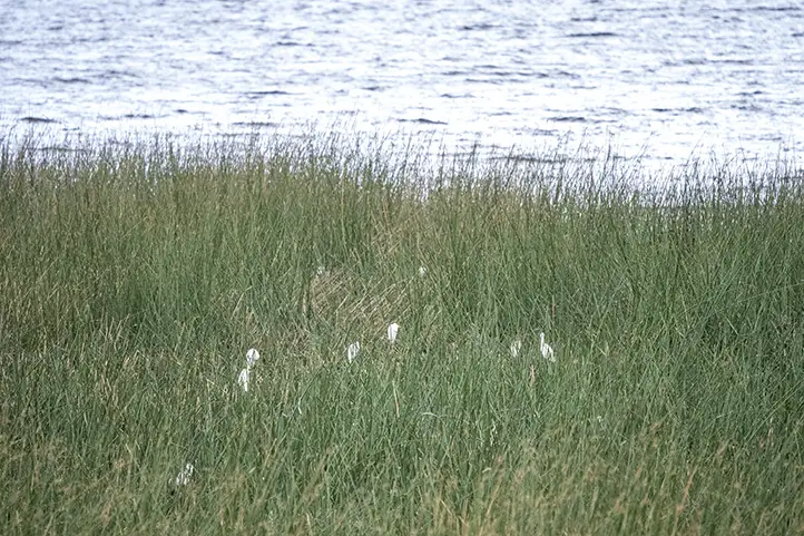
The sanctuary’s name alludes to the presence of the Colombian Red Howler Monkey (Alouatta seniculus), which live along with tamarin monkeys, deer, ocelots, sloths, and other mammals.
This is not a very well known destination among tourists, but it has all the necessary natural attractions to be a very good natural destination, and only 90 km from Cartagena!
Discovering Los Colorados Flora and Fauna Sanctuary
Los Colorados FFS is located in the Colombian Caribbean, in the department of Bolivar, in the municipality of San Juan Nepomuceno. The sanctuary has an area of 10 km².
It contains a representative area of the largest tropical dry forest of the Montes de María or Serranía de San Jacinto, a geological formation isolated between the coastal plain of Bolívar and the savannas of Corozal and Sincelejo.
You will find a small mountain system, with several peaks such as La Cañada, El Escondido, San José, El Yayal, La Gervedera and Tamarindo de Mico.
The sanctuary is also an important provider of water to the region, and there are several mini reservoir built in the surroundings. Los Cacaos and Salvador are two small rivers which flow around the park, there are are also countless creeks that flow into these streams.
A Sanctuary for the Conservation of Tropical Dry Forest and Monkeys
It contains one of the best preserved relicts of dry forest in the region and is an important refuge for the organisms of this habitat, such as some primate and mammal populations.
Los Colorados FFS as an Important Bird Area
The Galeras FFS is an Important Bird Area (IBA/AICA) recognized by BirdLife International, since Globally threatened species and Restricted-range species are present in the area. It is also a feeding station for migratory birds and it has more than 280 reported bird species, 46 of which are migratory.
Archeological Importance
Within the sanctuary’s facilities you can visit places of great cultural importance such as ceremonial sites of local indigenous communities.
The Malibú Mokaná or Malibú Serraneros ethnic group inhabited this area in the past XVI century. You can see some archaeological vestiges found in the area of influence of the Sanctuary, such as ocarinas and petroglyphs, and also the well-known “centellas” stones.
The inhabitants of the region have established an important relationship with Los Colorados hill, impregnated with beliefs and cultural practices evident, for example, in the treatment given to medicinal plants.
How to get to Los Colorados Flora and Fauna Sanctuary
Bogotá – Cartagena – San Juan Nepomuceno
Take a 45- minutes flight from El Dorado Bogotá (BOG) to Rafael Nuñez International Airport (CTG) at Cartagena city.
From Cartagena take the road to Sincelejo passing through the towns of Turbaco, Arjona, Sincerin, El Viso, Malagana, San Cayetano and Carreto until you reach the municipality of San Juan Nepomuceno, 90 kilometers from Cartagena.
From there you can access the entrance road to the eastern side of the Sanctuary by motorcycle or vehicle (5 minutes) or walking (20 minutes) to the operational headquarters.
What to do in Los Colorados Flora and Fauna Sanctuary
The Sanctuary and surrounding area is an ideal destination for photography, bird watching, and enjoying the natural beauty and culture of the region.
Hiking
As a visitor you can tour the mountain from east to west, through trails such as ‘El Yayal’ or ‘Planeta Bosque’, along the banks of Los Cacaos stream, paths to bring out the wild soul and become environmentally conscious.
You can visit the following tourist attractions within the sanctuary: Los Chivos waterfall, El Mirador, Los Cacaos stream, Escondido gully, Tigre’s cave, Piedra del Toro and Tinamú.
Planeta Bosque Trail
Planeta Bosque is an interpretative trail, which has a duration of 3 to 5 hours with a low degree of difficulty. It is ideal for bird watching.
Birdwatching
The number of bird species recorded in the sanctuary is 152 species divided into 40 families. Among the species that you can see are:
Macaws (Ara macao, Ara chloropterus, Ara severus, Ara ararauna)
Guans (Penelope purpurascens)
Chachalacas (Ortalis ruficauda)
Red-throated caracara (Ibycter americanus)
Toucans (Ramphastos sulfuratus).
Black-crested antshrike (Sakesphorus canadensis)
Wildlife Tours
Los Colorados FFS is considered a great refuge for species characteristic of the local dry forests, there are records of more than 40 mammals. Among the species of mammals that can be seen are:
Alouatta seniculus
Saguinus oedipus
Bradypus variegatus
Choloepus hoffmanni
Pecari tajacu
Dasyprocta punctata
Leopardus pardalis
Leopardus wiedii
Potos flavus
The sanctuary is also the transitory habitat of the Jaguar (Pantera onca).
Los Colorados FFS has records of 29 amphibian species, 20 genera and 10 families, and 21 families of reptiles.
Where to stay in Los Colorados Flora and Fauna Sanctuary?
Los Colorados FFS does not currently offer lodging services for visitors. But it is very close to the towns of San Juan Nepomuceno and San Jacinto where you can stay. Our recommendations for you are:
San Juan Nepomuceno: Hotel Malibu
San Jacinto: Bello Horizonte and Hostal las Palmas
Best time to visit Los Colorados Flora and Fauna Sanctuary
It is recommended to visit the park during the 2 dry seasons, between the months of December and April, and between July and August.
Los Colorados Flora and Fauna Sanctuary Entrance fees
These are the entrance fees for 2021:
Los Colorados FFS has a single entrance fee of COP 6,500.
Children under 5 years old and Colombians over 65 years old have free admission upon presentation of their identity documents.
What to consider before visiting Los Colorados Flora and Fauna Sanctuary
You should wear long pants, t-shirt or long sleeve shirt and comfortable shoes. In the rainy season, we recommend marsh boots.
The entry of pets or domestic animals is prohibited.
The use of flash when taking photographs is prohibited.
Use of binoculars to watch animals’ behavior is recommended.
Bring along valid identification documents and health insurance.
It is recommended to be vaccinated against yellow fever and tetanus.
If you take specific medications, take them with you a personal first aid kit.
Some prohibitions
Feeding, bothering or hunting animals, alcoholic drinks and drugs, throwing cigarette butts, burning garbage, felling, and capturing wildlife.
References
Colparques
Parques Nacionales
About the authors
Luisa Martin
Engineer, world traveler, amateur photographer, traveling blogger, and foody.
The Isla de la Corota Flora Sanctuary, which from a distance looks like the shell of a large turtle about to emerge from the water, is located in the north of Lake Guamués or Laguna de la Cocha, in the department of Nariño in southwestern Colombia. It is a beautiful island full of orchids as nowhere in the whole in the country.
In this publication you will find the information and recommendations you need for your visit to the smallest protected area in Colombia.
Discovering Isla de la Corota Flora and Fauna Sanctuary
La Cocha Lagoon, where is placed Isla de la Corota, is a wetland of international importance declared by the Ramsar Convention, for more information about RAMSAR sites in Colombia click here. The lagoon was formed by tectonic movements and later filled with water from the paramos and surrounding areas. Placed in the middle is Isla de la Corota island, formed million of years ago by volcanic activity, standing out as an immense tortoise shell.
Isla de la Corota has a total area of just 0.16 km² and is part of the jurisdiction of the municipality of Pasto, the capital city of Nariño, located in the town El Encano, where El Puerto is located, a picturesque pier surrounded by lodgings and restaurants whose specialty is the preparation of rainbow trout.
The sanctuary is part of the Andean insular lacustrine forest ecosystem, which leads to the formation of a very humid forest and its thermal floor is also very cold, which is why there is constant rainfall in this sector. The oval island is surrounded by a fringe of reeds (Schoenoplectus californicus) and although it is the smallest protected area in the country, it is part of the important and complex environmental system of the Cocha Lagoon.
Cultural Importance of Isla de la Corota
Isla de la Corota is the smallest protected area in the country, for being a wetland of great importance, it is part of the complex environmental system of the Laguna de la Cocha. Its recognition is not only due to its natural value, but also to its cultural and historical value for the indigenous people and traditional doctors.
The island is a source of energy recognized by Putumayo’s indigenous people and traditional doctors. It also has a chapel that is an important pilgrimage site for Catholics, especially during the Feast of the Virgin of Lourdes.
How to get to Isla de la Corota Flora and Fauna Sanctuary
Bogotá – Pasto
Take a 1,5-hours flight from Bogotá to Antonio Nariño Airport (PSO) at Pasto city. Once at the airport, take an approximately 2-hours ride to El Encano Town. At El Encano take an extra 20- minutes boat ride to Isla de la Corota Flora Sanctuary.
What to do in Isla de la Corota Flora and Fauna Sanctuary
You can take a boat tour through the waters of La Cocha, and enjoy hiking and birdwatching activities. Enjoy the nature that embellishes this place. Once there, you will find the Sanctuary has a 500-meter long trail that crosses it from side to side through the dense forest. You will find typical trees of the Andean forest, as well as orchids and ferns that complete a beautiful natural picture.
Hiking
For hiking lovers, this Sanctuary has the El Quiche Trail (550 m, medium difficulty) that crosses the island from north to south through a dense forest of cold thermal floor, and the La Torota Trail (200 m, low difficulty), which allows observing the aquatic ecosystem with its diverse species.
El Quiche trail
It has a distance of 500 meters of medium intensity, where you can tour the island from north to south and visit the beautiful viewpoint where you can appreciate the beauty and immensity of the Laguna La Cocha along with the sounds of birds.
La Totora Trail
This trail has 200 meters of low intensity, where you can appreciate the aquatic ecosystem as well as visit the sanctuary’s resident and migratory bird sanctuary. Totora refers to the reeds (Schoenoplectus californicus) that surround Isla de la Corota Sanctuary
Fringe of reeds (Schoenoplectus californicus) around Isla de la Corota Sanctuary
Sanctuary of the Virgin of Lourdes
On the island there is also a Sanctuary of the Virgin of Lourdes, where devotees go to pray and serves as gathering for thousands of believers that annually come to pay their respect to the Virgin.
Birdwatching and Wildlife Observation
Despite the sanctuary’s size, it has an important presence of birds. There is a variety of species that live there, such as sparrows, cockatoos, and blackbirds, among others. There also inhabit three species of bats and one species of wild mice. The sanctuary has a record of 77 bird species, 22 of which are aquatic species and the remaining 55 are terrestrial.
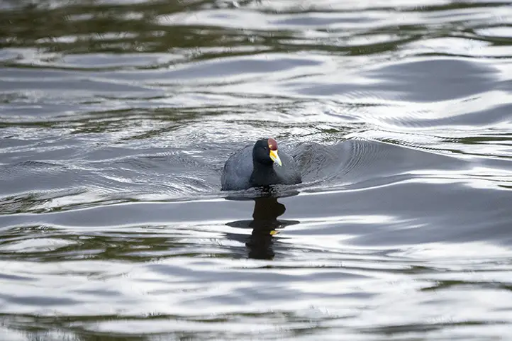
Slate-colored Coot – Fulica ardesiaca at La Cocha Lagoon
Also, depending on the season in which you visit the sanctuary, you will be able to see migratory birds.
You will also find a great variety of butterflies and 8 species of amphibians belonging to the Pristimantis genus.
Orchids Tour
Moreover, the sanctuary has 341 species of flora belonging to 87 families, including bromeliads, anthuriums, ferns, mosses, lichens, and orchids. In the case of orchids there are 36 species that can be seen on your tour.
Where to stay in Isla de la Corota Flora and Fauna Sanctuary
Around La Cocha lagoon it is possible to stay according to your preferences. Available accommodation options include the Sindamanoy Hotel, In Vereda El Puerto, 370 meters from the sanctuary’s shore, with a Swiss architecture offering single and multiple accommodations.
Best time to visit Isla de la Corota Flora Sanctuary
The sanctuary can be visited all year round, but since it is a cold climate it can rain almost every month. July to September is when it rains the least, with an average temperature of 14º C (57 ºF).
Isla de la Corota Flora Sanctuary Entrance fees
The entrance fee varies depending on the nationality and age of the visitors. The transportation service from El Puerto has a cost of $35.000 round trip in handmade boats.
These are the entrance fees for 2021:
Colombians, foreigners holding valid residence permits and tourists from Bolivia, Ecuador and Peru (ages 5 to 25): COP 5,500.
Colombians, foreigners holding valid residence permits and tourists from Bolivia, Ecuador and Peru (over 25 years old): COP 5,500.
Non-resident foreigners (over 5 years old): COP 10,500.
Children under 5 years old and Colombians over 65 years old have free entrance presenting their IDs.
What to consider before visiting Isla de la Corota Flora and Fauna Sanctuary
Wear warm clothes, gloves and scarf, comfortable shoes, preferably closed, tennis shoes or boots without high heels for the El Quiche trail.
Avoid consuming food or beverages of any kind during the tour on the trail.
The use of electronic devices that produce noise and disturb the tranquility of the place is prohibited.
Since the La Totora trail also serves as a dock for visitors to disembark, it is very important to be careful with children during the tour since there are only handrails on the inner side of the trail.
Be careful with personal objects (bags, clothes, cell phones, cameras, etc.); the administration is not responsible for objects left in the protected area.
Only walk along the marked trails; going into the forest causes impacts that go against the conservation objectives.
The entrance of pets or domestic animals (dogs, cats, etc.) is prohibited because of their natural behavior, they create impacts on the little fauna in the forest, we recommend looking for alternatives to not include them in your visit.
Some prohibitions
Feeding, bothering or hunting animals, alcoholic drinks and drugs, throwing cigarette butts, burning garbage, felling, and capturing wildlife.
References
Castro J, Jojoa R, Delgado D, Villarreal M F (2020). Avistamiento de aves en el Santuario de Flora Isla de la Corota. Parques Nacionales Naturales de Colombia. Occurrence dataset https://doi.org/10.15472/xyzi2q accessed via GBIF.org on 2021-06-30.
Parque Nacionales Website
SITUR Nariño
About the authors
Sara Colmenares
The current director of Sula. Doctor in Biological Sciences. Her main interests are to explore and understand the organism-environment interactions, taking advantage of emerging knowledge for the management and conservation of species and ecosystem services. She is currently working as a consultant in functional ecology, ecosystem services, and conservation projects in Colombia related to ecotourism and birdwatching.
Luisa Martin
Engineer, world traveler, amateur photographer, traveling blogger, and foody.
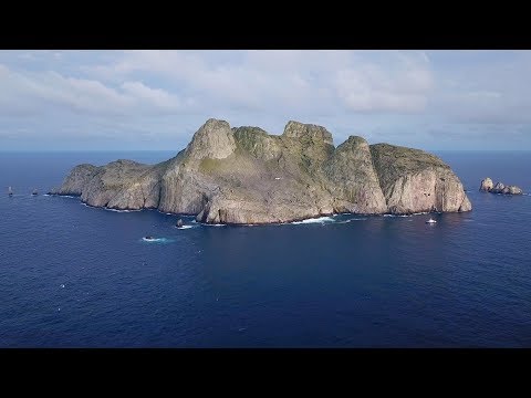
On the Pacific Ocean, 507 km west of the port of Buenaventura, is the island of Malpelo. It is the only oceanic island of the Pacific Ocean and belongs to the marine corridor of the eastern Pacific Ocean with 11 emerged islets.
The charm of Malpelo lies beneath the surface of the sea. Thanks to its location and great variety of marine flora and fauna Malpelo is among the 5 most beautiful and exotic places in the world to practice scuba diving.
The characteristics of the marine environment are strongly influenced by the type of currents that run through this area of the Pacific. Malpelo is the point of confluence of different and important currents of the Pacific Ocean.
The encounter between the cold currents of the southern hemisphere and the warm equatorial currents makes its waters very rich in nutrients. Because of this, Malpelo is home to an incredible amount of fauna: hundreds of Green Moray Eels that swim in open waters, schools of barracudas, turtles, dolphins, manta rays in solitary and in groups, rays, longfins, and huge schools of mackerels.
Malpelo is also the sharks paradise, and this is the main reason that makesMalpelo a unique place in the world, with large concentrations of Silky Sharks (Carcharhinus falciformis) and Hammerhead Sharks (Sphyrna lewini), among others.
Discovering Malpelo Flora and Fauna Sanctuary
The Malpelo Flora and Fauna Sanctuary is located on the unique submarine volcanic mountain range, Dorsal de Malpelo. The highest point is Cerro la Mona 300 meters above sea level, this marine mountain range has a length of 150 miles and 50 miles wide.
Voluminous eruptions of basaltic lava gave birth to this island. The islets that surround the island seem to be the result of erosion processes caused by the waves, causing them to be lifted by tectonic effects. This process forms terraces known as “Strath Terraces”.
Malpelo Flora and Fauna Sanctuary was declared a protected area in 1995 and has had 3 expansions in the years 1996, 2006 and 2017 with a total of 1.7 million miles.
In 2005 it was named an Important Bird Conservation Area (IBA) by BirdLife International and the Alexander Von Humboldt Research Institute. In 2006, UNESCO declared the sanctuary a Natural World Heritage Site, and today it is a Mission Blue hotspot.
Malpelo Flora and Fauna Sanctuary has one of the most important coral formations of the Colombian Pacific; the marine fauna is very varied on the island, and in this sanctuary you can find 2 species of starfish endemic to the country. In addition to this, one of the most important hammerhead shark breeding areas in the world is located in Malpelo Flora and Fauna Sanctuary.
Unfortunately, the sanctuary is constantly harassed by illegal fishermen, which mainly affects hammerhead sharks and hawksbill turtles. In addition, overfishing in zones of influence within the protected area’s limits, such as for tuna, can reach alarming numbers, endangering the decline of the tuna communities.
The Malpelo y Otros Ecosistemas Marinos Foundation, is in charge of promoting the protection and care of marine areas, especially sharks, so that they have a safe habitat for their reproduction. They work together with the national parks system and the national navy.
How to get to Malpelo Flora and Fauna Sanctuary
Bogotá-Buenaventura
The only way to access the sanctuary is by sea, after a 36-hours open sea journey from the city of Buenaventura. Take a 145- minutes flight from Bogotá to Alfonso Bonilla Aragón International Airport (CLO) at Palmira city. Once at the airport, take an approximately 3- hours ride to Buenaventura.
What to do in Malpelo Flora and Fauna Sanctuary
Diving and snorkeling
The sanctuary has the following areas for these activities: La gringa, Escuba, Los Reyes, Los gemelos, Sahara, Vagamares, El arrecife, La nevera, Monster face, El mirador, El Freezer, Aquarium, Naufragio wall, Bajo del ancla and Bajo del Monstruo.
These areas have the optimal conditions for a unique experience. You must keep in mind that if you want to do these activities you must have previous knowledge.
Wildlife
The biological component in the terrestrial environment of Malpelo Island is represented by algae, lichens, mosses, some grasses, shrubby legumes and ferns. Seabirds provide guano that acts as fertilizer along with the rain to generate a food source for the invertebrates that inhabit the island.
Ants such as the trap jaw ants (Odontomachus baur), which is considered to have been introduced to the island by man, can be found throughout the sanctuary. It is also possible to find a new species of beetle from the Platynus genus, which is unusual and can be found in Colombia and Ecuador.
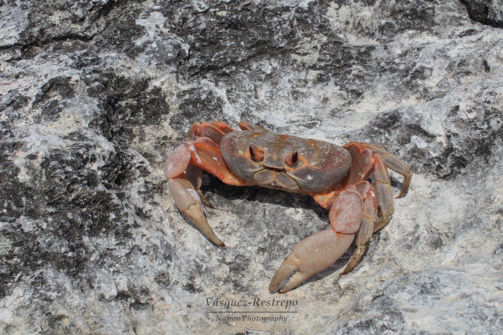
Johngarthia malpilensis – Ph. by Daniel Vásquez-Restrepo CC
On the island, it is also possible to observe the terrestrial crab Johngarthia malpilensis, which is also endemic to the island. Besides this, several other species of crabs also live on the hard substrates, and there are around 270 species of gastropods, 60 of bivalves, 3 of cephalopods, 2 of Scaphopods, and 6 of Polyplacophorans.
Four species of reptiles inhabit the sanctuary:
Anolis agassizi, from the equator, feeds on the remains and food waste of seabirds.
Dactyloa agassizi is one of the island’s endemic lizards, greenish in color. It feeds on insects and crabs.
Diploglossus millepunctatus is also an endemic lizard of the island. Its diet is based on the remains of seabirds and in case of food shortages they can break their eggs and consume them together with the dead hatchlings.
Phyllodactus traversalis, known as the geko lizard, joins the sanctuary’s endemic species. It has nocturnal feeding habits based on insects, but during the day it takes refuge in rock crevices.
Malpelo has a wide variety of marine birds, making it an excellent place for bird watching. The bird with the largest representation is the Nazca booby (Sula granti). A third to a quarter of the total breeding population of this species worldwide nests in the Island of Malpelo.
The Biological Component in the Marine Environment
You will see different specie in the rocky walls of Malpelo depending on the depth. From 3 to 6 meters the walls are covered by sponges and some corals, such as the Tubastrea aurea. After 27 meters it is possible to see filamentous algae and violet hydro corals.
In the depths of the sanctuary there are submarine terraces divided into 4 sectors; the slopes of these sectors are the areas where the coral communities are most present. The four sectors are located as follows:
“El Arrecife”, it is the most extensive and is located to the northeast of the island.
“Pared del Náufrago” (Castaway’s Wall), located to the northwest.
“La Bahía de la Nevera” to the west, and “El Bajo de la Nevera” to the southwest.
“El Bajo de Junior” to the southwest.
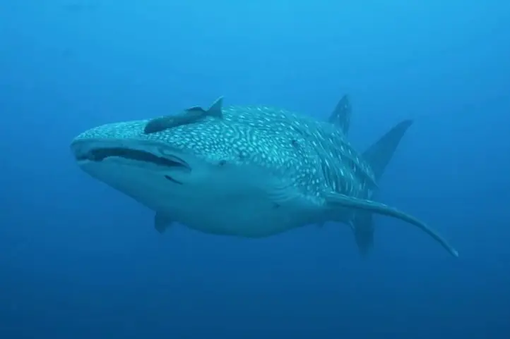
Whale shark (Rhincodon typus) CC Ph. By Sandra Bessudo, Malpelo Foundation
The sanctuary has identified 390 reef fish species and 5 of these species are endemic: Halichoeres malpelo, Axoclinus rubinoffi, Lepidonectes bimaculta, Chriolepis lepidotus, and Acanthemblemaria stephensi.
Pelagic fish, mammals, and sea turtles aggregate in the sanctuary, and it is considered a passageway for migratory species such as tuna, which feed in the sanctuary’s environment during their migration.
There are two species of sharks that can be seen during the visit: hammerhead shark (Sphyrna lewini) and Galapagos shark (Carcharhinus galapagensis). The cleaning zones in Malpelo are inhabited by the barberfish (Jhonrandallia nigrirostris), the king angelfish (Holacanthus passer) and juveniles of mexican hogfish (Bodianus diplotaenia).
Due to the large number of larvae present in the sanctuary, it is possible to see whale sharks (Rhincodon typus) and manta rays (Manta birostris), which can be frequently sighted along with communities of common bottlenose dolphins (Tursiops truncatus).
Where to stay in Malpelo Flora and Fauna Sanctuary
Malpelo Flora and Fauna Sanctuary does not have lodging available, you will stay on boat.
Best time to visit Malpelo Flora and Fauna Sanctuary
Malpelo Island can be visited all year round, it has humidity in the air and remains covered by a dense mist. The months with the lowest humidity are between December and March.
Malpelo Flora and Fauna Sanctuary Entrance fees
The entrance fee varies depending on the nationality and age of the visitors. These are the entrance fees for 2021:
Colombians, foreigners holding a valid residence permit, and tourists from Bolivia, Ecuador and Peru (over 25 years old): COP 116.000 (Diver/day); COP 79.000 (Instructors for accompanying groups/day): COP 35.500 (Boats/day)
Non-resident foreigners (over 25 years old): COP 216.000 (Diver/day); COP 116.000 (Instructors for accompanying groups/day): COP 65.000 (Boats/day)
What to consider before visiting Malpelo Flora and Fauna Sanctuary
To dive in Malpelo there must be one certified guide with experience in the area for every six divers.
Tourists must be certified as advanced divers or two-star divers, and have a minimum of 35 dives in their logbook, information that will be corroborated by the National Parks official in the protected area.
The maximum diving depth allowed is up to 140 feet.
Each diver must have the minimum equipment for underwater activities and safety equipment.
Minors must have written permission from their parents, even if they are accompanying them.
It is important to ensure buoyancy control as a measure to avoid damage to ecosystems, and to refrain from feeding, chasing or touching marine fauna. Therefore, a buoyancy check dive is done to verify the diver’s ability.
Avoid carrying harmful elements that threaten the health of ecosystems such as CFC aerosols, and non-biodegradable cleaning products.
Diving activities are programmed from 8:00 a.m. to 5:00 p.m., all within a previously defined schedule and depending on weather and oceanographic conditions.
Recommended the use of binoculars to admire animals’ behavior and beauty in their natural habitat.
Carry valid identity documents and health insurance. It is recommended to be vaccinated against yellow fever and tetanus.
If you take specific medications, take them with you.
Some prohibitions
Feeding, bothering or hunting animals, alcoholic drinks and drugs, throwing cigarette butts, burning garbage, felling, and capturing wildlife.
If you want to plan your trip to Colombia do not hesitate to contact us, visit our Plan your trip page!
Engineer, world traveler, amateur photographer, traveling blogger, and foody.
Sara Colmenares
The current director of Sula. Doctor in Biological Sciences. Her main interests are to explore and understand the organism–environment interactions, taking advantage of emerging knowledge for the management and conservation of species and ecosystem services. She is currently working as a consultant in functional ecology, ecosystem services, and conservation projects in Colombia related to ecotourism and birdwatching.
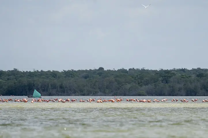
Los Flamencos Fauna and Flora Sanctuary is an important reserve with marshes, lagoons, and an important fragment of tropical dry forest created to protect a large population of American flamingos (Phoenicopterus ruber). This reserve is also the habitat of 185 other bird species, 80% of which are migratory.
Los Flamencos has shallow lagoons that fill up when the rains come and evaporate during the dry season. When the water evaporates, the marine salt concentrates, facilitating the growth of brine shrimp (Artemia sp.), which attracts American flamingos!
The local community consists mainly of Wayuu Indians. They are known for their colorful bags (mochilas), and handicrafts.
Discovering Los Flamencos Fauna and Flora Sanctuary
Los Flamencos Fauna and Flora Sanctuary is formed by four coastal swamps, with an area of 768. 2 square kilometers. It was declared Colombia’s National and Cultural Patrimony in 1992, being one of the smallest protected areas in the country, but one of the richest in a variety of resident and migratory birds. Moreover, it is home to algae, mollusks, crustaceans, and fish.
Temperature varies from 26 to 33 degrees celsius at its highest point.
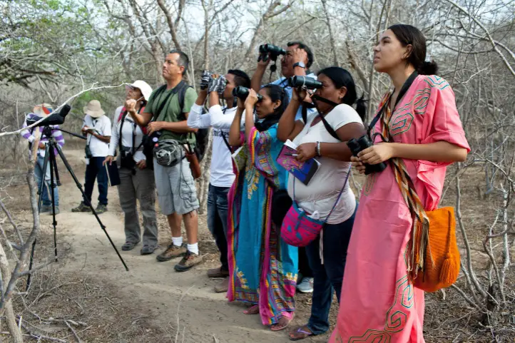
Picture from Audubon: “Wayuu indigenous students and teacher Alvaro Jaramillo are bird watching in La Guajira, Colombia. The program teaches locals to become tour guides for travelers interested in spotting birds. Photo: Carlos Villalon”
Los Flamencos Sanctuary offers diverse cultural and gastronomic options, especially, from local Wayuu. Worth noticing is the ancestral dances and “make-up” worn by Wayuu people from the nearby rancherias tribes.
In the case of Los Flamencos Flamingo Fauna and Flora Sanctuary, they offer a year of work to a representative of each of the tribes present in the sector. There are 7 tribes and two of them are selected annually to provide information and orientation to the sanctuary’s visitors with the support of a representative from the national natural parks in the city of Bogota.
Food delicacies available include different types of fish, seafood, and goat meat, prepared with the region’s ancestral recipes.
The American Flamingo
These beautiful birds with pink feathers, long legs, and slender long- curved necks, are by far the most interesting attraction in this place. In fact, the park is named after these birds.
Flamingos are monogamous birds that lay only one egg per year. Their nests are mud mounds with a height of approximately 30 to 55 cm. Its hatchlings are born with white or grey feathers and they must wait 3 years for their feathers to turn pink.
Note that flamencos are easier to watch during the rainy season.
American Flamingo – Phoenicopterus ruber at Los Flamencos Fauna and Flora Sanctuary, Colombia
Why are Flamingos Pink?
Remember the shrimps we mentioned above? Flamingos get their pink color from the consumption of those brine shrimps, which are rich in beta carotene, a red-orange pigment.
Archaeological ruins
Other than flamingos, this place hosts archaeological ruins that confirm the presence of the “Guanebucans”, pre-colonial fishing and farming communities in the area that belong to the Arawak family.
These pre-colonial communities were forced to immigrate to the high areas in the Sierra Nevada, approximately 100 km west, after Spanish incursions.
How to get to Los Flamencos Fauna and Flora Sanctuary
From Bogotá
Take a 1.5 hours flight from Bogotá to Almirante Padilla International Airport (RCH) at Riohacha city. From Riohacha take an approximately 40 minutes ride to Camarones hamlet (20 km).
Once at Camarones hamlet you should walk along a trail for 3.5 km to the administrative center of the Park: Cabaña Guanebucane.
From Santa Marta
Take an approximately 2,5 hours ride to Camarones (165 km). From Camarones walk along 3.5 km trail to the administrative center of the Ministry of the Environment, Cabaña Guanebucane.
What to do in Los Flamencos Fauna and Flora Sanctuary
Hiking
Los Flamencos Fauna and Flora Sanctuary have a 2-hour trail through the Navio Quebrado lagoon. Then, hop on a water canoe and adventure yourself. During the tour enjoy the wonderful Caribbean Sea and the snow peaks of Colón and Bolivar, both part of the Sierra Nevada de Santa Marta.
Wildlife Observation
At Los Flamencos Sanctuary it is possible to find mixt of fresh and saltwater, which makes the whole ecosystem very diverse. Unique habitats such as tropical dry forest and tropical very dry forest that host wonderful species are present.
The sanctuary is characterized as an important migratory stop for turtles such as the leatherback sea turtle (Dermochelys coriacea), the loggerhead sea turtle (Caretta caretta), the hawksbill sea turtle (Eretmochelys imbricata), and the green sea turtle (Chelonia mydas)
At the time of rising tides, the shrimps begin their reproductive migration process.
In the rainy season, it is possible to appreciate the foliage of the beautiful yellow flower of the Puy (Handroanthus billbergii). Additionally, the place is host to the most diverse ecosystem of plants, such as the black mangrove (Avicennia germinans), the Dulce (Conocarpus erectus), the white mangrove (Laguncularia racemosa), and, to a lesser extent, the red mangrove (Rhizophora mangle).
Birdwatching
It is possible to appreciate the pink flamingos (Phoenicopterus ruber ruber) resident in the sanctuary. However, there are plenty of birds you can see around. Ibis, gulls, terns, and many migratory shorebirds are to be found at Los Flamencos.
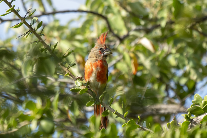
Vermilion Cardinal – Cardinalis phoeniceus
In the forest, you will find specialties restricted to NE Colombia and NW Venezuela, including Rufous-vented Chachalaca, Bare-eyed Pigeon, Buffy Hummingbird, Russet-throated Puffbird, Chestnut Piculet, White-whiskered Spinetail, Slender-billed Inezia, Orinocan Saltator, Pileated Finch, Tocuyo Sparrow, Crested Bobwhite, Blue-crowned Parakeet, Brown-throated Parakeet, Green-rumped Parrotlet, Black-crested Antshrike, White-fringed Antwren and Northern Scrub-Flycatcher, and the Vermillion Cardinal.
The Vermilion Cardinal is called “Rey Guajiro” (“King of the Guajira”) by the Wayuu people, and it is very important for their culture and traditions.
Where to stay in Los Flamencos Fauna and Flora Sanctuary
Camarones town offers different types of accommodation. Our suggested choices are:
Playa Samara Hostel, 14 kilometers away from the Sanctuary entrance.
Mar Azul-Playa Hotel, 12 kilometers away from the Sanctuary entrance.
You can also stay in Riohacha. Our suggested choice is Hotel Taroa.
Best time to visit Los Flamencos Sanctuary
The dry season is around December to late April and from July to late August and is the most convenient. But the dates when you will see the largest amount of pink flamingos is from October to late November.
Entrance fees
The entrance fee to The Flamencos Fauna and Flora Sanctuary is free. However, since it is located inside an indigenous territory, they ask you for a little representative payment.
What to consider before visiting Los Flamencos Sanctuary
Return ALL garbage you generate during the tour with you and dispose of it at the waste disposal sites.
Entrance for children under 5 years old, pregnant women, people with heart or respiratory conditions are not recommended.
Any guided tours must be done with authorized and certified tourist guides.
Always travel along the paths and trails marked by local authorities.
Be respectful of the Wayuu culture, its territories, and nature.
Consider wearing personal protective items (sun blocker, sunglasses, towel, insect repellent, and hat).
Carry reusable water bottles.
Bring along enough water for the journey (at least 1.5 liters).
Do not use flash when taking photographs.
Use of binoculars to admire animal behavior and beauty in their natural habitat.
Carry valid identity documents and health insurance.
It is recommended to be vaccinated against yellow fever and tetanus.
If you take specific medications, take them with you. It’s never enough to carry a personal medicine kit.
Some prohibitions
Feeding, bothering or hunting animals, alcoholic drinks and drugs, littering, burning garbage, felling, and capturing wildlife.
Engineer, world traveler, amateur photographer, traveling blogger, and foody.
Sara Colmenares
The current director of Sula. Doctor in Biological Sciences. Her main interests are to explore and understand the organism–environment interactions, taking advantage of emerging knowledge for the management and conservation of species and ecosystem services. She is currently working as a consultant in functional ecology, ecosystem services, and conservation projects in Colombia related to ecotourism and birdwatching.
Colombia is the second most biodiverse country in the world —and the most biodiverse country per square meter—. This is a privilege not many countries have and Colombia understands how lucky it is for its natural richness.
In fact, it has a National System of Protected Areas (SINAP in Spanish) with a huge network of national parks and sanctuaries. SINAP is a program that protects 1.116 areas equivalent to 15% of the national territory. It includes all protected areas under public, private or community governance and under national, regional or local management.
The National Natural Parks System
Within the system, there is an entity in charge of managing the protected areas and implement the required policies and strategies to pursue the goal of nature conservation in the country.
It is called the National Natural Parks System and comprises 59 natural areas that represent over 14,200,000 hectares (+142,000 km2) of the national area (land and marine).
The Colombian cultural wealth is also present in the system, as 26 out of the 59 areas are inhabited by indigenous and Afro-descendant peoples.
These protected areas are divided into 5 categories:
National Natural Park (PNN),
National Natural Reserve (RNN),
Unique Natural Area (ANU),
Fauna and Flora Sanctuary (SFF), and
Parkway (Vía Parque).
We will focus on defining the national parks and the sanctuaries.
National Natural Park (PNN): extension area whose ecosystems have not been substantially altered by human occupation or exploitation, that can have ecological self-regulation and whose plant and animal species, geomorphological complexes and historical or cultural manifestations are of scientific, educational, aesthetic and recreational value.
Fauna and Flora Sanctuary (SFF): area dedicated to the preservation of wild animal and plant species or communities to conserve genetic resources of the national fauna and flora.
There are currently 23 stunning parks and sanctuaries you can visit, since they are open for ecotourism and offer several activities for a respectful interaction with nature.
Read on to know about the open national parks that shelter Colombia’s biodiversity!
Ecotourism in National Natural Parks
In Colombia you can find a variety of climates, landscapes, flora and fauna depending on the region you are traveling. There are 6 natural regions and each of them host several national natural parks that offer ecotourism possibilities.
This region comprises the islands and cays that belong to Colombia’s territory in the Caribbean Sea and the Pacific Ocean. The most famous ones are San Andres, Providencia and Santa Catalina islands, El Rosario islands, Gorgona and Malpelo. In each of these islands, there is a protected area, due to the high diversity of fauna and flora that inhabit ecosystems such as colorful coral reefs and tropical rainforests.
Old Providence McBean Lagoon National Natural Park
Area
1,648 ha
Altitude
0 – 80 m.a.s.l
Temperature
Warm weather 25°C (77°F)
Status
Open to the public
Entry fee
Non-resident foreigners over 5 years old COP $19,000
Facilities
Accommodation and restaurant services on Providencia and Santa Catalina islands.
The small Iron Wood Hill, surrounded by the McBean mangrove swamp, makes up the Old Providence McBean Lagoon National Park.
It protects nothing but the second largest coral reef in the Caribbean, and this formation along with the reef lagoon in front of the mangrove produce in the sea an array of colors from deep blue to translucent aquamarine that gives it the name of “the sea of 7 colors”.
Corales del Rosario y de San Bernardo National Natural Park
Area
120,000 ha
Altitude
0 m.a.s.l – 50 m deep
Temperature
Warm weather, 27 – 30°C (80.6 – 86°F)
Status
Open to the public
Entry fee
Non-resident foreigners over 5 years old COP $9,500
Facilities
Accommodation in rooms, hammocks or camping zone, restaurant. Services provided by the community business Nativos Activos.
South of the walled city of Cartagena, this National Park lies and covers 4 islands and a large marine zone in the Caribbean Sea. What you can find here is the most extensive and diverse coral reef in the entire Colombian Caribbean continental coastline.
Colorful organisms give life to the ocean of crystal-clear water and white-sand beaches, as unique mangroves and sea grasses complement the landscape.
Notice: It is advised to be vaccinated against yellow fever 10 days before the planned trip date and carry immunization records.
Malpelo Flora and Fauna Sanctuary
Area
2,667,907 ha
Altitude
0 – 330 m.a.s.l
Temperature
Hot and humid weather 25°C (77°F)
Status
Open to the public
Entry fee / day
Entry fee / day Divers or instructor $116,000 – $216,000 / Vessels $65,000
Facilities
Tour vessels offer accommodation, restaurant, scuba diving and necessary resources.
The Sanctuary was established in 1995 on the Malpelo island, which is about 500 kilometers west of the port of Buenaventura, and now it is the 9th largest protected marine area in the world as it was declared a World Heritage Site by the UNESCO in 2006.
It has 4 other national and international acknowledgments as an area of marine importance which make it a literal “marine jewel”.
How to get there
From the Buenaventura port, it is a 36-hour trip by boat. Currently, there are only 3 authorized tour operators that offer the tour in specific dates, so you should prepare your visit beforehand.
You can also get to Malpelo from ports in Costa Rica and Panama.
Activities
Diving is one of the preferred activities in Malpelo, but it requires a duly certified lead diver with knowledge of the area for each 6 people and all divers must have an advanced diver certification, or two-star certification, with at least 35 recorded dives, plus the minimal safety equipment.
It is also a place for research and environmental education since there are species such as the hammerhead shark, the devil ray, the masked booby, the alligator, the land crab and the gecko.
Photographs and videos with commercial purposes can be taken only with a previous permit.
Gorgona National Natural Park
Area
61,687 ha
Altitude
0 – 330 m.a.s.l
Temperature
Hot and humid weather 25 – 30°C (77 – 86°F)
Status
Open to the public
Entry fee
Entry fee Non-resident foreigners over 5 years old $53,000
Facilities
Accommodation, restaurant and transportation
It is well-known for its biological richness in an area of more than 600 km2 that is made up by 2 islands: Gorgona and Gorgonilla. It has two of the most biodiverse tropical ecosystems: coral reefs and the tropical rainforest.
What today is a major nature tourism destination used to be a maximum-security prison built in the 1960s that operated for 25 years. Some call it “Science Island” for all the information it has given researchers to understand the ecosystems and effectively manage the protected area.
How to get there
By plane: 4-hour connection flight from Bogota to Guapi. TAC and SATENA operators offer a daily round trip from Cali and Tumaco respectively.
By boat: You can book a boat service from Guapi that will take you to the island in an hour and a half up to 2 hours. Otherwise, from the Buenaventura port, there are speedboat services that offer round trips for groups of over 10 people.
Activities
Gorgona offers the public activities to enjoy during the day such as hiking, bird watching, snorkeling, scuba diving, fauna, flora and cultural heritage observation and serves as a place for scientific research and environmental education as well.
Some of the species that can be found include snakes, frigate birds, pelicans, different sea fish, dolphins, marine lions and the humpback whales that come each year to give birth.
Temperature 23 – 30°C (73.4 – 86°F) / Hot and humid weather
Status
Partialy closed – only day-pass activities
Entry fee
Entry fee Non-resident foreigners over 5 years old $55,000
Facilities
Tour guide and environmental interpretation
Utría Ensenada is located on the northern Pacific coast of Colombia, in the department of Chocó.
To the south, the visitor will observe the mountains covered with lush tropical rainforest that ends directly at the sea.
The park receives the arrival of migratory species such as sea turtles, birds and whales and the ideal site for spawning fish such as the Ensenada marlin (Tylosurus acus pacificus).
How to get there
By plane: You can reach Bahía Solano or Nuquí by plane from Bogotá or Cali (with transit in Medellín).
By boat: from Buenaventura you can get to Bahía Solano, Nuquí or El Valle by coastal boat, which takes 26 hours; from there it takes between 30 and 50 minutes to get to the park by boat. Maritime transportation must be arranged in advance with tour operators in the area, and the price varies according to the number of passengers on the boat.
By land: it is possible from Bahia Solano, arriving first to the village of El Valle by bus for 40 minutes, and from there on foot to the park through a tropical rainforest trail, in a journey of approximately 3 hours.
Activities
Utría offers magnificent beaches and the relaxing panorama of a deep blue sea. Those who are attracted to more exciting activities can enjoy hiking, swimming, snorkeling and scuba diving.
Farallones de Cali National Natural Park
Area
196,429 ha
Altitude
200 – 4,100 m.a.s.l
Temperature
Cold to Warm / 5 – 25°C (41 – 77°F)
Status
Open to the public with controlled access
Entry fee
Entry fee Non-resident foreigners over 5 years old $27,500
Facilities
Tour guide and environmental interpretation
During sunny days in Cali, you can see the peaks of Farallones de Cali, the youngest rock formations on the Western Range of the Andes. They rise from the plains separating the basins of the Pacific and the Cauca river, forming the greatest protected area in the department of Valle del Cauca.
This place not only houses over 540 bird species and the spring of 30 rivers that supply Southwestern Colombia, but it is a diversity reservoir of unique and threatened species in the country and the world.
How to get there
It is southwest of Valle del Cauca and comprises the towns of Cali, Jamundí, Dagua and Buenaventura.
Activities
There are 3 hiking trails for you to discover the natural beauty of this national park: Burbujas, Pico de Loro and Peñas Blancas from low to medium-high difficulty.
Also, you can enjoy the natural pools that go from 80 cm to 6 m deep in Cañón del Anchicayá, an activity that requires previous reservation.
Wildlife lovers can do observation tours where they can find the spectacled bear, 6 feline species (puma, panther, ocelot among them), different primates, snakes, amphibians such as the Lehmann’s poison frog and birds such as the long-wattled umbrellabird, multicolored tanager, yellow-green tanager, Cauca guan and Andean cock-of-the-rock.
Uramba Bahía Málaga National Natural Park
Area
47,094 ha
Altitude
0 – 20 m.a.s.l
Temperature
Tropical hot weather / 18 – 25°C (64.4 – 77°F)
Status
Open to the public
Entry fee
No fee
Facilities
Accomodation and food services are offered in nearby villages.
This park located in the middle of the Colombian Pacific coast, belonging to the municipality of Buenaventura, in Valle del Cauca department.
It is also a preferred destination to watch the spectacular arrival of the humpback whales each year, when young natives from the local communities work as environmental interpreters. A huge amount of fauna and flora species are found here too.
The Andes mountain chain crosses the center of the country, creating unique ecosystems for each height. This region has 8 National Natural Parks that you can visit!
It is the most populous region of Colombia and contains the majority of the country’s urban centers.
El Cocuy National Natural Park
Area
306,000 ha
Altitude
600 – 5330 m.a.s.l
Temperature
Cold to temperate weather / 0 – 20°C (32 – 68°F)
Status
Open to the public
Entry fee
Entry fee $73,500
Facilities
Food service in the homes of farmers and local guides
The Sierra Nevada de Güicán, El Cocuy and Chita is the largest glacier mass in Colombia, with more than 25 snow and ice peaks within two mountain ranges of approximately 30 kilometers long and 4 wide.
Here you can find moorlands and a strip of Andean and basal forest that host a wide range of fauna and flora. This is also a sacred place to the Uwa indigenous community and for this reason the area of the indigenous reserve (eastern side of the park is closed to tourism).
The park rangers are committed to educate visitors about wildlife and its conservation.
How to get there
There are three land routes to access the tourist area on the western side of the park:
From Bogota: 440 km – approx. 11 hours following the route Tunja, Duitama, Santa Rosa, Cerinza, Belén, Susacón, until reaching Soatá. From there, you can follow the Tipacoque or the Boavita route that lead to El Cocuy or Güicán. From these towns, it takes between 1 and 2 hours to get to the main entrances of the park on unpaved roads, in regular condition, suitable only for campers and high vehicles.
From Bucaramanga: 8 to 12 hours. Get to the town of Málaga, then to Capitanejo, El Espino, Panqueba and finally El Cocuy or Güicán.
From Llanos Orientales: 10 to 12 hours by Yopal, Sogamoso, Duitama, Belén, Soatá and from there, El Cocuy or Güicán. Or 8 hours by Tame, Sácama, Chita until El Cocuy.
Notice
Visitors must purchase an all-risk policy for entering and staying in the protected area.
To visit the Park you must make a reservation and pay one month in advance.
It is prohibited visiting the park by horse since they damage frailejones (endemic plant) and pollute water.
Minors under 10 years old cannot enter.
Activities
Hiking and climbing are the major attractions for expert mountaineers and there they can do rock and snow climbing as well as high mountain trekking.
The park has several trails and camping zones that allow visitors to observe condors, eagles, the Andean cock-of-the-rock, the helmeted curassow, the white-winged parakeet, the Apolinar’s wren, cougars, white-tailed deer, Andean bear, white-faced Capuchin and peccaries.
Los Nevados National Natural Park
Area
58,300 ha
Altitude
2600 – 5321 m.a.s.l
Temperature
Cold weather / 3 – 14°C (37.4 – 57.2°F)
Status
Open to the public with restrictions
Entry fee
Vehicle fee
Entry fee COP$46,500 (includes entrance, guide and insurance)
Car COP$6,500 – Van COP$19,000 – Minibus COP$38,000
Facilities
Cafe and toilets in the Northern sector / Accommodation, camping zone and auditorium available depending on the volcanic activity.
Los Nevados is located in Colombia’s coffee-growing region, in the northern volcanic complex formed by the glaciers Nevado del Ruiz, Nevado de Santa Isabel, Nevado del Tolima, and the paramillos of Cisne, Santa Rosa and Quindío.
Its rivers supply water to the farmlands and aqueducts of cities, towns and villages in the center of the country. Coming to this park, you realize why it is so important to protect its ecosystems (páramo and superpáramo, high Andean wetlands and Andean forests) for the ecological balance.
How to get there
There is access from the departments of Caldas, Risaralda, Quindío and Tolima. You can download an electronic or printable map here.
Notice
People under 6 and over 70 years old, with heart or respiratory conditions, pregnant, pets, motorcycles and buses cannot enter the Park.
Visitors must purchase an all-risk policy for entering and staying in the protected area.
You must be accompanied by an official guide of the National Park to enter the protected area.
Currently, entrance through Brisas sector (northern sector of the Park) is only allowed to Valle de las Tumbas since the Servicio Geológico Colombiano has declared Nevado del Ruiz Volcano’s activity at Yellow Alert Level (level III), so it is highly recommended that travelers consult the entity’s web page before their visit.
Plan your visit, tour operators take 3 working days to complete the reservation process.
There are some medical recommendations to consider due to high altitudes and cold weather.
Activities
There are about 20 trails with various difficulties for hiking and trekking while enjoying incredible panoramic views and crystalline bathing sites with sights of species such as cougar, northern pudú, lowland paca and mountain tapir, Andean condor, Black-and-chestnut Eagle, Rufous-fronted Parakeet, Ruddy duck and Bearded Helmetcrest hummingbird.
Isla de la Corota Flora Sanctuary
Area
16 ha
Altitude
2,784 – 2,820 m.a.s.l
Temperature
11°C (51.8°F) / Cold weather
Status
Open to the public
Entry fee
Non-resident foreigners over 5 years old COP$10,500
Facilities
Accommodation and food services are offered in Laguna de la Cocha shore or nearby villages.
This oval-shaped island Isla de la Corota is in the north of Laguna de la Cocha, an internationally important wetland according to the Ramsar Convention.
Although being the smallest protected area in the country, it belongs to the important ecological system of the lake.
You will find it is surrounded by a strip of totora (large Andean reeds) and species such as sparrows, wrens, thrushes, bats and wild mice or over 340 flora species. It is also of spiritual value for indigenous communities, traditional doctors from Putumayo and Catholics.
Iguaque Flora and Fauna Sanctuary
Area
6,923 ha
Altitude
2,400 – 3,800 m.a.s.l
Temperature
4 – 12°C (39.2 – 53.6°F) / Cold weather
Status
Open to the public
Entry fee
Vehicle fee
Non-resident foreigners over 5 years old $55,000
Car COP$14,500 Van COP$37,000 Bus $78,000 Motorcycle COP$10,000
Facilities
Auditorium, parking zone, trail guide
Iguaque Sanctuary has a vital function, as it is a source of water for nearby towns with its 7 glacier lagoons.
There, you will find the Sacred Lagoon of Iguaque, the cradle of humanity according to Muisca mythology! Legend has it that visiting this place helps cleansing the soul and purifying the spirit.
Your spiritual pilgrimage will be accompanied by mammals such as tiger cat, white-tailed deer, weasel and ring-tailed coati, and birds such as the Andean guan, typical of Andean forests, dove, band-winged nightjar, Andean toucanet, woodpecker and hummingbird.
Notice
Visitors must purchase an all-risk policy for entering and staying in the protected area.
Forests grow in 90% of the Otún Quimbaya Sanctuary, located to the west of the Central Andes mountain range in the Risaralda department.
Its beauty and biodiversity, trait of the coffee region, make this a great ecotourism destination. Plus, it is connected to other important conservation spots such as Los Nevados National Natural Park, Ucumarí Regional Natural Park and the Campoalegre Soil Conservation District through the conservation corridor called upper basin of the Otún river.
Here you can enjoy several hiking trails to observe wildlife.
Non-resident foreigners over 5 years old COP$10,500
Facilities
No accommodation or restaurant services. These facilities can be found in Telpis sector and the Civil Society Nature Reserves adjacent to the Sanctuary.
Galeras Sanctuary is a special destination in Nariño department, southwest of Colombia. The Galeras volcano is one of the most actives on the continent!
Since great part of the sanctuary is situated in an area of high volcanic threat, only Telpis Sector is open for tourism. Touring the páramo, Andean and high Andean forest ecosystems, you will find a varied fauna and flora, for example, 13 species of hummingbird.
Puracé National Natural Park
Area
83,000 ha
Altitude
2,500 – 5,000 m.a.s.l
Temperature
3 – 18°C (37.4 – 64.4°F) / Cold weather
Status
Open to the public, managed directly by the Puracé indigenous corporation
Entry fee
Vehicle fee
Non-resident foreigners over 5 years old COP$27,500
Car COP$11,500 Van COP$28,500 Bus $53,000 Motorcycle COP$5,500
Facilities
Accommodation and restaurant.
This ancestral territory and indigenous reserve, whose name means “fire mountain” in Quechua, is a volcanic zone in the Central Andes range with an essential function: it is the cradle of the main rivers of Colombia.
The Magdalena, Cauca, Patía and Caquetá rivers originate in Puraé along with 30 lagoons with clear water and several sulfur springs.
The Coconucos range has 11 volcanoes including Pan de Azúcar, Coconuco and Puracé, the only active one. This incredible landscape is embellished by the mighty Andean Condor, who only is seen by those who perform a ritual in a sacred rock to ask permission, or so they say.
Hot springs and wildlife observation are other attractions of the park.
Cueva de los Guácharos National Natural Park
Area
7,134 ha
Altitude
1,630 – 2,850 m.a.s.l
Temperature
16°C (60°F) / Cold temperate weather
Status
Temporarily closed to the public
Entry fee
Non-resident foreigners over 5 years old COP$51,500
Guácharo birds inhabit the southwest region of Colombia, staying in caves during the day and going out at night in search of food.
This area is named after these animals was the first declared national park of Colombia in 1960. As an Andean – Amazon transition ecosystem, it hosts great biodiversity, serves as transitory shelter for many migratory bids and as water producer and regulator.
Notice: Currently, Cueva de los Guácharos National Natural Park is closed to the public, check the web page or speak with an agent to consult its status when you visit Colombia.
On the north coast of Colombia, it borders the Caribbean sea and it consists of a continental plain and some island territories.
8 departments and 193 towns belong to this region, which accounts for 12% of the national territory.
The flat horizon gets disrupted by the imposing Sierra Nevada de Santa Marta and the Serranía de Perijá, bringing biological and ecosystemic diversity.
Most foreign tourists visit the Caribbean coast of Colombia, known for its luxury hotels, beautiful beaches with aquamarine water and joyful people.
Sierra Nevada de Santa Marta National Natural Park
Area
383,000 ha
Altitude
0 – 5775 m.a.s.l
Temperature
0 – 28°C (32 – 82.4°F) / Freezing to warm weather
Status
Open to the public
Entry fee
Non-resident foreigners over 5 years old COP$
Facilities
Accommodation: hammocks in Teyuna – Ciudad Perdida sector, cabins with kitchen, toilets and social areas in Estación Experimental San Lorenzo (currently closed due to maintenance)
Sierra Nevada de Santa Marta is located in an ancestral territory that was a major indigenous civilization, Tayrona, whose descendants belong to the Kankuamo, Kogui, Wiwa and Arhuaco ethnicities and still live there.
The landscape is stunning: just 42 km from the deep blue Caribbean sea, this mighty mountain rises until reaching a height of 5,775 m in Bolívar and Colón, its highest snow-capped peaks. It is separate from the Andes mountain range and is considered the highest coastal mountain in the world.
The mountain formation was declared Biosphere Reserve and World Heritage Site by the UNESCO in 1979, due to its ecosystemic diversity and cultural wealth.
How to get there
Entrance to Sierra Nevada is in Estación Experimental San Lorenzo, outside the protected area, 3 hours from Santa Marta. From this city, take a 42 km road to the village of Minca, then to El Campano and Bellavista. The first 25 km are paved, but the remaining road requires an off-road vehicle.
Notice
It is recommended to be vaccinated against yellow fever.
Entrance to the high zones of the Sierra in the route to Nevados is forbidden, by request of the Tayrona Indigenous Confederation (CIT).
Activities
There is a sacred area for the indigenous called Teyuna or “Lost City” where access is restricted but it offers a 5 day trekking route (3 going up and 2 coming down) with options for accommodation, starting from the village of El Mamey. For more info, visit here.
In San Lorenzo area, you can enjoy a less difficult hiking trail of 1.5 hours that takes you to Quebrada San Lorenzo, a 15-meter cascade full of wildlife in a Sub-Andean forest.
Birders, the Sierra has Important Areas for Bird Conservation (AICAS) in different zones of the park where the roadside hawk, the condor, the Santa Marta parakeet and the blue-billed curassow can be observed.
Wildlife includes land mammals such as the jaguar, the paramo deer and the danta or tapir. Here are 44 Colombian animal endemic species and 126 plant endemic species, plus 49 threatened species.
One of the sites of archaeological and cultural interest is the Teyuna Archaeological Park (Lost City), the most important historical and architectural find in Colombia, which is about 1,700 m.a.s.l. in the Buritaca river’s basin.
Tayrona National Natural Park
Area
15,000 ha
Altitude
0 – 900 m.a.s.l
Temperature
27°C (80.6°F) / Tropical hot weather
Status
Open to the public
Entry fee
Vehicle fee
Non-resident foreigners over 5 years old: COP$53,500 Low season / COP$63,500 High season
Car COP$14,500 Van COP$37,000 Bus $78,000 Motorcycle COP$10,000
Tayrona is a place where rest and contemplation are the leading principles. Here is where the foothills of Sierra Nevada de Santa Marta merge with the crystalline Caribbean sea forming gorgeous bays and coves with white sand beaches surrounded different ecosystems. Ruins of the Tayrona civilization can be also found here.
How to get there
Main entrance to Tayrona is located 32 km from Santa Marta in the direction of Riohacha and is called El Zaíno, trip lasts about 45 minutes in a private vehicle. From this entrance you can get to Cañaveral and Pueblito.
The other entrance is Palangana, on kilometer 5 of the main highway of Riohacha “Troncal del Caribe” and it takes you to Neguanje and Playa del Muerto, which are areas only for day visits.
Notice
Visitors must purchase an all-risk policy for entering and staying in the protected area.
#BreatheTayrona – During January/February, the Tayrona Park closes its doors for allowing the restoration of its ecosystems, by the request of the indigenous communities in Sierra Nevada de Santa Marta.
The park has a daily capacity of 6,900 tourists, so make your you make your reservations in advance.
It is recommended to be vaccinated against yellow fever.
Activities
In Tayrona, white beaches with crystal water surrounded by mangrove swamps, bushes and forests are one of the best attractions of the zone.
For those who are more adventurous, snorkeling and diving are available too. The areas for scuba diving are Isla Aguja and Granate, this activity is managed by the diving schools of the village of Taganga. You can snorkel in Neguanje, in front of Playa del Muerto, or in the Tayrona natural pool.
There are 4 hiking trails that go from low to high difficulty and from 1 to 4 hours.
Birdwatching is one of the best activities, since you can spot the white eagle, paujil, Tayrona bird or pobre toro, guacharaca, king vulture and royal flycatcher.
Other animals that can be observed here are the howler monkey, titi monkey, deer, ocelot and the jaguar, reptiles such as the blue poison dart frog, iguanas and the aguja caimán. Local flora includes evergreen trees, moss, bromeliads, plants from the Araceae family and orchids.
Other activities are observing cultural and archaeological heritage, since there are about 70.000 indigenous peoples and various architecturally important areas. One of them is Pueblito, where you can find ruins of the ancient indigenous civilization full of myths, after a hike that takes between 45 minutes and 2.5 hours.
Macuira National Natural Park
Area
25,000 ha
Altitude
85 – 867 m.a.s.l
Temperature
27°C (80.6°F) / Warm weather
Status
Open to the public
Entry fee
No entry fee
Facilities
No accommodation or restaurant services. You can find these facilities in some Wayuu settlements or in the villages of Nazareth and Siapana.
To the north end of La Guajira department, the Macuira mountain elevation rises as the most northern highland in South America.
Its cloud forest ecosystems works as a water regulator in the area and as an oasis in the middle of the dryness of the semi-desert area of Alta Guajira.
Thanks to the diversity of birds living in the area, Macuira was declared an Important Bird Area. Also, this place is culturally important for the Wayuu indigenous community.
Los Flamencos Fauna and Flora Sanctuary
Area
7,000 ha
Altitude
0 – 5 m.a.s.l
Temperature
27°C (80.6°F) / Warm weather
Status
Open to the public
Entry fee
No entry fee
Facilities
Restaurant, visitors center is closed.
Also in La Guajira peninsula, In Los Flamencos Sanctuary you get to see how the peaceful blue sky gets disrupted by flocks of pink feathered flamingos that brighten the sight.
This small protected area with lagoons is considered one of the most diverse in aquatic resident and migratory birds.
Notice: It is advised to be vaccinated against yellow fever 10 days before the planned trip date and carry immunization records.
Los Colorados Flora and Fauna Sanctuary
Area
1,000 ha
Altitude
230 m.a.s.l
Temperature
27°C (80.6°F) / Warm weather
Status
Open to the public
Entry fee
Non-resident foreigners over 5 years old COP$6,500
Facilities
Accommodation and restaurant services are provided in San Juan Nepomuceno village.
Red howler monkeys abound in Los Colorados mountain, this is why the Sanctuary has this name. The area consists of a small mountain range made up of sedimentary rocks and a relict dry forest -one of the mot preserved in the region- that houses primates, mammals and over 280 bird species! Thanks to this, it is also an Important Bird Area.
Notice: It is advised to be vaccinated against yellow fever before the planned trip date.
Also known as the Oriental Plains, it covers most of the area of the departments of Meta, Arauca, Casanare and Vichada. The little populated region is rich in oil and suitable for extensive ranching.
Entry fee Non-resident foreigners over 5 years old COP$53,500
Car COP$14,500 Van COP$37,000 Bus $78,000 Motorcycle COP$10,000
Facilities
Restaurant, equipped camping zone in Monterredondo, visitors center with accommodation, auditorium.
Chingaza is located on the eastern Andes, in the northeast of Bogota, it comprises municipalities in the department of Cundinamarca and in Meta.
This territory was inhabited by the Muiscas and the Guayupes indigenous groups and more recently by farmer communities.
The stories of the ancient civilizations remain in the mountains while Andean fauna and flora embellish the forests and moorlands that characterize the park.
Fun Fact: in the Muisca language, Chingaza may have been called Chim-gua-za, which means Mountains of the Lord of the Night.
How to get there
There are 3 access points, one from Guasca, one from La Calera and one from Fomeque, all towns in Cundinamarca. Find more detailed information here
Notice
Visitors must purchase an all-risk policy for entering and staying in the protected area. You must file an entrance request at least 15 days prior to the intended visit date.
Activities
You can go hiking in approximately 6 trails with 3 observation spots that allow a panoramic view of the mountain range, the Chingaza lagoon and the Condors viewpoint, wild fauna and flora watching and environmental education and research. The high Andean and sub-Andean forest and moorland ecosystems are predominant in the area.
You can observe some Colombian endangered species, such as the Andean bear, the white-tailed deer, the colored deer, the Andean condor, the wetland spotted paca, the Andean cock-of-the-rock and the cougar Puma. Plus, there are 396 bird species registered in the zone. Birders will love this site!
Sierra de la Macarena National Natural Park
Area
629,280 ha
Altitude
200 – 400 m.a.s.l
Temperature
27°C (80.6°F) / Warm weather
Status
Open to the public with restrictions
Entry fee
Non-resident foreigners over 5 years old COP$COP$53,500
Facilities
No accommodation or food services
This National Natural Park was established in La Macarena biological reserve that includes the largest geological accident west of the Guiana Highlands, the Sierra de La Macarena.
This range is 130 km long by 30 km wide! Rain forests, floodable forests, scrub and herbaceous vegetation from the Amazonian Savannah constitute the ecosystem here.
There is also historical value in this park, since petroglyphs and pictograms by ancient indigenous cultures can be found.
How to get there
By plane: Bogotá – Villavicencio is a 30-minute flight, then drive about 1 hour to La Macarena township to get to Caño Cristales.
By car: Bogotá – Villavicencio – Granada, then take the route to San Juan de Arama and upon arrival the Mesetas road to Curia, where you take to the Cerrillo sector and in the old administrative center where there are eco touristic sites of La Recebera and the Indio Acostado. To visit Caño Cristales, drive approx. 16 hours to Neiva – Florencia – San Vicente del Caguan (Las sabanas del Yari) – La Macarena.
Notice
Tourism activities are restricted in the following areas: Cristales de Colores, Pailones and Caño Cristalitos paths, until the weather conditions are favorable for the ecosystem.
Visitors are advised to be vaccinated against yellow fever 10 days prior to travelling and carrying always their vaccination record.
You must make your reservation 15 days in advance.
Activities
The first attraction of this place is Caño Cristales, also known as the 5 color river and the most beautiful river in the world, and this is because it reflects red, green, yellow, blue and black hues from June to early December. The red hues are caused by Macarenia clavigera plants, which are endemic.
Other ecotourism activities are hiking trails, wild fauna and flora watching and nature photography.
456 bird species have been registered in the park and endemic fauna you can see includes the ornate titi, the strong-billed woodcreeper, the rufous-collared sparrow, the Colombian mountain grackle, the Cundinamarca antpitta, the yellow-browed shrike-vireo, among others.
El Tuparro National Natural Park
Area
548,000 ha
Altitude
100 – 330 m.a.s.l
Temperature
27°C (80.6°F) / Warm weather
Status
Open to the public
Entry fee
Non-resident foreigners over 5 years old COP$46,500
Facilities
Accommodation and restaurant services are provided in nearby villages.
A large green savanna with powerful rivers, small spots of crystalline waters, forests and large rock formations in the shape of rounded hills, this is the landscape of El Tuparro National Natural Park.
As a National Monument and Nuclear Area of the Biosphere Reserve, the park helps sustainable development, conservation and research-education.
Attractions include the possibility to observe more than 320 bird species and the imposing Maypures Torrent, which was named as the “Eighth Wonder of the World” by Alexander von Humboldt himself!
Notice: You can only enter with an authorized touristic operator. Make sure they meet the law requirements in regard to activities such as sport fishing, which is forbidden.
You are advised to be vaccinated against yellow fever and measles.
It is located in southern Colombia over the Amazon Basin, covered by the Amazon Rainforest which is the largest of the world.
It comprises the departments of Amazonas, Caquetá, Guainía, Putumayo, Guaviare and Vaupés.
Amacayacu National Natural Park
Area
293,500 ha
Altitude
100 – 330 m.a.s.l
Temperature
27°C (60.6°F) / Warm weather
Status
Open to the public with restrictions
Entry fee
Non-resident foreigners over 5 years old COP$50,000.
Facilities
Visitors center is currently closed. The communities of San Martín and Mocagua offer basic accommodation, food, transport, guidance and environmental interpretation.
Amacayacu is the first protected area created in the Colombian Amazon and it features a vast flooded forest. The jungle has more than 5,000 species of plants and the biggest diversity of primates in the world, not leaving behind the variety in other mammals and birds.
In the Amazon region there are 2 opposite seasons: low water (September) and high water (May) seasons, which produce a drastic change in natural and human activity and this can only be appreciated by visiting the park at least two times during different seasons.
The activities offered in Amacayacu are always guided by indigenous members of the communities of Mocagua and San Martin as a part of their ecotourism plan.
How to get there
By plane: LAN or Avianca offer flights from Bogota to Leticia that take about 1 hour and 45 minutes.
By boat: You can get to Leticia by river from Iquitos (Peru), in a 10-hour motorboat ride; or from Manaus through Tabatinga (Brazil) in a tourism boat for 6 days.
Notice
You should be vaccinated against the yellow fever and tetanus.
Bring rubber boots, long pants and long-sleeved shirts. Also cash to pay the ecotourism services.
Reject all kinds of animal mistreatment.
Ask permission from people in the communities before taking pictures of them.
Activities
In the The Miquiando trail of the Fundación Maikuchiga in the Mocagua reserve you can learn about the 9 primates in the area who are in rehabilitation process: woolly monkeys, Capuchin monkeys, squirrel monkeys, howler monkeys, tamarins, pygmy marmosets, night monkeys, monk saki and coppery titi monkeys.
Interaction with locals is possible thanks to cultural displays (dance, singing, storytelling, traditional games) and interesting handcraft workshops (learn ceramic, basket weaving, wood carving and other arts).
You can do canoeing through the Amacayacu river and see dolphins and other aquatic fauna, and even navigate almost at the height of the tree canopy during high water season!
Trails to the chagras (indigenous polyculture plots) you can see the traditional food such as cassava, plantain, bananas, pineapples and fruit trees such as copoazú, arazá, amazon lulo and medicinal plants.
Also, wildlife observation trails allow you to spot the tapir, deer, jaguar and agouti, among other animals.
For those more adventurous there is the experience of a night stay in the jungle, where you can sleep in a provisional camp (cambuches) or hammocks.
The list of Colombian National Natural Parks goes on and it should be noted that ecotourism locations such as civil natural reserves and farms managed by local families or NGOs were not taken into account in this post.
Colombia, with all its natural and cultural wealth, has potential to become one of the top destinations for ecotourism. Because of that, conservation of nature is the ultimate goal of all National Natural Parks and Flora and Fauna Sanctuaries in Colombia. Support ecotourism and come visit the wonderful country that Colombia is!
About the author
Ana María Parra.
Modern Languages professional with emphasis on business translation. Interested in cultural adaptation of written and audiovisual content. Passionate about knowing new cultures and languages, tourism and sustainable living.