Why should you Visit Guaviare in Colombia? Remnants of a Remote Past

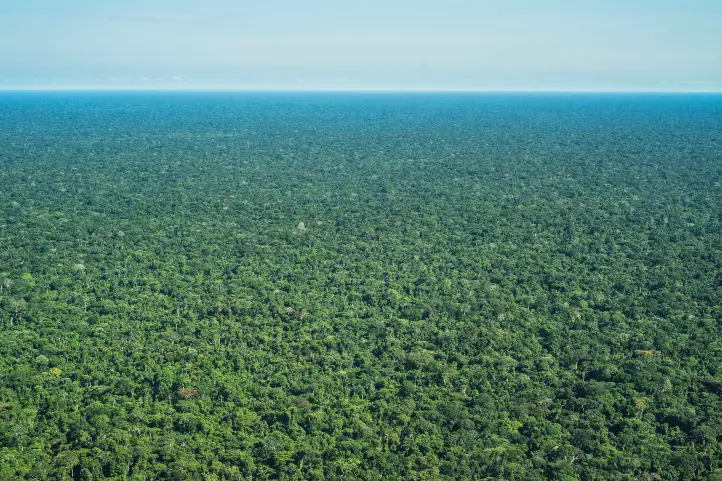
Guaviare is one of the least populated departments of Colombia, and one of the most pristine nature destinations in the country.  

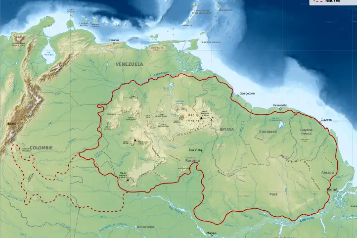
Additionally, this department is located in the Colombian Amazon region, although part of its territory is also in the Orinoquia. Its capital is San José del Guaviare. 

Brief history of Guaviare

In the past, the colonization of Guaviare was mainly due to the enormous natural riches of its soil and the exploitation derived from these.

People came there to cultivate balata and rubber. Moreover, trade of wild animal skins, native plants and ornamental fish was also common.

Finally, the illicit cultivation of coca attracted many people, bringing also war and chaos to the region.

Today, tourism is opening as a new possibility for the economic development of the region, and it works as a good strategy for the protection and conservation of natural and archaeological areas.

Weather and Landscape

The dry season happens from December to February, and the rainy season during the rest of the year (especially April-July and October-November). Annual rainfall ranges from 2,000 to 3,500 mm. The temperature during the day reaches 25° to 30 °C, dropping at night to 12 °C between July and August.

Its soils are bathed by numerous rivers and a network of streams, divided mainly into two basins: Orinoco River Basin and Amazon River Basin.

Tourism in Guaviare 

Tourism is making its way in this destination dedicated to adventure and sustainability. It is an opportunity for sustainable development in he region. The natural environments for swimming, the sunsets, and its ecosystems make it a unique destination.

Archaeological places, and the fauna and flora that make up an abundant biodiversity, are the greatest attraction of Guaviare.

The Most Featured Destinations in Guaviare 

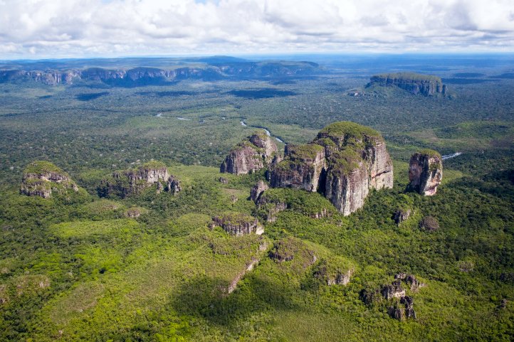
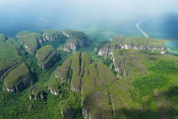
Serrania de La Lindosa and Cerro Azul

Serranía de la Lindosa @Parques Naturales

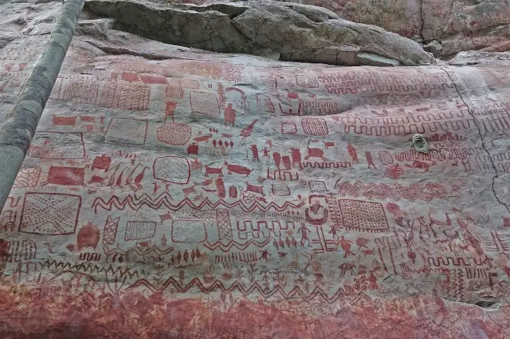
This place is one of the eight archaeological zones declared as a protected area by the Ministry of Culture of Colombia.

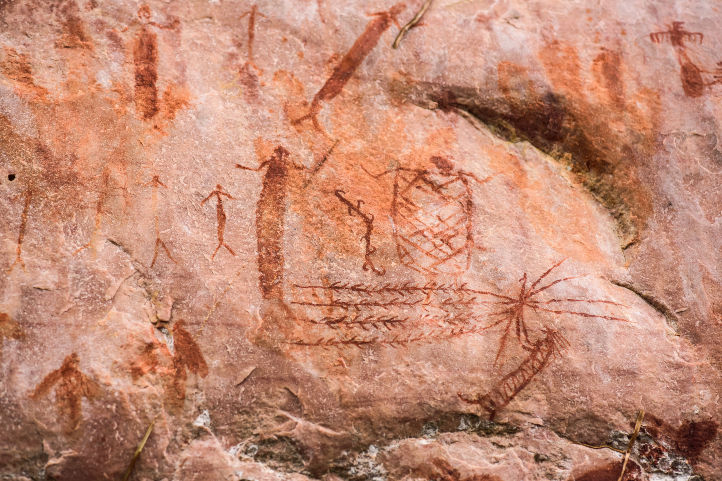
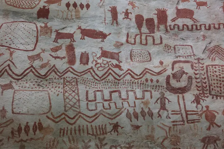
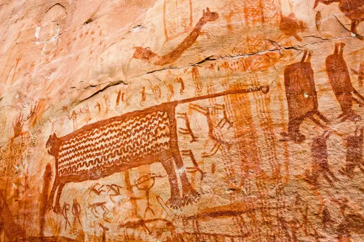
Here you will find the famous cave paintings, among others those of the Guayabero River and the Caño Dorado, with vivid colors. In the Cerro Azul in the Serranía La Lindosa, you can observe paintings that are twelve thousand years old.

The summit of Cerro Azul can be reached by a medium level hike of approximately 40 minutes. In Cerro Azul, there are a series of cave paintings painted with reddish pigment by indigenous people who inhabited the La Lindosa mountain range 7,250 years ago.

It is a two-hundred-meter-high peak to explore and walk. During the walk you can find giant trees and native species of flora and fauna. From the top you can see numerous streams of crystalline water and the jungle.

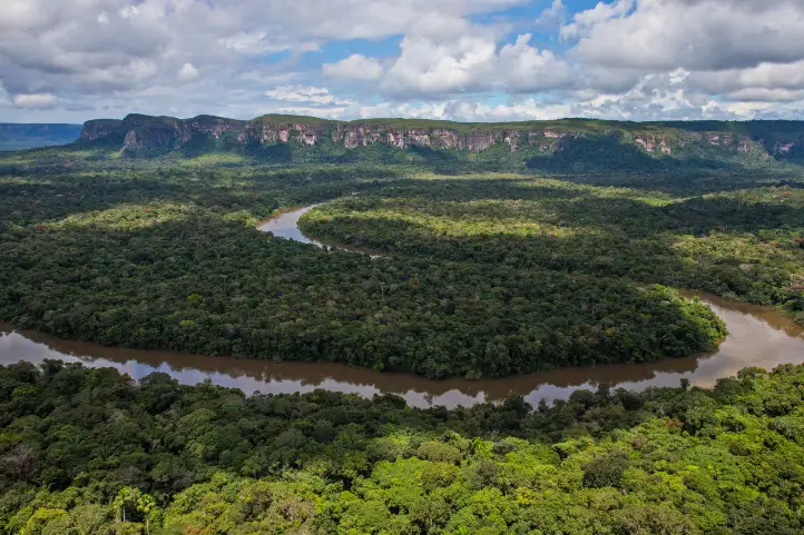
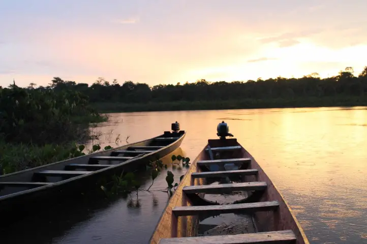
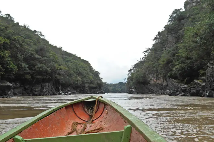
Raudal of the Guayabero

Raudal del Guayabero @ Juan Pablo Rozo – Wikiloc

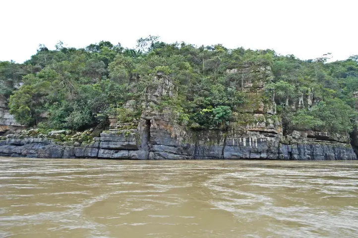
This spectacular spot is one hour by river, and one hour and thirty minutes by land, from San José del Guaviare.

The Guayabero River, before its encounter with the Ariari, is framed in a canyon formed by walls of rocks of Pre-Cambrian origin.

From there, a current is unleashed that reaches half a kilometer in length. Although it is navigable throughout the year, the summer season is the best time to cross it.

Throughout the tour you can see the gray freshwater dolphin or Tonina (Sotalia fluviatilis), as it is called by the inhabitants of the region.
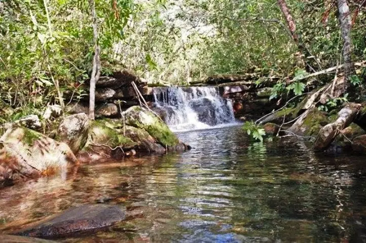
Natural Bridges

Rocky Bridges Pic. by Parques Nacionales

These natural bridges are high and have been shaped and polished by water over time. They stand on a ravine to which it is possible to descend with certified guides.

The City of Stone

Serranía de la Lindosa ©Parques Naturales

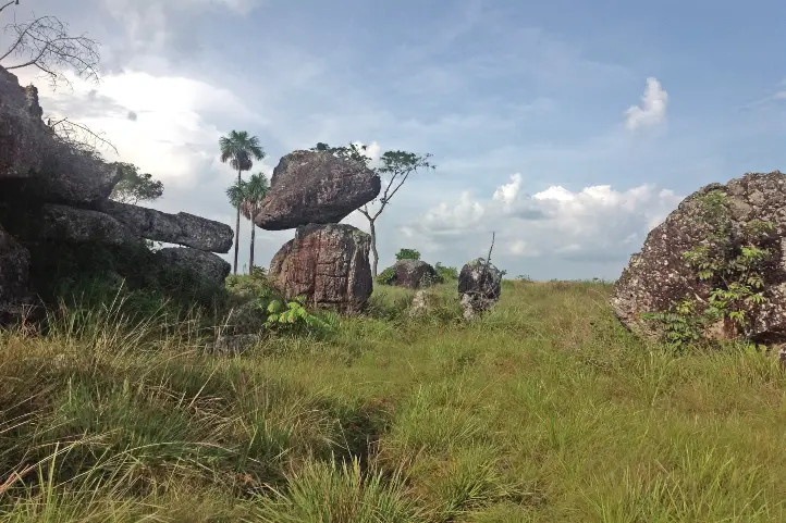
The Stone City of San Jose, is an enigmatic place that consists of ancestral rocks distributed with an impressive and mysterious symmetry.

In the company of guides, you can tour this site that has labyrinths, caves, and monoliths with very old petroglyphs. A special place for hiking and caving.

Natural Baths of Agua Bonita, Villa Luz and Tranquilandia.

Tranquilandia Bath

They are located only five miles from the city, in Caño Sabana. The ancient rock formations form pools of crystalline waters of different colors. The rich plant and mineral environment is the one that colors these waters, so it is very similar to the rainbow river in La Macarena. You can go there and enjoy a good swim and landscape.
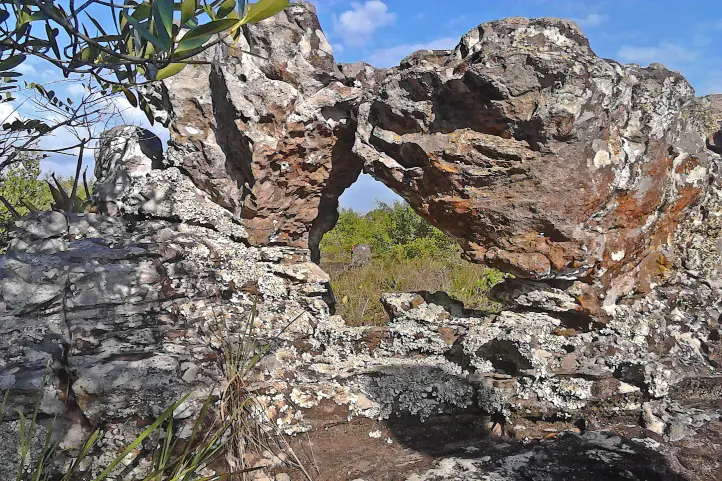
Puerta de Orión

Puerta de Orión Pic. by Parques Nacionales

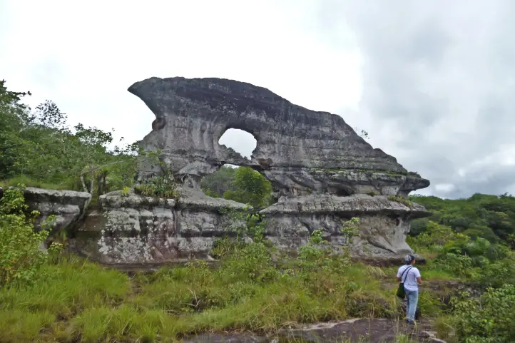
Orion’s Gate is a rock formation emblematic of the city, found 9 kilometers from San José del Guaviare. It is twelve meters high and 20 meters wide. It has two natural holes, one on top of the other.

To get to Puerta de Orión you must pass through cavities and cornices that make it an enigmatic scenery.

The particularity of this natural wonder is that in the summer solstice you can observe Orion’s Belt through the upper window, creating a unique spectacle.

Sport fishing and Kayaking at Laguna Negra 

Sunsent at Laguna Negra ©El Tiempo

Laguna Negra is located 11 kilometers from San José del Guaviare. The black color that the water projects is because at the bottom there are decomposed leaves from the surrounding forests.

Its name is due to the dark tone of its waters seen from the air. Once on land, you can see a scenario of crystalline water, according to experts, because of the thick vegetation that surrounds it.

This natural reserve, 11 km from San José del Guaviare, constitutes the ideal scenario for the practice of artisan fishing and snorkel. You can find “cachazas” and “payaras”.

Kayaking and sailing, among other practices, are part of the new offer.

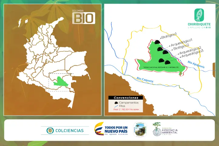
Chiribiquete National Park

Jaguar Petroglyph Chirbiquete ©Parques Nacionales Naturales

Because it is a complete planetary treasure, in 2018 it has been declared a mixed heritage of humanity.

It is located in the departments of Caquetá and Guaviare, and preserves the largest sample of rock art in the world.

In Chiribiquete there are approximately 70,000 paintings and 50 panels of an average height of 7 meters.

These have served to distinguish a cultural tradition of roots, apparently very old, of the Paleo-Indian. Therefore, they have been associated with groups of hunter-gatherers of the Tropical Rainforest and semi-dry enclaves of the Guianas and the Amazon.

Other Attractions

Guayabero Pic. by Juan Pablo Rozo – Wikiloc
  • Rural and community tourism: Finca Chontaduro, Finca Diamante, replacement of coca for fruit.
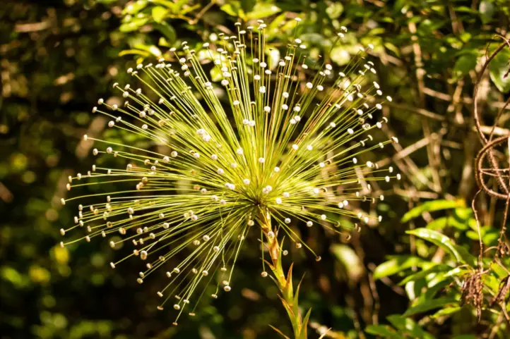
  • The “Flor del Guaviare” (Paepalanthus formosus Moldenke) is one of the emblems of the department.
Guaviare Flower, ©Gabriel Arroyo – iNaturalist
  • Thermal waters, unique in the Orinoco and Amazon;
  • The Inírida River;
  • The natural National Parks of Chiribiquete and Nukak; and
  • An endless number of lakes and lagoons where pink dolphins and fishing abound.
Nukak ©Nathaly Londoño – Parques Nacionales

How to get to Guaviare

The trip Bogotá – Guaviare by plane takes about 1.20 hour. The tourist sites are easily accessible by 4X4 vehicles. The capital, San José del Guaviare, has become a center of operation with a wide range of lodging facilities: three stars hotels, hostels, and camping.

Where to stay in San José del Guaviare

We recomend you the following hotels in San José del Guaviare:

  • Hotel Quinto Nivel
  • Hotel Aeropuerto

If you want to know more about the most incredible natural destinations in Colombia, plan your trip with us!


References

About the author

Sara Colmenares

Current director of Sula. Doctor in Biological Sciences. Her main interests are to explore and understand the organism – environment interactions, taking advantage of emerging knowledge for the management and conservation of species and ecosystem services. She is currently working as a consultant in functional ecology, ecosystem services and conservation projects in Colombia related to ecotourism and birdwatching.

Why Chiribiquete is called the Sistine Chapel of Colombia?


Serranía de Chiribiquete mountain range, and its surroundings, present a landscape in which strange forms rarely seen or even imagined stand out.

Together with the enormous extensions of virgin forest, it makes an illusory, magical and very old “lost world”, in the heart of the Colombian Amazon.

The Guiana Shield

The Guiana Shield is a geographic region located in the northeast of South America. It is a very old geological formation, being one of the oldest areas on Earth, from the Pre-Cambrian era.

Almost from the very moment of the formation of the planet Earth, some very high plateaus with vertical slopes, called tepuis, have originated in this place.

Tepuy is a term from the indigenous Pemón language, which means “mountain”.

Tepuis Chirbiquete ©Parques Nacionales Naturales

In the Guiana shield, you will find the famous Angel Falls, or Kerepakupai Meru, the highest waterfall in the world with 979 m. Also, the highest and most impressive tepui of all, Mount Roraima. Both in Venezuela.

The Guiana Shield of Colombia

The western part of the Guiana shield is located in the eastern zone of Colombia, covering the departments of Guainía, Vichada, Vaupés, Caquetá, and Meta.

Guiana shield MAP ©Free Art License

The Guiana Shield penetrates Colombia, across the border with Venezuela and Brazil, and possessess those characteristic rocky outcrops known as Tepuis.

Being so far away from the Andean system, deep in the Colombian Amazon, these outcrops of the Guiana Shield are little known, with some exceptions.

Serranía de Chirbiquete ©Parques Nacionales Naturales

Among the most famous tepuis are Cerros de Mavecure, in the department of Guainía, Sierra de La Macarena, place of the rainbow river, in Meta, Serranía de La Lindosa in Guaviare and the Iguaje tables, in Caquetá.

These mountains are a reduced scale version of the great mountains of the Guianas that culminate in the hills of La Neblina and Roraima in Venezuela.

Serrania del Chiribiquete

The Serrania del Chiribiquete is one of the oldest geological formations on the planet and is part of the Guiana Shield.

The mountain range of Chiribiquete was the territory of Paleoindian groups that left graphic testimony of the temporary occupation of some of its tepuis in many cave paintings.

Petroglyph Chirbiquete ©Parques Nacionales Naturales

According to the experts, Chiribiquete was used as a rocky shelter that served as a temporary refuge and also as a place of worship for centuries.

The Rupestrian Art of Chiribiquete

Chiribiquete is one of the most emblematic places of American rupestrian art.

In this place, there is a collection of murals with more than 75,000 cave paintings, where the jaguar is the protagonist. But this number only represents between 5% to 8% of all of the paintings there.

Jaguar Petroglyph Chirbiquete ©Parques Nacionales Naturales

The pictographs are supposed to be ancient writings that have maintained the existence of the ‘secret of the world’. For this reason, it has been called the Sistine Chapel of the Amazon. From there, the ancestral stories of some of the indigenous peoples of the region emerged.

Some studies point out that the human presence in the area of Chiribiquete possibly dates back to 15500 years BC.

According to more recent archaeological and chronological evidence, it has been specified that the age of the rupestrian art of Chiribiquete is around 22000 years, which makes it the oldest on the continent.

Serrania de Chiribiquete National Natural Park

Chiribiquete is also a place where the biological richness is almost intact. There are few places in the world with these conditions, these characteristics of insularity, endemism, fragility and biodiversity.

Chirbiquete ©Parques Nacionales Naturales

The Serrania de Chiribiquete National Natural Park was created in 1989. This park is a mega reserve that contributes to maintaining the physical and biotic components of one of the areas with the highest biological diversity on the planet.

Scientists refers to Chiribiquete as a place with a high degree of endemism, and there is the discovery of new species with every expedition that has been made.

Colombia BIO expedition in Chiribiquete Park – Map ©MinCiencias

The declaration of Chiribiquete as a World Heritage Site (by UNESCO) occurred in July 2018; at which time the Government of Colombia also expanded the park’s territory.

Thus, the park constitutes a mixed heritage of humanity, since it represents a great contribution to the preservation of biodiversity and natural ecosystems for the planet; as well as the multiplicity of cultural expressions of the communities that have settled through time in the territory.

Tourism in Chiribiquete

The demobilization of the FARC (Revolutionary Armed Forces of Colombia) in 2016 made one think about tourism.

Unfortunately, the human presence caused vandalism, and the park has also been threatened by mining and illegal logging.

Opening this place as a tourist destination would end up greatly altering the conditions of the place, because it requires infrastructure, services, and permanent transit of people.

Thus, in order to protect Chiribiquete’s archeological and natural treasure, it is closed to the public. And you can only fly over it.

Overflights in the Serranía de Chiribiquete NNP

The aircraft will take off and land at the Jorge Enrique González Airport in the city of San José del Guaviare.

The overflights will take place in a single corridor defined and approved by National Parks, and there is a maximum time of three hours per overflight.

Chirbiquete Aerial View ©Parques Nacionales Naturales – Julia Miranda

The season, duration, and route of the overflights were designed to guarantee the protection of the ecosystems, and of the indigenous peoples in voluntary isolation who inhabit the area.

Where to stay in Chiribiquete NNP

Staying in Chiribiquete NNP is not allowed. However, since flights take off from San José del Guaviare, you can think about staying there. This way, you will have the opportunity to appreciate the natural and cultural richness of the Serranía la Lindosa.

Serranía La Lindosa

The Serrania La Lindosa is located 1.5 hours from San José del Guaviare. It is one of the places with more cave paintings in the world, and has been declared a Protected Archaeological Area of Colombia by the Colombian Institute of Anthropology and History, ICANH.

Cave paintings of the Nukak, Serranía de La Lindosa. ©Julian Ruiz P. CC

This place is open for ecotourism, being the ideal space for you, before or after your flight, to get close to what you can find in the Serrania de Chiribiquete National Natural Park.

Best time to visit Chiribiquete NNP

Only two overflights are allowed per week and during January, Easter, June, July, October and December.

Chiribiquete NNP Entrance fees

Overflights might vary according to the season, availability, tour operator and the number of travelers. However, an overflight may cost around 1450 USD.

 If you are planning a trip to Colombia, we are happy to help you have an unforgettable nature experience! Contact us


References
About the author

Sara Colmenares
Current director of Sula. Doctor in Biological Sciences. Her main interests are to explore and understand the organism – environment interactions, taking advantage of emerging knowledge for the management and conservation of species and ecosystem services. She is currently working as a consultant in functional ecology, ecosystem services and conservation projects in Colombia related to ecotourism and birdwatching.