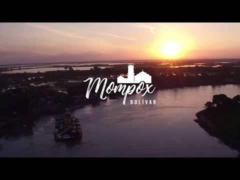
Travel Guide to Santa Cruz de Mompox, Mompós or the Land of God

Mompox is one of the most beautiful heritage towns in Colombia and has one of the best-preserved historic centers in Latin America. Santa Cruz de Mompox or Mompós has the typical architecture of the Spanish Colony, with white facades and beautiful windows covered with wrought iron railings.

This architectural beauty, as well as its excel of conservation, led Mompox to be declared a National Monument in 1959 and a World Heritage Site by UNESCO in 1995.

When this town was built in 1540 it was an important port. With time it became isolated, and that allowed it to preserve its architectural heritage. It is the magical place that so often inspired our Colombian Nobel Prize winner Gabriel García Márquez.

It is also known as the first town of the Viceroyalty of the New Kingdom of Granada to give the cry of absolute Independence from Spain.

Santa Cruz de Mompox, the largest river island in Latin America, also holds in its streets a unique cultural treasure in Colombia. The Mompox Jazz Festival launched in 2012, enhanced the tourist vocation of the town, attracting travelers from around the world.

Below you will receive the necessary information you need to make the most of your visit to Santa Cruz de Mompox.

Exploring Santa Cruz de Mompox

Momopox is located in the department of Bolivar, 320 km from Cartagena by land. It is on the list of “Network of Colombian Heritage Towns” a place full of history and culture. Its name comes from the indigenous Malibu language, “Mompoj”, and since the XVIII century it is called Mompox or Mompós in the official documents of the country; it is also known as “La Tierra de Dios” i.e. The Land of God.

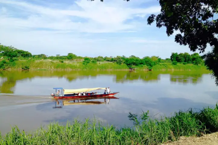
It is located in the Department of Bolivar, 248 kilometers from Cartagena, and is bordered by the municipalities of Magangué (Bolivar), Pinillos and San Fernando (Bolivar), Santa Ana, San Zeno, and San Sebastian de Buenavista (Magdalena), with the Magdalena River in between, and with the municipality of Talaigua Nuevo (Bolívar).

The average temperature in Santa Cruz de Mompox is between 23 ºC (73ºF) to 38 ºC (100 ºF) and the best time of the year to visit Mompós is from mid-December to the end of February.

How to get to Santa Cruz de Mompox

You can take a direct flight from El Dorado (BOG) in Bogotá to San Bernardo Airport (MMP) at Santa Cruz de Mompox with a duration of 1,5 – hours.

Other alternatives to get to Mompox are:

  • Bogotá – Cartagena – Mompox

Take a 1,5-hours flight from El Dorado (BOG) in Bogotá to Rafael Nuñez International Airport (CTG) at Cartagena city. Once at in Cartagena you take an approximately 5,5-hours ride (273 Km) to Santa Cruz de Mompox

  • Bogotá – Sincelejo – Mompox

Take a 1,5-hours flight from El Dorado (BOG) in Bogotá to Las Brujas Airport (CZU) at Sincelejo city. Once in Sincelejo, you take an approximately 3-hours ride (148 Km) to Santa Cruz de Mompox.

Where to stay in Santa Cruz de Mompox

Bioma Hotel Boutique, Mompox, Bolívar, Colombia CC Bioma

In Mompox you can find several lodging options, among those are hotels that preserve the local architecture, we recommend:

Santa Cruz de Mompox Attractions and Activities

Historical and Cultural Activities in Mompox

In “La Tierra de Dios”, you will be able to appreciate the Andalusian architecture of the XVI century, considered one of the most precious cultural and historical jewels of the Caribbean.

The Culture House

It has civil architecture. It has been in operation since 1962, and keeps, as its director shows us, elements of the historical archive, antiques, works of Candelario Obeso, the black poet, and one of the maximum referents of the momposina culture, homemade swords, elements of tailoring of the time and indigenous crafts, among others.

Te Deum House

Its name comes from the Latin inscription that its owner Don Pedro Martinez de Pinillos placed on its façade: “Té Deum Lauda mus Te Dominum”. Renowned for its gardens and the huge sun tree in the middle of the courtyard, refuge of the howler monkeys, a species that moves around the city and emits a particular sound.

House of the Portals o the Marquesa de Torrehoyos

It is a group of houses (four) that is undoubtedly a permanent attraction in the city, is clearly distinguished by the portals or external gallery that runs along its facade and that prints an architectural character of its own and very different from the homogeneous silhouette of the city.

Rosario Cemetery Mompox, Bolivar, Colombia . Alcaldia Mompox, CC BY-SA 4.0

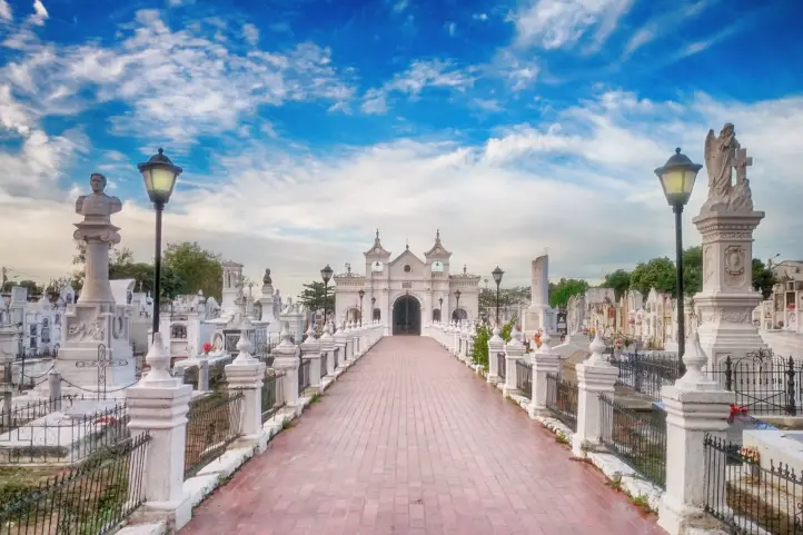
Mompox Rosario Cemetery

Usually, cemeteries are not tourist places but the cemetery of Mompox, along with that of Barichara, are among the most beautiful in Colombia.

A space full of cultural and historical heritage, besides having beautiful burial constructions and is inhabited by many cats. During the Holy Week season, it becomes the scene of the traditional serenade to the deceased.

San Anselmo Fort

Possibly it was built as a simple warehouse or deposit of merchandise. It is owned by an Austrian who, after sailing around the world in his sailboat, arrived and stayed in Mompox. At the next table, there are four old men, who with a slow coastal accent greet us, while they evoke, in a pleasant gathering, an epic Santa Cruz de Mompox.

Church of Santa Bárbara

It has a balcony that is undoubtedly the most impressive element. It is located in the square of Mompox, and it is also the place of legends among the locals.

Immaculate Conception Church

Built-in 1541 and despite having been rebuilt several times. In the interior you can notice several aspects, among others, the way the central nave was covered, using for it the armor of pair and knuckle.

Santo Domingo Church

It was built as a straw temple by the friars of the Dominican order, the first to preach the gospel in America. Years later its roofs were covered with bricks that remained useful until August 19, 1846, when it collapsed. Ten years later in 1856, the temple was restored.

San Francisco Church and Convent

This beautiful church is a clear example of momposina elegance, its walls are covered in red ochre in contrast with its white lines. A cultural jewel, worthy of knowing and appreciating.

San Juan de Dios Church

Built-in the XVII century. The church officiates on Holy Thursday, the mass for the sick and disabled to participate in the Momposina Holy Week.

Natural Attractions in Mompox

Mompos, Bolivar, Colombia. A town surrounded by swamps and rivers.

Pijiño Swamp

It is a backwater where different species of birds coexist, approximately 20, it is possible to find the white heron, the brown heron, the little brown heron, and also the kingfisher; in addition to the presence of reptiles.

This marsh has an area of approximately 1,350 hectares. Bird watching excursions are part of a program to show the world the richness of Colombia’s biodiversity and are promoted by the National Tourism Fund (Fontur) and the Ministry of Commerce, Industry and Tourism.

Margarita Island

This island is located in the geographical situation called the Momposina depression, bathed by the waters of the Magdalena River, with the arms of Loba, Mompox, and Chicagua; and has an area of 2600 square kilometers.

The island is home to fish species such as barbudo, bocachico, mojarra amarilla and mojarra lora, and amphibians such as babillas, galapagos, turtles and otters. The flora is composed of cantagallo, mangrove, bell pepper, coquillo or cocuelo and campano.

If you want to come to Colombia contact us and plan your trip with us.

References
About the Authors

Luisa Martin

Engineer, world traveler, amateur photographer, traveling blogger, and foody.

Why Chiribiquete is called the Sistine Chapel of Colombia?


Serranía de Chiribiquete mountain range, and its surroundings, present a landscape in which strange forms rarely seen or even imagined stand out.

Together with the enormous extensions of virgin forest, it makes an illusory, magical and very old “lost world”, in the heart of the Colombian Amazon.

The Guiana Shield

The Guiana Shield is a geographic region located in the northeast of South America. It is a very old geological formation, being one of the oldest areas on Earth, from the Pre-Cambrian era.

Almost from the very moment of the formation of the planet Earth, some very high plateaus with vertical slopes, called tepuis, have originated in this place.

Tepuy is a term from the indigenous Pemón language, which means “mountain”.

Tepuis Chirbiquete ©Parques Nacionales Naturales

In the Guiana shield, you will find the famous Angel Falls, or Kerepakupai Meru, the highest waterfall in the world with 979 m. Also, the highest and most impressive tepui of all, Mount Roraima. Both in Venezuela.

The Guiana Shield of Colombia

The western part of the Guiana shield is located in the eastern zone of Colombia, covering the departments of Guainía, Vichada, Vaupés, Caquetá, and Meta.

Guiana shield MAP ©Free Art License

The Guiana Shield penetrates Colombia, across the border with Venezuela and Brazil, and possessess those characteristic rocky outcrops known as Tepuis.

Being so far away from the Andean system, deep in the Colombian Amazon, these outcrops of the Guiana Shield are little known, with some exceptions.

Serranía de Chirbiquete ©Parques Nacionales Naturales

Among the most famous tepuis are Cerros de Mavecure, in the department of Guainía, Sierra de La Macarena, place of the rainbow river, in Meta, Serranía de La Lindosa in Guaviare and the Iguaje tables, in Caquetá.

These mountains are a reduced scale version of the great mountains of the Guianas that culminate in the hills of La Neblina and Roraima in Venezuela.

Serrania del Chiribiquete

The Serrania del Chiribiquete is one of the oldest geological formations on the planet and is part of the Guiana Shield.

The mountain range of Chiribiquete was the territory of Paleoindian groups that left graphic testimony of the temporary occupation of some of its tepuis in many cave paintings.

Petroglyph Chirbiquete ©Parques Nacionales Naturales

According to the experts, Chiribiquete was used as a rocky shelter that served as a temporary refuge and also as a place of worship for centuries.

The Rupestrian Art of Chiribiquete

Chiribiquete is one of the most emblematic places of American rupestrian art.

In this place, there is a collection of murals with more than 75,000 cave paintings, where the jaguar is the protagonist. But this number only represents between 5% to 8% of all of the paintings there.

Jaguar Petroglyph Chirbiquete ©Parques Nacionales Naturales

The pictographs are supposed to be ancient writings that have maintained the existence of the ‘secret of the world’. For this reason, it has been called the Sistine Chapel of the Amazon. From there, the ancestral stories of some of the indigenous peoples of the region emerged.

Some studies point out that the human presence in the area of Chiribiquete possibly dates back to 15500 years BC.

According to more recent archaeological and chronological evidence, it has been specified that the age of the rupestrian art of Chiribiquete is around 22000 years, which makes it the oldest on the continent.

Serrania de Chiribiquete National Natural Park

Chiribiquete is also a place where the biological richness is almost intact. There are few places in the world with these conditions, these characteristics of insularity, endemism, fragility and biodiversity.

Chirbiquete ©Parques Nacionales Naturales

The Serrania de Chiribiquete National Natural Park was created in 1989. This park is a mega reserve that contributes to maintaining the physical and biotic components of one of the areas with the highest biological diversity on the planet.

Scientists refers to Chiribiquete as a place with a high degree of endemism, and there is the discovery of new species with every expedition that has been made.

Colombia BIO expedition in Chiribiquete Park – Map ©MinCiencias

The declaration of Chiribiquete as a World Heritage Site (by UNESCO) occurred in July 2018; at which time the Government of Colombia also expanded the park’s territory.

Thus, the park constitutes a mixed heritage of humanity, since it represents a great contribution to the preservation of biodiversity and natural ecosystems for the planet; as well as the multiplicity of cultural expressions of the communities that have settled through time in the territory.

Tourism in Chiribiquete

The demobilization of the FARC (Revolutionary Armed Forces of Colombia) in 2016 made one think about tourism.

Unfortunately, the human presence caused vandalism, and the park has also been threatened by mining and illegal logging.

Opening this place as a tourist destination would end up greatly altering the conditions of the place, because it requires infrastructure, services, and permanent transit of people.

Thus, in order to protect Chiribiquete’s archeological and natural treasure, it is closed to the public. And you can only fly over it.

Overflights in the Serranía de Chiribiquete NNP

The aircraft will take off and land at the Jorge Enrique González Airport in the city of San José del Guaviare.

The overflights will take place in a single corridor defined and approved by National Parks, and there is a maximum time of three hours per overflight.

Chirbiquete Aerial View ©Parques Nacionales Naturales – Julia Miranda

The season, duration, and route of the overflights were designed to guarantee the protection of the ecosystems, and of the indigenous peoples in voluntary isolation who inhabit the area.

Where to stay in Chiribiquete NNP

Staying in Chiribiquete NNP is not allowed. However, since flights take off from San José del Guaviare, you can think about staying there. This way, you will have the opportunity to appreciate the natural and cultural richness of the Serranía la Lindosa.

Serranía La Lindosa

The Serrania La Lindosa is located 1.5 hours from San José del Guaviare. It is one of the places with more cave paintings in the world, and has been declared a Protected Archaeological Area of Colombia by the Colombian Institute of Anthropology and History, ICANH.

Cave paintings of the Nukak, Serranía de La Lindosa. ©Julian Ruiz P. CC

This place is open for ecotourism, being the ideal space for you, before or after your flight, to get close to what you can find in the Serrania de Chiribiquete National Natural Park.

Best time to visit Chiribiquete NNP

Only two overflights are allowed per week and during January, Easter, June, July, October and December.

Chiribiquete NNP Entrance fees

Overflights might vary according to the season, availability, tour operator and the number of travelers. However, an overflight may cost around 1450 USD.

 If you are planning a trip to Colombia, we are happy to help you have an unforgettable nature experience! Contact us


References
About the author

Sara Colmenares
Current director of Sula. Doctor in Biological Sciences. Her main interests are to explore and understand the organism – environment interactions, taking advantage of emerging knowledge for the management and conservation of species and ecosystem services. She is currently working as a consultant in functional ecology, ecosystem services and conservation projects in Colombia related to ecotourism and birdwatching.

Next Travel Ideas? Visit the Biosphere Reserves of Colombia

Did you know that Colombia has as many as 5 biosphere reserves? Biosphere Reserves are terrestrial and marine ecosystems protected by the Countries and by the World Network of Biospheres, whose main function is the conservation of the planet’s biodiversity and sustainable use.

The Biosphere Reserves are internationally recognized within the framework of the United Nations Education, Scientific, and Cultural Organization’s (UNESCO) Man and Biosphere Program (MAB).

The Biosphere Reserves form a Global Network in which each country participates on a voluntary basis. Additionally, UNESCO has defined operational guidelines for Biosphere Reserves as a way to ensure better international cooperation. This also takes into account national laws, which play an important role in the status of a biosphere reserve.

But What are Exactly the Biosphere Reserves?

The biosphere reserves are the central instrument of the Man and Biosphere Program (MAB) of the United Nations Educational, Scientific and Cultural Organization (UNESCO), which was established in 1976 to promote sustainable regional development.

Biosphere reserves are extensive and representative areas of natural and cultural landscape, which must be safeguarded in the long term.

Moreover, biosphere reserves must achieve the three fundamental objectives of conservation, development, and logistics as follows:

  • From conservation, the reserve must ensure the genetic heritage and the refuge of natural and cultural landscapes. In turn, it must safeguard ecosystem services (i.e. clean water, clean air, food, recreation).
  • From development, it aims to apply sustainable ecological and socioeconomic techniques in all economic sectors.
  • From logistics, it must facilitate multidisciplinary research and educational activities.

They represent a reservoir of genetic resources and ecosystems and are also areas of sustainable land use, spaces for education, research, and recreation. The biosphere reserves are like “laboratories” where the flora and fauna found in this area are subjects of natural and scientific interest. Additionally, the integrated management of land, water, and biodiversity is studied at these reserves.

The Biosphere Reserves of Colombia

Colombia’s location towards the north of South American region is naturally surrounded by open water from two sides, from the Caribbean Sea and the Pacific Ocean. It also counts with important ecosystems such as the Biogeographic Chocó, the Andean Mountain range, the Eastern plains of Orinoquía, and the Amazon jungle, among the biggest ones.

This privileged biogeographic position of Colombia provides an ideal habitat for a diverse range of flora and fauna to flourish, and that is why it has 5 biosphere reserves that protect important and unique ecosystems existing in the Colombian territory.

Colombia’s Biosphere Reserves Map modified from Google Maps

Needless to say, these reserves surely deserve a visit. Check out this list of the 5 biosphere reserves of Colombia:

The Andean Belt Biosphere Reserve, declared by UNESCO in 1979

Location

The Andean Belt Biosphere Reserve is located in the Colombian massif in the south of the Andes. The Andean belt includes three national parks: La Cueva de los Guacharos Natural National Park, Puracé Natural National Park, and Nevado del Huila Natural National Park.

Highlights

Cueva de los Guacharos Natural National Park

Cueva de los Guácharos NNP was the first area in Colombia to be declared a national park in 1960.

The Cueva de los Guácharos park protects the Andean forest and paramos, from 1200 to 3800 masl. What stands out most is the protection of the extensive and almost extinct areas of Andean oak (Quercus humboldtii Bonpl., Fagaceae) and the endemic oak Colombobalanus excelsa Lozano, Fagaceae, a new species of oak described in the park in 1979.

Cueva de los Guácharos ©Parques Nacionales Archive

The park owes its name to the guácharo bird (Steatornis caripensis, order Caprimulgiformes, family Steatornithidae). This is a frugivorous, nocturnal bird that lives in caves and hollows. Its name is onomatopoeic, it is derived from the Quechua huach and means to scream or cry, because of its characteristic song. Something very interesting about these birds is that, like bats, they are guided by a system of echolocation.

Puracé Natural National Park

Puracé National Natural Park is a volcanic zone and protects high mountain ecosystems, as well as nationally threatened species such as the Colombian pine (Podocarpus oleifolius), the oak (Quercus humboldtii), the wax palm (Ceroxylon spp), and the tree fern (Cyathea spp), and animals such as the Andean Condor.

Andean Condor

Its name, in the Quechua language, means “mountain of fire”. The main rivers of Colombia are born there: Magdalena, Cauca, Patía and Caquetá and also 30 calm and clear lagoons, ideal for contemplation.

Within its marvelous landscape, the Coconucos volcanic chain rises, also known as the Serrania de los Coconucos, composed of 11 volcanoes. Of these, the most outstanding are the Sugar Loaf (5,000 meters / 16,404 feet above sea level), the Puracé (4,780 meters / 15,682 feet  above sea level) that is the only active one, and the Coconuco (4,600 meters / 15,091 feet above sea level).

Nevado del Huila Natural National Park

This snow-capped mountain has the largest glacier in the central mountain range of the Colombian Andes and is the second largest glacier in the country, after Cocuy.

Huila snow-capped mountain ©Parques Nacionales Archive

The park shelters a volcanic area with paramo, subpáramo, and Andean forest vegetation. It also overlaps with indigenous reserves in the departments of Tolima and Cauca. This park is closed to tourists.

Tourist Activities

  • Birdwatching (take a look on our trip Upper Magdalena Birdwatching Tour).
  • Trekking.
  • Botanic and scientific tours.
  • Community-based tourism.
  • Cultural Heritage Observation.

El Tuparro Biosphere Reserve, declared by UNESCO in 1979

Location

El Tuparro Biosphere Reserve is located in the eastern part of Colombia in the region of Orinoco in the Vichada department. The reserve is surrounded by the Tomo River to the north and the Caño Maipurés to the south. It is one of the few places in the world where the Amazon pink dolphin lives.

The Eighth Wonder of the World: Tuparro Natural Park ©CommonsWikimedia

Highlights

The park has numerous trails for bird watching and hiking. In the year 1800, standing in front of the imposing torrent that the natives called Quituna, in awe, the naturalist Alexander von Humboldt, described as the “Eighth Wonder of the World” what is known today as the Raudal de Maypures, one of the main attractions of the protected area.

Tourist Activities

  • Birdwatching.
  • Trekking.
  • Note: It is prohibited to visit the park for sportfishing. Don’t be fooled by unscrupulous offers.

The Sierra Nevada de Santa Marta Biosphere Reserve, declared by UNESCO in 1979

The mountainous system called the Sierra Nevada de Santa Marta is conceived as the ‘Ancestral Territory’ of the original peoples Iku (Arhuaco), Kággaba (Kogui), Wiwa and Kankuamo.

The Sierra Nevada de Santa Marta Biosphere Reserve is a pyramidal territory, isolated from the Andes, and considered the highest coastal mountain in the world. It is located to only 42 kilometers from the sea, and it rises abruptly from the coasts of the Caribbean Sea until reaching a height of 5,775 meters (18,946 feet) in its snowy peaks Bolívar and Columbus.

Sierra Nevada de Santa Marta

Location

To the north it is bordered by the Caribbean Sea and the plains of the Guajira peninsula; to the southeast it is framed by the courses of the Ranchería and Cesar rivers, and to the west, it borders the great alluvial plain of the Magdalena river and the Ciénaga Grande de Santa Marta.

Highlights

For the variety of ecosystems, thermal floors next to the sea, its singular beauty and cultural richness constitute it a unique territory. Its main attraction is a sacred site for the four indigenous peoples of the Sierra, this is the Teyuna Archaeological Park “Lost City”.

Tourist Activities

  • Hiking and Trekking at Teyuna Archaeological Park “Lost City”. For more tourist information about Tayrona Park and “Lost City treks” check our entries Best Time to Visit Tayrona Park to Avoid Crowds and Bad Weather and Travel Guide to The Lost City Trek – Ciudad Perdida – in Colombia.  
  • Birdwatching in Minca and surrounds. If you are looking for birdwatching tourist information in Sierra Nevada de Santa Marta visit our post: Colombia’s Prime Birding Destination: Sierra Nevada de Santa Marta.
  • Note: Natural National Parks of Colombia and the four indigenous groups of the Sierra Nevada de Santa Marta: Kogui, Arhuaco, Wiwa, and Kakuamo remind us that in the high parts of the Sierra Nevada de Santa Marta, including the lagoons, the páramos and the snow-capped mountains, tourism activities are NOT allowed due to the fragility of these ecosystems and the cultural importance. Entering these sectors constitutes an environmental infraction, according to the provisions of Decree 622 of 1977 – included in Decree 1076 of 2015

Ciénaga Grande de Santa Marta Biosphere Reserve, declared by UNESCO in 2000

The Ciénaga Grande de Santa Marta Flora and Fauna Sanctuary, together with the Salamanca Island Parkway – VIPIS, constitute the Nucleus Zones of the UNESCO-declared Biosphere Reserve and Ramsar Wetland of the Ciénaga Grande de Santa Marta Deltaic Complex.

Both recognitions highlights the importance for conservation of the Ciénaga Grande de Santa Marta at a national and international level. Know more about Ramsar Areas of Colombia in our entry Wetland Destinations in Colombia: Ramsar Areas of Colombia.

Ciénaga Grande de Santa Marta seen from Minca, Sierra Nevada de Santa Marta

Location

This Ciénaga Grande de Santa Marta Biosphere Reserve is located in the Caribbean region of Colombia, in the Department of Magdalena. It covers the municipalities of Ciénaga, Pueblo Viejo, Sitio Nuevo, Remolino, Salamina, El Piñón, Cerro de San Antonio, Concordia, Pivijay, El Retén, and Aracataca.

Highlights

The Ciénaga Grande de Santa Marta Flora and Fauna Sanctuary is formed by progressive accumulations of sediments from the Magdalena River. In turn, it is made up of mangrove ecosystems, swamps, rivers, canals, and marshy areas. It is part of a water complex of more than 100 swamps that present different levels of sedimentation and salinity.

Tourist Activities

  • Birdwatching.
  • Community-based tourism.
  • Note: It is not recommended to camp, nor to spend the night nearby because of the mosquitoes. There is also no place to stay. It is recommended to visit during the day, and stay in Barranquilla or Santa Marta.

Seaflower Biosphere Reserve, declared by UNESCO in 2000

The Seaflower Biosphere Reserve has become one of the most representative icons of marine protection in Colombia.

Conserving this set of ecosystems in the San Andres Archipelago is important for food security. Its economic valuation, because of the environmental services it provides, is estimated at more than $267 billion a year.

Seaflower Meaningful Diving – Natural Wealth Award

Location

This reserve is located in the department of San Andrés, Providencia and Santa Catalina Archipelago.

Highlights

Seaflower is the largest Biosphere Reserve in the world with 180,000 square kilometers. It has all the marine and coastal ecosystems representative of the tropical zone: coral reefs, mangroves, reef lagoons, sea grasses, wetlands, beaches, open sea, and tropical dry forest.

Seaflower Facts

  • 78% of the Colombian coral areas are in Seaflower.
  • It has the third-largest barrier reef in the world.
  • It has 57 species of coral, of which 90% are on the Red List of threatened species of the International Union for the Conservation of Nature (UICN).
  • Also, Seaflower has 407 species of fish, of the 600 estimated to exist in the Caribbean, and is home to 157 species of birds, of which 55% are threatened.
  • Its white beaches, attractive for tourism, owe their beauty to the calcareous contributions of coral.
  • It is estimated that its waters annually produce about 156 tons of lobster and 182 tons of fish through traditional fishing.

Old Providence McBean Lagoon National Natural Park

The Old Providence McBean Lagoon National Natural Park is the only nationally protected area in the Oceanic Caribbean of Colombia. It was declared a protected area in 1995, and became part of the “Seaflower” Biosphere Reserve in 2000.

Old Providence McBean Lagoon is formed by a small hill known as Iron Wood Hill, and the McBean Mangrove. In its marine portion, the Barrier Reef stands out, protecting the coasts of Providence Island, which is the second largest in the Caribbean with 32 km in length, after Belize.

This great coral reef, together with the reef lagoon that forms in front of the McBean mangrove, gives the sea a spectacular range of colors that go from deep blue to a translucent aquamarine green. It is thanks to this unique coloring that the Sea of Providence is known as “The Sea of Seven Colors”.

Tourist Activities

If you want to know more about the most incredible natural destinations in Colombia, plan your trip with us!


References


About the author

Sara Colmenares

Current director of Sula. Doctor in Biological Sciences. Her main interests are to explore and understand the organism – environment interactions, taking advantage of emerging knowledge for the management and conservation of species and ecosystem services. She is currently working as a consultant in functional ecology, ecosystem services and conservation projects in Colombia related to ecotourism and birdwatching.