Travel Guide to El Rosario and San Bernardo Corals National Natural Park

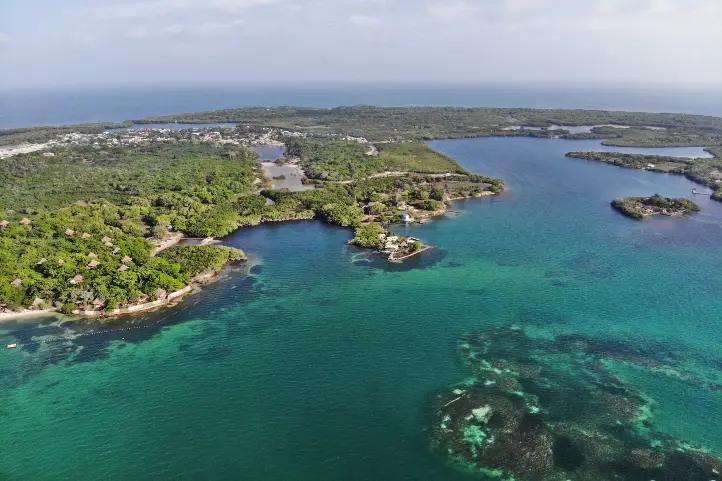
Meet the most iconic marine life paradise in Colombia, the El Rosario, and San Bernardo Corals National Natural Park. On the Caribbean coast of Colombia close to the coastal areas of the provinces of Bolívar and Sucre, and part of the jurisdiction of Cartagena, you will find the archipelago of El Rosario and San Bernardo Corals National Natural Park.

This archipelago is formed by 40 small islands, and it was declared a National Natural Park to protect the population of coral reefs and mangroves that are found in this area.

The crystal-clear waters and white beaches welcome those who visit the park to experience a large variety of flora and fauna. At the Rosario and San Bernardo islands, water activities such as canoeing, snorkeling, and diving are all must-do activities.

Discovering El Rosario and San Bernardo Corals National Natural Park

With an area of 1,200 square kilometers, the park has an underwater set of ecosystems that give life to the largest coral platform in the Colombian Caribbean. Thus, the park is host to the largest coral reef formations in Colombia. The three ecosystems you can find in the park are:
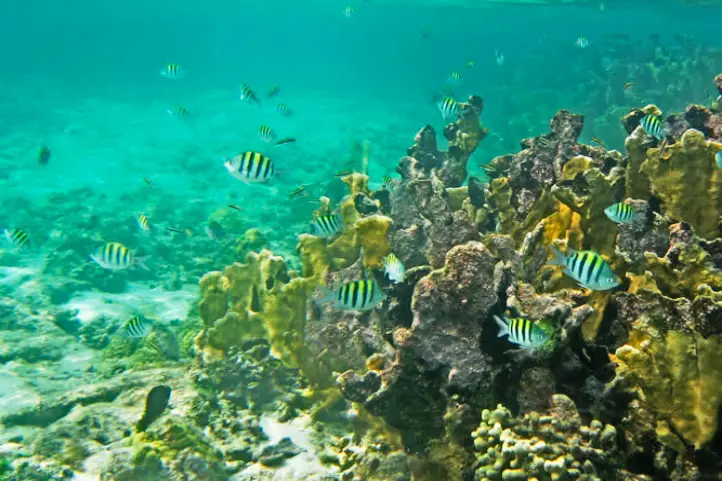
Coral reefs

These are the essential ecosystem that provides food and shelter for approximately 25% of the marine fauna present in the area.

Coral reefs, as in the rest of the world, are very vulnerable and need crystal waters, light, and stable substrates that do not affect their composition. The ideal temperature should be between 25º C (77º F) and 31º C (86ºF).

At San Bernardo, they take an area of 191.68 square kilometers, approximately 72% of the total amount of coral reefs in Colombia.

Mangroves

This marine-coastal ecosystem, formed by trees of different sizes with roots that protrude from the mud, is a powerful filter of salty water. Mangroves are by far the most productive ecosystem in these areas and an important source of flora and fauna resources.

More than 60% of the world’s tropical fish depend on this ecosystem for their survival. The park has four species of mangrove worth preserving:

  • Red mangrove (Rhizophora mangle),
  • White mangrove (Laguncularia racemosa),
  • Buttonwood or button mangrove (Conocarpus erectus); and
  • Black mangrove (Avicennia germinans).

Coral reefs and mangroves are also a powerful natural barrier to tsunamis and hurricanes.

Seagrass

The park has 30.35 square kilometers of sea pastures, serving as a food provider and shelter for several marine species.

Pastures depend on calm waters between 20 and 30 meters deep for their survival. This allows the circulation of nutrients that benefit them as well as the species that depend on them.

In the park, the most common seagrass species is the Turtle grass (Thalassia testudinum), providing firmness to the bottom of the ground where they live.

How to get to El Rosario and San Bernardo Corals National Natural Park

From Cartagena

When you arrive at Rafael Nuñez International Airport (CTG) take approximately 15 minutes to ride to the “La Bodeguita” dock (8 km). In “La Bodeguita” is necessary to take a boat trip of 2 hours to reach the facilities of the park in the archipelago of Our Lady of the Rosary (Nuestra Senora del Rosario).

From Santiago de Tolú

Take a 50 minutes flight from Bogotá to Las Brujas Airport (CTG) at Sincelejo city. From Sincelejo take an approximately 45 minutes ride to Santiago de Tolú (40 km).

Once at Santiago de Tolú is necessary to take a 1-hour boat trip to reach the facilities of the park in the archipelago of San Bernardo.

What to do in El Rosario and San Bernardo Corals National Natural Park

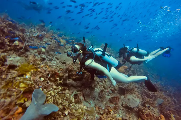
Diving and snorkeling

The underwater trails of Punta Brava and Luis Guerra in Isla Grande and Isla Tintipan are perfect for sea diving or snorkeling. A supervised company by authorized instructors is highly recommended.

We recommend staying within delimited marked areas.

Diving tours in the Rosario Islands, Cartagena ©https://divingplanet.org/

Sailing in the mangroves

The natural aquatic-terrestrial path of Isla Grande, the Lagoon of Silence, an ideal place to take photos and videos.

Help support Cangrejos Azules, the entity in charge of organizing ecotourism in the area with the help of local communities at Islas del Rosario.

Wildlife Observation

In the protected area it is possible to see 62 species of corals, including the blade fire coral (Millepora complanata), the thin leaf lettuce coral (Agaricia tenuifolia), and the massive starlet coral or round starlet coral (Siderastrea siderea).

In the case of decapod crustaceans, there are 153 species; mollusks with 244 species. No less than 153 species of echinoderms; 199 species of sponges and 513 species of fish.

Coral Reef Fishes at natural national park Corales del Rosario y de San Bernardo. Ph. ©Parques Nacionales

Finally, it is possible to find sea turtles such as the loggerhead sea turtle (Caretta caretta), the green sea turtle (Chelonia mydas), and the critically endangered hawksbill sea turtle (Eretmochelys imbricata).

Bird Watching

Within the park, it is possible to identify more than 60 species of birds. 31 of which are seabirds, including cormorants, gulls, frigates, and pelicans. There are also colonies of herons and ibis.

Where to stay in El Rosario and San Bernardo Corals National Natural Park

It is possible to find different accommodations. Suggested choices are:

  • Hotel Las Islas, a luxury ecolodge in Baru.
  • Coralina island is the perfect place to relax, in Isla Grande.
  • Gente de Mar Resort, Location, and service are exceptional, in Isla Grande.
  • Hotel San Pedro de Majagua, the staff is wonderful, and the rooms excellent, in Isla Grande.
Las Islas Hotel – Barú, Cartagena

Best time to visit El Rosario and San Bernardo Corals National Natural Park

The dry season that starts December until late March is the best to visit El Rosario and San Bernardo islands. It is also the peak season for national tourists, so be aware the place must be crowded.

Entrance fees

The entrance fee varies depending on the nationality and age of the visitors. These are the entrance fees for 2021:

  • Colombians, foreigners holding a valid residence permit, and tourists from Bolivia, Ecuador, and Peru (ages 5 to 25): COP 9,500
  • Colombians, foreigners holding a valid residence permit, and tourists from Bolivia, Ecuador, and Peru (over 25 years old): COP 9,500
  • Children under 5 and Colombians over 65 years old have free entrance provided they present their identification cards.

What to consider before visiting El Rosario and San Bernardo Corals National Natural Park

  • Guided tours must be taken with authorized and certified tourist guides
  • Consider wearing personal protective items (sun blocker, sunglasses, towel, insect repellent, and hat).
  • The use of flash when taking photographs is prohibited.
  • use of binoculars to admire animal behavior and beauty in their natural habitat is recommended
  • Carry valid identity documents and health insurance.
  • It is recommended to be vaccinated against yellow fever and tetanus.
  • If you take specific medications, take them with you. It’s never enough to carry a personal medicine kit.

Some prohibitions

Feeding, bothering, or hunting animals, alcoholic drinks and drugs, throwing cigarette butts, burning garbage, felling, and capturing wildlife.

References
  • Colparques Website
  • Parques Nacionales Website
About the authors

Luisa Martin

Engineer, world traveler, amateur photographer, traveling blogger, and foody.

Why Chiribiquete is called the Sistine Chapel of Colombia?


Serranía de Chiribiquete mountain range, and its surroundings, present a landscape in which strange forms rarely seen or even imagined stand out.

Together with the enormous extensions of virgin forest, it makes an illusory, magical and very old “lost world”, in the heart of the Colombian Amazon.

The Guiana Shield

The Guiana Shield is a geographic region located in the northeast of South America. It is a very old geological formation, being one of the oldest areas on Earth, from the Pre-Cambrian era.

Almost from the very moment of the formation of the planet Earth, some very high plateaus with vertical slopes, called tepuis, have originated in this place.

Tepuy is a term from the indigenous Pemón language, which means “mountain”.

Tepuis Chirbiquete ©Parques Nacionales Naturales

In the Guiana shield, you will find the famous Angel Falls, or Kerepakupai Meru, the highest waterfall in the world with 979 m. Also, the highest and most impressive tepui of all, Mount Roraima. Both in Venezuela.

The Guiana Shield of Colombia

The western part of the Guiana shield is located in the eastern zone of Colombia, covering the departments of Guainía, Vichada, Vaupés, Caquetá, and Meta.

Guiana shield MAP ©Free Art License

The Guiana Shield penetrates Colombia, across the border with Venezuela and Brazil, and possessess those characteristic rocky outcrops known as Tepuis.

Being so far away from the Andean system, deep in the Colombian Amazon, these outcrops of the Guiana Shield are little known, with some exceptions.

Serranía de Chirbiquete ©Parques Nacionales Naturales

Among the most famous tepuis are Cerros de Mavecure, in the department of Guainía, Sierra de La Macarena, place of the rainbow river, in Meta, Serranía de La Lindosa in Guaviare and the Iguaje tables, in Caquetá.

These mountains are a reduced scale version of the great mountains of the Guianas that culminate in the hills of La Neblina and Roraima in Venezuela.

Serrania del Chiribiquete

The Serrania del Chiribiquete is one of the oldest geological formations on the planet and is part of the Guiana Shield.

The mountain range of Chiribiquete was the territory of Paleoindian groups that left graphic testimony of the temporary occupation of some of its tepuis in many cave paintings.

Petroglyph Chirbiquete ©Parques Nacionales Naturales

According to the experts, Chiribiquete was used as a rocky shelter that served as a temporary refuge and also as a place of worship for centuries.

The Rupestrian Art of Chiribiquete

Chiribiquete is one of the most emblematic places of American rupestrian art.

In this place, there is a collection of murals with more than 75,000 cave paintings, where the jaguar is the protagonist. But this number only represents between 5% to 8% of all of the paintings there.

Jaguar Petroglyph Chirbiquete ©Parques Nacionales Naturales

The pictographs are supposed to be ancient writings that have maintained the existence of the ‘secret of the world’. For this reason, it has been called the Sistine Chapel of the Amazon. From there, the ancestral stories of some of the indigenous peoples of the region emerged.

Some studies point out that the human presence in the area of Chiribiquete possibly dates back to 15500 years BC.

According to more recent archaeological and chronological evidence, it has been specified that the age of the rupestrian art of Chiribiquete is around 22000 years, which makes it the oldest on the continent.

Serrania de Chiribiquete National Natural Park

Chiribiquete is also a place where the biological richness is almost intact. There are few places in the world with these conditions, these characteristics of insularity, endemism, fragility and biodiversity.

Chirbiquete ©Parques Nacionales Naturales

The Serrania de Chiribiquete National Natural Park was created in 1989. This park is a mega reserve that contributes to maintaining the physical and biotic components of one of the areas with the highest biological diversity on the planet.

Scientists refers to Chiribiquete as a place with a high degree of endemism, and there is the discovery of new species with every expedition that has been made.

Colombia BIO expedition in Chiribiquete Park – Map ©MinCiencias

The declaration of Chiribiquete as a World Heritage Site (by UNESCO) occurred in July 2018; at which time the Government of Colombia also expanded the park’s territory.

Thus, the park constitutes a mixed heritage of humanity, since it represents a great contribution to the preservation of biodiversity and natural ecosystems for the planet; as well as the multiplicity of cultural expressions of the communities that have settled through time in the territory.

Tourism in Chiribiquete

The demobilization of the FARC (Revolutionary Armed Forces of Colombia) in 2016 made one think about tourism.

Unfortunately, the human presence caused vandalism, and the park has also been threatened by mining and illegal logging.

Opening this place as a tourist destination would end up greatly altering the conditions of the place, because it requires infrastructure, services, and permanent transit of people.

Thus, in order to protect Chiribiquete’s archeological and natural treasure, it is closed to the public. And you can only fly over it.

Overflights in the Serranía de Chiribiquete NNP

The aircraft will take off and land at the Jorge Enrique González Airport in the city of San José del Guaviare.

The overflights will take place in a single corridor defined and approved by National Parks, and there is a maximum time of three hours per overflight.

Chirbiquete Aerial View ©Parques Nacionales Naturales – Julia Miranda

The season, duration, and route of the overflights were designed to guarantee the protection of the ecosystems, and of the indigenous peoples in voluntary isolation who inhabit the area.

Where to stay in Chiribiquete NNP

Staying in Chiribiquete NNP is not allowed. However, since flights take off from San José del Guaviare, you can think about staying there. This way, you will have the opportunity to appreciate the natural and cultural richness of the Serranía la Lindosa.

Serranía La Lindosa

The Serrania La Lindosa is located 1.5 hours from San José del Guaviare. It is one of the places with more cave paintings in the world, and has been declared a Protected Archaeological Area of Colombia by the Colombian Institute of Anthropology and History, ICANH.

Cave paintings of the Nukak, Serranía de La Lindosa. ©Julian Ruiz P. CC

This place is open for ecotourism, being the ideal space for you, before or after your flight, to get close to what you can find in the Serrania de Chiribiquete National Natural Park.

Best time to visit Chiribiquete NNP

Only two overflights are allowed per week and during January, Easter, June, July, October and December.

Chiribiquete NNP Entrance fees

Overflights might vary according to the season, availability, tour operator and the number of travelers. However, an overflight may cost around 1450 USD.

 If you are planning a trip to Colombia, we are happy to help you have an unforgettable nature experience! Contact us


References
About the author

Sara Colmenares
Current director of Sula. Doctor in Biological Sciences. Her main interests are to explore and understand the organism – environment interactions, taking advantage of emerging knowledge for the management and conservation of species and ecosystem services. She is currently working as a consultant in functional ecology, ecosystem services and conservation projects in Colombia related to ecotourism and birdwatching.

What to do at El Cocuy National Natural Park in Colombia

Precious glaciers, snow-capped peaks and paramo ecosystems are some of the jewels to find at El Cocuy National Natural Park in northeastern Colombia. Mountain climbers and nature lovers will love paying a visit to this huge mountain range that is a water producer and biodiversity haven. 

In this post, you will find all the information you need to know to visit El Cocuy National Natural Park in Colombia, such as how to get there, what you can do in the park, where to stay, how much it costs and some recommendations for your trip. 

Discovering El Cocuy National Natural Park 

Colombia has lost 63% of its glaciers in 50 yearsaccording to IDEAM. This means there will be no glaciers in the country in some years if the trend continues. Meanwhile, the Eastern Andes is the privileged home to the largest glacier mass in Colombia: The Sierra Nevada de Güicán, El Cocuy and Chita 

In an area of 25 km long by 4 km wide, about 25 snow-capped peaks stand out on the top of two mountain ranges! The peaks go from 4,800 m (15,748 ft) to 5,330 m (17,486 ft) above sea level, and the renowned ones are Ritacuba Blanco, Pan de AzúcarPulpito del Diablo, Cóncavos and Güicán. The temperatures in the park range between 0 °C (32 °F) and 20 °C (68 °F) with a characteristic cold climate. 

El Cocuy National Park preserves ecosystems such as glaciers and paramos, as well as high Andean forests – seen in the valleys among the imposing mountainsand moist forests found in the Araucan foothills. Unfortunately, the climate change, livestock breeding and forest clearance (logging) are putting pressure on the protected area.  

This marvelous park is guarded by the U’wa indigenous peoples. These have traditionally inhabited the Eastern Andes range and now fight for the conservation of their sacred territory and culture. Fun fact: U’wa means ‘smart people who know how to talk’. 

El Cocuy – with its 306,000 hectares, is one of the National Natural Parks open for ecotourism in Colombia. All of them offer unique experiences in the world’s second-most biodiverse country! 

How to get to El Cocuy NNP 

There are three land routes to access the tourist area on the western side of the park: 

From Bogotá 

440 km – approx. 11 hours following the route Tunja  Duitama – Santa Rosa  Cerinza  Belén – Susacón, until reaching Soatá. From there, you can follow the Tipacoque or the Boavita routes that lead to El Cocuy or Güicán 

From Bucaramanga  

8 to 12 hours. Get to the town of Málaga, then to Capitanejo  El Espino  Panqueba and finally El Cocuy or Güicán. 

From Llanos Orientales 

10 to 12 hours on the route Yopal  Sogamoso Duitama Belén  Soatá and from there, El Cocuy or Güicán. Or 8 hours on the route Tame, Sácama, Chita until El Cocuy. 

From El Cocuy and Güicán, it takes about 2 hours to get to the main entrances of the park on unpaved roads, in regular condition, suitable only for campers and 4×4 vehicles. You can get by a private car, a shared taxi or public trucks that leave from El Cocuy square every morning. The 3 access points are Valle de Lagunillas (on the south), Hacienda la Esperanza (at the center) and Ritakuwas (on the north). 

What to do in El Cocuy National Natural Park 

Hiking and Trekking  

Hiking is the most exciting activity in El Cocuy Park. You can hike only until the glacier edge along 3 trails: Ritacuba, Laguna Grande de la Sierra and Lagunillas – El Pulpito del Diablo. This activity allows you to admire majestic landscapes with Frailejones, imposing mountains and crystalline water bodies. 

  • Ritacuba Trail goes from the height of 4,000 m (13,123 ft) to the glacier edge of the peak called Ritacuba Blanco. The round trip is about 13.8 km. 
  • Lagunillas – El Pulpito Trail goes from 4,000 m (13,123 ft), starting just above the cabin Sisuma and ends in the glacier edge of the Pulpito del Diablo peak. 
  • Laguna Grande de la Sierra Trail starts in a place known as Cuchumba and ends in the glacier edge of the Cóncavo snow-capped peak. This is the longest and hardest trail (21 km/13 mi). 

Expert mountaineers can do rock and snow climbing as well as high mountain trekking. 

There used to be multi-day treks in El Cocuy, but negative environmental impacts caused by tourists and concerned indigenous inhabitants resulted in the closing of various hiking trails. Now you can only do one-day hikes. 

Lagoons 

At different points in the park, you can gaze at 25 stunning lagoons including Laguna de la Plaza – which drains in the shape of a waterfall, and Laguna Grande de los Verdes – which stands out for its flashy color. 

Wildlife observation

Along the trails, you may spot white-tailed deer, tapirs, the endemic lizard Stenocercus lache and the double-banded false coral snake (Erythrolamprus bizona)The cougar also inhabits the park but it is quite difficult to find. 

Birdwatching 

El Cocuy Park is an Important Bird and Biodiversity (IBA) which means it is a key spot for bird conservation. Some of the species that inhabit the area are the Andean condor, the endangered Northern Helmeted Curassow (Pauxi pauxi) and the hummingbird Shining sunbeam (Aglaeactis cupripennis). 

Where to stay in El Cocuy National Park 

Staying in El Cocuy NNP is not allowedHowever, you can find cabins managed by locals at the starting points of the hiking trails. They offer accommodation and meals. 

Best time to visit El Cocuy National Park 

The dry season occurs from December to late January, but this is also a peak season for national tourists so the park or the tourist services may be crowded. 

El Cocuy NNP Entrance fees 

The entrance fee to El Cocuy National Natural Park varies depending on the nationality and age of the visitors. These are the entrance fees for 2020: 

  • Colombians, resident foreigners and tourists from Bolivia, Ecuador and Peru (ages 5 to 25): COP 21,000 
  • Colombians, resident foreigners and tourists from Bolivia, Ecuador and Peru (over 25 years old): COP 36,000 
  • Non-resident foreigners (over 5 years old): COP 73,500 
  • Children under 5 years old and Colombians over 65 years old have free entrance presenting their IDs. 

What you should consider when you visit El Cocuy National Park 

  • You must purchase an all-risk policy for entering and staying in the park. 
  • You must make your reservation and payment one month in advance. 
  • You must register and attend the introductory talk at the registration offices in El Cocuy or Güicán before entering the park. Here you can hire your local guide.  
  • The entrance to the park is from 5:00 a.m. to 9:00 a.m. and return is from 1:00 p.m. to 6:00 p.m. No tourist should be in the park after 6 pm.  
  • Remember that the park is sacred territory for the U’wa indigenous. Therefore, visiting the eastern side of the park and entering the indigenous reserve is prohibited. 
  • Wear cold weather, waterproof clothes in layers (so you can peel off when necessary). This includes hiking boots or rubber boots since the trails can be muddy. 
  • Use sunscreen! Even if you think you don’t need it because it is cloudy. Also, a pair of sunglasses is advised. 
  • Bring enough water – at least 2 liters per person per day. 
  • Beware of altitude sickness! Apart from hydration, sun protection and proper clothing, you need to take your time and keep your rhythm during the ascent. Regular rests and arriving in a high-altitude town some days before the trek are advised too for acclimatization. If you feel bad, descend immediately. 
  • Due to physical demands and altitude, the hike is not recommended for people with physical disabilities, heart or respiratory problems. 

Some prohibitions: Feeding, bothering or hunting animals, throwing any garbage, pets, horses alcoholic drinks and drugs, gunsstepping on, sliding on or touching the snow, the entrance of children under the age of 10, people with physical disabilities, heart or respiratory problems, pregnant women or senior adults. 


References 

  • Album Jet Vive la Aventura Colombia – Parques Nacionales Naturales de Colombia, National Geographic, Compañía Nacional de Chocolates 
  • Natural National Parks

 About the authors.

Ana María Parra

Current content writer for Sula. Modern Languages professional with emphasis on business translation. Interested in cultural adaptation of written and audiovisual content.  Passionate about knowing new cultures and languages, tourism and sustainable living.

[/vc_column_text][/vc_column][/vc_row]

What you should consider when you visit Chingaza National Natural Park

All travelers staying in Bogota should devote a day or two to visit the great source of water” – Chingaza National Park. This huge park offers the most stunning views just a couple of hours from the capital of Colombia. The area is of great ecosystemic and cultural importance in the region and offers a great nature experience. 

In this post, you will find all the information you need to know to visit the Chingaza National Natural Park in Colombia, such as how to get there, what you can do in the park, where to stay, how much it costs and some recommendations for your trip. 

Discovering Chingaza National Park 

In the Eastern Cordillera, east of Bogota, an incredibly important ecosystem functions in a territory formerly worshipped by the Muisca indigenous. It is Chingazaa National Natural Park of 76,600 hectares that provides 80% of the drinking water of Bogota – the capital and largest city in Colombia. Amazing, right? This region is a water factory thanks to its paramos, Andean forests, lagoons, creeks and rivers, and is nicely embellished with unique Frailejones. 

The paramo ecosystem is native to the Andean mountains in Colombia, Ecuador, Venezuela, and Peru and extends from 3200 to 5000 MASL. “The paramos play a fundamental role in sustaining the lives of millions of people, providing essential ecosystem services such as water production for urban use, irrigation and hydropower generation. Paramos soils and vegetation provide efficient forms of carbon storage and sequestration” (IUCN, 2010). What makes Colombia so special is that it is home to most paramos in the world, including the largest paramo on earth Sumapaz! After this parenthesis, you should know that climate change and human activity are endangering the paramos. Livestock and agriculture – especially potato crops in nearby areas, are the main threats to the Chingaza páramo. 

In Chingaza, you will find over 60 lagoons of glacial origin that impress with their crystal-clear waters. You will feel lucky to drink such pure water! The largest and most important lagoon culturally is Chingaza lagoon, at 3250 m (10600 ft) ASL. The three Siecha lagoons are quite tourist-attractive too. Lagoons, mountains, and water were sacred worship sited for the Muiscas, where they made offerings. In their language, Chingaza means Serranía del Dios de la Noche (God of the Night Mountain Range). 

Chingaza is also a haven for native flora and fauna. The park covers areas up to 4000 m (13120 ft) ASL, so the animals and plants that inhabit these zones are capable of withstanding extreme conditions such as temperatures as low as 4°C (39°F) and constant rainfall. This means that the flora and fauna that you see here are endemic to this ecosystem. There are over 2000 plant species and around 390 bird species reported in Chingaza National Park. A number of mammals and frogs are found here too. 

How to get to Chingaza 

Chingaza is located a couple of hours from Bogota by car. There are 3 access points to Chingaza NNP: 

Guasca access: the Siecha control post is located 15 kilometers from the town of Guasca. You can only reach Lagunas de Siecha from this entrance. 

  • Private vehicle access: Route Guasca – La Trinidad rural settlement-San Francisco sector. After passing the Paso Hondo site, take the detour where you will find a signal indicating vehicle parking. From there, continue on foot for 1 kilometer until you reach the park cabin. No parking is available at the cabin. Vehicles are to remain on the road as indicated. This trip is recommended on a 4×4 vehicle. The distance between Guasca and the parking location is 14 kilometers. 
  • Public transportation access: Take a bus or taxi in Guasca to Paso Hondo, at La Trinidad rural settlement. The bus will drop you at Paso Hondo, from where you must continue on foot for 6 kilometers (1.5 hours) to the Siecha control post. Hikers are advised to be extra careful due to the transit of food-loaded trucks. 

La Calera access: La Calera urban center – Cemento Samper ruins – Buenos Aires rural settlement – Piedras Gordas control post (22 km from La Calera). Continue for 28 kilometers to the Monterredondo administrative center. Access through this sector is only possible by private vehicle. No public transportation access exists.  

  • Private vehicle accessRoute La Calera – Guasca. After 1 kilometer, take the detour on the right (passing the old Cemento Samper facilities-La Siberia), and then follow the road directions to the Chingaza Natural National Park. Although the road is not paved, it is in good conditionso cars, jeeps, and buses can drive here. 

Fomeque access: starting from the Fomeque urban center, continue for 26 kilometers, passing through the La Paila-Laguna de Chingaza control post, continue for 28 kilometers to the Monterredondo administrative center. 

  • Private vehicle access: Fomeque – La Paila control post. 26 km on the road to San Juanito, Meta. You should take this land access in a private 4x4 vehicle or hire one at Fomeque.  
  • Public transportation access: There is a route from Fomeque to San Juanito, Meta which passes by the La Paila control post on Mondays, Wednesdays, Thursdays and Saturdays. However, this route does not return the same day and there is no camping or accommodation available. 

What to do in Chingaza 

Hiking5 hiking trails currently exist: Lagunas de Siecha trail, Lagunas de Buitrago trail, Laguna Seca trail, Suasie trail, and Las Plantas del Camino – Laguna de Chingaza trail. The hikes along these trails let tourists admire the stunning cloudy landscapes with crystalline lagoons and a bunch of Frailejones while learning about the ecosystem, its importance and the cosmology of past inhabitants of the region including the MuiscasGuayupes and farmersThere are also 3 viewpoints: La Arboleda, La Ye (from where you can see the Chingaza lagoon) and Mirador de los Condores. 

Wildlife observation: In Chingaza, you can spot animals such as the white-tail deer (Odocoileus virginianus) – the largest species of deer in Colombia, which you will mostly find in pairs sneaking through the vegetation. Also, you can find the little red brocket, mountain paca, the endemic Pristimantis dorado frog and the puma. The main attraction of the park is the Andean bear, though. Also known as the Spectacled bear, the vulnerable species Tremarctos ornatos is actually difficult to spot because it is solitary and elusive. However, you can always trace it by tracks on the ground, scratches on trees, beds made of leaves and other signs. 

Flora observation: Among the 2000 species of plants in Chingaza, 5 are Frailejones. There is even an endemic species called Espeletia uribei, one of the tallest in the world since it reaches up to 18 meters. The Chingaza orchid (Telipogon falcatusis a small, beautiful epiphyte orchid, which means that it grows on the surface of a plant. 

Birdwatching: As mentioned above, around 390 species of birds have been recorded in Chingaza. Occasionally, on clear days, majestic Andean condors (Vultur gryphus) can be spotted soaring over the paramo from Mirador de los Cóndores. Other representative birds are the masked trogon (Trogon personatus) and the endemic Flame-winged parakeet (Pyrrhura calliptera). 

Where to stay in Chingaza 

You can make day trips to Chingaza, but there are two options for accommodation in case you want to spend an entire weekend away from the city. 

Camping: There is a camping zone in the Monterredondo sector equipped with parking, electric power, and bathrooms with drinking and hot water. 

Dorm in a cabin: Also, in the Monterredondo sector you will find a cabin managed by Corpochingaza, a community tourism organization in charge of the ecotourism services in the park. 

Entrance fees to Chingaza 

The entrance fee to Chingaza National Natural Park varies depending on the nationality and age of the visitors. These are the entrance fees for 2020: 

  • Colombians, resident foreigners and tourists from Bolivia, Ecuador and Peru (ages 5 to 25): COP 16,500 
  • Colombians, resident foreigners and tourists from Bolivia, Ecuador and Peru (over 25 years old): COP 20,000 
  • Non-resident foreigners (over 5 years old): COP 53,500 
  • Children under 5 years old and Colombians over 65 years old have free entrance. 

Additionally, depending on the vehicle you enter to the park in, you have a different fee: 

  • Car: COP 14,500  
  • Van (Colectivo): COP 37,000  
  • Bus: COP 78,000  
  • Motorcycle: COP 10,000 

What you should consider when you visit 

  • Visitors must purchase an all-risk policy for entering and staying in the protected area. 
  • You must file an entrance request at least 15 before your visit. 
  • The trip to Chingaza is only possible with a private car. If you don’t have one, contact a local tourism agency that organizes transportation for you. Having said that, the access roads are unpaved and care must be taken while driving. 
  • Plan a 2-day or 3-day trip to Chingaza if you want to hike several trails to explore more of the park. Distances are long and the weather is variable. 
  • Entrance hours are from 8:00 am to 12:30 pm. You must leave the park by 4:00 pm if you are not sleeping there. 
  • Only 40 people are allowed per trail, except for the short Suasie trail – which allows 80 people, and Lagunas de Siecha trail – with capacity for 60 people. 
  • If you are camping in the park, make sure the equipment is suitable for high mountain environments. 
  • Wear cold weather, waterproof clothes in layers (so you can peel off when necessary). This includes hiking boots or rubber boots since the trails can be very muddy. 
  • Use sunscreen! Even if you think you don’t need it because it is cloudy. Also, a pair of sunglasses doesn’t hurt. 
  • Don’t feed the deer and any other animal in the park! This is for their sake. 
  • Don’t throw any garbage or take your garbage with you. 

References 

  • Album Jet Vive la Aventura Colombia – Parques Nacionales Naturales de Colombia, National Geographic, Compañía Nacional de Chocolates 
  • National Parks Colombia
  • International Union for Conservation of Nature IUCN 

About the authors.

Ana María Parra

Current content writer for Sula. Modern Languages professional with emphasis on business translation. Interested in cultural adaptation of written and audiovisual content.  Passionate about knowing new cultures and languages, tourism and sustainable living.[/vc_column_text][/vc_column][/vc_row]