A vast green savannah, large rivers, golden beaches, gallery forests and crystal clear waters is what you will find in the Tuparro National Natural Park, a jewel in the heart of the Orinoquia. In this publication you will find important information for your visit to Tuparro National Natural Park in Colombia.
Discovering Tuparro National Natural Park
El Tuparro National Natural Park is located in the Orinoco region of Colombia, and it is part of the department of Vichada. The Tuparro park is bathed by the Tomo River to the north, and the Tuparro, Tuparrito and Caño Maipurés rivers to the south.
Its landscapes expresses in its forms a typical image of the so-called Guiana Shield, one of the oldest geological formations of our planet shared by Brazil, Colombia, Venezuela and, of course, the Guianas.
Tuparro Biosphere Reserve of the World
The park was created in 1970 to advance scientific studies and conserve the region’s biodiversity. This led to its declaration as El Tuparro National Natural Park in 1980 with 548,000 ha. The cultural and biological richness of this region made it worth to be declared a national monument, and core area of a Biosphere Reserve. Know more about biosphere reserves of Colombia in our entry Next Travel Ideas? Visit the Biosphere Reserves of Colombia.
It is also considered an Important Bird Area (IBA) site because it is estimated that there are more than 320 species of birds, many of them associated with the water bodies.
A Sanctuary for All
The park is a sanctuary for birds, orchids, monkeys, snakes and toninas (pink freshwater dolphins). There is also an ancient cemetery that belonged to the Maipur indigenous nation, which is now extinct.
Besides, there are indigenous communities surrounding the protected area: Piaroa, Curripaco, Cuiba, Puinave and Guahibo, who preserve and maintain their traditions amidst the park’s tourism.
What does it mean Tuparro?
This park owes its name to the Tuparro River. Tuparro is the name given to the small hills, rocky outcrops, of less than 900 m. high, which are remains of the ancient Guyanese shield, composed of quartz and currently considered one of the oldest mountains on the continent.
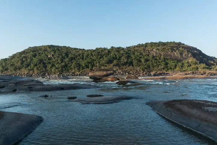
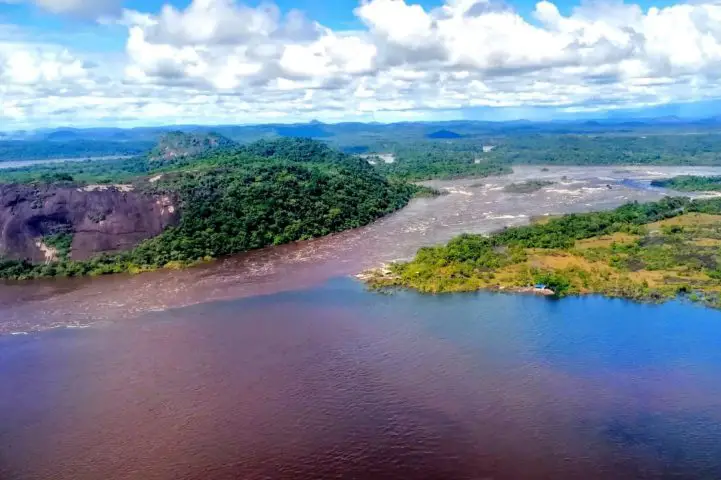
The Raudales de Maipures on the Orinoco River and at the mouth of the Tuparro River, is one of its main attractions. The Orinoco river narrows in this area and its current flows thunderously between giant rocks that extend up to 5 km.
How to Get to Tuparro National Natural Park
Via Bogotá-Puerto Carreño
Take a 1-hour flight from El Dorado International Airport (BOG) Bogotá to German Olano (PCR) at Puerto Carreño city with Colombia´s state own airline: Satena.
Once at the airport, take an approximately 45- minutes ride to Casuarito Port. Once at the Port you should take an extra 10-minutes boat ride to Puerto Ayacucho (Venezuela). Finally in Puerto Ayacucho you should take an extra 15-minutes boat ride to Tuparro.
Via Bogotá- Villavicencio
Take a 1,2-hours flight from El Dorado International Airport (BOG) in Bogotá to Vanguadía Airport (VVC) at Villavicencio city with Satena Airline. In the airport take an approximately 1h1min flight to to German Olano (PCR) at Puerto Carreño city with Satena Airline.
Once at the airport, take an approximately 45- minutes ride to Casuarito Port. Once at the Port you should take an extra 10-minutes boat ride to Puerto Ayacucho (Venezuela). Finally in Puerto Ayacucho you should take an extra 15-minutes boat ride to Tuparro.
What to do in Tuparro National Natural Park
During the induction talk, visitors are informed about the activities carried out in El Tuparro National Natural Park, the conservation objectives, the services offered, and the ecotourism activities that can be carried out.
Hiking and Trekking
Hiking is the most exciting activity in Tuparro National Natural Park. The Attalea (Maipures) trail has a length of 3 km uphill through a palm forest and rocky outcrop. Moderate intesity. When you reach the highest point you can have the view of the Raudal Maipures. This trail is currently being managed by local indigenous communities.
The Eighth Wonder of the World Tuparro Natural Park
The Raudal de Maipures and the Balancín
Formerly called Quituna by the indigenous people of the region, the waters of the Maipures raudal belong to the great Orinoco River. There, this riverbed marks part of the extensive border limits that separate Colombia and Venezuela.
Maipures is one of the most impressive attractions that El Tuparro National Natural Park offers to its visitors. In the 19th century, specifically in 1800, the famous German naturalist Alexander von Humboldt passed through the Maipures stream. He called this place “the eighth wonder of the world”. Among its main attractions, undoubtedly, is the “Balancín”, in the sector of the Atarrayadero, a rock that remains suspended over another, despite the strong currents with which the great Orinoco lambastes there.
The best time to enjoy all the splendor that Maipures offers is during the summer months (low water season due to the few rains that fall in this region), that is, between the months of December and March.
Birdwatching and Wildlife Tours
El Tuparro National Natural Park is a perfect place for those interested in fauna and flora. However, it is not easy to spot wildlife because most of them have crepuscular habits (dawn and dusk) and are elusive.
Birdwatchers will be able to enjoy some of the species since there are records of more than 300 species of birds. Research and monitoring have found 74 species of mammals, 17 species of reptiles, 229 species of fish, and up to 828 species of plants in the protected area. Insects have not yet been surveyed, so all the data that you document during your visit (citizen science) will be of help to continue to nourish the park’s lists.
The main ecosystems present in the park are typical of the Orinoco, including dry and flooded savannah, gallery forests, riparian forests, and rocky outcrops.
Aquatic Tourism
Finishing the hiking activity through the Anaconda trail, you can go through a path in the savannah where meters ahead the visitor will find the attractive blue well, ideal for a refreshing swim. The bathing activity can also be developed in the attractions of Bocas del Tomo, Raudal del Tuparro and caño Peinillas. Kayak can also be practiced in the Raudal del Tuparro.
El Tuparro
Research and Environmental Education
The protected area’s exuberant biodiversity and its conservation status make it a suitable place for scientific research. In addition, activities related to the Environmental Communication and Education Plan are carried out in coordination with educational institutions and in the development of the lines prioritized for the fulfillment of the institutional mission.
Where to stay in Tuparro National Natural Park
Tuparro Natural National Park does not currently offer accommodation for travelers, but it is possible to stay in Puerto Carreño. Therefore we recommend the following hotels:
El Lago
Cacique Samanare
Voragine
Best Time to Visit Tuparro National Natural Park
The best time to visit El Tuparro is the dry season which starts at the beginning of June until late of September and from the beginning of April until late of November, with temperatures around 25º C (77 ºF).
Tuparro National Natural Park Entrance fees
The entrance fee varies depending on the nationality and age of the visitors. These are the entrance fees for 2021:
Colombians, resident foreigners and tourists from Bolivia, Ecuador and Peru (ages 5 to 25): COP 10,000
Colombians, resident foreigners and tourists from Bolivia, Ecuador and Peru (over 25 years old): COP 16,000
Non-resident foreigners (over 5 years old): COP 46,500
Children under 5 years old and Colombians over 65 years old have free entrance presenting their IDs.
Before Visiting Tuparro National Natural Park Consider:
The entrance of Visitors only will be allowed if it is accompanied by an authorized touristic operator that meets the law requirements, the visitor who enters the park without a touristic operator will be returned by the Staff of the protected area.
Due to the security of the visitors and uncomfortable situations that have been presenting with our neighboring country, national parks authorities recommend not traveling to Venezuela.
You should avoid taking harmful elements that go against biodiversity, such as aerosols, guns, alcoholic beverages and hallucinogen substances.
The staff of the Park reserves the right of entrance and/or permanence to the people that are not mentioned in the entrance permit, this measurement also works for the cases when the total number of people does not matches the number indicated in the permit.
Due to evacuation of BIODEGRADABLE trash (bottles, batteries, cans, etc.), it is necessary to carry plastics bags.
If you enter through Venezuela, you must do so through a registered tour operator and under their security.
Consider wearing personal protective items (sunscreen, sunglasses, towel, insect repellent, and hat).
Bring along valid identification documents and health insurance.
It is recommended to be vaccinated against yellow fever, measles and tetanus.
If you take specific medications, take them with you a personal first aid kit.
Photos or videos for commercial or publication purposes must have prior permission from Parques Nacionales. The use of DRONES is not permitted in the Protected Areas for filming and/or photography activities of a private-recreational nature, without prior authorization.
Some prohibitions
Feeding, bothering or hunting animals, alcoholic drinks and drugs, throwing cigarette butts, burning garbage, felling, and capturing wildlife.
The current director of Sula. Doctor in Biological Sciences. Her main interests are to explore and understand the organism-environment interactions, taking advantage of emerging knowledge for the management and conservation of species and ecosystem services. She is currently working as a consultant in functional ecology, ecosystem services, and conservation projects in Colombia related to ecotourism and birdwatching.
Luisa Martin
Engineer, world traveler, amateur photographer, traveling blogger, and foody.
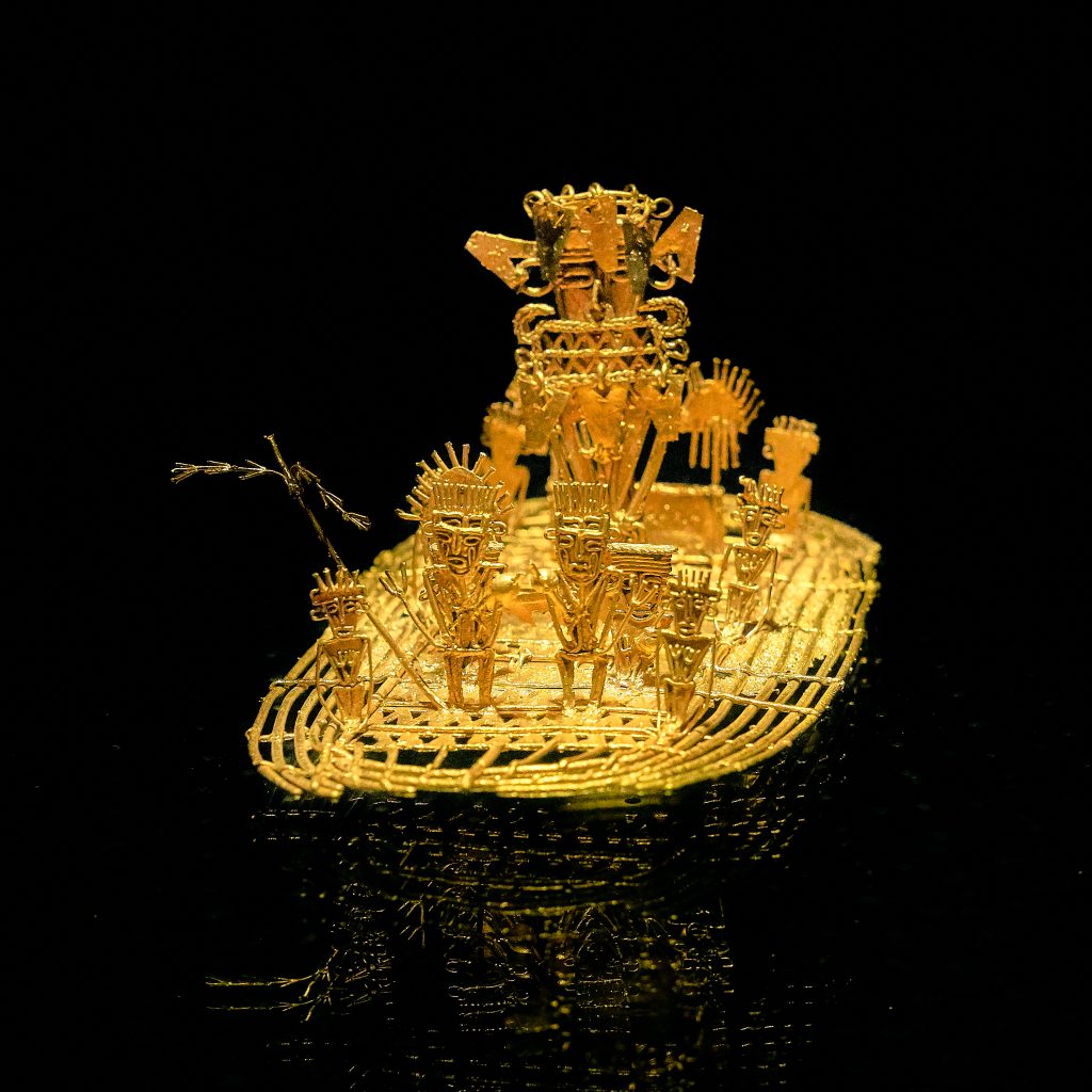
The Guatavita lagoon was one of the most sacred of the Muiscas, since the ritual of investiture of the new Zipa (Cacique- chief) was carried out there. This is one of the origins of the El Dorado Legend. The famous Muisca Raft that is exhibited in the Gold Museum of the Bank of the Republic of Colombia is evidence that this type of ritual was celebrated in the lakes of the region. Find out more about the museums of Colombia in The 117 Museums Guide of Colombia for Culture Travelers travel guide.
Guatavita comes from the Chibcha language GUA-TA-VITA, which translated into Spanish means “tillage of the tip” or “end of the mountain range”, as stated by the linguist Joaquín Acosta Ortegón in his Chibcha dictionary. The Chronicler Fray Pedro Simón, in his “Historical News”, said that Guatavita was called Guatafita, which means “thing set on high”, stating that it was the Spaniards who made the change from F to V to give it more phonetic sweetness to that name.
Origins of El Dorado Legend
According to the Muisca tradition, in Guatavita the cacique Sua was married to a beautiful princess from another tribe. Sua was very fond of chicha and bacchanals, and his wife, with whom he had a daughter, fell in love with a warrior who was courting her.
The lovers were caught by Sua, and he subjected the warrior to horrendous tortures, to the point of taking his heart out and serving it to his wife. The woman fled in despair, took her daughter in her arms and dove with her into the lagoon.
The cacique ordered the priests to recover his family. They informed him that the woman was now living under water, where a large snake had betrothed her. The cacique demanded that his daughter be brought to him, and they brought him a child without eyes. Sua, disheartened, returned her to the waters and ordered that from that day on, the best emeralds and gold filigrees be thrown into the lagoon (if you want to know about filigrees watch our video Santa Fe de Antioquia). The purpose of the ceremony was to beg the queen to ask the gods for prosperity and bonanza for her people.
Every full moon, Guatavita’s snake emerged from the waters to remind the people about the offerings, the priests watched his appearance as a sign of prosperity.
The Golden Indigenous
El Dorado Legend, gold statue at the Gold Museum, Bogotá, Colombia, picture by Pedro Szekely, from flickr, CC BY-SA 2.0. Wikimedia.
With the Spanish invasion, the ritual acquired a new meaning. They were told that a ritual was carried out when a new cacique, usually the nephew, son of a sister of the previous cacique, was in power.
The heir prepared himself within a six years period before the ceremony. He had to purified himself through fasting, and confined himself in a cave where he could not see the sun or eat food with salt or chili.
Some chroniclers have narrated it this way:
“…In that Guatavita lagoon, a great raft of reeds was made, decorated as brightly as possible… They undressed the successor, smeared him with a sticky soil and sprinkled him with gold powder and ground, so that in the raft everything was covered with this metal…
The golden indigenous man made his offering by pouring all the gold and emeralds he carried into the middle of the lagoon, and the four chiefs who went with him did the same. During the way back to land in the raft, they started a party, with bagpipes and “fotutos”, with dances in their own way, with which ceremony they received the new cacique who was recognized as lord and prince …”
From this ceremony was taken that so celebrated name of El Dorado.
The Search for the Treasure
The history of the “golden indigenous” gave rise to the “El Dorado”, a mythical place that the conquistadors sought from the Andes to the Amazon, with such eagerness that within a week, in 1539, three expeditions led by Sebastián de Belalcázar, Nicolás de Federmán and Gonzalo Jiménez de Quesada, from Peru, Venezuela and Santa Marta, respectively, coincided in Guatavita.
There were several attempts to drain the lagoon to find its hidden treasures, among which the most important were that of Captain Lázaro Fonte, who was able to extract several pieces of fine gold, and that of Antonio de Sepúlveda in the 16th century, who also managed to remove emeralds and ceramic pieces.
In 1580, a merchant named Juan Sepulveda employed 5,000 indigenous men and dug a canal to drain it. The water level dropped as much as 20 meters, but then the canal collapsed and the King of Spain refused to continue financing the enterprise. Sepulveda had to abandon, despite having rescued several pieces of filigree and an emerald the size of a fist.
Unsuccessful attempts continued throughout the colony, but the legendary gold continues to fuel treasure hunters’ dreams to this day. In an old German book published in 1911, for example, there is even a photograph, supposedly real, of the totally drained lagoon.
In the book is narrated that some W. Cooper, representative of the English company Contractors Limited, had shown two German tourists photographs of objects taken from the lagoon as rings, snakes, frogs and men’s heads, made of gold. This Cooper told them that the value of the gold found since 1909 amounted to at least 500 pounds, which paid several times the investment of the expedition.
Recovery of Guatavita Lagoon
What is certain is that the Guatavita lagoon, when you visit it for the first time, is smaller than you could imagine… given the size of the legend!. But the sad thing is that this happened after it was emptied of more than half its contents by gold diggers, English and Germans, among others, until the end of the 19th century. These treasure hunters opened a hole in the mountain to drain the water to take out the gold pieces that rested at the bottom of the lagoon.
Fortunately, the failure of all these expeditions appeased the greed of the gold diggers. Initially, the place was reduced to abandonment, and at the beginning of the 21st century the park was closed to the public to try to recover it.
Today, a good part of its splendor has been reborn, with the frailejones, bromeliads, lichens, arnicas and multicolored mosses. The true treasure is the lagoon and the páramos of Colombia, because from there the water flows to all the surrounding regions.
Currently, the lagoon is located in an environmentally protected area where you can access a trail that crosses an impressive mountainous area, full of vegetation and typical species of the Colombian páramo.
We recommend you to visit the Guatavita Lagoon after visiting the Golden Museum in Bogotá.
How to Get to Guatavita Lagoon
Guatavita town is located 75 kilometers northeast of Bogotá, bordering the municipalities of Sesquilé and Machetá to the north; Gachetá and Junín to the east; Guasca and Sopó to the south; and Tocancipá and Gachancipá to the west.
However, Guatavita Lagoon is 8 km from the road that borders the Tominé reservoir, besides the town.
The Guatavita lagoon today is a Regional Natural Reserve of the System of Protected areas of Colombia. Entrance fee for foreigners is around of 13,000 COP (3.5 USD). After paying, you will be led by a local specialized guide, in small groups, through a natural path along the paramo.
Local guides are from the Muisca community which still inhabits the region.
Accomodation near Guatavita Lagoon
You can find accommodation in the town of Guatavita or in the nearby parks associated with the reservoir circuit that exist throughout the region. This accommodation, offered by the parks, is of the shared cabin type, with a minimum cost of 215,000 COP (60 USD), depending on the number of people.
Recommendations
To enjoy it to the fullest, we recommend you take comfortable, warm and waterproof clothing, as the average temperature of the place is 13ºC and rainfall is frequent. However, none of this will prevent you from having a deep connection with nature and with the ancestral past that this lagoon hides, and that makes it an authentic cultural heritage of the country.
If you want to know more about Colombian nature tours, or want to visit Guatavita Lagoon, follow us, write us comments, or just contact us.
Current director of Sula. Doctor in Biological Sciences. Her main interests are to explore and understand the organism – environment interactions, taking advantage of emerging knowledge for the management and conservation of species and ecosystem services. She is currently working as a consultant in functional ecology, ecosystem services and conservation projects in Colombia related to ecotourism and birdwatching.
Tayrona is one of the most important, and probably the most famous,National Natural Park in Colombia. Most tourists coming to Colombia pay a visit to this park that boasts spectacular beaches apt for adventure sports and an unforgettable getaway. This is definitely a must–visit destination on your Colombia holiday.
In this post, you will find all the information you need to know to visit the amazingTayrona Park in Colombia, such ashow to get there, the best time to visit, what you can do there, and some recommendations.
Discovering Tayrona Park
Tayrona is a protected area of 150 square kilometers (58 sq mi) in northern Colombia with stunning landscapes and biodiversity. It comprises both the sea territory on the Caribbean Sea and the coasts that plunge into the wild jungle that hosts the highest coastal mountain on earth – the Sierra Nevada de Santa Marta.
Flora and Fauna at Tayrona Park
In Tayrona, you can find several bays such as Chengue, Gayraca, Cinto, Neguanje, Concha, Guachaquita, white-sanded beaches, and mangrove swamps around them, dry, rain and cloud forests, and marine ecosystems such as coastal lagoons, rocky shores, coral reefs, among others.
In fact, the park has one of the best conserved dry forest in the country. The plant diversity is huge – species such as Ceiba or sandbox tree (Huracrepitans), Trupillo (Prosopis julliflora), Aromo (Acacia tortuosa), Brasil (Haematoxylonbrasiletto), Caracolí (Anacardium excelsum), Higuerón(Ficus sp.)and avocado (Perseaamericana)grow in the park.
Wildlife present in Tayrona Park is also worth mentioning. The place is a paradise for birders since 396 bird species can be spotted, from shorebirds to high mountain birds, among which are the Rufous-vented Chachalaca (Ortalis ruficauda), Blue-billed Curassow (Crax alberti), Sapphire-bellied Hummingbird (Lepidopyga lilliae), Brown-throated Parakeet (Eupsittula pertinax) just to mention some of the forest ecosystem.
As for the mammals, 59 species are recorded, including the Grey-bellied night monkey (Aotuslemurinus), White-fronted capuchin monkey (Cebus albifrons),Howler monkey (Alouatta seniculus),sloth (Bradypus variegatus), armadillo (Dasypusnovemcinctus), Red brocket deer (Mazama americana), jaguar (Panthera onca), ocelote (Leoparduspardalis), anteater (Myrmecophagatridactyla), as well as 40 species of bats and 5 marine mammal species.
Reptiles include the Green, Loggerhead, Hawksbill, and Leatherback sea turtles, the iguana, the American crocodile,and the boa constrictor are found.
Indigenous at Tayrona Park
Tayrona is outside the territory of indigenous reserves, so no indigenous communities live there. However, the 4 indigenous communities that inhabit the Sierra Nevada de Santa Marta(Kankuamo, Kogui, Wiwa, and Arhuaco) consider the coastal and lagoon zones within Tayrona as part of the sacred ancestral territory.
This land must be respected as part of the cultural heritage of humanity and therefore protected by all visitors. Although a nature area shouldn’t be named an ancestral territory or a protected area for us to preserve it!Check other National Parks in Colombia open for ecotourism
How to get to Tayrona Park
Tayrona Park is 34 km (21 mi) from Santa Marta, in the Magdalena department, on the Colombian Caribbean coast.Access from the city is easy. If you haven’t organized a private transfer, you can take a taxi or a bus (usually leaves from the city’s market) and go on the Santa Marta – Riohacha route (called Troncal Caribe) for about 50 minutes. There are 3 entrances:
El Zaino Entrance
El Zaino is the main entrance and allows you to access the following beaches in this order: Castillete, Cañaveral, Arrecife, Arenilla, La Piscina, Cabo San Juan, the Nudist Beach (Boca del Saco) and Playa Brava.
Neguanje Entrance
If you plan a day trip and are not staying in the park, you can get to the Neguanje entrance (kilometer 5 on the same road to La Guajira), from where you can reach Chengue, Gayraca and Playa Cristal beaches.
Calabazo Entrance
Last, 2 km before getting to the Zaino entrance is Calabazo. This is the entrance to reach the ruins of Pueblito, after a 3-hour hike. If you continue the hike, you get to Cabo San Juan and Playa Brava.
By Boat from Taganga
Access to the park by boat is also possible. The boats leave from the village of Taganga, 5 km from Santa Marta, and take about 45 minutes to drop you in Cabo de San Juan area.
Best time to visit Tayrona Park
For quieter beaches and easily available accommodation, schedule your visit to Tayrona Park in September, October, and November.
Like all tourist destinations in Colombia and the whole world, Tayrona Park gets really crowded during the peak seasons. Peak season in Colombia occurs from June to July and December to February.
Additionally, the holy week,8 days, is held in March or April. It is better to avoid these moments and all holiday long weekends if you want to access relatively lonely beaches.
You should also check the ParquesNacionaleswebpagebeforehand because the park closes for one month (usually January or February) every year.
As for the weather,May, July, September, and October are the rainiest months, but rain is occasional and does not greatly affect your plans, while the dry season may restrict bathing on some beaches.
What to do in Tayrona Park
Lost City – Tayrona Park, Santa Marta
Beaches
In Tayrona, white sandy beaches with crystal waters surrounded by mangrove swamps and forests are the main attractions. The most visited ones are:
Cabo San Juan del Guia, which is beautiful and huge,
La Piscina (large shore and calm waves),
Arenilla (the small zone between Arrecife and La Piscina),
Cañaveral (where you find Ecohabs Tayrona, although you cannot swim in there),
La Piscinita(small zone next to Cañaveral apt for baths), and
Arrecifes (also not allowed to swimmers but with several campsites).
Hiking
There are 4 hiking trails that go from low to high difficulty and from 1 to 4 hours.
Kogui or Knowledge trail from Cañaveral to Arrecifes (low difficulty, one hour).
Arrecifes– Boca del Saco trail going through Arrecifes beach, the natural pool and Cabo San Juan del Guía (low difficulty, 2 hours).
The stone road to Pueblito from Cabo San Juan del Guía (high difficulty, 3 hours).
Calabazo – Pueblito – Cabo San Juan del Guía trail (highdifficulty, 4 hours).
Submarine fun
For those who are more adventurous, snorkeling and diving are available too. The areas for scuba diving are Isla Aguja and Granate, this activity is managed by the diving schools of the village of Taganga.
You can snorkel in Neguanje, in front of Playa del Muerto, or in the Tayrona natural pool. At Gayraca bay you can dive and snorkel.
Birdwatching
As mentioned above, birdwatching in Tayrona Park is one of the best activities since there is a huge diversity of avifauna.
Fauna and Flora observation
Other animals that can be observed here are the howler monkey, cotton-top tamarin, deer, ocelot, and the jaguar, reptiles such as the blue poison dart frog, iguanas, and the American crocodile. Playful dolphins cheer lucky tourists too. Local flora includes evergreen trees, moss, bromeliads,and orchids.
Pueblito
Other activities are observation of cultural and archaeological heritagein architecturally important areas. One of them is Pueblito, where you can find ruins of the Tayrona ancient indigenous civilization, after a hike that takes about 3 hours. Its stone structures such as terraces, paths, and stairs are well-conserved.
Where to stay in Tayrona Park
There are different types of accommodation in Tayrona Park for all tastes and budgets.
Lodges
Cañaveral sector: 14 ecohabs (eco-lodges), all for double accommodation, but 11 with an option for extra beds for up to 4 people in family accommodation. Designed like the traditional indigenous houses with views to the Cañaveral beach.
Los Naranjos:ecohabs in FincaBarvolento, 2 minutes from Los Naranjos beach. 8 cabins with a private bathroom and terrace. There is also a private house on this beach, 5 minutes from the main entrance of the park.
Arrecife: 2 independent cabins, each one for up to 5 hosts, in Arrecife beach.
Camping zones
Several beaches offer zones to set a tent or a hammock and spend the night under the starred sky. These are:
Cabo San Juan offers a public bathroom and a restaurant. A small station of the Colombian Civil Defense is located there.
Playa Brava: a remote beach, 4 or 5 hours walking from Zaino o Calabozo, with public bathrooms, cabins, and a small restaurant.
Arrecife: the best beach to camp, near the police and Civil Defense stations and with a great restaurant. The camping area doesn’t have views of the sea, though.
Cañaveral: area without views of the sea, near La Piscinita.
Castilletes: Finca with large camping zones, public bathrooms, and a restaurant. Bathing in this stretch of sea is not allowed. You can get there directly by car.
Bahia Concha: the camping zone is shaded by large trees and the sea is calm and crystalline. You can get there directly by car.
Tayrona Park 2020 Entrance fees
The entrance fee to Tayrona National Natural Park varies depending on the nationality and age of the visitors, as well as the season of the year. These are the entrance fees for 2020:
Peak Season
(15 June – 15 July, 15 December – 15 January, Holy Week and long weekends)
Colombians, resident foreigners, and tourists from Bolivia, Ecuador, and Peru (ages 5 to 25): COP 20,000
Colombians, resident foreigners, and tourists from Bolivia, Ecuador, and Peru (over 25 years old): COP 28,500
Non-resident foreigners (over 5 years old): COP 63,500
Low Season
Colombians, resident foreigners, and tourists from Bolivia, Ecuador, and Peru (ages 5 to 25): COP 18,000
Colombians, resident foreigners, and tourists from Bolivia, Ecuador, and Peru (over 25): COP 24,000
Non-resident foreigners (over 5 years old): COP 53,500
People born in Santa Marta (ages 5 to 25): COP 9,000
People born in Santa Marta (over 25 years old): COP 12,000
Children under 5 years old and Colombians over 65 years old have free entrance.
Additionally, depending on the vehicle you enter to the park in, you have a different fee:
Car: COP14,500
Van: COP37,000
Bus:COP 78,000
Motorcycle: COP10,000
What you should consider when you visit Tayrona Park
Entry hours are from 8:00 am to 5:00 pm.
The park has a daily capacity of 6,900 tourists, so make your reservations in advance.
Having yellow fever and tetanus vaccines is recommended.
Always carry your ID, it is required at the entrance.
The introductory talk about environmental education is mandatory.
The climate in the park and surrounding areas is tropical hot, with temperatures ranging from 27 to 35 °C (81 to 95 °F). Therefore, use light cotton clothes, preferably pants and long-sleeve shirts. Also, wear appropriate hiking shoes, water–resistant if possible.
Bring a cap, sunglasses, sunscreen, insect repellent, and a lantern.
Only swim in permitted areas. Bathing in the sea is allowed until 6 pm.
Access to the indigenous sacred places is forbidden
If you hire a guide, make sure they are certified and preferably local.
Don’t bring any plastic bags, alcoholic drinks, instruments, and pets to the park, these are not allowed. Also don’t leave garbage (even organics) anywhere.
#BreatheTayrona – During January/February, the Tayrona Park closes its doors for allowing the restoration of its ecosystems, by the request of the indigenous communities in the Sierra Nevada de Santa Marta. Check the status of the park before your trip.
Current content writer for Sula. Modern Languages professional with an emphasis on business translation. Interested in the cultural adaptation of written and audiovisual content. Passionate about knowing new cultures and languages, tourism, and sustainable living.
Colombia is the second most biodiverse country in the world —and the most biodiverse country per square meter—. This is a privilege not many countries have and Colombia understands how lucky it is for its natural richness.
In fact, it has a National System of Protected Areas (SINAP in Spanish) with a huge network of national parks and sanctuaries. SINAP is a program that protects 1.116 areas equivalent to 15% of the national territory. It includes all protected areas under public, private or community governance and under national, regional or local management.
The National Natural Parks System
Within the system, there is an entity in charge of managing the protected areas and implement the required policies and strategies to pursue the goal of nature conservation in the country.
It is called the National Natural Parks System and comprises 59 natural areas that represent over 14,200,000 hectares (+142,000 km2) of the national area (land and marine).
The Colombian cultural wealth is also present in the system, as 26 out of the 59 areas are inhabited by indigenous and Afro-descendant peoples.
These protected areas are divided into 5 categories:
National Natural Park (PNN),
National Natural Reserve (RNN),
Unique Natural Area (ANU),
Fauna and Flora Sanctuary (SFF), and
Parkway (Vía Parque).
We will focus on defining the national parks and the sanctuaries.
National Natural Park (PNN): extension area whose ecosystems have not been substantially altered by human occupation or exploitation, that can have ecological self-regulation and whose plant and animal species, geomorphological complexes and historical or cultural manifestations are of scientific, educational, aesthetic and recreational value.
Fauna and Flora Sanctuary (SFF): area dedicated to the preservation of wild animal and plant species or communities to conserve genetic resources of the national fauna and flora.
There are currently 23 stunning parks and sanctuaries you can visit, since they are open for ecotourism and offer several activities for a respectful interaction with nature.
Read on to know about the open national parks that shelter Colombia’s biodiversity!
Ecotourism in National Natural Parks
In Colombia you can find a variety of climates, landscapes, flora and fauna depending on the region you are traveling. There are 6 natural regions and each of them host several national natural parks that offer ecotourism possibilities.
This region comprises the islands and cays that belong to Colombia’s territory in the Caribbean Sea and the Pacific Ocean. The most famous ones are San Andres, Providencia and Santa Catalina islands, El Rosario islands, Gorgona and Malpelo. In each of these islands, there is a protected area, due to the high diversity of fauna and flora that inhabit ecosystems such as colorful coral reefs and tropical rainforests.
Old Providence McBean Lagoon National Natural Park
Area
1,648 ha
Altitude
0 – 80 m.a.s.l
Temperature
Warm weather 25°C (77°F)
Status
Open to the public
Entry fee
Non-resident foreigners over 5 years old COP $19,000
Facilities
Accommodation and restaurant services on Providencia and Santa Catalina islands.
The small Iron Wood Hill, surrounded by the McBean mangrove swamp, makes up the Old Providence McBean Lagoon National Park.
It protects nothing but the second largest coral reef in the Caribbean, and this formation along with the reef lagoon in front of the mangrove produce in the sea an array of colors from deep blue to translucent aquamarine that gives it the name of “the sea of 7 colors”.
Corales del Rosario y de San Bernardo National Natural Park
Area
120,000 ha
Altitude
0 m.a.s.l – 50 m deep
Temperature
Warm weather, 27 – 30°C (80.6 – 86°F)
Status
Open to the public
Entry fee
Non-resident foreigners over 5 years old COP $9,500
Facilities
Accommodation in rooms, hammocks or camping zone, restaurant. Services provided by the community business Nativos Activos.
South of the walled city of Cartagena, this National Park lies and covers 4 islands and a large marine zone in the Caribbean Sea. What you can find here is the most extensive and diverse coral reef in the entire Colombian Caribbean continental coastline.
Colorful organisms give life to the ocean of crystal-clear water and white-sand beaches, as unique mangroves and sea grasses complement the landscape.
Notice: It is advised to be vaccinated against yellow fever 10 days before the planned trip date and carry immunization records.
Malpelo Flora and Fauna Sanctuary
Area
2,667,907 ha
Altitude
0 – 330 m.a.s.l
Temperature
Hot and humid weather 25°C (77°F)
Status
Open to the public
Entry fee / day
Entry fee / day Divers or instructor $116,000 – $216,000 / Vessels $65,000
Facilities
Tour vessels offer accommodation, restaurant, scuba diving and necessary resources.
The Sanctuary was established in 1995 on the Malpelo island, which is about 500 kilometers west of the port of Buenaventura, and now it is the 9th largest protected marine area in the world as it was declared a World Heritage Site by the UNESCO in 2006.
It has 4 other national and international acknowledgments as an area of marine importance which make it a literal “marine jewel”.
How to get there
From the Buenaventura port, it is a 36-hour trip by boat. Currently, there are only 3 authorized tour operators that offer the tour in specific dates, so you should prepare your visit beforehand.
You can also get to Malpelo from ports in Costa Rica and Panama.
Activities
Diving is one of the preferred activities in Malpelo, but it requires a duly certified lead diver with knowledge of the area for each 6 people and all divers must have an advanced diver certification, or two-star certification, with at least 35 recorded dives, plus the minimal safety equipment.
It is also a place for research and environmental education since there are species such as the hammerhead shark, the devil ray, the masked booby, the alligator, the land crab and the gecko.
Photographs and videos with commercial purposes can be taken only with a previous permit.
Gorgona National Natural Park
Area
61,687 ha
Altitude
0 – 330 m.a.s.l
Temperature
Hot and humid weather 25 – 30°C (77 – 86°F)
Status
Open to the public
Entry fee
Entry fee Non-resident foreigners over 5 years old $53,000
Facilities
Accommodation, restaurant and transportation
It is well-known for its biological richness in an area of more than 600 km2 that is made up by 2 islands: Gorgona and Gorgonilla. It has two of the most biodiverse tropical ecosystems: coral reefs and the tropical rainforest.
What today is a major nature tourism destination used to be a maximum-security prison built in the 1960s that operated for 25 years. Some call it “Science Island” for all the information it has given researchers to understand the ecosystems and effectively manage the protected area.
How to get there
By plane: 4-hour connection flight from Bogota to Guapi. TAC and SATENA operators offer a daily round trip from Cali and Tumaco respectively.
By boat: You can book a boat service from Guapi that will take you to the island in an hour and a half up to 2 hours. Otherwise, from the Buenaventura port, there are speedboat services that offer round trips for groups of over 10 people.
Activities
Gorgona offers the public activities to enjoy during the day such as hiking, bird watching, snorkeling, scuba diving, fauna, flora and cultural heritage observation and serves as a place for scientific research and environmental education as well.
Some of the species that can be found include snakes, frigate birds, pelicans, different sea fish, dolphins, marine lions and the humpback whales that come each year to give birth.
Temperature 23 – 30°C (73.4 – 86°F) / Hot and humid weather
Status
Partialy closed – only day-pass activities
Entry fee
Entry fee Non-resident foreigners over 5 years old $55,000
Facilities
Tour guide and environmental interpretation
Utría Ensenada is located on the northern Pacific coast of Colombia, in the department of Chocó.
To the south, the visitor will observe the mountains covered with lush tropical rainforest that ends directly at the sea.
The park receives the arrival of migratory species such as sea turtles, birds and whales and the ideal site for spawning fish such as the Ensenada marlin (Tylosurus acus pacificus).
How to get there
By plane: You can reach Bahía Solano or Nuquí by plane from Bogotá or Cali (with transit in Medellín).
By boat: from Buenaventura you can get to Bahía Solano, Nuquí or El Valle by coastal boat, which takes 26 hours; from there it takes between 30 and 50 minutes to get to the park by boat. Maritime transportation must be arranged in advance with tour operators in the area, and the price varies according to the number of passengers on the boat.
By land: it is possible from Bahia Solano, arriving first to the village of El Valle by bus for 40 minutes, and from there on foot to the park through a tropical rainforest trail, in a journey of approximately 3 hours.
Activities
Utría offers magnificent beaches and the relaxing panorama of a deep blue sea. Those who are attracted to more exciting activities can enjoy hiking, swimming, snorkeling and scuba diving.
Farallones de Cali National Natural Park
Area
196,429 ha
Altitude
200 – 4,100 m.a.s.l
Temperature
Cold to Warm / 5 – 25°C (41 – 77°F)
Status
Open to the public with controlled access
Entry fee
Entry fee Non-resident foreigners over 5 years old $27,500
Facilities
Tour guide and environmental interpretation
During sunny days in Cali, you can see the peaks of Farallones de Cali, the youngest rock formations on the Western Range of the Andes. They rise from the plains separating the basins of the Pacific and the Cauca river, forming the greatest protected area in the department of Valle del Cauca.
This place not only houses over 540 bird species and the spring of 30 rivers that supply Southwestern Colombia, but it is a diversity reservoir of unique and threatened species in the country and the world.
How to get there
It is southwest of Valle del Cauca and comprises the towns of Cali, Jamundí, Dagua and Buenaventura.
Activities
There are 3 hiking trails for you to discover the natural beauty of this national park: Burbujas, Pico de Loro and Peñas Blancas from low to medium-high difficulty.
Also, you can enjoy the natural pools that go from 80 cm to 6 m deep in Cañón del Anchicayá, an activity that requires previous reservation.
Wildlife lovers can do observation tours where they can find the spectacled bear, 6 feline species (puma, panther, ocelot among them), different primates, snakes, amphibians such as the Lehmann’s poison frog and birds such as the long-wattled umbrellabird, multicolored tanager, yellow-green tanager, Cauca guan and Andean cock-of-the-rock.
Uramba Bahía Málaga National Natural Park
Area
47,094 ha
Altitude
0 – 20 m.a.s.l
Temperature
Tropical hot weather / 18 – 25°C (64.4 – 77°F)
Status
Open to the public
Entry fee
No fee
Facilities
Accomodation and food services are offered in nearby villages.
This park located in the middle of the Colombian Pacific coast, belonging to the municipality of Buenaventura, in Valle del Cauca department.
It is also a preferred destination to watch the spectacular arrival of the humpback whales each year, when young natives from the local communities work as environmental interpreters. A huge amount of fauna and flora species are found here too.
The Andes mountain chain crosses the center of the country, creating unique ecosystems for each height. This region has 8 National Natural Parks that you can visit!
It is the most populous region of Colombia and contains the majority of the country’s urban centers.
El Cocuy National Natural Park
Area
306,000 ha
Altitude
600 – 5330 m.a.s.l
Temperature
Cold to temperate weather / 0 – 20°C (32 – 68°F)
Status
Open to the public
Entry fee
Entry fee $73,500
Facilities
Food service in the homes of farmers and local guides
The Sierra Nevada de Güicán, El Cocuy and Chita is the largest glacier mass in Colombia, with more than 25 snow and ice peaks within two mountain ranges of approximately 30 kilometers long and 4 wide.
Here you can find moorlands and a strip of Andean and basal forest that host a wide range of fauna and flora. This is also a sacred place to the Uwa indigenous community and for this reason the area of the indigenous reserve (eastern side of the park is closed to tourism).
The park rangers are committed to educate visitors about wildlife and its conservation.
How to get there
There are three land routes to access the tourist area on the western side of the park:
From Bogota: 440 km – approx. 11 hours following the route Tunja, Duitama, Santa Rosa, Cerinza, Belén, Susacón, until reaching Soatá. From there, you can follow the Tipacoque or the Boavita route that lead to El Cocuy or Güicán. From these towns, it takes between 1 and 2 hours to get to the main entrances of the park on unpaved roads, in regular condition, suitable only for campers and high vehicles.
From Bucaramanga: 8 to 12 hours. Get to the town of Málaga, then to Capitanejo, El Espino, Panqueba and finally El Cocuy or Güicán.
From Llanos Orientales: 10 to 12 hours by Yopal, Sogamoso, Duitama, Belén, Soatá and from there, El Cocuy or Güicán. Or 8 hours by Tame, Sácama, Chita until El Cocuy.
Notice
Visitors must purchase an all-risk policy for entering and staying in the protected area.
To visit the Park you must make a reservation and pay one month in advance.
It is prohibited visiting the park by horse since they damage frailejones (endemic plant) and pollute water.
Minors under 10 years old cannot enter.
Activities
Hiking and climbing are the major attractions for expert mountaineers and there they can do rock and snow climbing as well as high mountain trekking.
The park has several trails and camping zones that allow visitors to observe condors, eagles, the Andean cock-of-the-rock, the helmeted curassow, the white-winged parakeet, the Apolinar’s wren, cougars, white-tailed deer, Andean bear, white-faced Capuchin and peccaries.
Los Nevados National Natural Park
Area
58,300 ha
Altitude
2600 – 5321 m.a.s.l
Temperature
Cold weather / 3 – 14°C (37.4 – 57.2°F)
Status
Open to the public with restrictions
Entry fee
Vehicle fee
Entry fee COP$46,500 (includes entrance, guide and insurance)
Car COP$6,500 – Van COP$19,000 – Minibus COP$38,000
Facilities
Cafe and toilets in the Northern sector / Accommodation, camping zone and auditorium available depending on the volcanic activity.
Los Nevados is located in Colombia’s coffee-growing region, in the northern volcanic complex formed by the glaciers Nevado del Ruiz, Nevado de Santa Isabel, Nevado del Tolima, and the paramillos of Cisne, Santa Rosa and Quindío.
Its rivers supply water to the farmlands and aqueducts of cities, towns and villages in the center of the country. Coming to this park, you realize why it is so important to protect its ecosystems (páramo and superpáramo, high Andean wetlands and Andean forests) for the ecological balance.
How to get there
There is access from the departments of Caldas, Risaralda, Quindío and Tolima. You can download an electronic or printable map here.
Notice
People under 6 and over 70 years old, with heart or respiratory conditions, pregnant, pets, motorcycles and buses cannot enter the Park.
Visitors must purchase an all-risk policy for entering and staying in the protected area.
You must be accompanied by an official guide of the National Park to enter the protected area.
Currently, entrance through Brisas sector (northern sector of the Park) is only allowed to Valle de las Tumbas since the Servicio Geológico Colombiano has declared Nevado del Ruiz Volcano’s activity at Yellow Alert Level (level III), so it is highly recommended that travelers consult the entity’s web page before their visit.
Plan your visit, tour operators take 3 working days to complete the reservation process.
There are some medical recommendations to consider due to high altitudes and cold weather.
Activities
There are about 20 trails with various difficulties for hiking and trekking while enjoying incredible panoramic views and crystalline bathing sites with sights of species such as cougar, northern pudú, lowland paca and mountain tapir, Andean condor, Black-and-chestnut Eagle, Rufous-fronted Parakeet, Ruddy duck and Bearded Helmetcrest hummingbird.
Isla de la Corota Flora Sanctuary
Area
16 ha
Altitude
2,784 – 2,820 m.a.s.l
Temperature
11°C (51.8°F) / Cold weather
Status
Open to the public
Entry fee
Non-resident foreigners over 5 years old COP$10,500
Facilities
Accommodation and food services are offered in Laguna de la Cocha shore or nearby villages.
This oval-shaped island Isla de la Corota is in the north of Laguna de la Cocha, an internationally important wetland according to the Ramsar Convention.
Although being the smallest protected area in the country, it belongs to the important ecological system of the lake.
You will find it is surrounded by a strip of totora (large Andean reeds) and species such as sparrows, wrens, thrushes, bats and wild mice or over 340 flora species. It is also of spiritual value for indigenous communities, traditional doctors from Putumayo and Catholics.
Iguaque Flora and Fauna Sanctuary
Area
6,923 ha
Altitude
2,400 – 3,800 m.a.s.l
Temperature
4 – 12°C (39.2 – 53.6°F) / Cold weather
Status
Open to the public
Entry fee
Vehicle fee
Non-resident foreigners over 5 years old $55,000
Car COP$14,500 Van COP$37,000 Bus $78,000 Motorcycle COP$10,000
Facilities
Auditorium, parking zone, trail guide
Iguaque Sanctuary has a vital function, as it is a source of water for nearby towns with its 7 glacier lagoons.
There, you will find the Sacred Lagoon of Iguaque, the cradle of humanity according to Muisca mythology! Legend has it that visiting this place helps cleansing the soul and purifying the spirit.
Your spiritual pilgrimage will be accompanied by mammals such as tiger cat, white-tailed deer, weasel and ring-tailed coati, and birds such as the Andean guan, typical of Andean forests, dove, band-winged nightjar, Andean toucanet, woodpecker and hummingbird.
Notice
Visitors must purchase an all-risk policy for entering and staying in the protected area.
Forests grow in 90% of the Otún Quimbaya Sanctuary, located to the west of the Central Andes mountain range in the Risaralda department.
Its beauty and biodiversity, trait of the coffee region, make this a great ecotourism destination. Plus, it is connected to other important conservation spots such as Los Nevados National Natural Park, Ucumarí Regional Natural Park and the Campoalegre Soil Conservation District through the conservation corridor called upper basin of the Otún river.
Here you can enjoy several hiking trails to observe wildlife.
Non-resident foreigners over 5 years old COP$10,500
Facilities
No accommodation or restaurant services. These facilities can be found in Telpis sector and the Civil Society Nature Reserves adjacent to the Sanctuary.
Galeras Sanctuary is a special destination in Nariño department, southwest of Colombia. The Galeras volcano is one of the most actives on the continent!
Since great part of the sanctuary is situated in an area of high volcanic threat, only Telpis Sector is open for tourism. Touring the páramo, Andean and high Andean forest ecosystems, you will find a varied fauna and flora, for example, 13 species of hummingbird.
Puracé National Natural Park
Area
83,000 ha
Altitude
2,500 – 5,000 m.a.s.l
Temperature
3 – 18°C (37.4 – 64.4°F) / Cold weather
Status
Open to the public, managed directly by the Puracé indigenous corporation
Entry fee
Vehicle fee
Non-resident foreigners over 5 years old COP$27,500
Car COP$11,500 Van COP$28,500 Bus $53,000 Motorcycle COP$5,500
Facilities
Accommodation and restaurant.
This ancestral territory and indigenous reserve, whose name means “fire mountain” in Quechua, is a volcanic zone in the Central Andes range with an essential function: it is the cradle of the main rivers of Colombia.
The Magdalena, Cauca, Patía and Caquetá rivers originate in Puraé along with 30 lagoons with clear water and several sulfur springs.
The Coconucos range has 11 volcanoes including Pan de Azúcar, Coconuco and Puracé, the only active one. This incredible landscape is embellished by the mighty Andean Condor, who only is seen by those who perform a ritual in a sacred rock to ask permission, or so they say.
Hot springs and wildlife observation are other attractions of the park.
Cueva de los Guácharos National Natural Park
Area
7,134 ha
Altitude
1,630 – 2,850 m.a.s.l
Temperature
16°C (60°F) / Cold temperate weather
Status
Temporarily closed to the public
Entry fee
Non-resident foreigners over 5 years old COP$51,500
Guácharo birds inhabit the southwest region of Colombia, staying in caves during the day and going out at night in search of food.
This area is named after these animals was the first declared national park of Colombia in 1960. As an Andean – Amazon transition ecosystem, it hosts great biodiversity, serves as transitory shelter for many migratory bids and as water producer and regulator.
Notice: Currently, Cueva de los Guácharos National Natural Park is closed to the public, check the web page or speak with an agent to consult its status when you visit Colombia.
On the north coast of Colombia, it borders the Caribbean sea and it consists of a continental plain and some island territories.
8 departments and 193 towns belong to this region, which accounts for 12% of the national territory.
The flat horizon gets disrupted by the imposing Sierra Nevada de Santa Marta and the Serranía de Perijá, bringing biological and ecosystemic diversity.
Most foreign tourists visit the Caribbean coast of Colombia, known for its luxury hotels, beautiful beaches with aquamarine water and joyful people.
Sierra Nevada de Santa Marta National Natural Park
Area
383,000 ha
Altitude
0 – 5775 m.a.s.l
Temperature
0 – 28°C (32 – 82.4°F) / Freezing to warm weather
Status
Open to the public
Entry fee
Non-resident foreigners over 5 years old COP$
Facilities
Accommodation: hammocks in Teyuna – Ciudad Perdida sector, cabins with kitchen, toilets and social areas in Estación Experimental San Lorenzo (currently closed due to maintenance)
Sierra Nevada de Santa Marta is located in an ancestral territory that was a major indigenous civilization, Tayrona, whose descendants belong to the Kankuamo, Kogui, Wiwa and Arhuaco ethnicities and still live there.
The landscape is stunning: just 42 km from the deep blue Caribbean sea, this mighty mountain rises until reaching a height of 5,775 m in Bolívar and Colón, its highest snow-capped peaks. It is separate from the Andes mountain range and is considered the highest coastal mountain in the world.
The mountain formation was declared Biosphere Reserve and World Heritage Site by the UNESCO in 1979, due to its ecosystemic diversity and cultural wealth.
How to get there
Entrance to Sierra Nevada is in Estación Experimental San Lorenzo, outside the protected area, 3 hours from Santa Marta. From this city, take a 42 km road to the village of Minca, then to El Campano and Bellavista. The first 25 km are paved, but the remaining road requires an off-road vehicle.
Notice
It is recommended to be vaccinated against yellow fever.
Entrance to the high zones of the Sierra in the route to Nevados is forbidden, by request of the Tayrona Indigenous Confederation (CIT).
Activities
There is a sacred area for the indigenous called Teyuna or “Lost City” where access is restricted but it offers a 5 day trekking route (3 going up and 2 coming down) with options for accommodation, starting from the village of El Mamey. For more info, visit here.
In San Lorenzo area, you can enjoy a less difficult hiking trail of 1.5 hours that takes you to Quebrada San Lorenzo, a 15-meter cascade full of wildlife in a Sub-Andean forest.
Birders, the Sierra has Important Areas for Bird Conservation (AICAS) in different zones of the park where the roadside hawk, the condor, the Santa Marta parakeet and the blue-billed curassow can be observed.
Wildlife includes land mammals such as the jaguar, the paramo deer and the danta or tapir. Here are 44 Colombian animal endemic species and 126 plant endemic species, plus 49 threatened species.
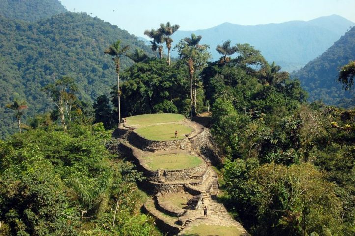
One of the sites of archaeological and cultural interest is the Teyuna Archaeological Park (Lost City), the most important historical and architectural find in Colombia, which is about 1,700 m.a.s.l. in the Buritaca river’s basin.
Tayrona National Natural Park
Area
15,000 ha
Altitude
0 – 900 m.a.s.l
Temperature
27°C (80.6°F) / Tropical hot weather
Status
Open to the public
Entry fee
Vehicle fee
Non-resident foreigners over 5 years old: COP$53,500 Low season / COP$63,500 High season
Car COP$14,500 Van COP$37,000 Bus $78,000 Motorcycle COP$10,000
Tayrona is a place where rest and contemplation are the leading principles. Here is where the foothills of Sierra Nevada de Santa Marta merge with the crystalline Caribbean sea forming gorgeous bays and coves with white sand beaches surrounded different ecosystems. Ruins of the Tayrona civilization can be also found here.
How to get there
Main entrance to Tayrona is located 32 km from Santa Marta in the direction of Riohacha and is called El Zaíno, trip lasts about 45 minutes in a private vehicle. From this entrance you can get to Cañaveral and Pueblito.
The other entrance is Palangana, on kilometer 5 of the main highway of Riohacha “Troncal del Caribe” and it takes you to Neguanje and Playa del Muerto, which are areas only for day visits.
Notice
Visitors must purchase an all-risk policy for entering and staying in the protected area.
#BreatheTayrona – During January/February, the Tayrona Park closes its doors for allowing the restoration of its ecosystems, by the request of the indigenous communities in Sierra Nevada de Santa Marta.
The park has a daily capacity of 6,900 tourists, so make your you make your reservations in advance.
It is recommended to be vaccinated against yellow fever.
Activities
In Tayrona, white beaches with crystal water surrounded by mangrove swamps, bushes and forests are one of the best attractions of the zone.
For those who are more adventurous, snorkeling and diving are available too. The areas for scuba diving are Isla Aguja and Granate, this activity is managed by the diving schools of the village of Taganga. You can snorkel in Neguanje, in front of Playa del Muerto, or in the Tayrona natural pool.
There are 4 hiking trails that go from low to high difficulty and from 1 to 4 hours.
Birdwatching is one of the best activities, since you can spot the white eagle, paujil, Tayrona bird or pobre toro, guacharaca, king vulture and royal flycatcher.
Other animals that can be observed here are the howler monkey, titi monkey, deer, ocelot and the jaguar, reptiles such as the blue poison dart frog, iguanas and the aguja caimán. Local flora includes evergreen trees, moss, bromeliads, plants from the Araceae family and orchids.
Other activities are observing cultural and archaeological heritage, since there are about 70.000 indigenous peoples and various architecturally important areas. One of them is Pueblito, where you can find ruins of the ancient indigenous civilization full of myths, after a hike that takes between 45 minutes and 2.5 hours.
Macuira National Natural Park
Area
25,000 ha
Altitude
85 – 867 m.a.s.l
Temperature
27°C (80.6°F) / Warm weather
Status
Open to the public
Entry fee
No entry fee
Facilities
No accommodation or restaurant services. You can find these facilities in some Wayuu settlements or in the villages of Nazareth and Siapana.
To the north end of La Guajira department, the Macuira mountain elevation rises as the most northern highland in South America.
Its cloud forest ecosystems works as a water regulator in the area and as an oasis in the middle of the dryness of the semi-desert area of Alta Guajira.
Thanks to the diversity of birds living in the area, Macuira was declared an Important Bird Area. Also, this place is culturally important for the Wayuu indigenous community.
Los Flamencos Fauna and Flora Sanctuary
Area
7,000 ha
Altitude
0 – 5 m.a.s.l
Temperature
27°C (80.6°F) / Warm weather
Status
Open to the public
Entry fee
No entry fee
Facilities
Restaurant, visitors center is closed.
Also in La Guajira peninsula, In Los Flamencos Sanctuary you get to see how the peaceful blue sky gets disrupted by flocks of pink feathered flamingos that brighten the sight.
This small protected area with lagoons is considered one of the most diverse in aquatic resident and migratory birds.
Notice: It is advised to be vaccinated against yellow fever 10 days before the planned trip date and carry immunization records.
Los Colorados Flora and Fauna Sanctuary
Area
1,000 ha
Altitude
230 m.a.s.l
Temperature
27°C (80.6°F) / Warm weather
Status
Open to the public
Entry fee
Non-resident foreigners over 5 years old COP$6,500
Facilities
Accommodation and restaurant services are provided in San Juan Nepomuceno village.
Red howler monkeys abound in Los Colorados mountain, this is why the Sanctuary has this name. The area consists of a small mountain range made up of sedimentary rocks and a relict dry forest -one of the mot preserved in the region- that houses primates, mammals and over 280 bird species! Thanks to this, it is also an Important Bird Area.
Notice: It is advised to be vaccinated against yellow fever before the planned trip date.
Also known as the Oriental Plains, it covers most of the area of the departments of Meta, Arauca, Casanare and Vichada. The little populated region is rich in oil and suitable for extensive ranching.
Entry fee Non-resident foreigners over 5 years old COP$53,500
Car COP$14,500 Van COP$37,000 Bus $78,000 Motorcycle COP$10,000
Facilities
Restaurant, equipped camping zone in Monterredondo, visitors center with accommodation, auditorium.
Chingaza is located on the eastern Andes, in the northeast of Bogota, it comprises municipalities in the department of Cundinamarca and in Meta.
This territory was inhabited by the Muiscas and the Guayupes indigenous groups and more recently by farmer communities.
The stories of the ancient civilizations remain in the mountains while Andean fauna and flora embellish the forests and moorlands that characterize the park.
Fun Fact: in the Muisca language, Chingaza may have been called Chim-gua-za, which means Mountains of the Lord of the Night.
How to get there
There are 3 access points, one from Guasca, one from La Calera and one from Fomeque, all towns in Cundinamarca. Find more detailed information here
Notice
Visitors must purchase an all-risk policy for entering and staying in the protected area. You must file an entrance request at least 15 days prior to the intended visit date.
Activities
You can go hiking in approximately 6 trails with 3 observation spots that allow a panoramic view of the mountain range, the Chingaza lagoon and the Condors viewpoint, wild fauna and flora watching and environmental education and research. The high Andean and sub-Andean forest and moorland ecosystems are predominant in the area.
You can observe some Colombian endangered species, such as the Andean bear, the white-tailed deer, the colored deer, the Andean condor, the wetland spotted paca, the Andean cock-of-the-rock and the cougar Puma. Plus, there are 396 bird species registered in the zone. Birders will love this site!
Sierra de la Macarena National Natural Park
Area
629,280 ha
Altitude
200 – 400 m.a.s.l
Temperature
27°C (80.6°F) / Warm weather
Status
Open to the public with restrictions
Entry fee
Non-resident foreigners over 5 years old COP$COP$53,500
Facilities
No accommodation or food services
This National Natural Park was established in La Macarena biological reserve that includes the largest geological accident west of the Guiana Highlands, the Sierra de La Macarena.
This range is 130 km long by 30 km wide! Rain forests, floodable forests, scrub and herbaceous vegetation from the Amazonian Savannah constitute the ecosystem here.
There is also historical value in this park, since petroglyphs and pictograms by ancient indigenous cultures can be found.
How to get there
By plane: Bogotá – Villavicencio is a 30-minute flight, then drive about 1 hour to La Macarena township to get to Caño Cristales.
By car: Bogotá – Villavicencio – Granada, then take the route to San Juan de Arama and upon arrival the Mesetas road to Curia, where you take to the Cerrillo sector and in the old administrative center where there are eco touristic sites of La Recebera and the Indio Acostado. To visit Caño Cristales, drive approx. 16 hours to Neiva – Florencia – San Vicente del Caguan (Las sabanas del Yari) – La Macarena.
Notice
Tourism activities are restricted in the following areas: Cristales de Colores, Pailones and Caño Cristalitos paths, until the weather conditions are favorable for the ecosystem.
Visitors are advised to be vaccinated against yellow fever 10 days prior to travelling and carrying always their vaccination record.
You must make your reservation 15 days in advance.
Activities
The first attraction of this place is Caño Cristales, also known as the 5 color river and the most beautiful river in the world, and this is because it reflects red, green, yellow, blue and black hues from June to early December. The red hues are caused by Macarenia clavigera plants, which are endemic.
Other ecotourism activities are hiking trails, wild fauna and flora watching and nature photography.
456 bird species have been registered in the park and endemic fauna you can see includes the ornate titi, the strong-billed woodcreeper, the rufous-collared sparrow, the Colombian mountain grackle, the Cundinamarca antpitta, the yellow-browed shrike-vireo, among others.
El Tuparro National Natural Park
Area
548,000 ha
Altitude
100 – 330 m.a.s.l
Temperature
27°C (80.6°F) / Warm weather
Status
Open to the public
Entry fee
Non-resident foreigners over 5 years old COP$46,500
Facilities
Accommodation and restaurant services are provided in nearby villages.
A large green savanna with powerful rivers, small spots of crystalline waters, forests and large rock formations in the shape of rounded hills, this is the landscape of El Tuparro National Natural Park.
As a National Monument and Nuclear Area of the Biosphere Reserve, the park helps sustainable development, conservation and research-education.
Attractions include the possibility to observe more than 320 bird species and the imposing Maypures Torrent, which was named as the “Eighth Wonder of the World” by Alexander von Humboldt himself!
Notice: You can only enter with an authorized touristic operator. Make sure they meet the law requirements in regard to activities such as sport fishing, which is forbidden.
You are advised to be vaccinated against yellow fever and measles.
It is located in southern Colombia over the Amazon Basin, covered by the Amazon Rainforest which is the largest of the world.
It comprises the departments of Amazonas, Caquetá, Guainía, Putumayo, Guaviare and Vaupés.
Amacayacu National Natural Park
Area
293,500 ha
Altitude
100 – 330 m.a.s.l
Temperature
27°C (60.6°F) / Warm weather
Status
Open to the public with restrictions
Entry fee
Non-resident foreigners over 5 years old COP$50,000.
Facilities
Visitors center is currently closed. The communities of San Martín and Mocagua offer basic accommodation, food, transport, guidance and environmental interpretation.
Amacayacu is the first protected area created in the Colombian Amazon and it features a vast flooded forest. The jungle has more than 5,000 species of plants and the biggest diversity of primates in the world, not leaving behind the variety in other mammals and birds.
In the Amazon region there are 2 opposite seasons: low water (September) and high water (May) seasons, which produce a drastic change in natural and human activity and this can only be appreciated by visiting the park at least two times during different seasons.
The activities offered in Amacayacu are always guided by indigenous members of the communities of Mocagua and San Martin as a part of their ecotourism plan.
How to get there
By plane: LAN or Avianca offer flights from Bogota to Leticia that take about 1 hour and 45 minutes.
By boat: You can get to Leticia by river from Iquitos (Peru), in a 10-hour motorboat ride; or from Manaus through Tabatinga (Brazil) in a tourism boat for 6 days.
Notice
You should be vaccinated against the yellow fever and tetanus.
Bring rubber boots, long pants and long-sleeved shirts. Also cash to pay the ecotourism services.
Reject all kinds of animal mistreatment.
Ask permission from people in the communities before taking pictures of them.
Activities
In the The Miquiando trail of the Fundación Maikuchiga in the Mocagua reserve you can learn about the 9 primates in the area who are in rehabilitation process: woolly monkeys, Capuchin monkeys, squirrel monkeys, howler monkeys, tamarins, pygmy marmosets, night monkeys, monk saki and coppery titi monkeys.
Interaction with locals is possible thanks to cultural displays (dance, singing, storytelling, traditional games) and interesting handcraft workshops (learn ceramic, basket weaving, wood carving and other arts).
You can do canoeing through the Amacayacu river and see dolphins and other aquatic fauna, and even navigate almost at the height of the tree canopy during high water season!
Trails to the chagras (indigenous polyculture plots) you can see the traditional food such as cassava, plantain, bananas, pineapples and fruit trees such as copoazú, arazá, amazon lulo and medicinal plants.
Also, wildlife observation trails allow you to spot the tapir, deer, jaguar and agouti, among other animals.
For those more adventurous there is the experience of a night stay in the jungle, where you can sleep in a provisional camp (cambuches) or hammocks.
The list of Colombian National Natural Parks goes on and it should be noted that ecotourism locations such as civil natural reserves and farms managed by local families or NGOs were not taken into account in this post.
Colombia, with all its natural and cultural wealth, has potential to become one of the top destinations for ecotourism. Because of that, conservation of nature is the ultimate goal of all National Natural Parks and Flora and Fauna Sanctuaries in Colombia. Support ecotourism and come visit the wonderful country that Colombia is!
About the author
Ana María Parra.
Modern Languages professional with emphasis on business translation. Interested in cultural adaptation of written and audiovisual content. Passionate about knowing new cultures and languages, tourism and sustainable living.