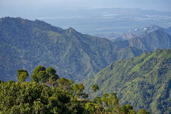
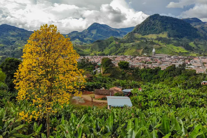
Minca is a small town located in the foothills of the Sierra Nevada de Santa Marta, 650 meters above sea level, and about 14 km from the center of the city of Santa Marta, in the department of Magdalena, northern Colombia.
Brief Intro about Minca
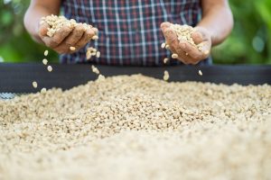
It is considered the ecological capital of the Sierra Nevada de Santa Marta. It is a region with a vocation for coffee, and for many years it attracted inhabitants from the north of Santander who took advantage of its land and climate for the cultivation of coffee.
Coffee Production in Minca, Sierra Nevada de Santa Marta
In the past, it was an area marked by armed conflict. Today it is a safe place. However, in Colombia, and everywhere, it is better not to give papaya. I recommend you not to go out without the accompaniment of a certified guide, especially if you go to the waterfalls or to the hotels outside the city, and at night.
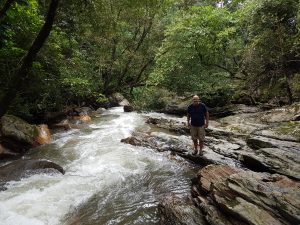
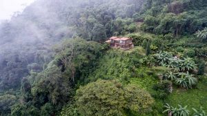
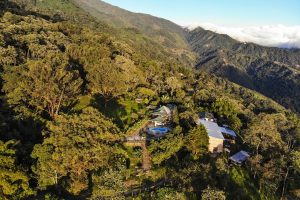
Minca has a rich archaeological history and is an ecological paradise with the crystal clear Minca River and its immense green vegetation.
This place served in the past as a habitat for the Tayrona culture. Today they are found in the indigenous peoples belonging to the Kággaba (Kogi), Ijka (Arhuaco), Wiwa (Arzarios) and Kankuamo in the highlands.
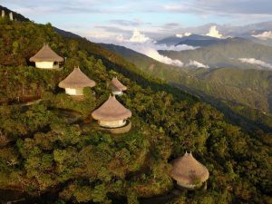
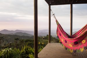
Minca has multiple lodging sites, it is the corner of painters, sculptors and artisans. There are also several coffee producinghaciendas that have opened their doors to tourism.
If you decide to visit Minca, in this blog you will find a travel guide to Minca, learn what to do in Minca, where to stay in Minca and more.
How to get to Minca
No matter where you come from, to get to Minca you will have to get to Santa Marta first.
Once in Santa Marta, you can book a private transfer to Minca from Santa Marta which does offer convenience. Some people prefer to arrive by cab or even by motorcycle.
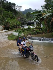
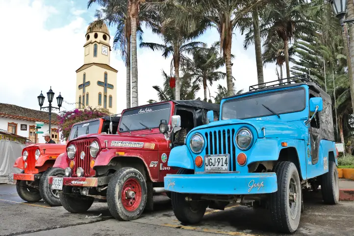
Once in Minca, motorcycle or 4×4 car become the only transportation option, especially in the rainy season which is from October to December and from April to May.
Roads in Minca during rainy season
If you are going to the higher areas, it is necessary to go up by motorcycle or 4×4 car, since the road is not paved, it is narrow, and when it rains it becomes a river of water, and a reservoir of mud. But don’t worry, I promise you that the experience can be really fun!
What you can do in Minca
Thanks to its geographical position, Minca and its surroundings have different attractions.
It is a place where you can enjoy a cooler climate if you come from beach areas like Cartagena or Santa Marta.
There you can do everything related to nature tourism: hiking, mountain biking, bird watching, water tourism in rivers and waterfalls, adventure, rest and coffee.
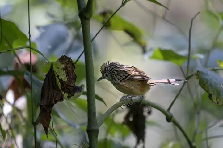
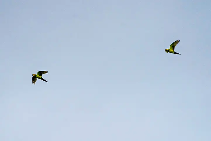
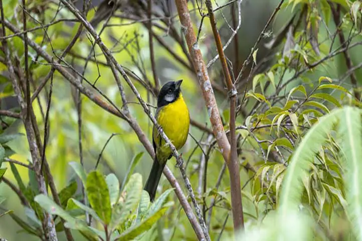
Bird watching
Minca’s altitudinal gradient makes it a very interesting destination for bird watching, also because it is located in the Sierra Nevada de Santa Marta, which is a hotspot of endemism not only for Colombia, but worldwide.
Two hours by car from Mica is the El Dorado Natural Reserve, ideal for observing endemic species of the Sierra Nevada.
In its surroundings there are about 300 species of birds, both resident and migratory. It is a region of coffee plantations, with habitats ranging from dry forest, rain forest, cloud forest, and páramo (moorland) in the higher parts.
W Santa Marta Antbird – Drymophila hellmayri ENDEMIC
Among the most striking species are Santa Marta Brush-finch, Sierra Nevada Brush-finch, Santa Marta Parakeet, Scarlet-fronted Parakeet, Santa Marta Warbler, Santa Marta Foliage-gleaner, Santa Marta Antbird, White-lored Warbler, Santa Marta Tapaculo, Brown-rumped Tapaculo, Whooping Motmot, Golden-winged Sparrow, Santa Marta Emerald Toucanet, White-tipped Quetzal, Santa Marta Blossomcrown, and many others.
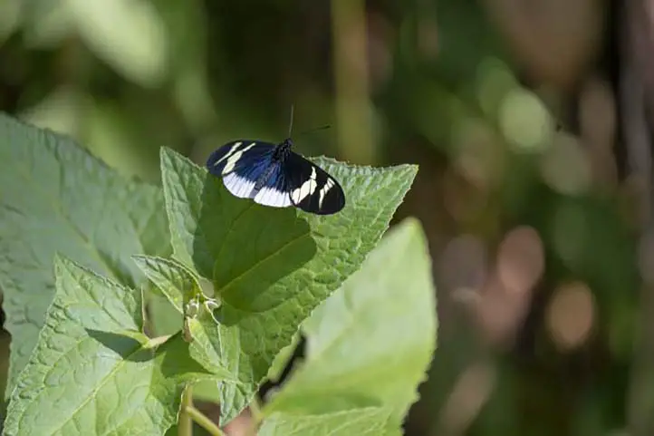
Wildlife Watching
In addition to bird watching you can go on night safaris, especially around El Dorado Natural Reserve.
In Minca you can find the habitat of many species and there is a high concentration of endemic species, not only birds, but also frogs, reptiles, butterflies, plants and beautiful landscapes.
Butterfly watching in Minca, Sierra Nevada de Santa Marta
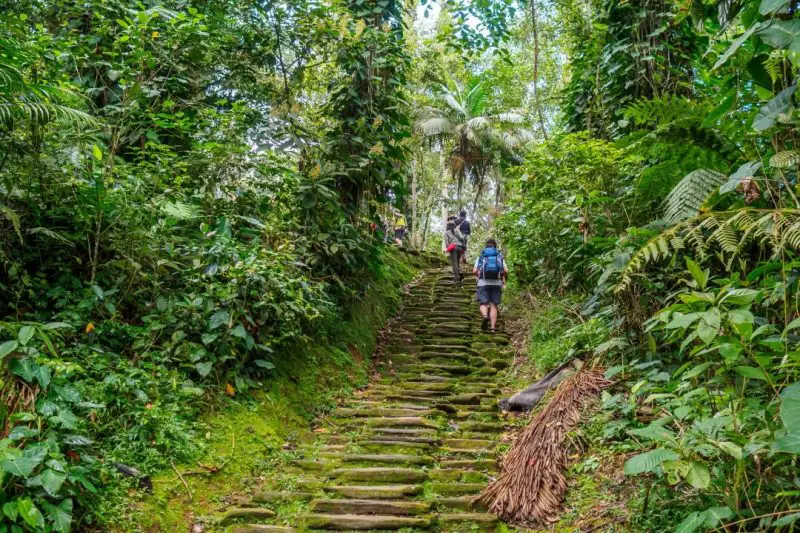
Hiking and Trekking
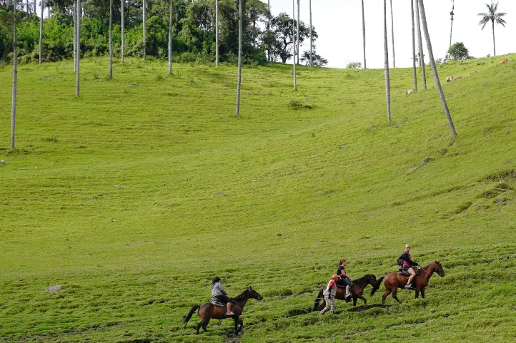
Minca is also an ideal destination for trekking. There are several routes, but among the most recognized are Las Piedras, Los Pinos and Cerro Kennedy.
The most recommended hike is of medium intensity, with one day of duration, and 11 km of route. It begins by leaving Santa Marta by land transport to Finca La Victoria, where you can learn about the process and history of coffee in this region.
From there you will continue walking and getting to know viewpoints and the diversity of bird species until you reach the area of Los pinos, 1,300 meters above sea level. From Los Pinos you will descend to the waterfalls of Marinka, being the final and refreshing point of the tour.
Views of the Sierra Nevada de Santa Marta from Minca
Cerro Kennedy is another good destination for trekking in Minca. Most travelers choose to do this route on foot, but for mountain bike fans, there is a mountain biking route as well as the option to go up by bike.
The hike to Cerro Kennedy is of a moderate to difficult level. It is a 25 km route from Minca, to go and back takes two days. You will go from 650 meters above sea level, to 2700 meters. There you will find fascinating views of the Sierra Nevada de Santa Marta.
Water Tourism
Visiting rivers and waterfalls in Minca
Pozo Azul
After a 45 minute walk from the center of Minca, you will find Pozo Azul, which crosses the Minca River.
Cascades of Marinka
They are found after a walk of 90 minutes from the center of the town. You will have to pay for a small admission fee.
At Marinka you will find two waterfalls, one of them with a natural pool. There are also bathrooms and a café.
Adventure
Cycling or Mountain Biking in Minca
There are many plans and routes in the mountains and around Minca. You will be able to live an incredible adventure full of adrenaline. There are tours from beginners to advanced.
Rappel down waterfalls.
You can practice rappelling in the Marika waterfalls.
Coffee and Beer Experiences
La Victoria Farm
La Victoria was founded in 1892 and is one of the largest and oldest coffee estates in northern Colombia. It is located about a 90 minute walk from the town of Minca.
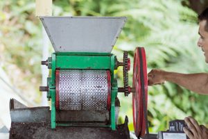
Coffee Production in Minca, Sierra Nevada de Santa Marta
In addition to producing top quality organic coffee, La Victoria is home to Nevada, a small brewery that makes artisanal beer using pure mountain water and local products such as coffee and coca leaves.
La Victoria has also embraced tourism as an alternative source of income, offering guided tours that explain the history and operation of the coffee farm, you can learn the entire process of cultivation and preparation for export, and see their early 20th century machines that run on hydroelectric power.
The farm also has its own nature reserve for the enjoyment of bird watchers and nature lovers.
Where to stay in Minca
Minca has many houses, hostels and farms that offer their guests comfort and tranquility. They are available in all types and prices. Here I will recommend some of the best options:
Current director of Sula. Doctor in Biological Sciences. Her main interests are to explore and understand the organism – environment interactions, taking advantage of emerging knowledge for the management and conservation of species and ecosystem services. She is currently working as a consultant in functional ecology, ecosystem services and conservation projects in Colombia related to ecotourism and birdwatching.
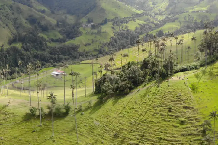
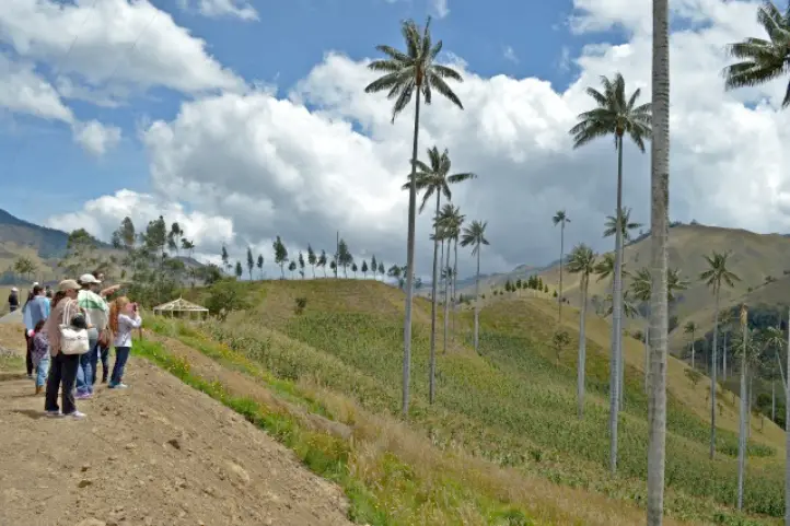
Come to Colombia to meet the outstanding Wax Palm! As we mentioned in a past entry, the Wax Palm, Ceroxylon quindiuense (Karsten) Wendl, is an endangered endemic species of Colombia. It is also the national tree and the star of one of the most beautiful and emblematic landscapes of the Colombian Andes.
Tourism is one of the most promising conservation strategies for this species. On the other hand, rural communities prefer it over agriculture, livestock, and mining.
Today there are all-terrain trucks that travel through areas such as Toche. There are even bicycle tours that take you to remote farms so you can enjoy the spectacular landscapes of the cloud forest with wax palms while descending to Toche or Salento.
Where to see Wax Palm Forests in Colombia
Salento and Valle de Cocora
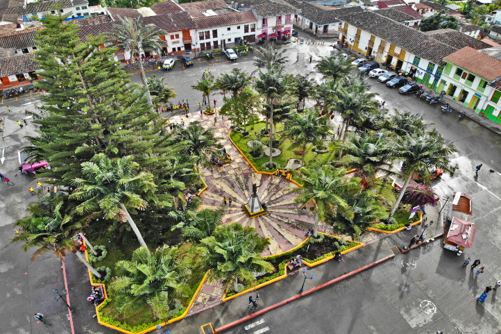
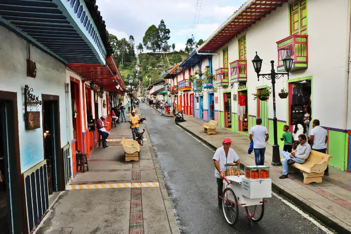
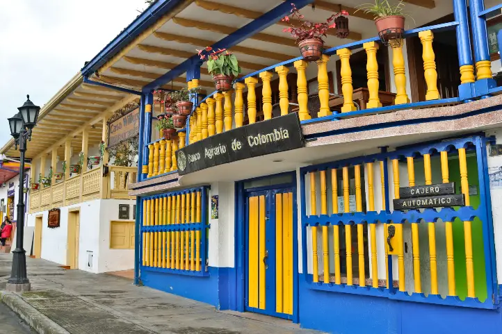
The municipality of Salento is the cradle of the national tree, the Wax Palm, and has a great variety of tourist attractions. Salento is the oldest municipality of Quindío and the oldest among the three main departments that make part of the Coffee Triangle (Caldas, Risaralda, and Quindío). It is a beautiful town, interesting for its typical crafts and its streets full of color and history.
Bolívar Square – Salento, Quindío
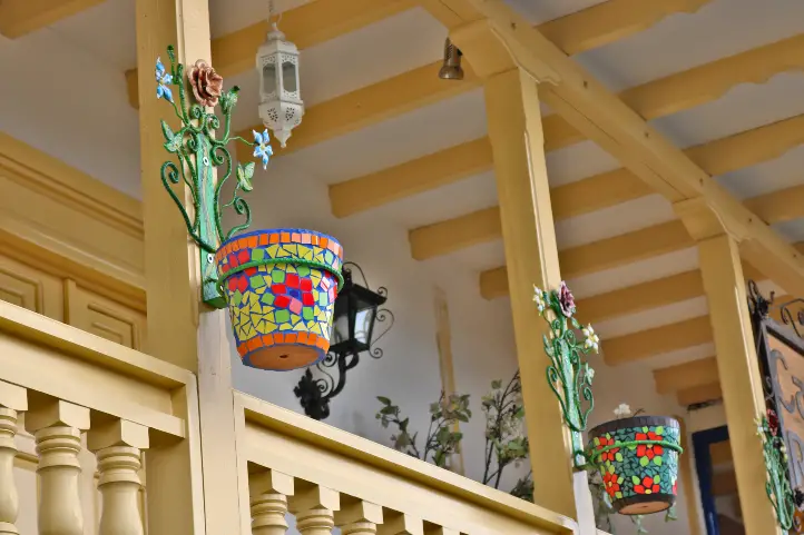
Walking around the town will help you get to know the architecture typical of the Antioquian colonization, in which mud and adobe houses predominate, with colorful gates made of wood, and windows and balconies full of flowers.
Colorful Streets of Salento
Colonial Balconies full of Flowers in Salento
Colonial Architecture of Salento
The best days to visit Salento are during the week, since there are fewer visitors. You will find a varied offer of accommodation among luxury hotels, hostels, camping areas, and glamping.
What to do in Salento
Among its most important attractions are:
The Cocora Valley
The National Natural Park Los Nevados
The Traditional Architecture of the Colonization
The Bolivar Square
The Royal Street
The Church of Nuestra Señora del Carmen
The Ecoparque El Mirador and Alto de la Cruz
The Artisan’s Village
The Bridge of the Explanation “El Amparo”
A Coffee Tour
The Agro-ecological Park “The Promised Land”
COVID-19 update: most of the restaurants, stores, and tourist sites in Salento have already opened their doors again. However, the increase in cases of coronavirus has caused the Mayor’s Office to consider regulating the entry of visitors.
Thousands of tourists travel every year to the Cocora Valley, in the coffee region of Colombia, to admire its impressive palms.
What to do in Cocora Valley
Here you can enjoy the sighting of one of the most beautiful landscapes of Colombia while having a delicious cup of coffee at the Mirador Aires de Cocora. In this place, you can enjoy not only coffee but also delicacies such as passion fruit, cakes, desserts, and sweets to brighten up the afternoon in the company of your family or friends.
Besides drinking coffee, you can go on a guided horseback ride through the valley and take pictures of the monumental landscapes. Quindío and the Cocora Valley are unique places in the world that deserve to be known, preserved, and admired by all.
Guided horseback ride through the Cocora Valley
But even in this region, the wax palms are scarce. The fact that much of the surrounding forest has been cut down to make way for cattle grazing is part of the reason for their scarcity and, in turn, their threat.
So, if you want to know a real wax palm forest and see the landscape that amazed both explorers, travelers and naturalists, as Mutis and Humboldt, from the eighteenth century to today, I recommend the following destinations below.
86% of the wax palm forests are found in Toche, being the largest wax palm forest in Colombia and the world, with around 600.000 individuals!
86% of the wax palm forests are found in Toche, Tolima
Toche is a small village hidden between mountains and fog. It is no longer one of the areas of Tolima most affected by the armed conflict. The armed conflict took this region out of the hands of deforestation, and that is why there are very well-preserved high Andean forests.
Today it is a beautiful example of the community’s effort to position this place as a tourist destination of choice.
How to Arrive to Toche
Toche can be reached from Salento, Quindío, by an open road that crosses a moorland area, and gives you the most spectacular views of the cloud forest with wax palms that you can’t even imagine.
You can also arrive from Tolima, from the municipality of Cajamarca. From there you will have to go up to Toche on a very difficult road. It is only possible to go by off-road transport, to make sure you don’t get stuck on the way. This road is also very difficult due to the constant landslides on the mountain slopes.
In Toche you have to visit the Cerro Machín Volcano. This is an active volcano, one of the most dangerous in the world. You can walk to its top, while you find hot springs and clouds of gases released to the surface through mini-craters. You can also walk over the main crater of the volcano, which looks like a swampy area, where you can also observe birds and a forest with wax palms around it.
In Toche, you can also take ecological walks, visit and enjoy hot springs, and do bird watching, especially the yellow-eared parrot.
There are other regions in Colombia where you can find wax palm forests. These are mainly in Caldas, Quindío, Tolima, and Valle del Cauca. However, here I will tell you the most appropriate ones to visit.
You can even find wax palms in cities like Bogota, or Armenia, at the Quindío Botanical Garden. To know more read our entry The Wax Palm and Why it is a Must to See When Visiting Colombia.
San Félix – Caldas
In San Felix is the Samaria Forest, a forest of wax palms. San Felix is a village located at 2,823 meters above sea level in the north of the department of Caldas, 25 km from its municipal capital Salamina and 96.3 km from the capital of Caldas Manizales. Its climate is cold, with an average temperature of 14°C and the temperatures in the early summer go up to 0°C.
It is called “The Paradise of the North”, a name that is due to its landscapes of unparalleled beauty. It has a natural forest of wax palms to which you will arrive by jeep. There you will be received by the peasant community, hard-working, humble, simple, and committed to the region. You will enjoy typical dishes and a guided walk-through path surrounded by wax palms.
The jeep is the car par excellence to move around the Colombian coffee axis.
Tourism is very important as an economic alternative for the cultivation of Hass avocados in this region. This crop is devastating hectares of forest and destroying the habitat of the wax palm in this region.
The Yellow-Eared Parrot Reserve was established by Proaves Foundation in order to guarantee the survival and promote conservation actions aimed at the populations of Yellow-Eared Parrot (Ognorhynchus icterotis) and Wax Palm (Ceroxylon quindiuense), in the areas of Jardín (Antioquia) and Riosucio (Caldas) in Colombia.
Jardín, Antioquia
The Reserve is located in the village of Ventanas, one hour from the town of Jardin (Antioquia), on the road that connects this municipality with Riosucio, Caldas. It has an extension of 188 hectares and presents altitudes ranging from 1,900 to 2,600 meters above sea level. It is classified by the Alliance for Zero Extinction as an AZE site.
Yellow-eared Parrot
This place is the only wax palm sanctuary established in Colombia, but its main goal is to protect the endangered Yellow-eared parrot, a species that nests in the trunks of the wax palm.
According to María José Sanín, a botanist at the CES University in Medellín, the problem is that the palms must be dead since that population of palms is old and is dying massively, which is good for parrots and birders, but terrible for the palms.
What to do in the Reserve
In the Reserve, you can go hiking and bird watching. There are also hummingbird watering places, where the Inca Collared comes.
Current director of Sula. Doctor in Biological Sciences. Her main interests are to explore and understand the organism – environment interactions, taking advantage of emerging knowledge for the management and conservation of species and ecosystem services. She is currently working as a consultant in functional ecology, ecosystem services and conservation projects in Colombia related to ecotourism and birdwatching.
The lakes of Colombia are not lakes proper. Due to its extension, the water deposits of the Andean mountains are only lagoons. The largest are: Lake Tota, located at 3,115 meters above sea level in Boyacá, and Lake La Cocha, at 2,660 meters above sea level in Nariño. In Cundinamarca there is the Lake Fúquene and others of great importance Like the Suesca and Guatavita lagoons.
But don’t get confused! In Spanish lago (lake) and laguna(lagoon) definitions are not the same as in English.
In Spanish, a lake refers to a body of water that has an entrance and an outlet of rainwater, groundwater, and/or rivers, for example, the Lake Michigan or the Lake Superior in the USA, or the Lake Tota in Colombia. A lagoon, on the other hand, is a body of standing water that has an inlet from rivers or streams, but no outlet, for example the Great Salt Lake in the USA, the Caspian Sea in Asia, the Lake Corangamite in Australia, the Laacher See in Germany, and Lake Titicaca in Bolivia.
Now, in English, the difference between a lake and a lagoon, as well as its definition, is quite different. Lagoon is defined as a type of saltwater lake that is formed by the waves of the ocean. Also, lagoon is close to the ocean, whereas lakes are far away from oceans.Lagoon is saltwater body, whereas lakes are mostly freshwater bodies. Lagoons are generally shallow compared to lakes. And so on…
For an equal understanding, this is what you may call an exorheic and an endorheic basins, i.e. open and closed lakes respectively. And, translating to Spanish, lakes are exorheic and lagoons are endorheic basins. If you arrived here because of a homework about lakes visit National Geographic Encyclopedia about lakes. So… what is this post about?
Lagoon. In Spanish, a lagoon is a body of standing water that has an inlet from rivers or streams, but no outlet.
Lake. In Spanish it means a body of water that has an entrance and an outlet of rainwater, groundwater, and/or rivers.
Ok. This post is about the lakes of Colombia you can visit for fun and enjoy nature. Lakes of Colombia are also known, and called, as “lagunas” (lagoons), but they are not like the lagoons you are used to know. So, don’t get confused, when you visit a “lagoon” in Colombia, it will be, for sure, very far from the coastal zone, and it will be a freshwater lagoon, as you may have already noticed. And it can be lake… or not… geez!
In parentheses you will find the real type of water body that each lake or lagoon belongs to, according to the definition in Spanish.
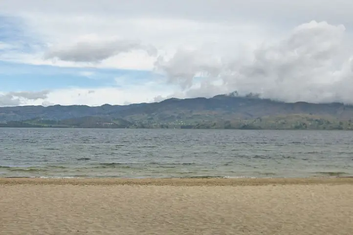
Exorheic Basin. With an area of nearly 55 km², it is the largest lake in Colombia and, after Titicaca, the second highest navigable lake in South America at 3,015 meters above sea level (9891.7 Ft.).
In the southwestern part of the lake, there is a natural bay called Bahía Blanca. It is frequented by bathers and water sports enthusiasts despite the low temperature that usually does not exceed 12 °C.
What to do
Despite the stories about the Tota Lagoon monster(Diabloballena), as terrifying as the Loch Ness monster (Nessie) in Scotland, today you can practice water sports, sportfishing, navigate the lake, walk through the forest, camp and enjoy Playa Blanca, the only cold-weather beach in Colombia.
When sailing you can visit the islands of the lagoon: El Sagrario de los Milagros, San Pedro, Cerro Chino, Santo Domingo, Isla del Amor and La Ballena.
Laguna de La Cocha
(La Cocha Lagoon, exorheic)
Location
Characteristics
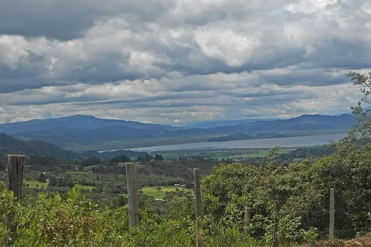
Lake La Cocha, also called Lake Guamués, is a natural lagoon of glacial origin, located in El Encano, a village in the municipality of Pasto, in the department of Nariño. With an area of nearly 40,5 km², it is the second largest natural body of water in Colombia, after the Laguna de Tota. It is located at 2680 meters above sea level (8792.6 ft.)
In 2000, Colombia registered the La Cocha lagoon, or Guamués lake, as a wetland of national and international importance within the Ramsar Convention, being the first with this qualification in the Colombian Andean region.
What to do
In this place it is possible to take boat trips, do sport fishing and bird watching.
Inside the lagoon there is the smallest flora sanctuary of Colombia, the Isla de la Corota Flora Sanctuary, with 15.2 hectares. It is located in the north of the Laguna de la Cocha. It is considered as a source of sacred energy for the indigenous and traditional doctors of the region. Likewise, it has a chapel that is an important pilgrimage site for Catholics, especially during the Virgen de Lourdes Festival. There you can walk trails designed to observe the forest.
Laguna de Guatavita
(Guatavita Lagoon, endorheic)
Location
Characteristics
This is the most famous sacred lake among our pre-Hispanic ancestors. The legend of El Dorado derives from it, a story that brought many people crazy about its relentless thirst for gold and wealth. The lake has suffered failed drainage attempts, made by these crazy treasure hunters.
It is located in the eastern mountain range of Colombia, at an altitude of 3,100 meters above sea level (10170.6 ft.) and has a temperature of 5 to 11℃. the lagoon has a maximum width of 0.7 km, a surface area of 19.8 hectares and an average depth of 125 m. It is supplied mainly by groundwater. It was formed in a perfectly circular mountain depression, surrounded by native forests. There are several hypotheses about its formation: by a meteorite, by a collapse caused by the dissolution of saline strata, or by glacial action and erosion. Today it has reached a stage of sedimentation.
What to do
Its environmental recovery has allowed that, after many years, activities can be carried out such as hiking, and landscaping.
Laguna de Fúquene
(Lake Fúquene, exorheic)
Laguna de Fúquene. Picture by Francy Ramírez
Location
Characteristics
With an area of 30 km² and located at an altitude of 2540 meters above sea level (8333.3 ft.), the Fúquene lake has numerous islands, one of which was a sanctuary for the Muiscas. According to the legend, hidden under the waters and ready to defend his domains in the valley of Ubaté and Chiquinquirá, remains Fu, a god-demon with the head and tail of a fox and human body. His name in Chibcha is decomposed from “Fu” which means fox, and “quene” which means bed, which would be translated as the bed of the fox.
The local community depends directly on the lagoon, since it is a source of water for domestic, agricultural and industrial activities. It is also the habitat of several migratory and endemic species.
What to do
Its environmental recovery has allowed that, after 40 years, nautical activities can be carried out with small boats such as sailboats, kayaks and rowing surf.
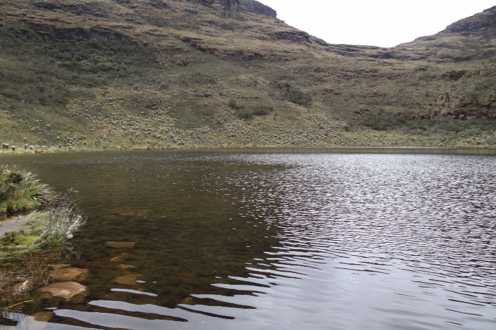
The Otún lagoon is one of the highlights of the Los Nevados National Natural Park. This lake measures about 1.5square kilometers and is located at 3,950 meters above sea level (12959.32 ft.) in páramo ecosystem, being perhaps one of the highest that you can visit. Formed by volcanic and glacial action, it is fed mainly by the snowmelt of the Nevado de Santa Isabel. It is one of the most beautiful ecological hiking destinations in Colombia. It is located in the department of Risaralda, Colombia. Its waters seep under caverns formed by volcanic flows and give rise, together with Laguna La Leona, to the Otún River, which is the source for the aqueduct of the city of Pereira.
What to do
This lake is a great tourist attraction in Risaralda for its great beauty and for trout fishing. The trout is a species introduced to the lake. In the lake you can see the Ruddy Duck (Oxyura jamaicensis), owls and hummingbirds, while the landscape is dominated by frailejones (Espeletia sp.) and typical páramo grasslands. Besides fishing, you can also camp there.
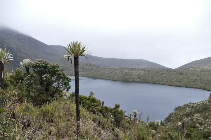
The Iguaque lagoon is located near the municipality of Villa de Leyva in the department of Boyacá, Colombia. It has an area of 6.75 km² and an average depth of 105 m. It is located at 3,800 meters above sea level (12467.19 ft.) in the páramo ecosystem, with a temperature from 4 to 12ºC on average.
According to the Muisca legend, the goddess Bachué came out of the lagoon with a child, giving rise to the entire human race. Bachue is the “Good Woman” mother goddess of the Muiscas.
What to do
Visiting this sacred lagoon is believed to cleanse the soul and purify the spirit. The lagoon is protected as part of the Iguaque Fauna and Flora Sanctuary. There you can go hiking, go on scientific and research tours, observe fauna and flora, observe the cultural heritage, and enjoy the landscape.
The Laguna de Sonso or del Chircal, was decreed as a Natural Reserve since 1978 and regulated for the use of land, water and airspace in 1979.
It is located on the right bank of the Cauca River, between the municipalities of Buga, Yotoco and Guacarí, in the department of Valle dal Cauca. It has an area of 2,045 hectares, (covering 14 square kilometers of these municipalities), of which 745 correspond to the lagoon zone and 1,300 to the buffer zone. It is located 936 meters above sea level, with an average temperature of 23ºC, and a relative humidity of 75%, being an attractive space for various species.
What to do
The Lake Sonso is part of the RAMSAR international agreement signed on February 2, 2017. It has a perfect combination of aquatic birds and dry forest. In addition, it is a refuge for migratory and endemic bird species, totaling more than 300 species. For this reason the main tourist activity in the Sonso lagoon is bird watching and bird photography.
Lagoons at Natural National Park Chingaza
(Lakes of Chingaza, exorheic)
Lakes of Chingaza National Natural Park
Location
Characteristics
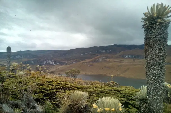
The beautiful Chingaza National Natural Park is located in the eastern Andean mountain range of Colombia, between 3,050 and 3,950 meter above sea level (9858.924 – 12959.32 ft.). It has a great water richness constituted by the upper basin of several rivers, as well as by a lagoon system which has been declared a Ramsar site.
The Lacustrine system of Chingaza is formed by 20 lagoons and wetlands that supply water to the capital city, Bogotá. It is also of great importance for migratory birds.
Among all the lagoons, the largest is the Chingaza lagoon, with an area of 88 hectares, which contributes a high percentage to feeding the aqueduct that provides water to the city of Bogotá.
What to do
Four of the 6 trails enabled for ecotourism in the Chingaza park are to visit different lagoons:
You can do guided mountaineering in the modality of “hiking without camping” towards the lagoons. You can also contemplate the landscapes of lagoons, wetlands and streams, as well as observe the flora and fauna of the páramo.
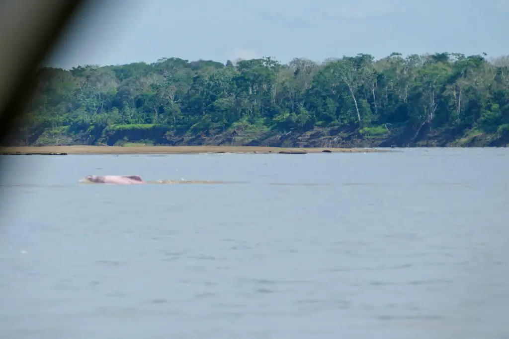
Lakes of Tarapoto
(Lakes of Tarapoto, exorheic)
Amazon river dolphin (Inia geoffrensis), at Puerto Nariño, Amazonas department, Colombia.
Location
Characteristics
It is located in the municipalities of Puerto Nariño and Leticia, department of Amazonas. The lakes of Tarapoto are a strategic ecosystem made up of more than 30 interconnected lakes, which reach an approximate area of 11,424 m2 in periods of low water. According to Ramsar.org, this ecosystem:
“provides important functions such as flood and erosion control, waterways for transportation, recreation and tourism.”
Besides being one of the greatest ecotourism attractions in the region, this biome is the means of subsistence and food for 22 indigenous communities, Cocama, Ticuna and Yagua, which are part of the Ticoya reservation in the Amazon.
It has been declared a Ramsar area in 2018, thanks to the joint work between the inhabitants of Puerto Nariño, the indigenous people of the Ticoya reservation, the Omacha Foundation, the Colombian government, Corpoamazonía, the Sinchi Institute and the World Wide Fund for Nature (WWF).
What to do
There you can arrive by boat and wait in silence for the appearance of pink dolphins, while contemplating the majesty of the Amazon jungle.
Lagoons at Natural National Park Sumapaz
(Lakes of Sumapaz, exorheic)
Páramo of Sumapaz
Location
Characteristics
Bogotá has the largest and most beautiful páramo in the world, the Páramo of Sumapaz. This ancestral place was considered by the Muiscas as the habitat of the gods.
Here you can enjoy unique landscapes, unique animals and the particular vegetation of an ecosystem that is dedicated to safeguarding water: the páramo.
What to do
In the Sumapaz páramo you can visit the following lagoons:
Alar Pasquilla Lagoon
According to the District Tourism Institute of Bogotá, the Alar Pasquilla lagoon is one of the seven wonders of the city. This sanctuary full of frailejones, imposing cliffs and a 3,200-meter-high viewpoint is a unique plan.
Negra lagoon
This body of water has been the object of legends, which is why it can be considered the most mysterious lagoon in the páramo of Sumapaz. In pre-Columbian times, when the Zaque de Hunza (Tunja) and the Zipa de Bacatá (Bogotá) were at war, it was known as the Saguanmachica lagoon, because a zipa with that name was crowned there.
Los Colorados Lagoon
Also known as the enchanted lagoon, this paradise is a place that few know because of its difficult access.
Los Tunjos
They are the best known bodies of water in Sumapaz because it is easy to get to them. This area has a forbidden route, where you can see lagoons and cliffs as high as the Colpatria building.
Larga Lagoon
In this lagoon of the Sumapaz National Natural Park it is common to see fish, wild ducks and other types of birds. Access is very easy, because it is close to the Los Tunjos complex.
Laguna Cajitas lagoon
This body of water at 3,850 meters high is famous because the Black-chested Buzzard-eagel can be seen frequently. The best panoramic view of the lagoon is on Cerro La Carolina, a difficult place to access because you have to climb for about an hour.
Laguna de Cumbal
(Lake Cumbal, exorheic)
Location
Characteristics
The Cumbal lagoon, also called La Bolsa lagoon, is located at the foot of the Cumbal volcano, at 3440 meters above sea level (11286.09 ft), in the department of Nariño, south of Colombia.
This lagoon is characterized by the gray color of its waters, the very low temperature and the absence of waves. The Cumbal lagoon basin is small in size (9.8 km²) and is located in a very sensitive aquifer recharge zone.
It is a sacred place for the indigenous people of the region, who belong to the grasslands ethnic group, and according to them, humanity originated there. For this you infer this place is of feminine energy, and it recalls the uterus of a woman, that is why it is called the bag.
What to do
You will be able to enjoy a majestic landscape of mountains, valleys, nearby volcanoes and see the snow-capped mountains of the Republic of Ecuador.
You can also do sport fishing activities, since the rainbow trout abounds in its waters. You can also meet the indigenous inhabitants of the area, their culture, traditions and gastronomy.
Recommendations
To enjoy it to the fullest, we recommend you take comfortable, warm and waterproof clothing. You should also wear mountaineering boots that are waterproof. In some places you may be short of breath due to the altitude, in that case, breathe deeply and slowly, and walk at your own pace. There will always be people watching over you and taking care of you so that you get the best experience.
If you want to know more about Colombian nature tours, or want to visit any Lake of Colombia, follow us, write us comments, or just contact us.
Rutas de los Andes Blog https://rutasdelosandes.com/
Wikipedia
WikiAves de Colombia
Colombia Travel
Colparques Website
National Natural Parks of Colombia Website
Ramsar.org
Semana Journal
About the author
Sara Colmenares
Current director of Sula. Doctor in Biological Sciences. Her main interests are to explore and understand the organism – environment interactions, taking advantage of emerging knowledge for the management and conservation of species and ecosystem services. She is currently working as a consultant in functional ecology, ecosystem services and conservation projects in Colombia related to ecotourism and birdwatching.
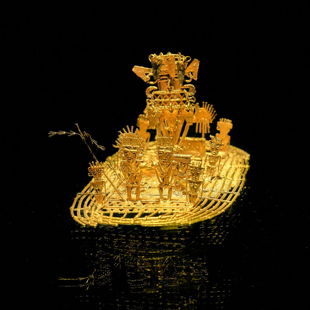
The Guatavita lagoon was one of the most sacred of the Muiscas, since the ritual of investiture of the new Zipa (Cacique- chief) was carried out there. This is one of the origins of the El Dorado Legend. The famous Muisca Raft that is exhibited in the Gold Museum of the Bank of the Republic of Colombia is evidence that this type of ritual was celebrated in the lakes of the region. Find out more about the museums of Colombia in The 117 Museums Guide of Colombia for Culture Travelers travel guide.
Guatavita comes from the Chibcha language GUA-TA-VITA, which translated into Spanish means “tillage of the tip” or “end of the mountain range”, as stated by the linguist Joaquín Acosta Ortegón in his Chibcha dictionary. The Chronicler Fray Pedro Simón, in his “Historical News”, said that Guatavita was called Guatafita, which means “thing set on high”, stating that it was the Spaniards who made the change from F to V to give it more phonetic sweetness to that name.
Origins of El Dorado Legend
According to the Muisca tradition, in Guatavita the cacique Sua was married to a beautiful princess from another tribe. Sua was very fond of chicha and bacchanals, and his wife, with whom he had a daughter, fell in love with a warrior who was courting her.
The lovers were caught by Sua, and he subjected the warrior to horrendous tortures, to the point of taking his heart out and serving it to his wife. The woman fled in despair, took her daughter in her arms and dove with her into the lagoon.
The cacique ordered the priests to recover his family. They informed him that the woman was now living under water, where a large snake had betrothed her. The cacique demanded that his daughter be brought to him, and they brought him a child without eyes. Sua, disheartened, returned her to the waters and ordered that from that day on, the best emeralds and gold filigrees be thrown into the lagoon (if you want to know about filigrees watch our video Santa Fe de Antioquia). The purpose of the ceremony was to beg the queen to ask the gods for prosperity and bonanza for her people.
Every full moon, Guatavita’s snake emerged from the waters to remind the people about the offerings, the priests watched his appearance as a sign of prosperity.
The Golden Indigenous
El Dorado Legend, gold statue at the Gold Museum, Bogotá, Colombia, picture by Pedro Szekely, from flickr, CC BY-SA 2.0. Wikimedia.
With the Spanish invasion, the ritual acquired a new meaning. They were told that a ritual was carried out when a new cacique, usually the nephew, son of a sister of the previous cacique, was in power.
The heir prepared himself within a six years period before the ceremony. He had to purified himself through fasting, and confined himself in a cave where he could not see the sun or eat food with salt or chili.
Some chroniclers have narrated it this way:
“…In that Guatavita lagoon, a great raft of reeds was made, decorated as brightly as possible… They undressed the successor, smeared him with a sticky soil and sprinkled him with gold powder and ground, so that in the raft everything was covered with this metal…
The golden indigenous man made his offering by pouring all the gold and emeralds he carried into the middle of the lagoon, and the four chiefs who went with him did the same. During the way back to land in the raft, they started a party, with bagpipes and “fotutos”, with dances in their own way, with which ceremony they received the new cacique who was recognized as lord and prince …”
From this ceremony was taken that so celebrated name of El Dorado.
The Search for the Treasure
The history of the “golden indigenous” gave rise to the “El Dorado”, a mythical place that the conquistadors sought from the Andes to the Amazon, with such eagerness that within a week, in 1539, three expeditions led by Sebastián de Belalcázar, Nicolás de Federmán and Gonzalo Jiménez de Quesada, from Peru, Venezuela and Santa Marta, respectively, coincided in Guatavita.
There were several attempts to drain the lagoon to find its hidden treasures, among which the most important were that of Captain Lázaro Fonte, who was able to extract several pieces of fine gold, and that of Antonio de Sepúlveda in the 16th century, who also managed to remove emeralds and ceramic pieces.
In 1580, a merchant named Juan Sepulveda employed 5,000 indigenous men and dug a canal to drain it. The water level dropped as much as 20 meters, but then the canal collapsed and the King of Spain refused to continue financing the enterprise. Sepulveda had to abandon, despite having rescued several pieces of filigree and an emerald the size of a fist.
Unsuccessful attempts continued throughout the colony, but the legendary gold continues to fuel treasure hunters’ dreams to this day. In an old German book published in 1911, for example, there is even a photograph, supposedly real, of the totally drained lagoon.
In the book is narrated that some W. Cooper, representative of the English company Contractors Limited, had shown two German tourists photographs of objects taken from the lagoon as rings, snakes, frogs and men’s heads, made of gold. This Cooper told them that the value of the gold found since 1909 amounted to at least 500 pounds, which paid several times the investment of the expedition.
Recovery of Guatavita Lagoon
What is certain is that the Guatavita lagoon, when you visit it for the first time, is smaller than you could imagine… given the size of the legend!. But the sad thing is that this happened after it was emptied of more than half its contents by gold diggers, English and Germans, among others, until the end of the 19th century. These treasure hunters opened a hole in the mountain to drain the water to take out the gold pieces that rested at the bottom of the lagoon.
Fortunately, the failure of all these expeditions appeased the greed of the gold diggers. Initially, the place was reduced to abandonment, and at the beginning of the 21st century the park was closed to the public to try to recover it.
Today, a good part of its splendor has been reborn, with the frailejones, bromeliads, lichens, arnicas and multicolored mosses. The true treasure is the lagoon and the páramos of Colombia, because from there the water flows to all the surrounding regions.
Currently, the lagoon is located in an environmentally protected area where you can access a trail that crosses an impressive mountainous area, full of vegetation and typical species of the Colombian páramo.
We recommend you to visit the Guatavita Lagoon after visiting the Golden Museum in Bogotá.
How to Get to Guatavita Lagoon
Guatavita town is located 75 kilometers northeast of Bogotá, bordering the municipalities of Sesquilé and Machetá to the north; Gachetá and Junín to the east; Guasca and Sopó to the south; and Tocancipá and Gachancipá to the west.
However, Guatavita Lagoon is 8 km from the road that borders the Tominé reservoir, besides the town.
The Guatavita lagoon today is a Regional Natural Reserve of the System of Protected areas of Colombia. Entrance fee for foreigners is around of 13,000 COP (3.5 USD). After paying, you will be led by a local specialized guide, in small groups, through a natural path along the paramo.
Local guides are from the Muisca community which still inhabits the region.
Accomodation near Guatavita Lagoon
You can find accommodation in the town of Guatavita or in the nearby parks associated with the reservoir circuit that exist throughout the region. This accommodation, offered by the parks, is of the shared cabin type, with a minimum cost of 215,000 COP (60 USD), depending on the number of people.
Recommendations
To enjoy it to the fullest, we recommend you take comfortable, warm and waterproof clothing, as the average temperature of the place is 13ºC and rainfall is frequent. However, none of this will prevent you from having a deep connection with nature and with the ancestral past that this lagoon hides, and that makes it an authentic cultural heritage of the country.
If you want to know more about Colombian nature tours, or want to visit Guatavita Lagoon, follow us, write us comments, or just contact us.
Current director of Sula. Doctor in Biological Sciences. Her main interests are to explore and understand the organism – environment interactions, taking advantage of emerging knowledge for the management and conservation of species and ecosystem services. She is currently working as a consultant in functional ecology, ecosystem services and conservation projects in Colombia related to ecotourism and birdwatching.
Precious glaciers, snow-capped peaks and paramo ecosystems are some of the jewels to find at El Cocuy National Natural Park in northeastern Colombia. Mountain climbers and nature lovers will love paying a visit to this huge mountain range that is a water producer and biodiversity haven.
In this post, you will find all the information you need to know to visit El Cocuy National Natural Park in Colombia, such as how to get there, what you can do in the park, where to stay, how much it costs and some recommendations for your trip.
Discovering El Cocuy National Natural Park
Colombia has lost 63% of its glaciers in 50 years, according to IDEAM.This means there will be no glaciers in the country in some years if the trend continues. Meanwhile, the Eastern Andes is the privileged home to the largest glacier mass in Colombia: The Sierra Nevada de Güicán, El Cocuy and Chita.
In an area of 25 km long by 4 km wide, about 25 snow-capped peaksstand out on the top of two mountain ranges! The peaks go from 4,800 m (15,748 ft) to 5,330 m (17,486 ft) above sea level, and the renowned ones are Ritacuba Blanco, Pan de Azúcar, Pulpito del Diablo, Cóncavosand Güicán. The temperatures in the park range between 0 °C (32 °F) and 20 °C (68 °F) with a characteristic cold climate.
El Cocuy National Park preserves ecosystems such as glaciers and paramos, as well as high Andean forests – seen in the valleys among the imposing mountains, and moist forests found in the Araucan foothills. Unfortunately, the climate change, livestock breeding and forest clearance (logging) are putting pressure on the protected area.
This marvelous park is guarded by the U’wa indigenous peoples. These have traditionally inhabited the Eastern Andes range and now fight for the conservation of their sacred territory and culture. Fun fact: U’wa means ‘smart people who know how to talk’.
El Cocuy – with its 306,000 hectares, is one of the National Natural Parksopen for ecotourism in Colombia. All of them offer unique experiences in the world’s second-most biodiverse country!
How to get to El Cocuy NNP
There are three land routes to access the tourist area on the western side of the park:
From Bogotá
440 km – approx. 11 hours following the route Tunja–Duitama – Santa Rosa–Cerinza–Belén – Susacón, until reaching Soatá. From there, you can follow the Tipacoque or the Boavita routes that lead to El Cocuy or Güicán.
From Bucaramanga
8 to 12 hours. Get to the town of Málaga, then to Capitanejo–El Espino–Panqueba and finally El Cocuy or Güicán.
From Llanos Orientales
10 to 12 hours on the routeYopal–Sogamoso–Duitama–Belén–Soatá and from there, El Cocuy or Güicán. Or 8 hours on the route Tame, Sácama, Chita until El Cocuy.
From El Cocuy and Güicán, it takes about 2 hours to get to the main entrances of the park on unpaved roads, in regular condition, suitable only for campers and 4×4 vehicles.You can get by a private car, a shared taxi or public trucks that leave from El Cocuy square every morning. The 3 access points areValle de Lagunillas (on the south), Hacienda la Esperanza (at the center) and Ritakuwas (on the north).
What to do in El Cocuy National Natural Park
Hiking and Trekking
Hiking is the most exciting activityinEl Cocuy Park. You can hike only until the glacier edge along 3 trails: Ritacuba, Laguna Grande de la Sierra and Lagunillas – El Pulpito del Diablo.This activity allows you to admire majestic landscapes with Frailejones, imposing mountains and crystalline water bodies.
Ritacuba Trail goes from the height of 4,000 m (13,123 ft) to the glacier edge of the peak called Ritacuba Blanco. The round trip is about 13.8 km.
Lagunillas – El Pulpito Trail goes from 4,000 m (13,123 ft), starting just above the cabin Sisuma and ends in the glacier edge of the Pulpito del Diablo peak.
Laguna Grande de la Sierra Trail starts in a place known as Cuchumba and ends in the glacier edge of the Cóncavosnow-capped peak. This is the longest and hardest trail (21 km/13 mi).
Expert mountaineers can do rock and snow climbing as well as high mountain trekking.
There used to be multi-day treks in El Cocuy, but negative environmental impacts caused by tourists and concerned indigenous inhabitants resulted in the closing of various hiking trails. Now you can only do one-day hikes.
Lagoons
At different points in the park, you can gaze at 25 stunning lagoons including Laguna de la Plaza – which drains in the shape of a waterfall, and Laguna Grande de los Verdes – which stands out for its flashy color.
Wildlife observation
Along the trails, you may spot white-tailed deer, tapirs, the endemic lizard Stenocercuslache and the double-banded false coral snake (Erythrolamprusbizona). The cougar also inhabits the park but it is quite difficult to find.
Birdwatching
El Cocuy Park is an Important Bird and Biodiversity (IBA) which means it is a key spot for bird conservation. Some of the species that inhabit the area are the Andean condor, the endangered Northern Helmeted Curassow (Pauxipauxi) and the hummingbird Shining sunbeam (Aglaeactiscupripennis).
Where to stay in El CocuyNational Park
Staying in El Cocuy NNP is not allowed. However, you can find cabins managed by locals at the starting points of the hiking trails. They offer accommodation and meals.
Best time to visit El Cocuy National Park
The dry season occurs from December to late January, but this is also a peak season for national tourists so the park or the tourist services may be crowded.
El Cocuy NNP Entrancefees
The entrance fee to El CocuyNational Natural Park varies depending on the nationality and age of the visitors. These are the entrance fees for 2020:
Colombians, resident foreigners and tourists from Bolivia, Ecuador and Peru (ages 5 to 25): COP 21,000
Colombians, resident foreigners and tourists from Bolivia, Ecuador and Peru (over 25 years old): COP 36,000
Non-resident foreigners (over 5 years old): COP 73,500
Children under 5 years old and Colombians over 65 years old have free entrance presenting their IDs.
What you should consider when you visit El CocuyNational Park
You must purchase an all-risk policyfor entering and staying in the park.
You must make your reservation and payment one month in advance.
You must register and attend the introductory talk at the registration offices in El Cocuy or Güicán before entering the park. Here you can hire your local guide.
The entrance to the park is from 5:00 a.m. to 9:00 a.m. and return is from 1:00 p.m. to 6:00 p.m. No tourist should be in the park after 6 pm.
Remember that the park is a sacred territory for the U’wa indigenous. Therefore, visiting the eastern side of the park and entering the indigenous reserve is prohibited.
Wear cold weather, waterproof clothes in layers (so you can peel off when necessary). This includes hiking boots or rubber boots since the trails can be muddy.
Use sunscreen! Even if you think you don’t need it because it is cloudy. Also, a pair of sunglasses is advised.
Bring enough water – at least 2 liters per person per day.
Beware of altitude sickness! Apart from hydration, sun protection and proper clothing, you need to take your time and keep your rhythm during the ascent. Regular rests and arriving in a high-altitude town some days before the trek are advised too for acclimatization. If you feel bad, descend immediately.
Due to physical demands and altitude, the hike is not recommended for people with physical disabilities, heart or respiratory problems.
Some prohibitions: Feeding, bothering or hunting animals, throwing any garbage, pets, horses alcoholic drinks and drugs, guns, stepping on, sliding on or touching the snow, the entrance of children under the age of 10, people with physical disabilities, heart or respiratory problems, pregnant women or senior adults.
References
Album Jet Vive la Aventura Colombia – ParquesNacionales Naturales de Colombia, National Geographic, Compañía Nacional de Chocolates
Current content writer for Sula. Modern Languages professional with emphasis on business translation. Interested in cultural adaptation of written and audiovisual content. Passionate about knowing new cultures and languages, tourism and sustainable living.
Tayrona is one of the most important, and probably the most famous,National Natural Park in Colombia. Most tourists coming to Colombia pay a visit to this park that boasts spectacular beaches apt for adventure sports and an unforgettable getaway. This is definitely a must–visit destination on your Colombia holiday.
In this post, you will find all the information you need to know to visit the amazingTayrona Park in Colombia, such ashow to get there, the best time to visit, what you can do there, and some recommendations.
Discovering Tayrona Park
Tayrona is a protected area of 150 square kilometers (58 sq mi) in northern Colombia with stunning landscapes and biodiversity. It comprises both the sea territory on the Caribbean Sea and the coasts that plunge into the wild jungle that hosts the highest coastal mountain on earth – the Sierra Nevada de Santa Marta.
Flora and Fauna at Tayrona Park
In Tayrona, you can find several bays such as Chengue, Gayraca, Cinto, Neguanje, Concha, Guachaquita, white-sanded beaches, and mangrove swamps around them, dry, rain and cloud forests, and marine ecosystems such as coastal lagoons, rocky shores, coral reefs, among others.
In fact, the park has one of the best conserved dry forest in the country. The plant diversity is huge – species such as Ceiba or sandbox tree (Huracrepitans), Trupillo (Prosopis julliflora), Aromo (Acacia tortuosa), Brasil (Haematoxylonbrasiletto), Caracolí (Anacardium excelsum), Higuerón(Ficus sp.)and avocado (Perseaamericana)grow in the park.
Wildlife present in Tayrona Park is also worth mentioning. The place is a paradise for birders since 396 bird species can be spotted, from shorebirds to high mountain birds, among which are the Rufous-vented Chachalaca (Ortalis ruficauda), Blue-billed Curassow (Crax alberti), Sapphire-bellied Hummingbird (Lepidopyga lilliae), Brown-throated Parakeet (Eupsittula pertinax) just to mention some of the forest ecosystem.
As for the mammals, 59 species are recorded, including the Grey-bellied night monkey (Aotuslemurinus), White-fronted capuchin monkey (Cebus albifrons),Howler monkey (Alouatta seniculus),sloth (Bradypus variegatus), armadillo (Dasypusnovemcinctus), Red brocket deer (Mazama americana), jaguar (Panthera onca), ocelote (Leoparduspardalis), anteater (Myrmecophagatridactyla), as well as 40 species of bats and 5 marine mammal species.
Reptiles include the Green, Loggerhead, Hawksbill, and Leatherback sea turtles, the iguana, the American crocodile,and the boa constrictor are found.
Indigenous at Tayrona Park
Tayrona is outside the territory of indigenous reserves, so no indigenous communities live there. However, the 4 indigenous communities that inhabit the Sierra Nevada de Santa Marta(Kankuamo, Kogui, Wiwa, and Arhuaco) consider the coastal and lagoon zones within Tayrona as part of the sacred ancestral territory.
This land must be respected as part of the cultural heritage of humanity and therefore protected by all visitors. Although a nature area shouldn’t be named an ancestral territory or a protected area for us to preserve it!Check other National Parks in Colombia open for ecotourism
How to get to Tayrona Park
Tayrona Park is 34 km (21 mi) from Santa Marta, in the Magdalena department, on the Colombian Caribbean coast.Access from the city is easy. If you haven’t organized a private transfer, you can take a taxi or a bus (usually leaves from the city’s market) and go on the Santa Marta – Riohacha route (called Troncal Caribe) for about 50 minutes. There are 3 entrances:
El Zaino Entrance
El Zaino is the main entrance and allows you to access the following beaches in this order: Castillete, Cañaveral, Arrecife, Arenilla, La Piscina, Cabo San Juan, the Nudist Beach (Boca del Saco) and Playa Brava.
Neguanje Entrance
If you plan a day trip and are not staying in the park, you can get to the Neguanje entrance (kilometer 5 on the same road to La Guajira), from where you can reach Chengue, Gayraca and Playa Cristal beaches.
Calabazo Entrance
Last, 2 km before getting to the Zaino entrance is Calabazo. This is the entrance to reach the ruins of Pueblito, after a 3-hour hike. If you continue the hike, you get to Cabo San Juan and Playa Brava.
By Boat from Taganga
Access to the park by boat is also possible. The boats leave from the village of Taganga, 5 km from Santa Marta, and take about 45 minutes to drop you in Cabo de San Juan area.
Best time to visit Tayrona Park
For quieter beaches and easily available accommodation, schedule your visit to Tayrona Park in September, October, and November.
Like all tourist destinations in Colombia and the whole world, Tayrona Park gets really crowded during the peak seasons. Peak season in Colombia occurs from June to July and December to February.
Additionally, the holy week,8 days, is held in March or April. It is better to avoid these moments and all holiday long weekends if you want to access relatively lonely beaches.
You should also check the ParquesNacionaleswebpagebeforehand because the park closes for one month (usually January or February) every year.
As for the weather,May, July, September, and October are the rainiest months, but rain is occasional and does not greatly affect your plans, while the dry season may restrict bathing on some beaches.
What to do in Tayrona Park
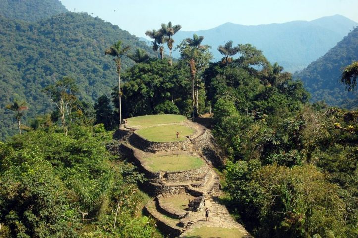
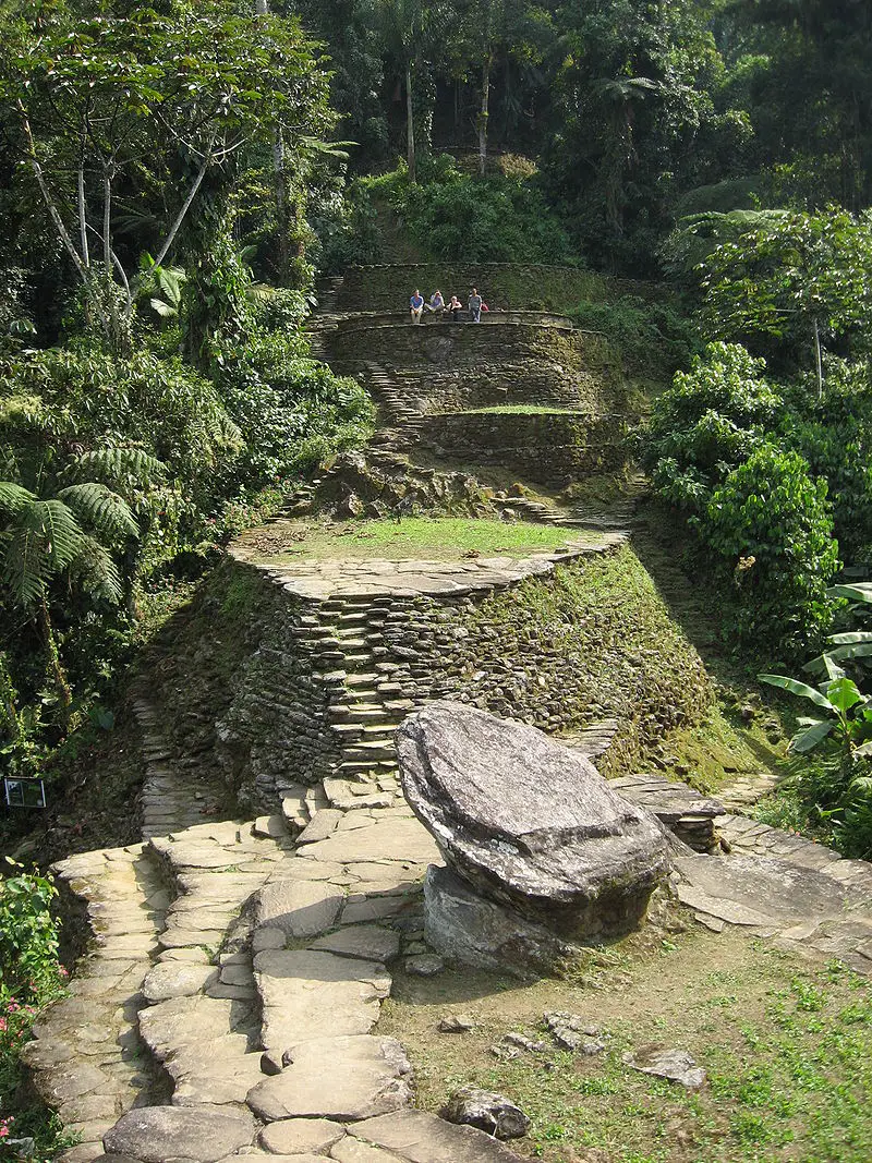
Lost City – Tayrona Park, Santa Marta
Beaches
In Tayrona, white sandy beaches with crystal waters surrounded by mangrove swamps and forests are the main attractions. The most visited ones are:
Cabo San Juan del Guia, which is beautiful and huge,
La Piscina (large shore and calm waves),
Arenilla (the small zone between Arrecife and La Piscina),
Cañaveral (where you find Ecohabs Tayrona, although you cannot swim in there),
La Piscinita(small zone next to Cañaveral apt for baths), and
Arrecifes (also not allowed to swimmers but with several campsites).
Hiking
There are 4 hiking trails that go from low to high difficulty and from 1 to 4 hours.
Kogui or Knowledge trail from Cañaveral to Arrecifes (low difficulty, one hour).
Arrecifes– Boca del Saco trail going through Arrecifes beach, the natural pool and Cabo San Juan del Guía (low difficulty, 2 hours).
The stone road to Pueblito from Cabo San Juan del Guía (high difficulty, 3 hours).
Calabazo – Pueblito – Cabo San Juan del Guía trail (highdifficulty, 4 hours).
Submarine fun
For those who are more adventurous, snorkeling and diving are available too. The areas for scuba diving are Isla Aguja and Granate, this activity is managed by the diving schools of the village of Taganga.
You can snorkel in Neguanje, in front of Playa del Muerto, or in the Tayrona natural pool. At Gayraca bay you can dive and snorkel.
Birdwatching
As mentioned above, birdwatching in Tayrona Park is one of the best activities since there is a huge diversity of avifauna.
Fauna and Flora observation
Other animals that can be observed here are the howler monkey, cotton-top tamarin, deer, ocelot, and the jaguar, reptiles such as the blue poison dart frog, iguanas, and the American crocodile. Playful dolphins cheer lucky tourists too. Local flora includes evergreen trees, moss, bromeliads,and orchids.
Pueblito
Other activities are observation of cultural and archaeological heritagein architecturally important areas. One of them is Pueblito, where you can find ruins of the Tayrona ancient indigenous civilization, after a hike that takes about 3 hours. Its stone structures such as terraces, paths, and stairs are well-conserved.
Where to stay in Tayrona Park
There are different types of accommodation in Tayrona Park for all tastes and budgets.
Lodges
Cañaveral sector: 14 ecohabs (eco-lodges), all for double accommodation, but 11 with an option for extra beds for up to 4 people in family accommodation. Designed like the traditional indigenous houses with views to the Cañaveral beach.
Los Naranjos:ecohabs in FincaBarvolento, 2 minutes from Los Naranjos beach. 8 cabins with a private bathroom and terrace. There is also a private house on this beach, 5 minutes from the main entrance of the park.
Arrecife: 2 independent cabins, each one for up to 5 hosts, in Arrecife beach.
Camping zones
Several beaches offer zones to set a tent or a hammock and spend the night under the starred sky. These are:
Cabo San Juan offers a public bathroom and a restaurant. A small station of the Colombian Civil Defense is located there.
Playa Brava: a remote beach, 4 or 5 hours walking from Zaino o Calabozo, with public bathrooms, cabins, and a small restaurant.
Arrecife: the best beach to camp, near the police and Civil Defense stations and with a great restaurant. The camping area doesn’t have views of the sea, though.
Cañaveral: area without views of the sea, near La Piscinita.
Castilletes: Finca with large camping zones, public bathrooms, and a restaurant. Bathing in this stretch of sea is not allowed. You can get there directly by car.
Bahia Concha: the camping zone is shaded by large trees and the sea is calm and crystalline. You can get there directly by car.
Tayrona Park 2020 Entrance fees
The entrance fee to Tayrona National Natural Park varies depending on the nationality and age of the visitors, as well as the season of the year. These are the entrance fees for 2020:
Peak Season
(15 June – 15 July, 15 December – 15 January, Holy Week and long weekends)
Colombians, resident foreigners, and tourists from Bolivia, Ecuador, and Peru (ages 5 to 25): COP 20,000
Colombians, resident foreigners, and tourists from Bolivia, Ecuador, and Peru (over 25 years old): COP 28,500
Non-resident foreigners (over 5 years old): COP 63,500
Low Season
Colombians, resident foreigners, and tourists from Bolivia, Ecuador, and Peru (ages 5 to 25): COP 18,000
Colombians, resident foreigners, and tourists from Bolivia, Ecuador, and Peru (over 25): COP 24,000
Non-resident foreigners (over 5 years old): COP 53,500
People born in Santa Marta (ages 5 to 25): COP 9,000
People born in Santa Marta (over 25 years old): COP 12,000
Children under 5 years old and Colombians over 65 years old have free entrance.
Additionally, depending on the vehicle you enter to the park in, you have a different fee:
Car: COP14,500
Van: COP37,000
Bus:COP 78,000
Motorcycle: COP10,000
What you should consider when you visit Tayrona Park
Entry hours are from 8:00 am to 5:00 pm.
The park has a daily capacity of 6,900 tourists, so make your reservations in advance.
Having yellow fever and tetanus vaccines is recommended.
Always carry your ID, it is required at the entrance.
The introductory talk about environmental education is mandatory.
The climate in the park and surrounding areas is tropical hot, with temperatures ranging from 27 to 35 °C (81 to 95 °F). Therefore, use light cotton clothes, preferably pants and long-sleeve shirts. Also, wear appropriate hiking shoes, water–resistant if possible.
Bring a cap, sunglasses, sunscreen, insect repellent, and a lantern.
Only swim in permitted areas. Bathing in the sea is allowed until 6 pm.
Access to the indigenous sacred places is forbidden
If you hire a guide, make sure they are certified and preferably local.
Don’t bring any plastic bags, alcoholic drinks, instruments, and pets to the park, these are not allowed. Also don’t leave garbage (even organics) anywhere.
#BreatheTayrona – During January/February, the Tayrona Park closes its doors for allowing the restoration of its ecosystems, by the request of the indigenous communities in the Sierra Nevada de Santa Marta. Check the status of the park before your trip.
Current content writer for Sula. Modern Languages professional with an emphasis on business translation. Interested in the cultural adaptation of written and audiovisual content. Passionate about knowing new cultures and languages, tourism, and sustainable living.
All travelers visiting Colombia should visit the Mavecure Hills, a marvel of the Colombian Amazon region that remains unknown for many people.
In this post, you will find all the information you need to know to visit the Mavecure Hills. A bit of its history, how to get there, where to stay, the best time to visit, and also what other attractions you can find along the Inírida river.
Discovering the Mavecure Hills
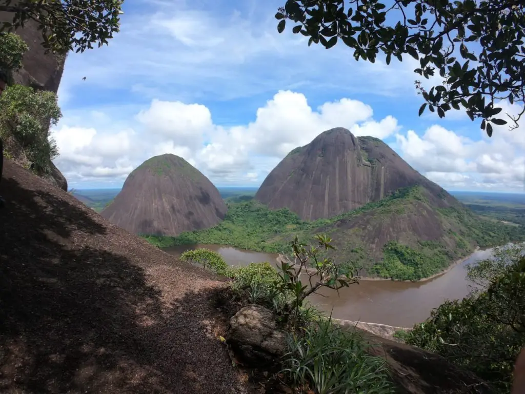
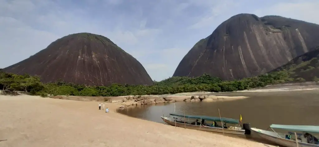
In southeastern Colombia, at some point in a river that looks like a large snake from above, three black, semi-rounded hills rise up as guardians of the pristine Amazon jungle that spans over the vast terrain. We’re talking about the Mavecure Hills -or Cerros de Mavecure– on the Inírida riverin the department of Guainía.
Pajarito, Mono, and Mavecure are part of the Guiana Shield, the oldest geological formations on earth, which are thought to be around 3,500 years old! The hills are made of volcanic rock –which gives them their dark color and reaches almost 800 meters. Specifically, Pajarito is 712 m (2,336 ft), Monois 480 m (1,570 ft), and Mavecure is170 m (560 ft).
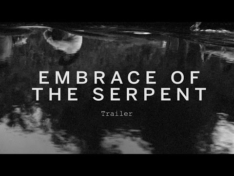
The region around the Mavecure Hills is inhabited by several indigenous tribes belonging to the Puinave ethnicity,which consider the monoliths a sacred site. Also, this Colombian remote travel destination became widely known thanks to the Oscar–nominated “Embrace of the Serpent”, a Colombian film that premiered in 2015 and directed by Ciro Guerra which displays a journey in the Colombian Amazonian jungle.
Legend has it that three orphan siblings lived on one side of the Inírida river. The oldest brother was passionate about birds, so he spent his days in Cerro Pajarito (Little bird).
The second brother loved primates, so he lived in Cerro Mono (Monkey). The youngest brother, however, did not have a connection with nature and used a blowgun to kill all that his brothers loved, without any regrets. Upset about the actions of the youngest, they decided to exile him to the other side of the river.
‘Mavi’ means cerbatana, a gun made of hemp that expulsed darts when blown, and ‘Cure’ refers to the poison used in the darts to kill the animals. This is the traditional story of the Mavecure Hills.
How to get to the Mavecure Hills
Mavecure Hills – Picture courtesy by Andrés Rodríguez
The Mavecure Hills are approximately 50 km (31 mi) south of Puerto Inírida city on the Inírida river, so they are only accessible by river. But first, here is how you can get to the city.
Satena Airline offers 5 weekly flights from Bogota to Puerto Inírida with a duration of 1 hour 45 minutes and flights 3 times a week from Villavicencio to Puerto Inírida. The Cesar Gaviria Trujillo airport is just 5 minutes from the city by car, you can take a taxi to take you downtown. The river is next to the city, so a short walk will take you to the port where you can get your boat ride to the hills. The sailing trip south lasts about 2 hours.
Where to stay at the Mavecure Hills
There are two options: staying in Inírida or staying next in the region of the hills.
Accommodation in Inírida
There are a few recommended hotels in Inírida, including Cabaña Guainiana Hotel, Toninas Hotel, Parature Hotel, Fuente del Guainía. Prices range from COP 80,000 to 20,000 per couple per night.
Accommodation in Mavecure Hills
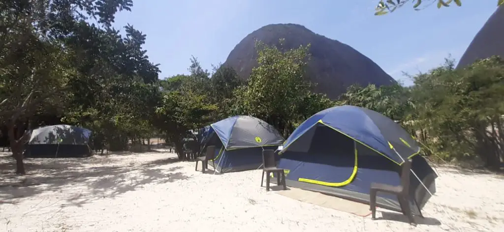
The immense Amazonian jungle surrounding Mavecure remains virgin and has no tourist infrastructure. Hopefully, it will stay this way. However, you can spend the night in a tent on the small beach in front of the three tepuis! This is free and allows you to enjoy an unrivalled landscape.
The alternative is to stay in one of the nearby indigenous communities -El Venado and El Remanso, which offer accommodation in hammocks or simple beds.
Mavecure Hills – Picture courtesy by Andrés Rodríguez, local indigenous guide.
Best time to travel to the Mavecure Hills
As Guainía and the Mavecure Hills are still undiscovered by most Colombians and foreign tourists, you can have a nearly private experience traveling there, but a general recommendation is to plan your Colombian trips avoiding the high seasons, which usually go from June to early August and from November to February.
What to do in Mavecure
Hiking
Once you get to the hills, you will want to climb to the top. This is only possible in Cerro Mavecure, the smallest of all. The hike is not that long -it takes about 50 minutes to reach the top, but since it is quite steep, the difficulty of the climb is medium to high.
On top of that, the weather in Guanía is hot and humid, with an average temperature of 28°C (82°F), which makes it a bit demanding. There are some wooden and metal stairs to help visitors climb easily, though.
The 360° view from Cerro Mavecure is worth all the effort! The majestic lush jungle divided by a meandering river of dark waters and all the life these places shelter is just breathtaking.
Know the Local Culture
Two indigenous communities that live near the Mavecure Hills, are El Venado and El Remanso. They are actually guardians of the hills and offer guiding services too. You can visit the settlements to spend the night or to start alternative trips through the jungle and nearby fishing lagoons. These are rustic places that have energy during some hours thanks to a power station.
La Ceiba is another community, located some kilometers north of Mavecure, where you can have two plans. The first one is ‘the honey route’, a tour where you learn the way that locals are developing a sustainable business out of beehives (beekeeping). The other plan is a river tour to sail next to the river dolphins, known astoninas, and watch the incredible sunset from a small beach.
River Trips
Now that you are in this part of Colombia, you should seize the opportunity to visit other wonderful attractions. By sailing north of Inírida, you will get to the Estrella Fluvial del Sur, the point where the Guaviare, the Atabapo, and the Inírida rivers converge to originate the great Orinoco River, one of the longest on the continent and the third–largest in the world. This happens at the border with Venezuela and the scene is amazing.
Shop souvenirs
The Coco Viejo community is the place to admire -and perhaps buy, their handicrafts. Locals make ceramics and different products such as baskets and bags woven in Chiquichiqui fiber. Also, there is where you find ancient petroglyphs (images carved on rocks) which are witnesses of the ancestral cultures.
Mavecure Hills – Picture courtesy by Andrés Rodríguez, local indigenous guide.
Know the Inirida Flower
Finally, another attraction in the region is the Inírida Flower Garden in the savannas, en route to CañoVitina. The Inírida Flower, the flagship flower of the region, has an exotic beauty that is worth a conservation project.
There are mainly two varieties: Flor de Verano (Schoenocephaliumteretifolium) and Flor de Invierno(Guacamayasuperba), which flower at different times of the year: December to March and June to October, respectively.
What you should consider for your travel to the Mavecure Hills
Although it is possible to travel to the Mavecure Hills independently, it is better to book with a local agency to avoid any hassles and feel safer with everything set.
At the port, look for boats with hoods as the sun is very intense for a 2-hour sailing trip.
Just in case it rains, pack a raincoat. It is also useful while you sail the river.
Bring enough water for you and your travel companions. Staying hydrated is key!
Consider the weather in the region to pack your clothes.
Support the local communities using their services and paying fair prices. With the income generated by tourism, they can have a better quality of life and keep working towards natural conservation.
Current content writer for Sula. Modern Languages professional with an emphasis on business translation. Interested in the cultural adaptation of written and audiovisual content. Passionate about knowing new cultures and languages, tourism, and sustainable living.
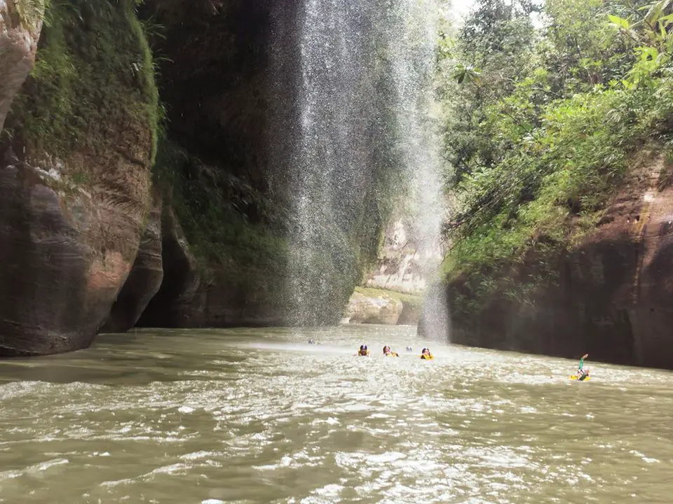
Many foreign travelers and even Colombians have no idea about the hidden treasure that the Canyon of the Guejar River is. Nestled in a remote zone of the Meta department, in the Colombian Llanos, the canyon formed by the Guejar river is just starting to be explored by adventurous travelers.
Some years ago, it was not possible to access the zone due to Guerrillas settlements, but now there is nothing to worry about, the place is safe and boasts incredible beauty. Turquoise waters that form natural slides, pools, waterfalls, and Jacuzzis, shaped by huge polished rock formations and surrounded by lush vegetation -these are the reasons to travel to theGuejar River in Colombia.
In this post, you will find all the information you need to know to travel to the Guejar River, such as what the charm of the Guejar River is, how to get there, the best time to visit, and what to do there.
Discovering the Guejar River
As already mentioned, the Guejar river is a natural treasure that remained hidden for many years until the 2010s. The view is stunning. A long river makes its way between big rock formationsthat easily beat the 20 meters high.
Some of these rocks are among the oldest on the planet, because they belong to the millenary Guiana Shield, which is born in Venezuela, crosses the La Macarena mountain range, and reaches Ecuador and Brazil.
The forest surrounding the stunning canyon is still pristine and undiscovered. The canyon is part of the special management area of La Macarena National Natural Park; hence it hosts amazing wildlife and flora. Birds and butterflies of all colors flying around you all the way. Sometimes, otters, sloths, and monkeys are spotted next to the river.
During the tour along the river, you will find refreshing natural pools, fun slides, waterfalls, and even Jacuzzis. If you like to watch wildlife in their habitat, go birdwatching, venture out into the wilderness to hike and explore rivers, mountains, forests, and plains so you have a deep connection with nature, the adventure activities, and interact with local cultures, the trip to the Guejar river is for you!
How to get to the Guejar River
There are two routes you can take to get to the Guejar river. Both pass by Villavicencio, the capital of Meta, but differ from the town you arrive in to stay the night and start your trip to the river.
Bogotá – Villavicencio
Depending on where you’re staying in Bogota, there are 2 highways you can take, both to the south of the city. From the southern city limits, there is 105 km (65 mi) until the city of Villavicencio, a trip of a bit more than 2 hours.
Route Villavicencio – San Juan de Arama
From Villavicencio, getting to San Juan de Aramameans traveling 120 km (75 mi) on a paved road, a trip that takes about 2.2 hours by car. You have to take the Ruta Turística del Ariari, which allows you to see the vast plains on both sides hosting different kinds of birds and even the Macarena mountain range.
There are 2 tolls on the road. You can stop by any establishment to taste the local delicacies. Once in San Juan de Arama, it just takes 15 minutes to get to the starting point of the rafting tour by the Guejar river canyon, which is within the village of Mesetas. Local guides take the visitors to the Limonar bridge in their 4×4.
Route Villavicencio – Lejanías
The route from Villavicencio to the village of Lejanías has a similar distance to the route to San Juan Arama, 126 km (78 mi) or 2.2 hours. A popular stop, 1.5 hours from the village, is Finca El Diamante, a small lodge where you can camp, stay the night in a cabin or just eat something before the adventure.
To get there you must pay a local to take you in a 4×4 or a motorcycle since the road is very bumpy. Once there, you have the advantage of only having to walk a few minutes through the forest to be facing the Guejar river.
Where to stay
San Juan de Arama
Hotel Palacio Real, you get a double room for COP 40,000–50,000with an air conditioner or fan.
Lejanías
Finca El Diamante in the “Maravillas del Guejar” viewpoint offers accommodation in cabins or camping. The price per person per night is COP 50,000 in a cabin and COP 7,000 in camping. Although the cabins can accommodate up to 6 people and the overall price is COP 100,000.
Cubarral
Hotel Casa Blanca Cubarral, you get a double room for COP 40,000–50,000with an air conditioner or fan.
Best time to travel to the Guejar River
There are no seasons in Colombia, at least the traditional 4 seasons that you have in North America or Europe. However, there is a rainy and dry season. During the rainy season, which goes from late March to November, you can see the CañoLajon waterfall in all its glory.
The access road, though, gets more complicated to travel along and, since the water flow rises, it is riskier to bathe or practice rafting in the river.
During the dry season, from December to March, you observe the color of the river get more vibrant, plus the cool water will be well appreciated because of the heat you’ll be standing.
To sum up, we consider that the best time to travel to the Guejar river is during the dry season.
What to do there
It is said that you can witness 5 marvels in the Guejar River, in no specific order:
Río Guejar Canyon experience courtesy Travesía Aventura.
Pozo Escondido is found by surprise on an ascending hike. It consists of natural pools of green waters that cannot be more refreshing.
CañoLajón waterfall is a wonderful sight, especially when the river flow is high you can enjoy a mightystream falling of rugged stones covered in moss. You can even stand behind the falls and freshen up with the mist.
Sliding down the slippery stone slabs is so much fun! You can find several natural slides that flow into turquoise pools.
At another point in the river, you can get a free massage in the natural Jacuzzis of the river, areas with a strong flow of water and small falls that offer pure relaxation. Water at this point is more crystalline and seems turquoise.
CañoJordán waterfall is also called ‘El vómito’ -the vomit, because of the shot that can be achieved from a precise angle in the viewpoint. This fall is a wonderful sight because of the intense green that frames it.
Rafting experience courtesy Travesía Aventura. Río Guejar Canyon.
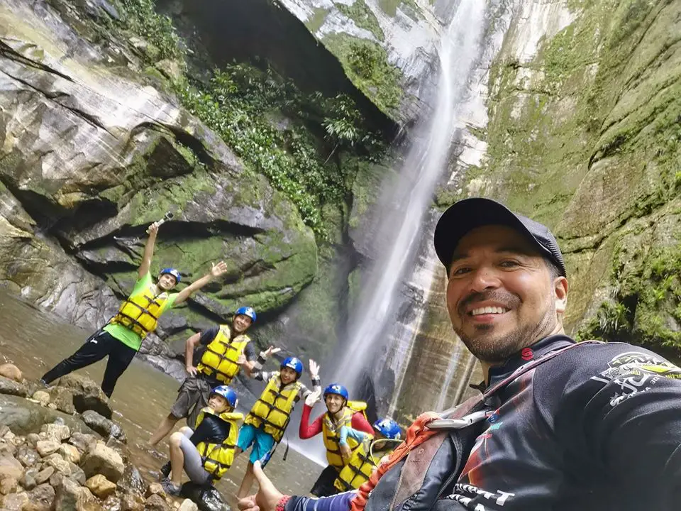
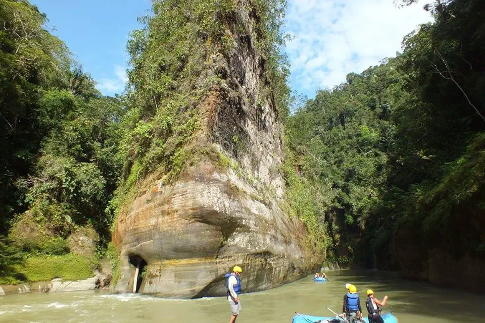
You can meet all these marvels on a hiking tour.However, rafting in the Guejar river canyon is the to-go option for the courageous travelers who want a rush of adrenaline in wild Colombia! A rafting tour takes about 5 hours, the distance to be covered is 17 km, 10.5 mi rowing with the hope of not falling off the boat.
The river is classified as level 3 out of 5 in difficulty.A big plus: midway through the journey, you find ‘the Titanic’, a sharp oval stone that seems like the front of a ship that has run aground in the middle of nature. This is the first stop, where there is time for having a snack, a talk, and a rest. Depending on the agency, the cost will be around 160,000 COP (40 USD) per person.
The Titanic – Rafting experience courtesy Travesía Aventura. Río Guejar Canyon.
What to consider for your travel to Guejar River?
For you to have an unforgettable experience in the Guejar river and no setbacks, consider the following aspects:
Wear light and comfortable clothes, long pants if you want to avoid mosquito bites and scratches. But shorts are fine.
Wear trekking shoes or shoes with grip soles that can get wet. Walking along the river is risky due to the slippery stones, so not wearing any shoes is not an option.
Wear a hat or cap, plus sunscreen. Also, bring insect repellent.
Don’t forget your swimsuit!
If you prefer, bring a towel and a change of clothes.
A GoPro is the most suitable equipment to record your experience, but if you bring any other device, make sure you have airtight plastic bags too.
Respect the environment, do not leave trash nor remove fauna or flora from their habitat.
Always book your tour with local guides and certified agencies to practice extreme sports.
This is all you need to know to travel to theGuejar River Canyon. If you are planning a trip to Colombia, we are happy to help you have an unforgettable nature experience! Contact us!
Current content writer for Sula. Modern Languages professional with an emphasis on business translation. Interested in the cultural adaptation of written and audiovisual content. Passionate about knowing new cultures and languages, tourism and sustainable living.
Trekking and mountaineering in Colombia are becoming more popular among all tourists, not only backpackers. This is because these activities provide a different experience that allows people to connect with nature while discovering incredible places. Both require a good physical condition though, so think of this when planning an expedition!
Colombia offers many trails for go trekking or mountaineering, from the world’s highest coastal mountain in the Caribbean coast to rock hills in the Amazon and some of the greatest snowy peaks in the imposing Andes mountain range that splits into 3 branches in Colombian ground.
If you are an adventurous traveler, you need to know the diverse trails for trekking and mountaineering in Colombia. Here they are!
Lost City, or Teyuna, is the greatest archaeological finding in Colombia. This ancient indigenous civilization was built in the Sierra Nevada de Santa Marta, along the Buritaca river, by the Tayrona culture.
Over 200 stone structures including interconnected roads, stairs, terraces, canals, and ceremonial buildings are the remnants of the city, which was forcibly abandoned during the Spanish colonization.
The round trip is 50 km long approximately and to enter, you must climb a 1,200 step stone stairway through the forest. This unique trek experience takes an average of 4 days but goes up to 6 depending on your physical level and stops done during the trip.
You will not only challenge your body but get to interact with Kogui local indigenous group and discover the immense biodiversity that inhabits this sanctuary. No need to say more, live the Lost City trek yourself!
The foothills of Sierra Nevada de Santa Marta merge into the intense blue-colored Caribbean sea, forming gorgeous white sanded beaches surrounded by mangroves and dense jungle with many endemic fauna and flora species. This is the breathtaking landscape you can appreciate in Tayrona.
To get to the camping zone from the entrance, you need to take a 2-hour hike and there are other trekking trails:
The Kogui trail or Knowledge route from Cañaveral to Arrecife lasts 1 hour and has a low difficulty level.
The Arrecifes – Boca del Saco trail, also moderate and 2-hour long, in which you can pass by Playa Arrecifes, La Piscina and Cabo de San Juan del Guia.
Another popular trek is Pueblito, something like the mini version of Lost City where Kogui families live.
Los Nevados National Natural Park is in the Central mountain range of the Andes and comprises the three coldest thermal floors.
This means that here you can get to know Andean forest, paramo, and glacier ecosystems. 38 nearby municipalities and crop fields are provided with water thanks to the rivers that descend from the paramos and glaciers in the park.
The snowy mountains that belong to this protected area are Ruiz, Tolima, Santa Isabel, and El Cisne, Quindio, and Santa Rosa paramillos, which form the greatest volcano complex in the country.
Many tourists visit this park to climb to the highest peaks of these mountains that go up to 5,300 meters above sea level!
Currently, Nevado del Ruiz presents volcanic activity so access is restricted. Here are the two snowy mountains within the park you can climb to.
4. Tolima and Santa Isabel Snow-capped Mountains
With its peak at 5,220 MASL, Nevado del Tolima is one of the two currently available options for mountaineering in Colombia.
The excursions take 4 days in total and usually start from Ibague or Salento. When you get to the summit, a view over Los Nevados Park and the Magdalena valley will take your breath away -on sunny days, of course.
This is one of themost demanding treks in Colombia because of its steep slopes and only experienced mountaineers should attempt to climb to the 2.8 km2 glacier.
Located between the snowy volcanoes of Tolima and Ruiz, Santa Isabel is the lowest snowy mountain in Colombia.
Unlike others, it does not have a conic structure with a crater but a set of domes created by lava outpouring that allows the glacier thermal floor to existing. Poleka Kasue, as the Quimbaya indigenous culture called it, has its highest peak on the central summit at 4,968 meters above sea level.
Unfortunately, it suffered deglaciation in recent years, passing from 1.9 km2 to 0.5 km2 in 10 years. In fact, IDEAMstudies have determined that it would take only a decade for this glacier to become extinct.
The trip to Santa Isabel’s summit starts from Pereira, Santa Rosa de Cabal, or Manizales and takes 1 or 2 days to the summit.
Among the attractions of the trek is the viewpoint of Laguna del Otún and Paramillo del Quindío, and the gorgeous paramo landscapes that boast a frailejones valley and endemic flora and fauna species.
Once again, it is recommended to have experience in mountaineering and take all the safety precautions.
5. Puracé National Natural Park
Another Andean volcanic zone, this time declared a UNESCO Biosphere Reserve, this is Puracé NNP.
The Coconucos volcanic range has 11 volcanoes, among which Puracé is the only active one. The Magdalena, Cauca, Patía, and Caquetá rivers (some of the main rivers in Colombia) originate in this mountain, along with around 30 crystalline lagoons and several sulfur springs for hot baths.
It is located in the Cauca department and its name means “fire mountain” in the Quechua language, spoken by the homonymous indigenous culture that protects the territory. Puracé is a privileged spot for those looking for the majestic Andean condor, which soars over the paramo ecosystem.
Departing early from Popayan, a road takes you to the park entrance, where you will find various trekking trails: one directly to the volcano and others with lower difficulty that pass by its beautiful water bodies and are 20 kmlong approximately. The landscape is stunning and the park is quite calm.
Sierra Nevada of Güicán, El Cocuy, and Chita is the largest glacier mass in Colombia: within two mountain ranges it has over 20 snow peaks from 4,800 to 5,330 meters above sea level, Ritacuba Blanco being the highest.
It is located in the departments of Arauca and Boyacá and is sacred territory for the Uwa indigenous community, because of this there are some restricted areas.
This trek is particularly stunning cause you can find waterfalls, lagoons, important rivers such as the Magdalena or the Orinoco, frailejones, Andean condors, spectacled bears, and white-tailed deer! An unbelievable view.
Mountain climbers of all levels visit the park to go trekking for 5 days usually, although now there are simpler trails for one-day hikes that start from El Cocuy municipality. However, it is better to be in good shape for any trekking trail, especially at such high altitudes.
Notice: Since February 10th, 2020, El Cocuy NNP closed temporarily due to public order issues. Check its status on the web page before your trip.
Chingaza páramo is a National Natural Park on the Eastern range of the Andes, between the departments of Cundinamarca and Meta.
Here you will face a cloudy environment hiding the blue sky, which reflects on the lakes surrounded by frailejones. Plus, it is possible to spot spectacled bears, deer, pumas, páramo tapirs, Andean condors, and Andean Cock-of-the-rock in the lower areas near Villavicencio.
Trekking trips start from Guasca or La Calera municipalities and depending on the starting point, you will get to different lagoons. These water bodies were sacred to the former inhabitants, Muisca indigenous communities.
Among the most famous ones are the Siecha Lagoons, three small glacial lakes with high biodiversity around them. The maximum height you can reach is 3,800 meters above sea level and the route to the lagoons can be done in 1 day. This is an excellent option for practicing trekking near Bogota.
In the Guainia department, part of the Colombian Amazon region, three majestic rock hills rise from a pristine jungle by the Inirida river.
El Mono, El Pajarito, and Mavecure belong to the millenary Guiana Shield and can be reached by boat on a 3-hour trip from Puerto Inírida, the capital. Out of the three majestic black rounded hills, you can only climb Mavecure, which is 170 meters high.
Although it is not a really demanding hike that takes about an hour, the experience of sailing the river for hours and exploring a remote natural territory makes it a whole adventure.
Take into account that this is a tropical zone and the weather here is hot, therefore you should be vaccinated against tetanus and yellow fever, also you should dress properly (long pants and rain boots) and keep with you a piece of basic safety equipment.
Just 30 minutes away from Bogota, this eco-parkcovered by cloud forest offers several hiking trails for all adventurers. Although the routes individually do not take much time, there are over 20 km (12.5 miles) of hiking trails that you can complete in over 1 day, if you stay there, whether in camping zones, the hostel, cabins, or treehouses.
After going into the forest, you can get to the Eagle’s peak, a viewpoint at 2,290 MASL from where you can see the Tequendama region and the snow-capped peaks of Los Nevados NNP on clear days.
Other trails are:
Roquedal,667-meter long trail of high difficulty;
Butterflies, 1.6 km trail that leads to the hostel;
Oak Forest, 2.5 km trail surrounded by 30-meter oak trees;
Waterfall, 3.5 km long trail of high difficulty with a 70-meter high gorge; and the
Colonial trail, 1.5 km long which was used by Muisca and Panche natives to connect the Bogota plateau with the Magdalena valley in the pre-Columbian era.
It is worth visiting Chicaque park on the outskirts of Colombia’s capital.
These were 10 destinations to go trekking and mountaineering in Colombia in different regions of the country: the Caribbean coast, the Andes mountain range in the central region, and the Amazon jungle to the south.
From tropical to cloud forests, moorlands, and glaciers, trekking in Colombia is always a new adventure!
If you want to know more about the most incredible natural destinations in Colombia, plan your trip with us!
Modern Languages professional with an emphasis on business translation. Interested in the cultural adaptation of written and audiovisual content. Passionate about knowing new cultures and languages, tourism, and sustainable living.
Ciudad Perdida, or Teyuna, is the greatest archaeological finding in Colombia. This ancient indigenous civilization was built in the Sierra Nevada de Santa Marta by the Tayrona peoples.
It is located on the northern face of the mountain, in the upper area of the Buritaca river basin at 900 – 1,200 meters above sea level. The site is reportedly 12,000 square meters, although only 3,000 m2 are open for tourists.
Over 200 stone structures including interconnected roads, stairs, terraces, canals, and ceremonial buildings are the remnants of the city, which was forcibly abandoned during the Spanish colonization.
What remained of the stone roads and buildings is now claimed as a sacred territory of the Kogui, Arhuaco, Wiwa, and Kankuamo indigenous communities and also is an archaeological park, part of the Sierra Nevada de Santa Marta National Natural Park.
Lost City – Tayrona Park, Santa Marta
A look into the past of Ciudad Perdida
The Lost City -English for Ciudad Perdida- received this name because it remained hidden in the forest until the 1970s, when the government realized its existence after rumors of hidden treasures in the Sierra spread out.
Colombia’s Ciudad Perdida has been compared to Machu Picchu, and it was actually built around 600 years before the world-famous Peruvian ruins. The Tayrona architecture highlighted the circle as the main infrastructural element.
The preference for the circulation around the villages also stands out and is reflected in the extensive network of roads, stairs and platforms that allow internal mobility in the settlement.
A Place of Archeological Richness
Out of the 26 archaeological sites found in the river basin, the Lost City was the largest and most important of all, since it was assumed to be the political and cultural center of all the nearby settlements.
Archaeologists say that in the 16th century, Teyuna may have had between 1,500 and 2,000 inhabitants belonging to different political units with a language, architectural and cultural unity – the Tayrona culture.
The Conquest Period
The 16th century, when the Spaniards arrived on the continent was quite intense and the civilization faced intermittent periods of conflict and peace when the indigenous and Spaniards held exchange relationships.
The latter was never able to dominate the Tayrona civilization nor settle in the Santa Marta range. However, several factors – such as conflicts and new diseases, progressively destabilized and decimated the population.
The Indigenous People of the Sierra Nevada de Santa Marta
Today, the Kogi, Arhuaco, Wiwa, and Kankuamo indigenous peoples, inhabitants of the Sierra Nevada de Santa Marta, claim their right to this territory as descendants of the populations that inhabited it in the past.
These communities have learned to share their sacred land since the Teyuna Archaeological Park opened in 1980, but they demand respect for their traditions and territory.
Biodiversity of the Lost City Trek
The Sierra Nevada de Santa Marta is an important biodiversity reservoir due to its location in the Caribbean region of Colombia and the changes in elevation, known as thermal floors.
In Colombian mountains, every 1,000-meter increase in altitude means an estimated 3.5°F temperature decrease. This means that the higher you go, the cooler it gets, and also the ecosystems change.
The Santa Marta range presents a variety of wildlife including 90 species of fish, 49 amphibians, 92 reptiles, 184 mammals, and 631 species of birds!
Birding at the Sierra Nevada de Santa Marta
This is a paradise for birders since 36% of the Colombian avifauna -and 7% of the world’s avifauna- is found here.
It has Important Areas for Bird Conservation (AICAS) in different zones of the park, where you can spot the Andean Condor, the Santa Marta Parakeet, and the Blue-billed Curassow.
The Lost City Trek
Local tour agencies offer treks of 4, 5, or 6 days to Ciudad Perdida. In Sula, we have a 4-day tour. The journey starts in Santa Marta, where Jeeps pick up tourists and take them to the starting point of the Lost City Trek, El Mamey, which is about 3 hours from the city.
You will Arrive on Foot
The only way to get toTeyuna is on foot, so consider your fitness level if you plan to embark on this journey. The trek is about 50 km, you have to ascend and descend 4 small mountains… twice.
The daily hikes are at least 4 hours but can go up to 5 or 6 hours. Some quite steep stretches leave you exhausted but there is always time to rest. If you are physically trained, it will be OK; as long as you tolerate humidity.
Sendero en la Ciudad Perdida. Photo: Baquianos, travel and Adventure
You will have to cross the Buritaca river many times, sometimes –when the water is high, with the help of a rope. At one point of the climb, there is also a type of improvised, hand-operated cable car that helps trekkers cross the river one by one.
When your guide warns you it is the last time you have to cross the river, it means that the Lost City is really close. What separates you from the ancient civilization? Only a quite steep 1,200 step stone stairway!
Throughout the whole climb, you enjoy breathtaking views over the Caribbean sea and the tropical forest with exotic wildlife. But getting to the Lost City is another level of excitement.
Accommodation
There are several stops during the trek where you are offered snacks and hydration. The camps where you spend the nights offer really basic accommodation in cabins with bunk beds or hammocks.
You can carry your own hammock with a mosquito net and hang it if you prefer. These campsites are managed by local farmers or indigenous, and they offer you fresh food as well.
The Experiences
After the challenging trek, you will feel rewarded with the landscape and the peaceful atmosphere. This is the point where your guide talks about how the Tayronas build their civilization and lived kind of isolated in the forest.
It is a fascinating story that encourages you to go explore the ruins and, of course, take tons of pictures as souvenirs. One good thing is that Ciudad Perdida is not a massive tourist destination, so you won’t have to deal with hundreds of people disturbing your calm or ruining your selfie.
After this accomplishment, it is time to return. Two days of hiking and crossing the river again await you and your group.
Lost City
Recommendations
Get yellow fever and tetanus vaccines at least 10 days before your trip to the Lost City.
You need to wear one good pair of hiking shoes with good traction and waterproof if possible.
The type of shoes you wear is crucial since the weather is warm and humid, and the rain is always a possibility.
Wear long pants and breathable long-sleeved shirts to protect yourself from mosquito bites -these abound, and sunburns.
Pack enough underwear and sets of clothes, since you will get wet, whether because of the sweat or a well-deserved dip in the river.
If you have trouble sleeping in strange beds and in packed rooms, consider carrying your own hammock.
Take into account that you have to carry your luggage, so don’t overpack.
Be careful when drinking water in the camps, there have been people poisoned because of the questionable quality of water up there in the mountain.
Respect nature and the privacy of the indigenous peoples and farmers of the region.
Don’t throw garbage away.
Don’t take picturesof the communities or their belongings without their permission.
Contact a local agency with knowledge of the region, the trip, and the requirements.
We, in Sula, are happy to help you organize your Lost City trek!
The trekking to Ciudad Perdida in Colombia is an unrivaled experience for your soul and body. No need to say more, live the Lost City trekyourself!
Modern Languages professional with an emphasis on business translation. Interested in the cultural adaptation of written and audiovisual content. Passionate about knowing new cultures and languages, tourism, and sustainable living.