


Top 11 Lakes of Colombia: From the Andes to the Amazon

The lakes of Colombia are not lakes proper. Due to its extension, the water deposits of the Andean mountains are only lagoons. The largest are: Lake Tota, located at 3,115 meters above sea level in Boyacá, and Lake La Cocha, at 2,660 meters above sea level in Nariño. In Cundinamarca there is the Lake Fúquene and others of great importance Like the Suesca and Guatavita lagoons.
But don’t get confused! In Spanish lago (lake) and laguna (lagoon) definitions are not the same as in English.
In Spanish, a lake refers to a body of water that has an entrance and an outlet of rainwater, groundwater, and/or rivers, for example, the Lake Michigan or the Lake Superior in the USA, or the Lake Tota in Colombia. A lagoon, on the other hand, is a body of standing water that has an inlet from rivers or streams, but no outlet, for example the Great Salt Lake in the USA, the Caspian Sea in Asia, the Lake Corangamite in Australia, the Laacher See in Germany, and Lake Titicaca in Bolivia.
Now, in English, the difference between a lake and a lagoon, as well as its definition, is quite different. Lagoon is defined as a type of saltwater lake that is formed by the waves of the ocean. Also, lagoon is close to the ocean, whereas lakes are far away from oceans. Lagoon is saltwater body, whereas lakes are mostly freshwater bodies. Lagoons are generally shallow compared to lakes. And so on…
For an equal understanding, this is what you may call an exorheic and an endorheic basins, i.e. open and closed lakes respectively. And, translating to Spanish, lakes are exorheic and lagoons are endorheic basins. If you arrived here because of a homework about lakes visit National Geographic Encyclopedia about lakes. So… what is this post about?


Ok. This post is about the lakes of Colombia you can visit for fun and enjoy nature. Lakes of Colombia are also known, and called, as “lagunas” (lagoons), but they are not like the lagoons you are used to know. So, don’t get confused, when you visit a “lagoon” in Colombia, it will be, for sure, very far from the coastal zone, and it will be a freshwater lagoon, as you may have already noticed. And it can be lake… or not… geez!
In parentheses you will find the real type of water body that each lake or lagoon belongs to, according to the definition in Spanish.
Laguna de Tota
(Lake Tota, exorheic)
Location

Characteristics
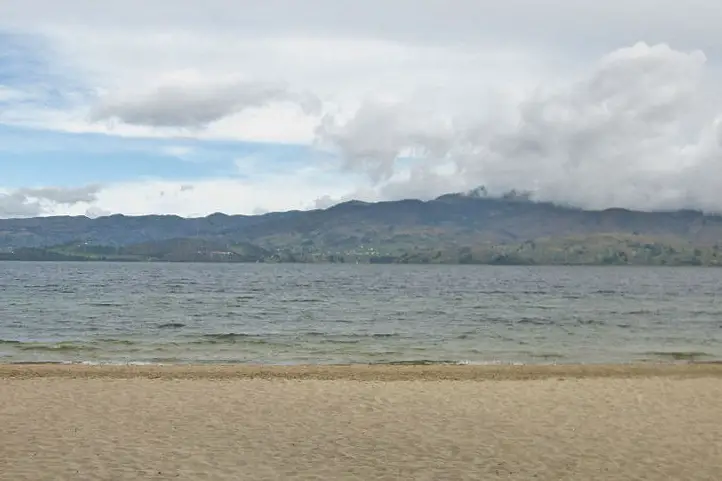
Exorheic Basin. With an area of nearly 55 km², it is the largest lake in Colombia and, after Titicaca, the second highest navigable lake in South America at 3,015 meters above sea level (9891.7 Ft.).
In the southwestern part of the lake, there is a natural bay called Bahía Blanca. It is frequented by bathers and water sports enthusiasts despite the low temperature that usually does not exceed 12 °C.
What to do
Despite the stories about the Tota Lagoon monster (Diabloballena), as terrifying as the Loch Ness monster (Nessie) in Scotland, today you can practice water sports, sportfishing, navigate the lake, walk through the forest, camp and enjoy Playa Blanca, the only cold-weather beach in Colombia.
When sailing you can visit the islands of the lagoon: El Sagrario de los Milagros, San Pedro, Cerro Chino, Santo Domingo, Isla del Amor and La Ballena.
Laguna de La Cocha
(La Cocha Lagoon, exorheic)

Location
Characteristics
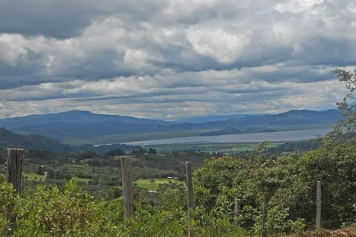
Lake La Cocha, also called Lake Guamués, is a natural lagoon of glacial origin, located in El Encano, a village in the municipality of Pasto, in the department of Nariño. With an area of nearly 40,5 km², it is the second largest natural body of water in Colombia, after the Laguna de Tota. It is located at 2680 meters above sea level (8792.6 ft.)
In 2000, Colombia registered the La Cocha lagoon, or Guamués lake, as a wetland of national and international importance within the Ramsar Convention, being the first with this qualification in the Colombian Andean region.
What to do
In this place it is possible to take boat trips, do sport fishing and bird watching.
Inside the lagoon there is the smallest flora sanctuary of Colombia, the Isla de la Corota Flora Sanctuary, with 15.2 hectares. It is located in the north of the Laguna de la Cocha. It is considered as a source of sacred energy for the indigenous and traditional doctors of the region. Likewise, it has a chapel that is an important pilgrimage site for Catholics, especially during the Virgen de Lourdes Festival. There you can walk trails designed to observe the forest.
Laguna de Guatavita
(Guatavita Lagoon, endorheic)

Location
Characteristics
This is the most famous sacred lake among our pre-Hispanic ancestors. The legend of El Dorado derives from it, a story that brought many people crazy about its relentless thirst for gold and wealth. The lake has suffered failed drainage attempts, made by these crazy treasure hunters.
It is located in the eastern mountain range of Colombia, at an altitude of 3,100 meters above sea level (10170.6 ft.) and has a temperature of 5 to 11℃. the lagoon has a maximum width of 0.7 km, a surface area of 19.8 hectares and an average depth of 125 m. It is supplied mainly by groundwater. It was formed in a perfectly circular mountain depression, surrounded by native forests. There are several hypotheses about its formation: by a meteorite, by a collapse caused by the dissolution of saline strata, or by glacial action and erosion. Today it has reached a stage of sedimentation.
What to do
Its environmental recovery has allowed that, after many years, activities can be carried out such as hiking, and landscaping.
Laguna de Fúquene
(Lake Fúquene, exorheic)
Location
Characteristics
With an area of 30 km² and located at an altitude of 2540 meters above sea level (8333.3 ft.), the Fúquene lake has numerous islands, one of which was a sanctuary for the Muiscas. According to the legend, hidden under the waters and ready to defend his domains in the valley of Ubaté and Chiquinquirá, remains Fu, a god-demon with the head and tail of a fox and human body. His name in Chibcha is decomposed from “Fu” which means fox, and “quene” which means bed, which would be translated as the bed of the fox.
The local community depends directly on the lagoon, since it is a source of water for domestic, agricultural and industrial activities. It is also the habitat of several migratory and endemic species.
What to do
Its environmental recovery has allowed that, after 40 years, nautical activities can be carried out with small boats such as sailboats, kayaks and rowing surf.
Laguna de Otún
(Lake Otún, exorheic)
Location
Characteristics
The Otún lagoon is one of the highlights of the Los Nevados National Natural Park. This lake measures about 1.5square kilometers and is located at 3,950 meters above sea level (12959.32 ft.) in páramo ecosystem, being perhaps one of the highest that you can visit. Formed by volcanic and glacial action, it is fed mainly by the snowmelt of the Nevado de Santa Isabel. It is one of the most beautiful ecological hiking destinations in Colombia. It is located in the department of Risaralda, Colombia. Its waters seep under caverns formed by volcanic flows and give rise, together with Laguna La Leona, to the Otún River, which is the source for the aqueduct of the city of Pereira.
What to do
This lake is a great tourist attraction in Risaralda for its great beauty and for trout fishing. The trout is a species introduced to the lake. In the lake you can see the Ruddy Duck (Oxyura jamaicensis), owls and hummingbirds, while the landscape is dominated by frailejones (Espeletia sp.) and typical páramo grasslands. Besides fishing, you can also camp there.
Laguna de Iguaque
(Iguaque Lagoon, endorheic)
Location
Characteristics
The Iguaque lagoon is located near the municipality of Villa de Leyva in the department of Boyacá, Colombia. It has an area of 6.75 km² and an average depth of 105 m. It is located at 3,800 meters above sea level (12467.19 ft.) in the páramo ecosystem, with a temperature from 4 to 12ºC on average.
According to the Muisca legend, the goddess Bachué came out of the lagoon with a child, giving rise to the entire human race. Bachue is the “Good Woman” mother goddess of the Muiscas.
What to do
Visiting this sacred lagoon is believed to cleanse the soul and purify the spirit. The lagoon is protected as part of the Iguaque Fauna and Flora Sanctuary. There you can go hiking, go on scientific and research tours, observe fauna and flora, observe the cultural heritage, and enjoy the landscape.
Laguna de Sonso
(Lake Sonso, exorheic)

Location
Characteristics
The Laguna de Sonso or del Chircal, was decreed as a Natural Reserve since 1978 and regulated for the use of land, water and airspace in 1979.
It is located on the right bank of the Cauca River, between the municipalities of Buga, Yotoco and Guacarí, in the department of Valle dal Cauca. It has an area of 2,045 hectares, (covering 14 square kilometers of these municipalities), of which 745 correspond to the lagoon zone and 1,300 to the buffer zone. It is located 936 meters above sea level, with an average temperature of 23ºC, and a relative humidity of 75%, being an attractive space for various species.
What to do
The Lake Sonso is part of the RAMSAR international agreement signed on February 2, 2017. It has a perfect combination of aquatic birds and dry forest. In addition, it is a refuge for migratory and endemic bird species, totaling more than 300 species. For this reason the main tourist activity in the Sonso lagoon is bird watching and bird photography.
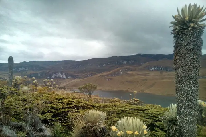
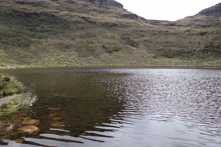
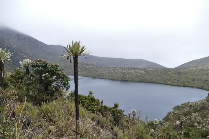
Lagoons at Natural National Park Chingaza
(Lakes of Chingaza, exorheic)
Location
Characteristics
The beautiful Chingaza National Natural Park is located in the eastern Andean mountain range of Colombia, between 3,050 and 3,950 meter above sea level (9858.924 – 12959.32 ft.). It has a great water richness constituted by the upper basin of several rivers, as well as by a lagoon system which has been declared a Ramsar site.
The Lacustrine system of Chingaza is formed by 20 lagoons and wetlands that supply water to the capital city, Bogotá. It is also of great importance for migratory birds.
Among all the lagoons, the largest is the Chingaza lagoon, with an area of 88 hectares, which contributes a high percentage to feeding the aqueduct that provides water to the city of Bogotá.
What to do
Four of the 6 trails enabled for ecotourism in the Chingaza park are to visit different lagoons:
- Lagunas de Buitrago Trail
- Laguna Seca Trail
- Plants of the Way – Laguna de Chingaza Trail
- Lagunas de Siecha Trail
You can do guided mountaineering in the modality of “hiking without camping” towards the lagoons. You can also contemplate the landscapes of lagoons, wetlands and streams, as well as observe the flora and fauna of the páramo.
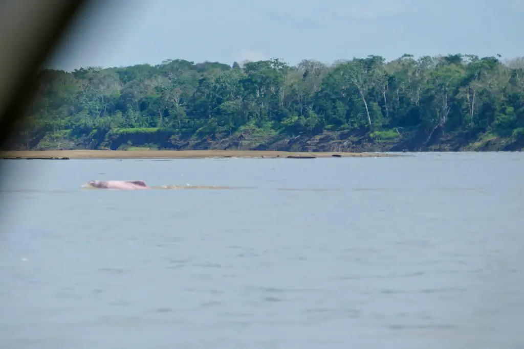
Lakes of Tarapoto
(Lakes of Tarapoto, exorheic)
Location
Characteristics
It is located in the municipalities of Puerto Nariño and Leticia, department of Amazonas. The lakes of Tarapoto are a strategic ecosystem made up of more than 30 interconnected lakes, which reach an approximate area of 11,424 m2 in periods of low water. According to Ramsar.org, this ecosystem:
“provides important functions such as flood and erosion control, waterways for transportation, recreation and tourism.”
Besides being one of the greatest ecotourism attractions in the region, this biome is the means of subsistence and food for 22 indigenous communities, Cocama, Ticuna and Yagua, which are part of the Ticoya reservation in the Amazon.
It has been declared a Ramsar area in 2018, thanks to the joint work between the inhabitants of Puerto Nariño, the indigenous people of the Ticoya reservation, the Omacha Foundation, the Colombian government, Corpoamazonía, the Sinchi Institute and the World Wide Fund for Nature (WWF).
What to do
There you can arrive by boat and wait in silence for the appearance of pink dolphins, while contemplating the majesty of the Amazon jungle.
Lagoons at Natural National Park Sumapaz
(Lakes of Sumapaz, exorheic)

Location
Characteristics
Bogotá has the largest and most beautiful páramo in the world, the Páramo of Sumapaz. This ancestral place was considered by the Muiscas as the habitat of the gods.
Here you can enjoy unique landscapes, unique animals and the particular vegetation of an ecosystem that is dedicated to safeguarding water: the páramo.
What to do
In the Sumapaz páramo you can visit the following lagoons:
Alar Pasquilla Lagoon
According to the District Tourism Institute of Bogotá, the Alar Pasquilla lagoon is one of the seven wonders of the city. This sanctuary full of frailejones, imposing cliffs and a 3,200-meter-high viewpoint is a unique plan.
Negra lagoon
This body of water has been the object of legends, which is why it can be considered the most mysterious lagoon in the páramo of Sumapaz. In pre-Columbian times, when the Zaque de Hunza (Tunja) and the Zipa de Bacatá (Bogotá) were at war, it was known as the Saguanmachica lagoon, because a zipa with that name was crowned there.
Los Colorados Lagoon
Also known as the enchanted lagoon, this paradise is a place that few know because of its difficult access.
Los Tunjos
They are the best known bodies of water in Sumapaz because it is easy to get to them. This area has a forbidden route, where you can see lagoons and cliffs as high as the Colpatria building.
Larga Lagoon
In this lagoon of the Sumapaz National Natural Park it is common to see fish, wild ducks and other types of birds. Access is very easy, because it is close to the Los Tunjos complex.
Laguna Cajitas lagoon
This body of water at 3,850 meters high is famous because the Black-chested Buzzard-eagel can be seen frequently. The best panoramic view of the lagoon is on Cerro La Carolina, a difficult place to access because you have to climb for about an hour.
Laguna de Cumbal
(Lake Cumbal, exorheic)

Location
Characteristics
The Cumbal lagoon, also called La Bolsa lagoon, is located at the foot of the Cumbal volcano, at 3440 meters above sea level (11286.09 ft), in the department of Nariño, south of Colombia.
This lagoon is characterized by the gray color of its waters, the very low temperature and the absence of waves. The Cumbal lagoon basin is small in size (9.8 km²) and is located in a very sensitive aquifer recharge zone.
It is a sacred place for the indigenous people of the region, who belong to the grasslands ethnic group, and according to them, humanity originated there. For this you infer this place is of feminine energy, and it recalls the uterus of a woman, that is why it is called the bag.
What to do
You will be able to enjoy a majestic landscape of mountains, valleys, nearby volcanoes and see the snow-capped mountains of the Republic of Ecuador.
You can also do sport fishing activities, since the rainbow trout abounds in its waters. You can also meet the indigenous inhabitants of the area, their culture, traditions and gastronomy.
Recommendations
To enjoy it to the fullest, we recommend you take comfortable, warm and waterproof clothing. You should also wear mountaineering boots that are waterproof. In some places you may be short of breath due to the altitude, in that case, breathe deeply and slowly, and walk at your own pace. There will always be people watching over you and taking care of you so that you get the best experience.
If you want to know more about Colombian nature tours, or want to visit any Lake of Colombia, follow us, write us comments, or just contact us.
References
- WorldAtlas Website: What Are The Differences Between A Lagoon And A Lake?
- Rutas de los Andes Blog https://rutasdelosandes.com/
- Wikipedia
- WikiAves de Colombia
- Colombia Travel
- Colparques Website
- National Natural Parks of Colombia Website
- Ramsar.org
- Semana Journal
About the author
Sara Colmenares
Current director of Sula. Doctor in Biological Sciences. Her main interests are to explore and understand the organism – environment interactions, taking advantage of emerging knowledge for the management and conservation of species and ecosystem services. She is currently working as a consultant in functional ecology, ecosystem services and conservation projects in Colombia related to ecotourism and birdwatching.