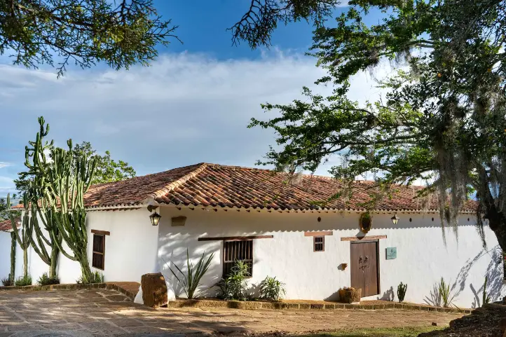
Guaduas, in Cundinamarca, is another heritage town of Colombia. According to historians, the Villa de Guaduas was founded on April 20, 1572 on the old Camino Real that led from Honda -one of the most important ports on the Magdalena River- to Santafé (today Bogotá).
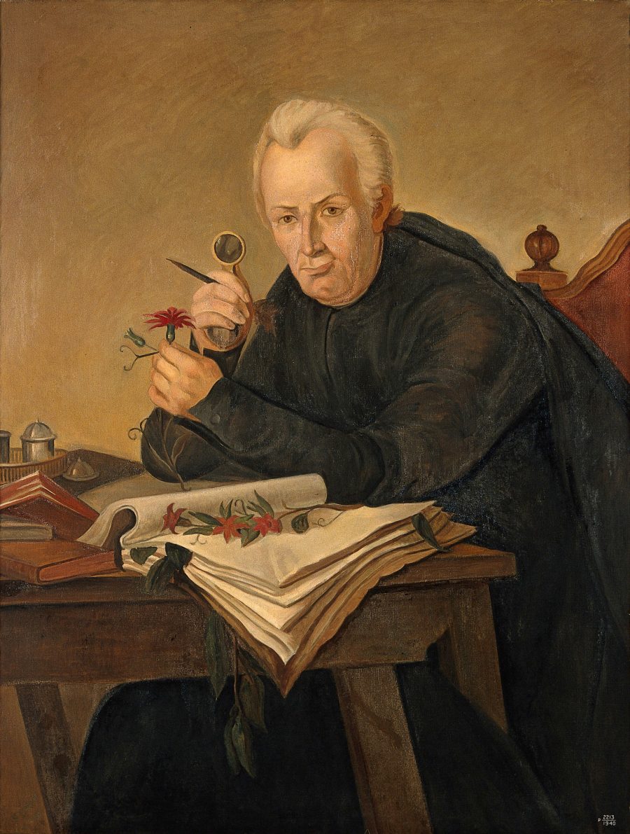
Along the Camino Real that crosses it, the old Guadueros saw the passage of viceroys and independence leaders – with Policarpa Salavarrieta and José Antonio Galán at the head – to the members of the Botanical Expedition who, led by José Celestino Mutis, had in Guaduas one of their main research centers.
In fact, one of the most remembered personalities of this town is the painter and botanist Javier Matiz, who masterfully captured images of the wide variety of the country’s flora on plates.
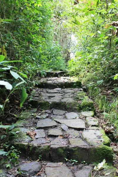
Its historic center, declared a national monument in 1959 (today an Asset of Cultural Interest), and its surroundings tell all this history through its monuments, mansions and vestiges, including a long cobblestone stretch of the Camino Real, which is still preserved.
Aware of the patrimonial value they have in their hands, and of its tourist potential, inhabitants, merchants and hoteliers have taken on the task of rehabilitating it little by little, and of projecting Guaduas as an ideal destination, in every sense of the word.
Discovering Guaduas
The town had 3 moments of foundation: the first foundation was in charge of Andrés Díaz Venero de Leiva, in 1572, and a second moment, given in December 1610, in charge of the Franciscans founded the convent of Nuestra Señora de Guaduas, located on the road to Honda. Finally in 1644, in the place called Villa de San Miguel de Guaduas.
Guaduas is located in the northwest of the department of Cundinamarca; the town has 2 areas that describe the geographical conditions that you will be able to enjoy; on the one hand the proximity to the Magdalena River and a flat, slightly undulating area of exuberant vegetation and warm climate. On the other hand, the area to the east comprises a mountainous system belonging to the Cordillera Oriental.
Guaduas is the birthplace of important figures of the country, among them Policarpa Salavarrieta, La Pola (Guaduas, 1797 – Bogotá, 1817), patriot heroine, apparently born in Guaduas. Also, Francisco Javier Matís (Guaduas, 1774 – Bogotá, 1851), painter and botanist of the Botanical Expedition, among other important figures.
Guaduas is considered as the little Colombia, thanks to the history and historical events that occurred there.
How to get to Guaduas
To get to Guaduas you must take a 3-hours road trip from the west of Bogotá city for 180 km, it is the same route you will take to Hinda, so you will be able to enjoy the different thermal floors and beautiful landscapes on your way.
Where to stay in Guaduas
In Guaduas you will find a great infrastructure, depending on your budget and personal tastes you can choose; our recommendations for you are: Camino a Santa Fé and Matisia Hotel Boutique.
Guaduas Attractions and Activities
La Pola’s House
You can find different articles that belonged to Policarpa aswell as to the members of her family. The house is humble and in keeping with the time, consisting of two rooms, a kitchen and patio. An ideal place to pay homage to such an important heroine.
Julia Castillo’s handicraft workshop
If you visit Guaduas you can not miss the opportunity to experience a unique clay handicrafts workshop, pieces of handmade collection, for the kitchen and home, the most curious thing about this workshop is that the base figure of the crafts is the figure of the hen kika.
Paragliding
You can spend a pleasant time for 30 or 45 minutes over the skies of the Magdalena River, you will have a beautiful panoramic view where you can not only appreciate the Magdalena, Guaduas and Honda.
Patio del Moro Museum of Arts and Traditions
During the tour in each of the rooms of this museum you can appreciate different pieces of collection of the colonial era such as clothing, beauty accessories and home accessories, being very typical for the inhabitants who once inhabited the town.
House of the Viceroys
It is considered a house of great importance in the town, since great celebrities lived there, among them Manuelita Saenz, who had a relationship with the liberator Simón Bolivar.
Piedra Capira Viewpoint
Is a beautiful viewpoint located 20 minutes from the center of Guaduas, where you will find a huge rock with a cross from where you will be able to appreciate a beautiful view of the Magdalena River, the snow-capped mountains of Ruiz, Santa Isabel and Tolima.
El Salto de Versalles Waterfall
The waterfall near the village no more than 40 meters high, here you can practice torrentismo and other ecotourism activities; is considered one of the most beautiful sector of Cundinamarca and an ideal place for photography lovers.
Santa Fe Royal Road
It is one of the most representative of the national routes that were made during the colonization period. It joins Bogota with the municipality of Honda, this road crosses the municipalities of Facatativá, Albán, Villeta and Guaduas.
During the tour you will be able to distinguish each of the marked stations: the Plaza de la Constitución as its center and longitudinally structured by the Camino Real, the Calle de la Pola and transversely by the Calle Real that links it with the Cemetery sector through the San Francisco Bridge.
Cathedral of San Miguel Arcángel
Its construction was initiated by the presbyter Justiniano Gutiérrez in 1809, from the design and the plans of Fray Domingo de Petrés. Its facade, of neoclassical style and impeccable white, has become one of the most recognizable images of Guaduas.
If you want to know more about Colombia, or wants to book your trip, please contact us.
References
Colombia Travel
Network of Colombian Heritage Villages
About the author
Luisa Martin
Engineer, world traveler, amateur photographer, traveling blogger, and foody.
Colombia has 5 deserts throughout its territory, which have very different characteristics due to their location. Besides, the deserts present in Colombia are arid and dry during most of the year, generating amazing landscapes, experiences that will leave you happy with your visit.
In this guide you will learn everything to enjoy exploring the deserts you can find in Colombia to the fullest.
La Guajira Desert
Located in the north of the country, in the department of Guajira. It is one of the most striking deserts thanks to the combination of the magical environment of the desert and the Caribbean Sea. The desert is divided into 3 sub-regions:
Alta Guajira: where its enormous dunes, cliffs, its enigmatic rock formations and its beaches of romantic and quiet atmosphere stand out; besides you can visit the Macuira National Natural Park.
Media Guajira: in this sub-region what stands out the most is the red sand that contrasts with the blue Caribbean sea. It is also very close to the Flamingo Flora and Fauna Sanctuary in the Boca de Camarones area and the Musichi Natural Reserve.
Baja Guajira: it is characterized for being the most humid area of the desert, located very close to the Sierra Nevada de Santa Marta. It is the birthplace of several sources of fresh water, such as the Ranchería River.
In your tour in this desert you will be able to know the wisdom of the Wayú, one of the most important indigenous communities in the country.
How to get to La Guajira Desert
Take a 1-hour flight from El Dorado International Airport (BOG) Bogotá to Almirante Padilla International Airport (RCH) at Riohacha city. Once at the airport, take an approximately 1,5- hours ride to Uribia. Once at Uribia you should take an extra 2-hours ride to Desierto de la Guajira.
Where to stay in La Guajira Desert
La Guajira desert does not currently offer accommodation for travelers. Therefore we recommend you to stay at Cabo de la Vela or at Riohacha:
La Candelaria Desert (between Raquira and Villa de Leyva towns)
It is located in the department of Boyacá, 7 km from the municipality of Ráquira and 32 km from the municipality of Villa de Leyva; also known under the name of “the desert of souls”, because it is away from all noise and offers an atmosphere of tranquility.
One of the most important characteristics is that its winds are very cold, since it is located in an area of moorland; however it has the geological conditions to be considered as a desert even has areas of fertile land where there is abundant vegetation making a wonderful contrast.
In this area of the department of Boyacá important archaeological findings have been made, so it is possible to find valuable cave paintings during your tour.
How to get to La Candelaria Desert
To get to the sanctuary you must take a 3.5 -hour road trip from the city of Bogotá to the town of Ráquira, total distance of 183 km.
When you are in Ráquira you must take a 10-minutes road trip of 7 km to Desierto de La Candelaria.
0 Where to stay in La Candelaria Desert
Due to the proximity of the desert to the town of Ráquira we recommend you to stay there:
This beautiful desert is located in the department of Huila near the municipality of Villa Vieja, being one of the most visited natural attractions in Colombia. It is also known as “The Valley of Sorrows” named this way thanks to the conquistador Gonzalo Jimenez de Quesada.
In addition the Tatacoa desert is a place of great importance for astronomy lovers because it has an ideal geographical location thanks to its low light pollution which facilitates the observation in detail of the stars and other phenomena of the universe such as meteor showers. Find out more about stargazing in our blog best places for stargazing in Colombia.
If you want to stay until night you can easily observe the stars and take beautiful pictures or if you want you can go to the astronomical observatory that the desert has.
By the way, the desert has 2 colors in different sectors; ocher in the Cuzco sector and gray in the Los Hoyos sector. When you are doing your tour in the Cuzco sector you will be able to reach an oasis in the middle of the desert where you will be able to take a refreshing bath.
How to get to La Tatacoa Desert
Take a 40-minutes flight from El Dorado (BOG) in Bogotá City to Benito Salas Airport (NVA) at Neiva city. Once at the airport, take an approximately 1-hour ride to Villa Vieja Town. At Villa Vieja take an extra 20- minutes boat ride to Desierto de la Tatacoa.
Where to stay in La Tatacoa Desert
Inside the desert there is a hotel where you can stay if you prefer instead of going to Villa Vieja: Bethel Bio Luxury Hotel.
La Tatacoita Desert in Nemocón.
Very close to the capital of the country, Bogota, is the Tatacoita desert, also known as “Checua”, which has a great geographic variety that you will discover when you get there.
The desert has gullies, sinkholes, estoraques and a canyon; in addition the colors that are presented in the strata mark the labyrinths present in the desert.
It is possible to make the tour of this desert in a couple of hours since its extension is small and reaches a maximum altitude of 2,000 meters above sea level. We recommend that you do the tour in the morning hours so you can see the change in color of the rocks when they come in contact with the sun’s rays.
How to get to La Tatacoita Desert
To get to the sanctuary you must take a 1 -hour road trip from the city of Bogotá to the town of Nemocón, total distance of 59 km.
When you are in Nemocón you must take a 35-minutes road trip of 11 km to Desierto de La Tatacoita.
Where to stay in La Tatacoita Desert
Due to the proximity of Bogotá to the town of Nemocón we recommend you to stay in Bogotá.
Occidente Desert, Santa Fe de Antioquia
Located in the department of Antioquia very close to the municipality of Santa Fe de Antioquia, being the most extensive arid area of the department.
It is possible that if you make the desert tour at midday you can experience temperatures above 35º C (95 ºF), also its heights are between 430 to 1300 meters above sea level.
How to get to Occidente Desert
Take a 1,5-hours flight from El Dorado (BOG) in Bogotá to José María Córdoba International Airport (MDE) at Rio Negro city.
Once at in Rio Negro you take an approximately 3,5-hours ride (56 Km) to Santa Fe de Antioquia. Antioquia. When you are in Santa Fe de Antioquia you must take a 10-minutes road trip of 11 km to Desierto de Occidente.
Where to stay in Occidente Desert
Due to the proximity of the desert to the municipality of Santa Fe de Antioquia we recommend you to stay there:
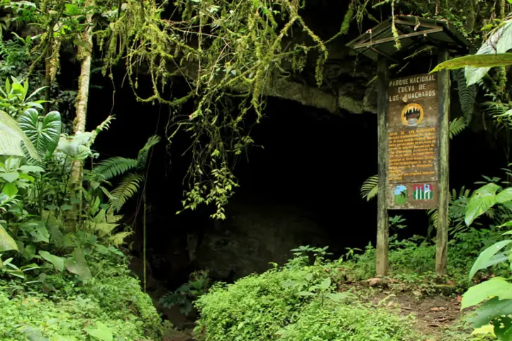
The Southern part of the department of Huila holds the oldest and one of the best-preserved protected areas in Colombia-. It is an amazing place where various endangered species are still preserved and protected, such as the Oilbird. We are talking about the Cueva de Los Guácharos National Park (Oilbirds Cave).
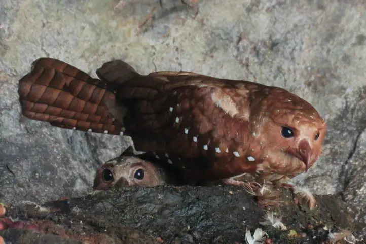
The Oilbirds, or Guácharos
For reference, Oilbirds (Steatornis caripensis) are birds that spend all day in the depths of the caves and go out at night to hunt food, usually insects, fruits, and aromatic plants.
Same as bats, Oilbirds also use a quite precise natural echo localization system. Hence, they make a series of short and squealing sounds that serve as waves that are used for their localization.
“it is named for the young birds, which are so fat that indigenous people and early settlers once collected and rendered them down to oil for lighting and cooking”.
It totals an area of 90 square kilometers and is located at the western flank of the Cordillera Oriental, between the departments of Huila and Caquetá. Also, the Cave of the Guácharos is very close to the Magdalena River.
Lastly, Cueva de Los Guácharos is considered part of “Andean Amazonian” transition ecosystems, having a great role as a water regulator, among other ecosystem services. Due to its unique characteristics, it is a nest and transitory refugee stop for a large number of migratory birds.
Weather
Cueva de Los Guácharos Park is between 1200 meters and 3800 meters above sea level and its temperatures vary between 19 °C and 26 °C, with very humid climatic characteristics.
How to get to the Cueva de Los Guácharos National Park
From Bogotá
Take a 1.5-hour flight from Bogotá to El Contador Airport (PTX) at Pitalito city. From Pitalito, take a 1-hour ride to Palestina, and an additional 1-hour car ride to La Mesura.
Once at Mesura, look for Cedar where the National Natural Parks access point to Cueva de Los Guácharos is located.
At this point, you can choose to take an 8.5 km hike (3.5 to 5 hours long) or take the transport service available to the accommodation area.
Bear in mind that Satena (Colombian national public airline) is the only one flying to Pitalito Saturdays and Mondays.
What to do in the Cueva de Los Guácharos National Park
Cueva de Los Guácharos National Natural Park has community-based ecotourism operators that provide lodging services in cabins and shared bathrooms for up to 50 people, a camping area for up to 24 people, restaurant service, horse rental, and guiding.
You must know that it is not possible to access or hanging around the park without the accompaniment of a local guide.
Hiking and Trekking
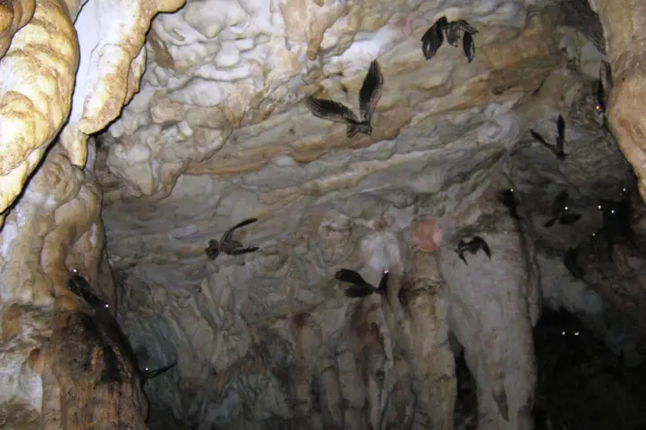
Within the area of the park, there are many canyons and labyrinths. The Cueva de Los Guácharos has caves formed by the chemical and mechanical action of the Sauza River and its tributaries.
Hiking is the most exciting activity in Cueva de Los Guácharos Park. You can hike only until the glacier edge along 4 trails:
Black Oak Trail with a 4-hour round trip (3.9 km) and high difficulty.
Giant’s Way Trail with a 2-hour round trip (2.7 km) and medium difficulty.
Rain of Crystals Trail with a 2-hour round trip (1.7 km) and medium difficulty
Waterfall of colors Trail with a 5-hour round trip (3.1 km) and high difficulty.
This activity allows you to admire the 2 caves of Oilbirds, the caves of calcareous formations, and the 2 natural bridges over the Rio Suaza. Also, the Cristales waterfalls, and the Lindosa waterfall.
Along the trails, you may spot the wonders of Cueva de Los Guácharos, among which stand out native species such as the Spectacled bear (Tremarctos ornatus), the Northern Pudu (Pudu mephistopheles), the cougar (Puma concolor), the long-tailed weasel (Mustela frenata), and the mountain tapir, also known as the Andean tapir or woolly tapir (Tapirus pinchaque).
Regarding flora, you will be able to appreciate almost extinct species in their natural state such as black oak (endemic), white oak, copper, black cedar, cumin, hayuelo pine, and the Colombian pine.
Birdwatching, and the Oilbirds Caves
Cueva de Los Guácharos is a permanent habitat for more than 300 species of birds including the Oilbird, the Andean cock-of-the-rock (Rupicola peruviana), and the Torrent Duck (Merganetta armata colombiana).
Do not forget that depending on the season different migratory birds that inhabit this territory may be observed.
Where to stay in the Cueva de Los Guácharos National park
The park has a Visitor Center called Andakí. The community-based ecotourism operator, Fundación Cerca Viva, provides lodging for 50 people in multiple accommodations (cabins), distributed in 5 bedrooms with bathrooms.
Additionally, the park also offers a VIP cabin with accommodation for 8 people and a private bathroom.
There is also a classroom for environmental education activities.
Best time to visit Cueva de Los Guácharos
The dry season (December to late February) is climate-wise the most preferable choice, however, it is also a peak season for national tourists so be prepared.
Worth noting is that usually between March and April Oilbirds’ offspring begin to hatch, which is considered a very attractive natural phenomenon.
Entrance fees
The entrance fee to Cueva de Los Guácharos varies depending on the nationality and age of the visitors. These are the entrance fees for 2021:
Colombians, foreigners holding a residence permit, and tourists from Bolivia, Ecuador, and Peru (ages 5 to 25): COP 15,000
Colombians, foreigners holding a residence permit, and tourists from Bolivia, Ecuador, and Peru (over 25 years old): COP 19,500
Non-resident foreigners (over 5 years old): COP 51,500
Children under 5 years old and Colombians over 65 years old have free entrance presenting their IDs.
What to consider when visiting the Cueva de Los Guácharos National Park
Book reservation in advance with an authorized ecotourism operator.
Wear suitable clothing for cold and humid weather.
Take reusable water bottles along.
Keep away from making any marks on trees, stones, or infrastructure available.
Noises or sounds that disturb the environment are not allowed.
Return ALL garbage and dispose of it at the waste disposal sites.
Admission of children under 5 years old, pregnant women, people with heart or respiratory conditions is not recommended.
Tours inside the park must be taken with registered and authorized guides.
Avoid taking night walks on the trails.
Some prohibitions
Feeding, bothering, or hunting animals, littering, pets, horses alcoholic drinks and drugs, making bonfires, throwing cigarette butts, burning garbage, felling, and capturing wildlife.
References
National Parks Website
Local guides
About the authors
Luisa Martin Engineer, world traveler, amateur photographer, traveling blogger, and foody.
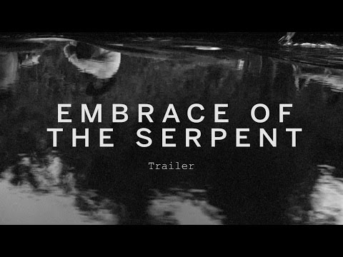
Two events have consolidated Guainía in the minds of travelers, the first, the signing of the peace agreement and the second, the launch of the Ciro Guerra’s film The Embrace of the Serpent (El Abrazo de la Serpiente), winner of multiple awards around the world.
Guainía
Guainía in the Yuri language means “Land of many waters”. Its capital is Inírida, and it is located in the east of the country. The temperature of the region oscillates between 25 and 30 degrees centigrade.
Most of its territory is made up of flat extensions, although there are some elevations, mainly the so-called tepuis, which are remnants of the Guiana shield, the oldest mountainous formation on the planet.
The most famous hills are the Mavecure, but there are others hills and mountains like the so-called Aracuari, Canapiari, Guasacavi, Mavicure, Pajarito, Rana, Salvaje, Sáquiras, Sardinas, and the mountains of Caranacoa and Naquén, with heights slightly above 500 meters above sea level.
In the past this was a region afflicted by armed conflict and violence, but this situation is now in the past and the community has found in tourism an opportunity for life.
Communication Routes and Transportation in Guainía
In the department of Guainía, the main communication route is the rivers, which are the road axes of access. Roads are scarce and only passable in the dry months.
It is also important the air transport. There are two airports located in Inírida and in the town of Barranco Minas.
Tourism in Guainía
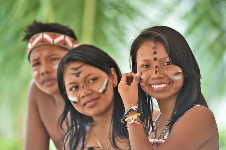
In Guainía one of the main attractions is its people, whose population is mostly composed of indigenous people (65%), who come from almost 30 different communities and belong to ethnic groups such as the puinave, curripaco, tukano, wanano, desano, piratapuyo, piapoco and yeral.
Guainía’s people
Other attractions are the Cerros de Mavecure, the Las Brujas lagoon, the Sapuara stream and the fluvial star. You can also find the Puinawai National Natural Reserve; the Pavón, Payara and Matevení Lakes, which together with the Inírida River, are destinations where you can practice water sports and sport fishing.
How to get to Guainía
You have to arrive by plane from Bogota to Puerto Inirida. The distance in straight line from Bogota is 720 Km, and it translates into 1 hour 10 min of flight.
It is recommended that you stay at least 4 days in the region to enjoy this majestic and sacred place.
In Inirida you can find several hotel offers, and all trips are made to and from the city by boat on the Inirida River and its tributary streams.
Below you will find the best destinations in Guainía.
Guainía Destinations
The Mavecure or Mavicure Hills
The Mavecure Hills are part of what we know today as deep Colombia. Embedded in the Amazon, they have become one of the most emblematic tourist destinations in Colombia.
In a study published about Ciro Guerra’s El Abrazo de la Serpiente, the Hills of Mavecure and surrounds are described as a landscape of enormousness, limitlessness, extraordinariness, and grandeur.
Mavecure Hills – Picture courtesy by Andrés Rodríguez, local indigenous guide.
The hills of Mavicure are three hours away from Puerto Inírida, the capital of Guainía. There are three tepuis called Mavicure, Mono and Pajarito that serve as an impressive viewpoint to the Guainía’s jungles.
From the top of the hills you can appreciate large extensions of jungle inhabited by indigenous communities such as the Puinaves and Curripacos.
According to Puinave Tomás Corda Medina, a native of the Barranco Tigre community, in an interview for a national newspaper:
“in the curripaco language, Mavecure comes from the words ‘mavi’, which is a palm used to make different utensils, and from ‘cure’, a poison that the ancestors took from a tree and put on the tips of their arrows for hunting with blowpipes.”
It is said that the hills were considered a magical space where humans could communicate with their gods.
The hills of Mavecure are 55 kilometers west of this city. To reach them you must take a speedboat that takes about 2 hours to travel the 55 kilometers through the Inírida River.
Climbing the Mavecure Hills
After arrival, you will have to spend the night in the El Remanso or in the El Venado indigenous communities placed at the foot of the hills.
You will need a guide to accompany you to the highest part of the hills, along the only trail suitable for walking and which does not require climbing equipment.
To reach the viewpoint, at 250 meters high, the only conditions are imposed by the weather and your physical condition. You must watch every step, and always go with a certified guide.
It is recommended to go up at a sunny moment. This is because, when it rains, the stone ground becomes slippery, and the slope makes the water run forming strong currents on the way down, which makes it very dangerous.
Once at the top you can see Pajarito and Mono; on their skirts you can see the dark green of a jungle that hides anteaters, water dogs, armadillos, limpets, chigüiros, tapirs, deer and tigers. In the distance, there are the caños that the river Inírida bathes, and other fluvial courses.
Mavecure Hills – Picture courtesy by Andrés Rodríguez, local indigenous guide.
The activities that you can do in the Mavicure Hills are bird watching, hiking, photography, and nocturnal fish watching on the banks of the Inírida River where you can see rays, guaracus, palometas, agujones and cuchas.
The Laguna de Brujas or Chalchuapa (in the language of the natives) is defined by the locals as an oasis of peace. It is a quiet place where you can escape to feel the sounds of birds and nature in all its splendor.
Situated 10 minutes by boat from Puerto Inírida, you will feel overwhelmed by the beauty of the surrounding forest. Laguna de las Brujas is announced as the preferred habitat of the pink dolphins.
A variety of stories are told among the natives, such as the legend of the “Pink Dolphin” which tells that spiritual leaders arrived there to talk to the pink dolphins about the future of the Amazon and its communities.
Others say that it was named after a legend about some witches who stole the water from another place known as “Hoyos de la caldera” (boiler holes), but during the trip they dropped the water in the air, forming the Brujas Lagoon.
The truth is that, regardless of their origins, tourists and locals can take tours through this splendid landscape in canoes, accompanied by an indigenous guide.
Caño Bocón
It is the paradise of fishing. Bocón is one of the main tributaries to the Inírida River. It is bordered by jungle.
This river is located in the territory of the Puinave ethnic community, thanks to which the river, and its lagoons, with its Peacock Bass and the large Payaras that live in it, are cared for and watched over.
Thanks to an agreement with the Puinave, fishing is allowed for a maximum group of 10 people, you will not see anyone else in fishing action during your week.
The fishing is fast and abundant: Peacocks, Payaras, Catfish, Palometas, Bocones, Morocotos, etc.
Viejita Lagoon
Another paradise for fishing in Colombia. Downstream from Puerto Inírida, where the river delivers its waters to the Guaviare.
After two hours of navigation towards the east, you can leave the river and walk around 15 minutes through the jungle until you reach the Viejita lagoon.
On a floating raft you go around the lagoon completely. From the raft you will witness epic sunsets and landscapes.
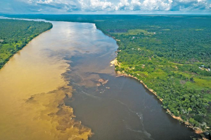
The Fluvial Star of Inírida (Estrella fluvial del Sur)
This is a must see in Colombia. This is a place where the rivers Guaviare, Atabapo and Inírida converge and swell the Orinoco River, one of the longest rivers in south American, and one of the top five largest rivers in the world.
Estrella fluvial del Sur, with its many rivers and lagoons, has been declared as a Ramsar Territory in 2014. This gave it recognition as a wetland of international importance, whose ecological and social value transcends the borders of a single country and benefits humanity.
The declaration of the Inírida River Star demand research efforts and substantial investments to safeguard the ecological integrity of the area. Ecotourism appears as a sustainable practice and activity compatible with the rational use promoted by the Ramsar Convention.
The River Star is home to 34% of Colombia’s wealth in freshwater fish species.
Colombia has the second largest number of freshwater fish species in the world.
The River Star is home to 70% of the known avifauna in Eastern Orinoco, 476 species of birds, two of which are exclusive to the place.
In the Inírida River Star there are 903 species of plants, 200 of mammals and 40 of amphibians.
The otter, the jaguar and the pink dolphin, present in the Fluvial Star, are in critical danger.
In the area there are two indigenous peoples, Puinave and Curripaco, five resguardos and 15 communities that inhabit them, who support and legitimize the decision of the declaration as a Ramsar territory.
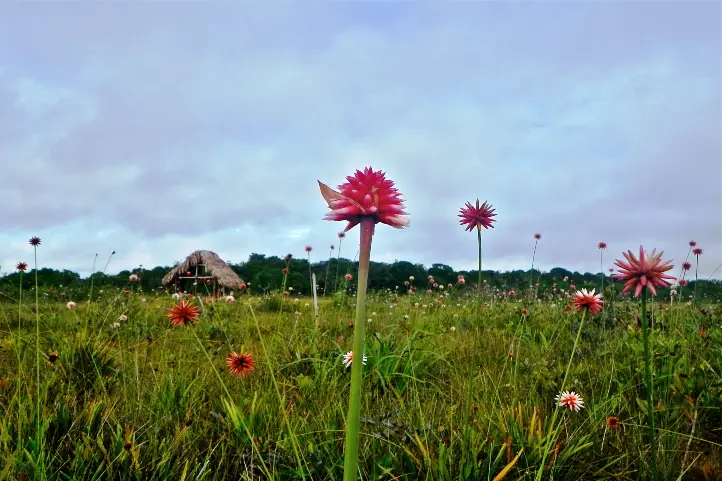
The Flower of the Inírida
It is an endemic plant of Guainía that grows in humid savannas and whose petals are red tips. Technically, the flower of the Inirida is two species of monocotyledonous herbs belonging to the family Rapateaceae. Both species are endemic to white-sanded savannas, with extremely poor, precarious soil conditions that are hostile to any plant.
Flowers of Inírida, winter Guacamaya superba, and summer Schoenocephalium teretifolium.
There are winter and summer ones and one is bigger than the other. The Winter Flower of Inírida (Guacamaya superba), the bigger one, blooms mainly during the rainy season in the region (June – October). On the other hand the Flower Summer of Inírida (Schoenocephalium teretifolium) blooms mainly during the season of drought (December – March).
Guainianos love and protect it and travelers admire it. It can be seen in all its magnificence in the savannahs on the way to Caño Bitina. During the flowering season, the savannah is dyed red because of the abundance of flowers.
Alto de Caño Mina
The Raudal Alto de Caño Mina, one of the tributaries of the Inírida River, is one of the most overwhelming in the Colombian Amazon.
This is one of the most emblematic destinations of this Secret Colombia. It has has a 15-meter waterfall of black, red and yellow waters. Its color is produced due to a great load of tannins it has.
It is necessary to go up the Inírida River for two days. Then you leave the Inírida River and enter through the Caño Mina.
Practice water ports such as skiing, diving and sport fishing.
Camping or hammock nights.
Hiking and trekking
Hiking through the forest to the indigenous community of Venado.
Recommendations
This is a trip to the jungle, so you have to be prepared for BASIC conditions of accommodation, food, transport etc. You will not find luxury things especially at night, because you will have to sleep in the community.
Additionally, take into account that the itinerary can vary according to the changes that the flights can have, the circumstances of the climate or unforeseen last minute.
Things you will need:
Wear comfortable, light-colored and lightweight clothing, hopefully waterproof.
Bring hats or caps for protection from the sun and wear a long-sleeved shirt.
Wear hiking shoes, preferably waterproof, and extra tennis shoes.
Photo or video camera to not lose any detail of these beautiful landscapes.
Abundant hydration for the walks, sunscreen and repellent.
A raincoat to cover yourself in case it rains.
Small backpack for the daily walks.
Flashlight.
Sleepwear. It is recommended to take a light sleeping, at night it can be cold.
Personal hygiene equipment in small quantities.
Tape, micropore and anti-irritation creams.
Camping equipment (tent, mattress) or hammock with ropes and tarp, depending on your preference for the first night.
Swimwear.
If you want to know more about the most incredible natural destinations in Colombia, plan your trip with us!
Current director of Sula. Doctor in Biological Sciences. Her main interests are to explore and understand the organism – environment interactions, taking advantage of emerging knowledge for the management and conservation of species and ecosystem services. She is currently working as a consultant in functional ecology, ecosystem services and conservation projects in Colombia related to ecotourism and birdwatching.
All travelers visiting Colombia should visit the Mavecure Hills, a marvel of the Colombian Amazon region that remains unknown for many people.
In this post, you will find all the information you need to know to visit the Mavecure Hills. A bit of its history, how to get there, where to stay, the best time to visit, and also what other attractions you can find along the Inírida river.
Discovering the Mavecure Hills
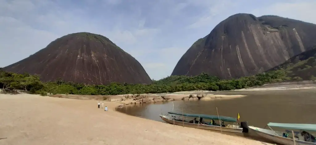
In southeastern Colombia, at some point in a river that looks like a large snake from above, three black, semi-rounded hills rise up as guardians of the pristine Amazon jungle that spans over the vast terrain. We’re talking about the Mavecure Hills -or Cerros de Mavecure– on the Inírida riverin the department of Guainía.
Pajarito, Mono, and Mavecure are part of the Guiana Shield, the oldest geological formations on earth, which are thought to be around 3,500 years old! The hills are made of volcanic rock –which gives them their dark color and reaches almost 800 meters. Specifically, Pajarito is 712 m (2,336 ft), Monois 480 m (1,570 ft), and Mavecure is170 m (560 ft).
The region around the Mavecure Hills is inhabited by several indigenous tribes belonging to the Puinave ethnicity,which consider the monoliths a sacred site. Also, this Colombian remote travel destination became widely known thanks to the Oscar–nominated “Embrace of the Serpent”, a Colombian film that premiered in 2015 and directed by Ciro Guerra which displays a journey in the Colombian Amazonian jungle.
Legend has it that three orphan siblings lived on one side of the Inírida river. The oldest brother was passionate about birds, so he spent his days in Cerro Pajarito (Little bird).
The second brother loved primates, so he lived in Cerro Mono (Monkey). The youngest brother, however, did not have a connection with nature and used a blowgun to kill all that his brothers loved, without any regrets. Upset about the actions of the youngest, they decided to exile him to the other side of the river.
‘Mavi’ means cerbatana, a gun made of hemp that expulsed darts when blown, and ‘Cure’ refers to the poison used in the darts to kill the animals. This is the traditional story of the Mavecure Hills.
How to get to the Mavecure Hills
Mavecure Hills – Picture courtesy by Andrés Rodríguez
The Mavecure Hills are approximately 50 km (31 mi) south of Puerto Inírida city on the Inírida river, so they are only accessible by river. But first, here is how you can get to the city.
Satena Airline offers 5 weekly flights from Bogota to Puerto Inírida with a duration of 1 hour 45 minutes and flights 3 times a week from Villavicencio to Puerto Inírida. The Cesar Gaviria Trujillo airport is just 5 minutes from the city by car, you can take a taxi to take you downtown. The river is next to the city, so a short walk will take you to the port where you can get your boat ride to the hills. The sailing trip south lasts about 2 hours.
Where to stay at the Mavecure Hills
There are two options: staying in Inírida or staying next in the region of the hills.
Accommodation in Inírida
There are a few recommended hotels in Inírida, including Cabaña Guainiana Hotel, Toninas Hotel, Parature Hotel, Fuente del Guainía. Prices range from COP 80,000 to 20,000 per couple per night.
Accommodation in Mavecure Hills
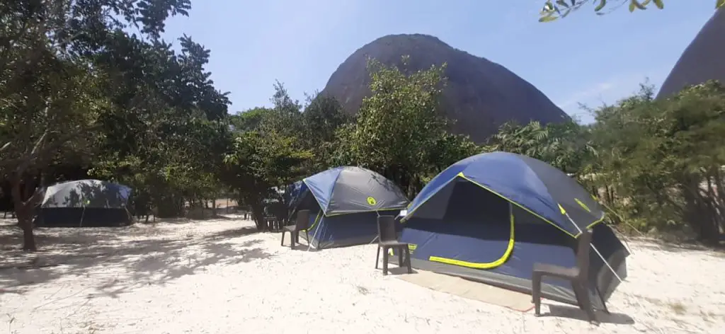
The immense Amazonian jungle surrounding Mavecure remains virgin and has no tourist infrastructure. Hopefully, it will stay this way. However, you can spend the night in a tent on the small beach in front of the three tepuis! This is free and allows you to enjoy an unrivalled landscape.
The alternative is to stay in one of the nearby indigenous communities -El Venado and El Remanso, which offer accommodation in hammocks or simple beds.
Mavecure Hills – Picture courtesy by Andrés Rodríguez, local indigenous guide.
Best time to travel to the Mavecure Hills
As Guainía and the Mavecure Hills are still undiscovered by most Colombians and foreign tourists, you can have a nearly private experience traveling there, but a general recommendation is to plan your Colombian trips avoiding the high seasons, which usually go from June to early August and from November to February.
What to do in Mavecure
Hiking
Once you get to the hills, you will want to climb to the top. This is only possible in Cerro Mavecure, the smallest of all. The hike is not that long -it takes about 50 minutes to reach the top, but since it is quite steep, the difficulty of the climb is medium to high.
On top of that, the weather in Guanía is hot and humid, with an average temperature of 28°C (82°F), which makes it a bit demanding. There are some wooden and metal stairs to help visitors climb easily, though.
The 360° view from Cerro Mavecure is worth all the effort! The majestic lush jungle divided by a meandering river of dark waters and all the life these places shelter is just breathtaking.
Know the Local Culture
Two indigenous communities that live near the Mavecure Hills, are El Venado and El Remanso. They are actually guardians of the hills and offer guiding services too. You can visit the settlements to spend the night or to start alternative trips through the jungle and nearby fishing lagoons. These are rustic places that have energy during some hours thanks to a power station.
La Ceiba is another community, located some kilometers north of Mavecure, where you can have two plans. The first one is ‘the honey route’, a tour where you learn the way that locals are developing a sustainable business out of beehives (beekeeping). The other plan is a river tour to sail next to the river dolphins, known astoninas, and watch the incredible sunset from a small beach.
River Trips
Now that you are in this part of Colombia, you should seize the opportunity to visit other wonderful attractions. By sailing north of Inírida, you will get to the Estrella Fluvial del Sur, the point where the Guaviare, the Atabapo, and the Inírida rivers converge to originate the great Orinoco River, one of the longest on the continent and the third–largest in the world. This happens at the border with Venezuela and the scene is amazing.
Shop souvenirs
The Coco Viejo community is the place to admire -and perhaps buy, their handicrafts. Locals make ceramics and different products such as baskets and bags woven in Chiquichiqui fiber. Also, there is where you find ancient petroglyphs (images carved on rocks) which are witnesses of the ancestral cultures.
Mavecure Hills – Picture courtesy by Andrés Rodríguez, local indigenous guide.
Know the Inirida Flower
Finally, another attraction in the region is the Inírida Flower Garden in the savannas, en route to CañoVitina. The Inírida Flower, the flagship flower of the region, has an exotic beauty that is worth a conservation project.
There are mainly two varieties: Flor de Verano (Schoenocephaliumteretifolium) and Flor de Invierno(Guacamayasuperba), which flower at different times of the year: December to March and June to October, respectively.
What you should consider for your travel to the Mavecure Hills
Although it is possible to travel to the Mavecure Hills independently, it is better to book with a local agency to avoid any hassles and feel safer with everything set.
At the port, look for boats with hoods as the sun is very intense for a 2-hour sailing trip.
Just in case it rains, pack a raincoat. It is also useful while you sail the river.
Bring enough water for you and your travel companions. Staying hydrated is key!
Consider the weather in the region to pack your clothes.
Support the local communities using their services and paying fair prices. With the income generated by tourism, they can have a better quality of life and keep working towards natural conservation.
Current content writer for Sula. Modern Languages professional with an emphasis on business translation. Interested in the cultural adaptation of written and audiovisual content. Passionate about knowing new cultures and languages, tourism, and sustainable living.
Being a megadiverse country and having a system of protected natural areas has allowed Colombia to start ranking as a worldwide ecotourism destination. In fact, regarding destinations for ecotourism, Colombia has it all!
Savannas, deserts, mountains, moorlands, snowy peaks, mangroves, rivers, two oceans, the Amazon… Every place you can think of is full of biodiversity and, fortunately, communities that work each day to preserve the natural wealth of the country.
What is Ecotourism?
To understand better what ecotourism is and what it’s not, you should know that it is a niche belonging to a larger market segment —nature tourism. Nature tourism comprises 3 niches, namely, ecotourism, adventure tourism, and rural tourism.
Ecotourismis the type of travel that involves natural areas, the participation of local communities and the promotion of environmental awareness.
It is beneficial for the conservation of the natural destination, the well-being of the community and the tourists themselves since they get a greater appreciation for nature and culture.
This is why the ecotourism sector is growing more and more around the world, especially in tropical countries like Colombia.
The niche of ecotourism, in turn,covers the following activities: bird watching, whale watching, observation of fauna and flora in general, and interpretive trails.
As a complementary product to ecotourism, interacting with local cultures during your trip —aka, cultural tourism, is totally recommended.
Best Ecotourism Destinations in Colombia
Now that you understand better what ecotourism is and what its activities are, here are the best destinations for doing ecotourism in Colombia, one for each specialized segment.
Birdwatching in Colombia
Birdwatching is the activity of observing, listening, photographing and identifying birds in their habitat. Some have birdwatching as a hobby, while others devote their lives to it.
Anyway, for amateurs and professional birders alike,birdwatching in Colombia feels like heaven. Over 1,900 bird species are found all around this country in really different environments, blended with native vegetation and exotic animals. This is why birding in Colombia is quite an experience.
La Guajira
There is an ideal destination for ecotourism —particularly for birdwatching, in the northernmost department of Colombia: La Guajira. La Guajira is also the northernmost tip of South America, being surrounded by the Caribbean sea.
Arid plains, dry forests and only 2 isolated mountains make up the overall landscape of this region, mostly inhabited by ethnic groups such as the Wayuu, Arhuaco, Koguis and Wiwa, Afro-Colombians and Arabs.
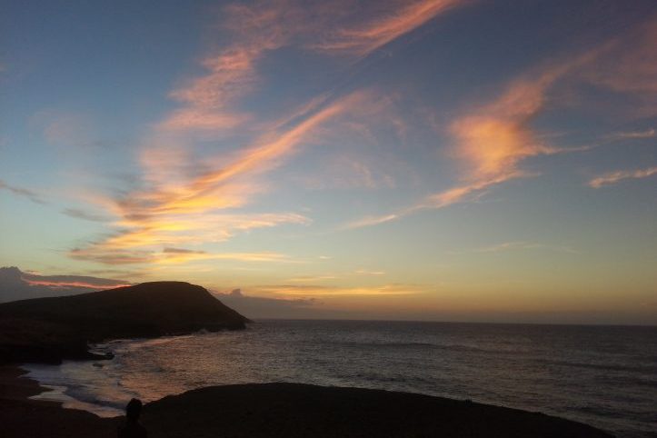
Sunset at Cabo de la Vela
The governmental abandonment in the region is evident in the lack of utilities, health care, and education, however, the population is leading sustainable initiatives to help conserve their natural and cultural heritage and bring livelihood to the communities.
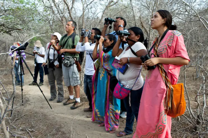
Avitourism is one of these initiatives that you can witness yourself. The dry forest of the La Guajira peninsula is a haven for around 500 bird species, 25 of which are near–endemic or restricted to such a dry ecosystem.
Picture from Audubon: “Wayuu indigenous students and teacher Alvaro Jaramillo are bird watching in La Guajira, Colombia this past June. The program teaches locals to become tour guides for travelers interested in spotting birds. Photo: Carlos Villalon”
There is a community organization, Birding Guajira, led by José Luis PuchainaEpiayu, a member of the Wayuu ethnicity and birdwatching guide specialized in La Guajira’s birds.
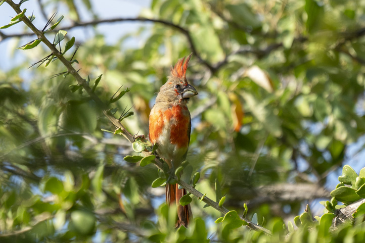
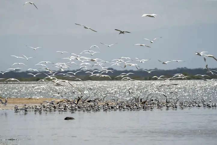
The Vermilion Cardinal (Cardinalis phoeniceus), the White-whiskered Tail and the Chestnut Piculet are the most representative birds you can find in the tropical dry forests. An aquatic tour through the NavíoQuebrado coastal lagoon will be your opportunity to observe the American Flamingos(Phoenicopterus ruber), along with other +150 migratory bird species.
Fauna and Flora Sanctuary Los Flamencos
But the experience is not over there. Full cultural immersion is also available to tourists. “Tardes de Ranchería” is the program that lets you know the Wayuu culture and share valuable timewith its members.
Talks about their myths, legends, and traditions are given. Also, you can taste typical Wayuu dishes, discover their crafts and witness their traditional dance —La Yonna. For this dance, they usually wear red or bright dresses in homage to the Vermilion Cardinal.
Finally, you have the chance to spend the night in achinchorro hammock, in a traditional ranchería.
Whale watching is an event that not everyone is privileged to witness. Fortunately for all the Colombia travelers, you can see whales on the Pacific coasts of Colombia! Visit our entry Whale watching in Colombia.
This is possible due to large groups of Humpback whales (Megaptera novaeangliae) migrating from Antarctica and Southern Chile during the winter to the warm waters of the northern Pacific Ocean to mate, give birth and raise its calves.
Chocó: Bahía Solano
Our whale watching tourin the Chocó town of Bahía Solano is a meaningful ecotourism experience, where you not only have fun sailing the Pacific Ocean to see the whales jumping out of the sea but you learn from a scientific perspective about these large mammals, the diversity of the region and also get to know the local culture.
Whether you enjoy taking pictures or videos of the whales greeting the tourists, or just saving the memory in your mind, you will have an unforgettable time.
Also, you can hear the whales’ songs through a speaker that reproduces the sounds recorded by a hydrophone. Fun fact: since these songs can last 10-20 minutes, they are thought to be the longest continuous vocalizations of any mammal!
Bahía Solano is an ecotourism destination par excellence. Its lush jungles next to the sea, its pristine beaches, its beautiful waterfalls, the wildlife it hosts, and the people that live there are a full package for nature travelers.
During our tour, we make a stop at the Mecana beach to have lunch at a local restaurant, take a dip in the river and tour the mangroves of the region while learning the importance of this ecosystem.
We work with local operators so that this activity represents the local communities an opportunity for development.
The interpretive trails are paths designed in natural reserves such as national or ecological parks “to enable visitors to understand more clearly the messages of history, the environment, or a nearly forgotten culture” (American Trails Organization).
This is a work achieved with local interpreters and support signs placed along the trails. Local interpreters have a deep knowledge of the history and biodiversity of the area since they’ve grown there and have been taught about the importance of preserving the natural heritage.
Chingaza National Natural Park
Chingaza National Natural Parkis one of the 23 protected areas in Colombia open for ecotourism. It is a paramo located on the eastern Andes, covering municipalities of Cundinamarca and Meta and accessible from Bogotá.
Lakes of Chingaza National Natural Park
A variety of fauna and flora thrives in the high Andean and sub-Andean forest and moorland ecosystems of the park. This is not the only reason to visit Chingaza, though.
The area is known to have been an indigenous territory, the land of the Muisca and Guayupe indigenous tribes. The stories of these ancient settlers remain alive and give meaning to the 6 hiking trails that currently exist:
Lagunas de Siecha trail;
Cuchillas de Siecha trail;
Lagunas de Buitrago trail;
Laguna Seca y Verde trail;
Suasie trail;
La Arboleda trail; and
Las Plantas del Camino trail.
The guided tours along these trails let tourists admire the stunning cloudy landscapes with crystalline lagoons and a bunch of Frailejones while learning about the ecosystem, its importance and the past inhabitants of the region that left a footprint.
Corpochingazais the community organization that offers guidance and environmental interpretation services in Chingaza.
Flora and Fauna Observation in Colombia
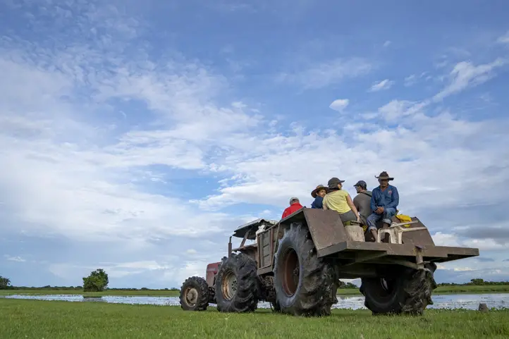
Casanare is one excellent ecotourism destinationfor flora and fauna observation in eastern Colombia. Casanare is one of the departments of Los Llanos, a region covering the Orinoco river basin and characterized by vast savannas inhabited by many wild animals, marshlands,llaneros (Colombian cowboys), joropo music and breathtaking sunsets.
Safari Llanero in Casanare
Here you can have the truly Safari Llanero experience, the adaptation of the African concept that seeks the observation and appreciation of the Neotropical fauna.
Traveling the wide plains of Casanare —whether in Jeeps, on horseback, on foot or even in light aircrafts –, lets you see capybaras, white-tailed deer, spectacled caimans, giant anteaters, giant otters, ducks, howler monkeys, owls, armadillos, red-footed tortoise, foxes, wild pigs, iguanas, and even anacondas, jaguars and cougars —if you are lucky.
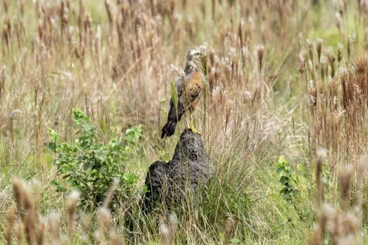
Safari in Casanare
Also birds such as the Orinoco goose, herons, the Double-striped Thick-knee, the Jabiru, owls, varieties of Ibis including the Scarlet Ibis, . As for the native flora, moriche palms (Mauritia flexuosa) stand out. There are several natural reserves in Los Llanos where you can live this adventure, uncover them here.
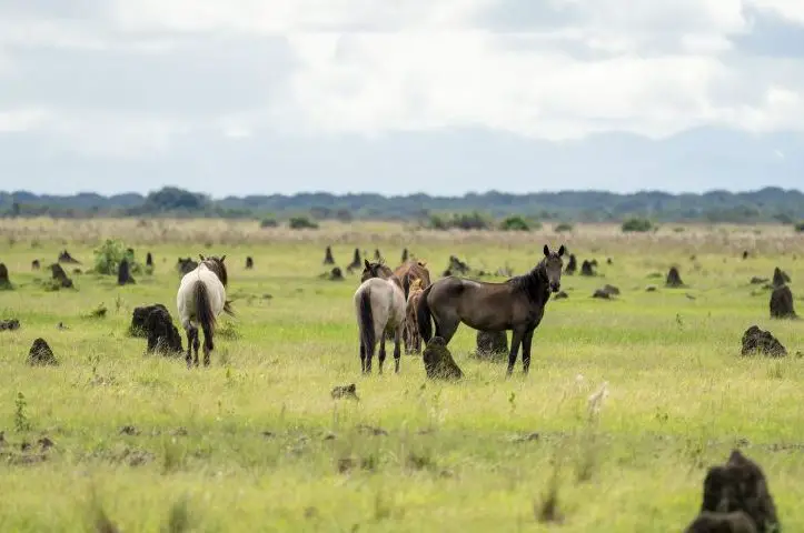
The Safari takes place in the early morning since the animals are more active then. Thanks to this, you have the afternoon free to immerse yourself in a Llanero experience.
You can participate in traditional horse rides through the rich savanna, observe the tradition of herding cattle for living and musical shows where locals sing folklore songs to the rhythm of guitars, harps and maracas about love, women, horses and the biodiverse Llanos. This is the perfect ending for an ecotourism trip.
Wild horses at Casanare
Hopefully this blog has cleared up your doubts about ecotourism, its products and some ecotourism destinations in Colombia. We are happy to help you plan your nature tripto Colombia.
References
Definition of Ecotourism by the The International Ecotourism Society (TIES)
Current content writer for Sula. Modern Languages professional with emphasis on business translation. Interested in cultural adaptation of written and audiovisual content. Passionate about knowing new cultures and languages, tourism and sustainable living.
Trekking and mountaineering in Colombia are becoming more popular among all tourists, not only backpackers. This is because these activities provide a different experience that allows people to connect with nature while discovering incredible places. Both require a good physical condition though, so think of this when planning an expedition!
Colombia offers many trails for go trekking or mountaineering, from the world’s highest coastal mountain in the Caribbean coast to rock hills in the Amazon and some of the greatest snowy peaks in the imposing Andes mountain range that splits into 3 branches in Colombian ground.
If you are an adventurous traveler, you need to know the diverse trails for trekking and mountaineering in Colombia. Here they are!
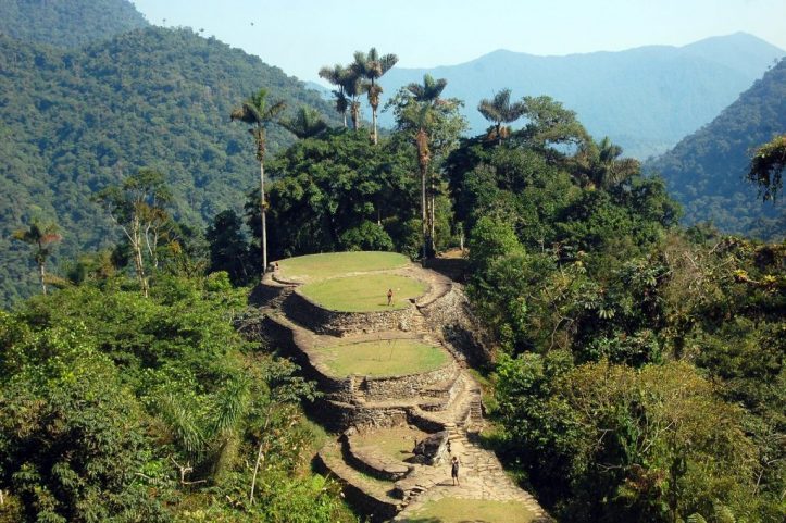
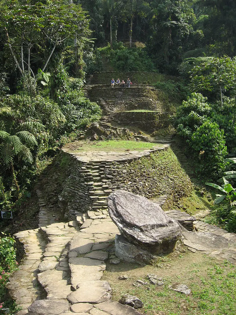
Lost City, or Teyuna, is the greatest archaeological finding in Colombia. This ancient indigenous civilization was built in the Sierra Nevada de Santa Marta, along the Buritaca river, by the Tayrona culture.
Over 200 stone structures including interconnected roads, stairs, terraces, canals, and ceremonial buildings are the remnants of the city, which was forcibly abandoned during the Spanish colonization.
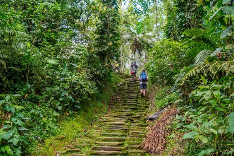
The round trip is 50 km long approximately and to enter, you must climb a 1,200 step stone stairway through the forest. This unique trek experience takes an average of 4 days but goes up to 6 depending on your physical level and stops done during the trip.
You will not only challenge your body but get to interact with Kogui local indigenous group and discover the immense biodiversity that inhabits this sanctuary. No need to say more, live the Lost City trek yourself!
The foothills of Sierra Nevada de Santa Marta merge into the intense blue-colored Caribbean sea, forming gorgeous white sanded beaches surrounded by mangroves and dense jungle with many endemic fauna and flora species. This is the breathtaking landscape you can appreciate in Tayrona.
To get to the camping zone from the entrance, you need to take a 2-hour hike and there are other trekking trails:
The Kogui trail or Knowledge route from Cañaveral to Arrecife lasts 1 hour and has a low difficulty level.
The Arrecifes – Boca del Saco trail, also moderate and 2-hour long, in which you can pass by Playa Arrecifes, La Piscina and Cabo de San Juan del Guia.
Another popular trek is Pueblito, something like the mini version of Lost City where Kogui families live.
Los Nevados National Natural Park is in the Central mountain range of the Andes and comprises the three coldest thermal floors.
This means that here you can get to know Andean forest, paramo, and glacier ecosystems. 38 nearby municipalities and crop fields are provided with water thanks to the rivers that descend from the paramos and glaciers in the park.
The snowy mountains that belong to this protected area are Ruiz, Tolima, Santa Isabel, and El Cisne, Quindio, and Santa Rosa paramillos, which form the greatest volcano complex in the country.
Many tourists visit this park to climb to the highest peaks of these mountains that go up to 5,300 meters above sea level!
Currently, Nevado del Ruiz presents volcanic activity so access is restricted. Here are the two snowy mountains within the park you can climb to.
4. Tolima and Santa Isabel Snow-capped Mountains
With its peak at 5,220 MASL, Nevado del Tolima is one of the two currently available options for mountaineering in Colombia.
The excursions take 4 days in total and usually start from Ibague or Salento. When you get to the summit, a view over Los Nevados Park and the Magdalena valley will take your breath away -on sunny days, of course.
This is one of themost demanding treks in Colombia because of its steep slopes and only experienced mountaineers should attempt to climb to the 2.8 km2 glacier.
Located between the snowy volcanoes of Tolima and Ruiz, Santa Isabel is the lowest snowy mountain in Colombia.
Unlike others, it does not have a conic structure with a crater but a set of domes created by lava outpouring that allows the glacier thermal floor to existing. Poleka Kasue, as the Quimbaya indigenous culture called it, has its highest peak on the central summit at 4,968 meters above sea level.
Unfortunately, it suffered deglaciation in recent years, passing from 1.9 km2 to 0.5 km2 in 10 years. In fact, IDEAMstudies have determined that it would take only a decade for this glacier to become extinct.
The trip to Santa Isabel’s summit starts from Pereira, Santa Rosa de Cabal, or Manizales and takes 1 or 2 days to the summit.
Among the attractions of the trek is the viewpoint of Laguna del Otún and Paramillo del Quindío, and the gorgeous paramo landscapes that boast a frailejones valley and endemic flora and fauna species.
Once again, it is recommended to have experience in mountaineering and take all the safety precautions.
5. Puracé National Natural Park
Another Andean volcanic zone, this time declared a UNESCO Biosphere Reserve, this is Puracé NNP.
The Coconucos volcanic range has 11 volcanoes, among which Puracé is the only active one. The Magdalena, Cauca, Patía, and Caquetá rivers (some of the main rivers in Colombia) originate in this mountain, along with around 30 crystalline lagoons and several sulfur springs for hot baths.
It is located in the Cauca department and its name means “fire mountain” in the Quechua language, spoken by the homonymous indigenous culture that protects the territory. Puracé is a privileged spot for those looking for the majestic Andean condor, which soars over the paramo ecosystem.
Departing early from Popayan, a road takes you to the park entrance, where you will find various trekking trails: one directly to the volcano and others with lower difficulty that pass by its beautiful water bodies and are 20 kmlong approximately. The landscape is stunning and the park is quite calm.
Sierra Nevada of Güicán, El Cocuy, and Chita is the largest glacier mass in Colombia: within two mountain ranges it has over 20 snow peaks from 4,800 to 5,330 meters above sea level, Ritacuba Blanco being the highest.
It is located in the departments of Arauca and Boyacá and is sacred territory for the Uwa indigenous community, because of this there are some restricted areas.
This trek is particularly stunning cause you can find waterfalls, lagoons, important rivers such as the Magdalena or the Orinoco, frailejones, Andean condors, spectacled bears, and white-tailed deer! An unbelievable view.
Mountain climbers of all levels visit the park to go trekking for 5 days usually, although now there are simpler trails for one-day hikes that start from El Cocuy municipality. However, it is better to be in good shape for any trekking trail, especially at such high altitudes.
Notice: Since February 10th, 2020, El Cocuy NNP closed temporarily due to public order issues. Check its status on the web page before your trip.
Chingaza páramo is a National Natural Park on the Eastern range of the Andes, between the departments of Cundinamarca and Meta.
Here you will face a cloudy environment hiding the blue sky, which reflects on the lakes surrounded by frailejones. Plus, it is possible to spot spectacled bears, deer, pumas, páramo tapirs, Andean condors, and Andean Cock-of-the-rock in the lower areas near Villavicencio.
Trekking trips start from Guasca or La Calera municipalities and depending on the starting point, you will get to different lagoons. These water bodies were sacred to the former inhabitants, Muisca indigenous communities.
Among the most famous ones are the Siecha Lagoons, three small glacial lakes with high biodiversity around them. The maximum height you can reach is 3,800 meters above sea level and the route to the lagoons can be done in 1 day. This is an excellent option for practicing trekking near Bogota.
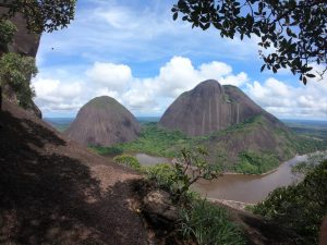
In the Guainia department, part of the Colombian Amazon region, three majestic rock hills rise from a pristine jungle by the Inirida river.
El Mono, El Pajarito, and Mavecure belong to the millenary Guiana Shield and can be reached by boat on a 3-hour trip from Puerto Inírida, the capital. Out of the three majestic black rounded hills, you can only climb Mavecure, which is 170 meters high.
Although it is not a really demanding hike that takes about an hour, the experience of sailing the river for hours and exploring a remote natural territory makes it a whole adventure.
Take into account that this is a tropical zone and the weather here is hot, therefore you should be vaccinated against tetanus and yellow fever, also you should dress properly (long pants and rain boots) and keep with you a piece of basic safety equipment.
Just 30 minutes away from Bogota, this eco-parkcovered by cloud forest offers several hiking trails for all adventurers. Although the routes individually do not take much time, there are over 20 km (12.5 miles) of hiking trails that you can complete in over 1 day, if you stay there, whether in camping zones, the hostel, cabins, or treehouses.
After going into the forest, you can get to the Eagle’s peak, a viewpoint at 2,290 MASL from where you can see the Tequendama region and the snow-capped peaks of Los Nevados NNP on clear days.
Other trails are:
Roquedal,667-meter long trail of high difficulty;
Butterflies, 1.6 km trail that leads to the hostel;
Oak Forest, 2.5 km trail surrounded by 30-meter oak trees;
Waterfall, 3.5 km long trail of high difficulty with a 70-meter high gorge; and the
Colonial trail, 1.5 km long which was used by Muisca and Panche natives to connect the Bogota plateau with the Magdalena valley in the pre-Columbian era.
It is worth visiting Chicaque park on the outskirts of Colombia’s capital.
These were 10 destinations to go trekking and mountaineering in Colombia in different regions of the country: the Caribbean coast, the Andes mountain range in the central region, and the Amazon jungle to the south.
From tropical to cloud forests, moorlands, and glaciers, trekking in Colombia is always a new adventure!
If you want to know more about the most incredible natural destinations in Colombia, plan your trip with us!
Modern Languages professional with an emphasis on business translation. Interested in the cultural adaptation of written and audiovisual content. Passionate about knowing new cultures and languages, tourism, and sustainable living.
Ciudad Perdida, or Teyuna, is the greatest archaeological finding in Colombia. This ancient indigenous civilization was built in the Sierra Nevada de Santa Marta by the Tayrona peoples.
It is located on the northern face of the mountain, in the upper area of the Buritaca river basin at 900 – 1,200 meters above sea level. The site is reportedly 12,000 square meters, although only 3,000 m2 are open for tourists.
Over 200 stone structures including interconnected roads, stairs, terraces, canals, and ceremonial buildings are the remnants of the city, which was forcibly abandoned during the Spanish colonization.
What remained of the stone roads and buildings is now claimed as a sacred territory of the Kogui, Arhuaco, Wiwa, and Kankuamo indigenous communities and also is an archaeological park, part of the Sierra Nevada de Santa Marta National Natural Park.
Lost City – Tayrona Park, Santa Marta
A look into the past of Ciudad Perdida
The Lost City -English for Ciudad Perdida- received this name because it remained hidden in the forest until the 1970s, when the government realized its existence after rumors of hidden treasures in the Sierra spread out.
Colombia’s Ciudad Perdida has been compared to Machu Picchu, and it was actually built around 600 years before the world-famous Peruvian ruins. The Tayrona architecture highlighted the circle as the main infrastructural element.
The preference for the circulation around the villages also stands out and is reflected in the extensive network of roads, stairs and platforms that allow internal mobility in the settlement.
A Place of Archeological Richness
Out of the 26 archaeological sites found in the river basin, the Lost City was the largest and most important of all, since it was assumed to be the political and cultural center of all the nearby settlements.
Archaeologists say that in the 16th century, Teyuna may have had between 1,500 and 2,000 inhabitants belonging to different political units with a language, architectural and cultural unity – the Tayrona culture.
The Conquest Period
The 16th century, when the Spaniards arrived on the continent was quite intense and the civilization faced intermittent periods of conflict and peace when the indigenous and Spaniards held exchange relationships.
The latter was never able to dominate the Tayrona civilization nor settle in the Santa Marta range. However, several factors – such as conflicts and new diseases, progressively destabilized and decimated the population.
The Indigenous People of the Sierra Nevada de Santa Marta
Today, the Kogi, Arhuaco, Wiwa, and Kankuamo indigenous peoples, inhabitants of the Sierra Nevada de Santa Marta, claim their right to this territory as descendants of the populations that inhabited it in the past.
These communities have learned to share their sacred land since the Teyuna Archaeological Park opened in 1980, but they demand respect for their traditions and territory.
Biodiversity of the Lost City Trek
The Sierra Nevada de Santa Marta is an important biodiversity reservoir due to its location in the Caribbean region of Colombia and the changes in elevation, known as thermal floors.
In Colombian mountains, every 1,000-meter increase in altitude means an estimated 3.5°F temperature decrease. This means that the higher you go, the cooler it gets, and also the ecosystems change.
The Santa Marta range presents a variety of wildlife including 90 species of fish, 49 amphibians, 92 reptiles, 184 mammals, and 631 species of birds!
Birding at the Sierra Nevada de Santa Marta
This is a paradise for birders since 36% of the Colombian avifauna -and 7% of the world’s avifauna- is found here.
It has Important Areas for Bird Conservation (AICAS) in different zones of the park, where you can spot the Andean Condor, the Santa Marta Parakeet, and the Blue-billed Curassow.
The Lost City Trek
Local tour agencies offer treks of 4, 5, or 6 days to Ciudad Perdida. In Sula, we have a 4-day tour. The journey starts in Santa Marta, where Jeeps pick up tourists and take them to the starting point of the Lost City Trek, El Mamey, which is about 3 hours from the city.
You will Arrive on Foot
The only way to get toTeyuna is on foot, so consider your fitness level if you plan to embark on this journey. The trek is about 50 km, you have to ascend and descend 4 small mountains… twice.
The daily hikes are at least 4 hours but can go up to 5 or 6 hours. Some quite steep stretches leave you exhausted but there is always time to rest. If you are physically trained, it will be OK; as long as you tolerate humidity.
Sendero en la Ciudad Perdida. Photo: Baquianos, travel and Adventure
You will have to cross the Buritaca river many times, sometimes –when the water is high, with the help of a rope. At one point of the climb, there is also a type of improvised, hand-operated cable car that helps trekkers cross the river one by one.
When your guide warns you it is the last time you have to cross the river, it means that the Lost City is really close. What separates you from the ancient civilization? Only a quite steep 1,200 step stone stairway!
Throughout the whole climb, you enjoy breathtaking views over the Caribbean sea and the tropical forest with exotic wildlife. But getting to the Lost City is another level of excitement.
Accommodation
There are several stops during the trek where you are offered snacks and hydration. The camps where you spend the nights offer really basic accommodation in cabins with bunk beds or hammocks.
You can carry your own hammock with a mosquito net and hang it if you prefer. These campsites are managed by local farmers or indigenous, and they offer you fresh food as well.
The Experiences
After the challenging trek, you will feel rewarded with the landscape and the peaceful atmosphere. This is the point where your guide talks about how the Tayronas build their civilization and lived kind of isolated in the forest.
It is a fascinating story that encourages you to go explore the ruins and, of course, take tons of pictures as souvenirs. One good thing is that Ciudad Perdida is not a massive tourist destination, so you won’t have to deal with hundreds of people disturbing your calm or ruining your selfie.
After this accomplishment, it is time to return. Two days of hiking and crossing the river again await you and your group.
Lost City
Recommendations
Get yellow fever and tetanus vaccines at least 10 days before your trip to the Lost City.
You need to wear one good pair of hiking shoes with good traction and waterproof if possible.
The type of shoes you wear is crucial since the weather is warm and humid, and the rain is always a possibility.
Wear long pants and breathable long-sleeved shirts to protect yourself from mosquito bites -these abound, and sunburns.
Pack enough underwear and sets of clothes, since you will get wet, whether because of the sweat or a well-deserved dip in the river.
If you have trouble sleeping in strange beds and in packed rooms, consider carrying your own hammock.
Take into account that you have to carry your luggage, so don’t overpack.
Be careful when drinking water in the camps, there have been people poisoned because of the questionable quality of water up there in the mountain.
Respect nature and the privacy of the indigenous peoples and farmers of the region.
Don’t throw garbage away.
Don’t take picturesof the communities or their belongings without their permission.
Contact a local agency with knowledge of the region, the trip, and the requirements.
We, in Sula, are happy to help you organize your Lost City trek!
The trekking to Ciudad Perdida in Colombia is an unrivaled experience for your soul and body. No need to say more, live the Lost City trekyourself!
Modern Languages professional with an emphasis on business translation. Interested in the cultural adaptation of written and audiovisual content. Passionate about knowing new cultures and languages, tourism, and sustainable living.
Historic roads are routes that have great historical importance. Nowadays they are becoming interesting destinations for trekking in Colombia.
They exist from the prehistoric era and the first ones were supposedly traced by animals and then adapted by humans. They were usually for trade and communication throughout big empires.
Famous Historic Roads
Some of the most representative and largest historic roads are the following:
Silk Road: trade routes that connected the East and West from the 2nd century BCE to the 18th century, specifically East, South and Southeast Asia with Persia, the Arabian Peninsula, East Africa and Southern Europe.
Amber Road: amber trade route from the coastal areas of the North Sean and the Baltic Sea to the Mediterranean Sea.
Royal Road: highway rebuilt by the Persian king Darius the Great in the 5th century BCE for facilitating rapid communication throughout the Persian Empire.
Post Track: causeway in the valley of the River Brue in the Somerset Levels, England that dates back to 3.838 BCE.
Red River Trails: network of ox cart routes between Canada and the US, from the 19th century.
Inca road system: the most extensive and advanced transportation system in pre-Columbian South America. It was about 39,900 kilometers (24,800 mi) long and the most famous section is the Inca trail to Machu Picchu.
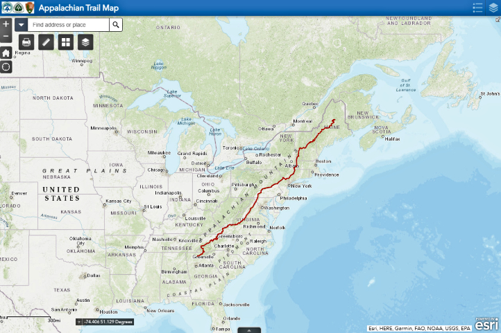
Nowadays, some historic roads have been the target of preservation efforts and, thus, adapted to tourism. One of the best examples is the Appalachian Trail.
Proposed in 1921 and built in the following years, this trekking trail is 3,500 km (2,200 mi) long and goes from north to south in the Eastern United States.
Thousands of hikers attempt to travel the whole trail, but only 1/4 achieve it and are called ‘thru-hikers’.
The Appalachian Trail boasts a natural and cultural heritage, and for this reason, the Appalachian Trail Conservancy was created, to ensure this unique place is well-managed and preserved.
In 1991, an International Appalachian Trail was created, which continues northeast from the US state of Maine to Canada and then, sections in Greenland, Europe and Morocco were founded.
Royal Roads in Colombia
Historic roadswere essential in the formation process of Colombia, since they allowed not only product exchange but culture and knowledge exchanges. In this way, the former isolated villages were becoming a network, a community, that offered tons of new opportunities.
Geography and population distribution throughout the country set a huge barrier for communication between the different settlements, so the ancient trails traced by native cultures have an incalculable value until today.
Although the first routes were opened by indigenous communities amid dense forests and steep mountains for religious and cultural reasons, the Spanish conquerors were the ones who forced the integration of national territory.
Most urban centers were established far from the coasts as the largest indigenous groups lived in inland areas. Coastal towns had easier communication with Europe than with the capital and other inland territories, so the need for a transportation axis across the country was evident.
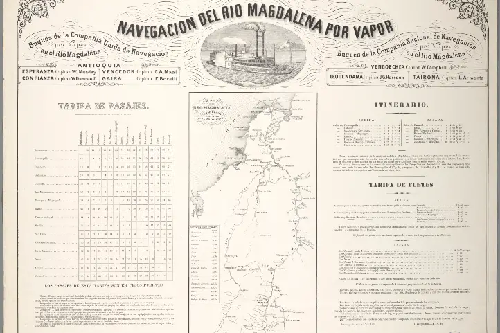
The Magdalena riverwas the axis to which several of the main hinterland roads converged, the royal roads.
Since the Spanish settlers sought to open new routes that helped the subjugation of the indigenous and the territorial integration, subsidies and benefits were offered to those who succeeded in opening crucial roads.
Later, from 1880 to 1930 the royal roads had their boom and transported volume of cargo and were traversed by travelers and mules as never before.
Since 1930, the bridle paths that allowed the inter-communication in Colombia experienced a crisis due to the introduction of wheel-friendly roads.
Royal Roads as Destinations for Trekking in Colombia
Nearly 80 years later, in 2008, Colombia’s Ministry of Culture launched the first project of cultural tourism in the country, which was about redesigning and reopening 3 routes of Royal Roads and was called ‘Recovery of Colombia’s Royal Roads‘.
The program aimed to analyze several variables of existing royal roads to determine its viability as cultural tourist attractions. The first royal road to be studied was the one located between Guaduas and Honda, which is 33 km long.
What motivated to undertake this project was the belief that “we must know, cherish and recover the Royal Roads, because they are essential parts of our memory and guiding threads to the future”, according to the then Ministry of Culture representative.
Now, these are the Colombian royal roads that are currently open for tourism. Check out some of our tours here!
Lengerke’s Royal Road
Some of the most beautiful colonial villages in Santander are connected by bridle paths built in the 19th century.
Geo von Lengerke, a German engineer, was the mastermind of these multiple roads that served to explore new territories and boost regional trade to and from the Caribbean coast along the Magdalena river.
Although the roads were planned by a foreigner, the construction was in charge of local labor. These represent a great architectural landmark, taking into account the complex topography of this region in northeastern Colombia. However, it has to be mentioned that the Guanes and Yariguies indigenous communities would have traced and traveled the roads before.
It is estimated that there are 800 to 1,300 km of roads with different conservation status, roads that demand a good physical condition since the trek is of intermediate to high difficulty.
The roads that helped the local economy thrive over 150 years ago, today keep their function, but in the tourism sector: they are favorite attractions among tourists visiting Santander.
One of the reasons is the big role that nature plays in beautifying the trek that passes by some of the best preserved villages of the region.
Itinerary of the trip along Lengerke’s roads
Barichara
The Lengerke’s royal roads are full of amazing viewpoints and a background that helps tourists connect with Colombia’s history and development, while enjoying nature. This is the itinerary of the trip along Lengerke’s roads:
First Stop. The journey starts in Mesa de los Santos, a warm municipality that offers extreme sports facilities and a renowned organic coffee.
Second Stop. Jordan is the next stop, reached after descending by the breathtaking scenery of the Chicamocha Canyon, which takes about 3 hours. Jordan connected the southern municipalities with Bucaramanga, Santander’s capital, so it was of high importance. There it is safe to camp and rest before continuing toBarichara.
Third Stop. The colonial village of Barichara was declared a World Heritage Site in 1978, since it keeps its classic infrastructure of narrow streets, white walls and yellow ground, which gives its inhabitants the nickname of ‘patiamarillos’ or the yellow-legged. Barichara has various cultural attractions you can visit during your stop.
Fourth Stop. The journey goes on to Guane, a small village that was the most important chiefdom for Guane indigenous community during the pre-Columbian era. Its church, Santa Lucía, is a National Monument.
Five Stop. The last leg of the trip is from Guane to Zapatoca, the town where Lengerke lived his last years. There is a great ecotourism offer in this place, including vineyards, the Nitro’s cave, La Lajita waterfall and the Azul and Ahogado wells.
Honda – Santa Fe Royal Road
This is the most representative historic road of those built during the colonial era. Starting from Honda, a commercial port by the Magdalena river, and passing by the villages of Mariquita, Villa de Guaduas, Chinauta, Villeta and Facatativa, it ended Bogota (formerly called Santa Fe de Bogota).
In colonial times, the Magdalena river was navigable up to Honda. The Spaniards made the town a starting point to travel to the center of Colombia.
The royal road, built by slave labor in the 16th century, was very rustic, considering the difficult terrain: it went up and down, went along mountains, valleys, rivers, small villages and unexplored land.
Despite that, everyone who wanted to get to Bogota, had to go through this route, the main communication path in the kingdom of Nueva Granada.
It was about 112 km long and most of it was between mountains, the rest was located in the Bogota savanna. Travelers completed the route in 6 days or less in the summer; however, during the winter, they could take twice.
José Celestino Mutis
The ‘Mutis Route’
The first route for cultural tourism was created to celebrate the 200th anniversary of the death of Jose Celestino Mutis. It is called ‘Mutis Route‘ and includes the most important towns where this wise botanist passed by during his famous ‘Botanical expedition‘, i.e the ones that formed the Honda royal road.
Its goal is the appropriation and recovery of the artistic, cultural and historical wealth of the villages, while generating income for the improvement of their life quality.
It has nearly 300 km from Bogota to Ibague and its paths can take between 2 and 7 days of traveling.
Itinerary of the trip along the Mutis Route
Some of the villages that are privileged to have a section of the royal road are focusing on its preservation and offer guided tours down the road.
Mariquita
In Tolima, this town was a key transit point in the royal road, that witnessed not only valuable goods but news about new scientific discoveries and ideas.
It was the headquarters of the Royal Botanical Expedition from 1783 to 1791, when it moved to Bogota.
Honda
It is in northern Tolima and became the main connection of the hinterlands with Cartagena and, from there, with Spain.
During the 18th century, its royal road had its boom, which lasted until the 20th century. Today, Honda is one of the Heritage towns of Colombia, thanks to its historical legacy.
Guaduas
This town is known to be the home town of Policarpa Salavarrieta, the heroine of Colombia’s independence, but before that, it was a key place in the route between Honda and Santa Fe de Bogota.
From the Capira Stone viewpoint, you can see the stunning Magdalena river valley and a section of the ancient Royal Road that leads to the capital of the country.
A civil society organization, along with young students, is in charge of maintaining the path for visitors to enjoy the travel along it.
La Mesa
Camino Real – Mutis Route, Tena, Cundinamarca,
La Mesa is a municipality in Cundinamarca situated on a plateau at 1,200 MASL and also played an important role in the road system of the hinterlands, serving as a mountain port.
It was a node of a network of several roads that came from nearby regions such as the Bogota savanna, the Magdalena valley and Tequendama.
Some of these stone paths have been preserved to this day, for example, the royal road to San Javier or ‘Camino del Resbalón’. Although short, this road is a fantastic work that is only disrupted by some paved crossroads.
Modern Languages professional with emphasis on business translation. Interested in cultural adaptation of written and audiovisual content. Passionate about knowing new cultures and languages, tourism and sustainable living.