When and Where to Go to See Humpback Whales in Colombia 

The second half of the year is the best time to see whales in Colombia. Here you can witness an astonishing show sponsored by nature: the migration of humpback whales from cold Antarctica to the waters of its Pacific coast. 

Whale watching in Colombia is one of the greatest experiences nature travelers can live. Plus, the kind people, the tasty food and the breathtaking landscapes of this biodiverse country make your trip to Colombia an unparalleled adventure.

In this post, we will tell you where to see whales in Colombia, how you get to those destinations and what you can do there, the best season for whale watching and some recommendations for your whale watching trip. 

Whale Watching Season in Colombia 

During the second half of the year, large groups of Humpback whales (Megaptera novaeangliae) migrate from Antarctica and Southern Chile during the winter to the warm waters of the northern Pacific Ocean to mate, give birth and raise its calves.

The route is about 8,000 km.  Although the whale migration to Colombian waters occurs from late June to November, it is more likely to see the whales from July and October.  

The humpback whale (Megaptera novaeangliae), Bahía Solano, Chocó

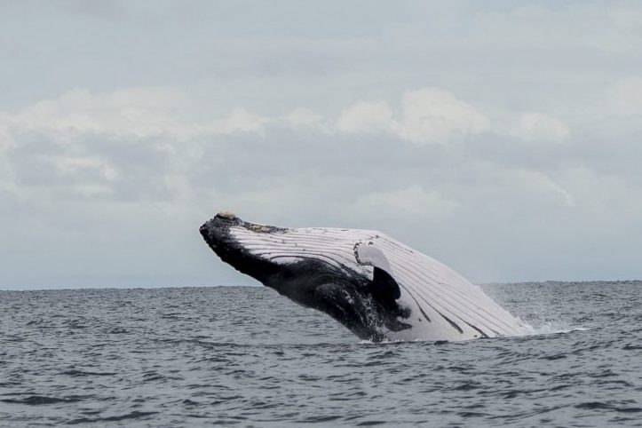
Humpback whales have robust bodies, large flippers, and many irregular fleshy knobs. They are almost entirely black, with some white spots.

You can distinguish its spout because it is an expanding column, somewhat balloon-shaped, which can reach up to 6 meters (20 feet) high! These marine mammals range from 13 to 16 meters (43 to 52 ft) and weigh around 30 metric tons.

One interesting trait about humpback whales is the songs produced by males, which last 10 to 20 minutes and are thought to be the longest continuous vocalizations of any mammal. 

During the migration season of whales in Colombia, you can be part of the lucky travelers that see them playing around and listen to their songs! 

Where to See Whales in Colombia 

Chocó, Cauca and Valle del Cauca are the best places to see whales in Colombia. These three departments cover most of the country’s Pacific coast and stand out for its warm climate and people. The food, in general, is also great.

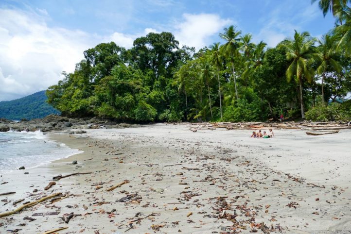
But the most amazing thing about these regions is the biodiversity they host since they belong to the Biogeographic Chocó with 2,750 of endemic plant species, moist, dry and montane forests, and a variety of wildlife. Bahía Solano, Nuquí, Gorgona island and Málaga Bay are favorite spots to watch whales in Colombia 

Bahía Solano 

Bahía Solano is one of the coastal municipalities of Choco, the one with most inhabitants (9,400). It is located in the northwest of Colombia, in the Serranía del Baudó. It acts as an economic and tourist center of the region.

The solaneños live from fishing and tourism, which has grown over the years with the increasing interest in nature and ecotourism. The megadiverse rainforest and sea are deeply cherished in the region. 

Our whale watching tour in Bahía Solano is an ecotourism experience, where you not only have fun seeing the whales’ acrobatics but you learn from a scientific perspective about these large mammals and the environment around you.

The tour also includes a stop to practice snorkeling and listen to the whales song underwater, and sail to the Mecana beach, where you can enjoy a natural pool of the river and wildlife observation. It is also possible to tour the mangrove in Mecana. 

How to get there 

  • By plane: There are daily flights from the cities of Medellín, Quibdó, Pereira, and Bogotá to José Celestino Mutis Airport in Bahía Solano. Flights take up to 2.5 hours. 
  • By boat: Some ships travel from the port of Buenaventura to the seaport in Bahía two times a week in a 6-hour ride. 

Accommodation 

There are a few hotels in Bahía Solano with medium to good quality. We can recommend these: 

  • Hotel Costa Chocó is in the town center and offers big rooms with air conditioning, balconies, pool, restaurant and a rooftop with view.  
  • Playa de Oro Lodge is a two-floor hotel in front of a golden beach in Punta Huina, which you can get to after a 20-minute boat ride from the Bahía Solano port. Although the rooms have no view, from the restaurant you can see the ocean. 
  • El Almejal Ecolodge is 40 minutes south of Bahía by road and is privileged to have a private nature reserve and the Utría NNP just 30 minutes away. The accommodation is in separate cabins. 

Other Attractions 

In Bahia Solano you can visit several waterfalls —such as Cascada del Amor and Nabugá—, beaches —Punta Huina, Playa de Los Deseos, Cuevitas, Mecana—, crystalline rivers and the Utría NNP.

At this rich park with mangroves, coral reefs, rocky littorals, and tropical rainforest, you can practice diving, snorkeling, hiking, bird, dolphin and turtle watching. 

Nuquí 

 Nuquí is a municipality south of Bahía Solano, also on the Pacific coast, with nearly 9,000 inhabitants. Most of them are Afro-Colombians, while others belong to indigenous communities.

Nuquí is another great destination for ecotourism and community-based tourism in Colombia, as it shares the Utría National Natural Park with Bahía Solano. 

Nuquí, Chocó

How to get there 

  • By air: You can fly from Bogotá, Medellín, Pereira and Quibdó to the Reyes Murillo Airport in Nuquí. Check Aexpa and Satena airlines, or Aeronuqui and Grupo San German travel agencies for charter flights. 
  • By boat: You can access Nuquí from Buenaventura or El Valle district in Bahía Solano. 

Accommodation 

These are some hotels where you can stay in Nuquí: 

  • Acuali is in front of the airport, with good,  airconditioned rooms. There are a restaurant and a cafe. They also include flights directly from Bogotá. 
  • La Joviseña is an ecolodge in Playa Guachalito, 45 minutes by boat from Nuquí. There is no electricity during the day, but the wooden cabins are well-equipped. They have a private boat. 
  • El Cantil is about 35 minutes by boat south from Nuquí, in front of the ocean with the jungle around. This eco-lodge offers 7 cabins, a hammock zone, a restaurant, and 2 terraces. 
  • EcoHotel Vientos de Yubarta is located on the beach of Nuquí and offers private transportation to the hotel as well as different nature tourism activities. 

Other Attractions 

There are scuba diving spots such as Piedra de Fidel, Parguera, Piedra Bonita and El Chuzudo. Surfers can visit beaches such as Playa Terquito, Pico de Loro, Pela Pela, El Chorro, Playa Brava, among others. Hot springs are also worth visiting, as the Joví and Coquí rivers. 

Gorgona Island 

Gorgona is a mysterious island on the Pacific ocean, within the department of Cauca, with dense tropical rainforest and rich coral reefs. Actually, it has been a national natural park since 1984 that includes the neighbor small island of Gorgonilla. 

It is a top nature tourism destination in Colombia because of its biological richness, to the point that it has gained the name of “Science Island” for all the information it has given researchers to understand the ecosystems and effectively manage the protected area.

This is a great spot for whale watching in ColombiaNot only you can see whales, but Gorgona also has 381 fish species, 11 whale and dolphin species, and 4 sea lion species. 

How to get there 

  • By plane: 4-hour connection flight from Bogota to Guapi. TAC and SATENA operators offer a daily round trip from Cali and Tumaco respectively. 
  • By boat: You can book a boat service from Guapi that will take you to the island in an hour and a half up to 2 hours. Otherwise, from the Buenaventura port, there are speedboat services that offer round trips for groups of over 10 people. 

Accommodation 

The licensed operator in the park offers accommodation for 2 to 7 people in cabins and an oceanfront house for groups up to 4 members. 

Other Attractions 

Explore the island through its 4 hiking trails that allow you to see the ruins of a maximum-security prison built in the 1960s, the ocean, and the species that inhabit the rainforest. During birdwatching tours, you can see frigate birds, pelicans and booby birds (Sula). There are several sites to practice snorkeling and scuba diving to see whale sharks, whitetip reef sharks, and coral reefs.  

Uramba Bahía Malaga 

 Uramba Bahía Málaga is a National Natural Park of 47,000 hectares located in Buenaventura, Valle del Cauca. This park belongs to a regional conservation corridor,  along with the Farallones de Cali NNP and Munchique NNP.

Because of its biodiversity, it is considered a world conservation hotspot. Rocky coasts, gray-ish beaches, blue sky, lush, pristine jungles surrounding emerald waters, mangroves and islets make up the landscape of the bay. 

This is another paradise for humpback whales in Colombia to breed their calves. Local tours for whale watching are offered here, guided by young locals. 

How to get there 

You can fly from Bogota to Buenaventura, or get to Cali –whether by plane or by road, and then drive about 2.5 hours to Buenaventura. There you have to take a boat for 1.5 hours to the Juanchaco pier,  where the tour boats await tourists. 

Accommodation 

You can look for hostels along the coast in nearby villages. 

Other Attractions 

Jump off the Sierpe waterfall and take a dip in the natural pools of Las Tres Marías, which flow into the sea. You can practice adventure sports such as kayaking, and more relaxed activities including hiking and birdwatching. 

Recommendations for Whale Watching in Colombia 

  1. Whales prefer to go out when the sea is calm and the sun, less intense, so it is more likely to spot whales during the first hours of the day or in the late evening. 
  2. These whale-watching destinations have warm, humid weather, with high level of rain. Dress accordingly for your tour: wear light clothes — preferably long sleeves, good shoes, and cap. Also, use coral-friendly sunscreen and insect repellent.
  3. Take binoculars with you, apart from a charged camera or cellphone to record the experience. 
  4. Beware that the boat you ride does not come too close to the whales since this can scare them or even set apart mothers from their calves. The minimum average distance is 200 meters. 
  5. Consider booking your tours with agencies working directly with local communities and respecting the environment.

We at Sula promote sustainable tourism, so we seek to contribute to the local economy and to raise awareness about caring for the megadiverse country that is Colombia. 

 Find more wildlife tours in the Colombia wildlife tours blog 

References 
About the author

Ana María Parra

Modern Languages professional with emphasis on business translation. Interested in cultural adaptation of written and audiovisual content.  Passionate about knowing new cultures and languages, tourism and sustainable living.

9 Destinations for Trekking and Mountaineering in Colombia  

Trekking and mountaineering in Colombia are becoming more popular among all tourists, not only backpackers. This is because these activities provide a different experience that allows people to connect with nature while discovering incredible places. Both require a good physical condition though, so think of this when planning an expedition!  

Colombia offers many trails for go trekking or mountaineering, from the world’s highest coastal mountain in the Caribbean coast to rock hills in the Amazon and some of the greatest snowy peaks in the imposing Andes mountain range that splits into 3 branches in Colombian ground. 

If you are an adventurous traveler, you need to know the diverse trails for trekking and mountaineering in Colombia. Here they are! 

1. The Lost City  

Lost City, or Teyuna, is the greatest archaeological finding in Colombia. This ancient indigenous civilization was built in the Sierra Nevada de Santa Marta, along the Buritaca river, by the Tayrona culture.

Over 200 stone structures including interconnected roads, stairs, terraces, canals, and ceremonial buildings are the remnants of the city, which was forcibly abandoned during the Spanish colonization. 

The round trip is 50 km long approximately and to enter, you must climb a 1,200 step stone stairway through the forest. This unique trek experience takes an average of 4 days but goes up to 6 depending on your physical level and stops done during the trip.

You will not only challenge your body but get to interact with Kogui local indigenous group and discover the immense biodiversity that inhabits this sanctuary. No need to say more, live the Lost City trek yourself! 

2. Tayrona National Natural Park  

The foothills of Sierra Nevada de Santa Marta merge into the intense blue-colored Caribbean sea, forming gorgeous white sanded beaches surrounded by mangroves and dense jungle with many endemic fauna and flora species. This is the breathtaking landscape you can appreciate in Tayrona. 

To get to the camping zone from the entrance, you need to take a 2-hour hike and there are other trekking trails:

  • The Kogui trail or Knowledge route from Cañaveral to Arrecife lasts 1 hour and has a low difficulty level.
  • The Arrecifes – Boca del Saco trail, also moderate and 2-hour long, in which you can pass by Playa Arrecifes, La Piscina and Cabo de San Juan del Guia. 
  • Another popular trek is Pueblito, something like the mini version of Lost City where Kogui families live. 

3. Los Nevados National Natural Park 

Los Nevados National Natural Park is in the Central mountain range of the Andes and comprises the three coldest thermal floors.

This means that here you can get to know Andean forest, paramo, and glacier ecosystems. 38 nearby municipalities and crop fields are provided with water thanks to the rivers that descend from the paramos and glaciers in the park. 

The snowy mountains that belong to this protected area are Ruiz, Tolima, Santa Isabel, and El Cisne, Quindio, and Santa Rosa paramillos, which form the greatest volcano complex in the country.

Many tourists visit this park to climb to the highest peaks of these mountains that go up to 5,300 meters above sea level!  

Currently, Nevado del Ruiz presents volcanic activity so access is restricted. Here are the two snowy mountains within the park you can climb to. 

4. Tolima and Santa Isabel Snow-capped Mountains

With its peak at 5,220 MASL, Nevado del Tolima is one of the two currently available options for mountaineering in Colombia.

The excursions take 4 days in total and usually start from Ibague or Salento. When you get to the summit, a view over Los Nevados Park and the Magdalena valley will take your breath away -on sunny days, of course.

This is one of the most demanding treks in Colombia because of its steep slopes and only experienced mountaineers should attempt to climb to the 2.8 km2 glacier.  

Located between the snowy volcanoes of Tolima and Ruiz, Santa Isabel is the lowest snowy mountain in Colombia.

Unlike others, it does not have a conic structure with a crater but a set of domes created by lava outpouring that allows the glacier thermal floor to existing. Poleka Kasue, as the Quimbaya indigenous culture called it, has its highest peak on the central summit at 4,968 meters above sea level.

Unfortunately, it suffered deglaciation in recent years, passing from 1.9 kmto 0.5 kmin 10 years. In fact, IDEAM studies have determined that it would take only a decade for this glacier to become extinct. 

The trip to Santa Isabel’s summit starts from Pereira, Santa Rosa de Cabal, or Manizales and takes 1 or 2 days to the summit.

Among the attractions of the trek is the viewpoint of Laguna del Otún and Paramillo del Quindío, and the gorgeous paramo landscapes that boast a frailejones valley and endemic flora and fauna species.

Once again, it is recommended to have experience in mountaineering and take all the safety precautions. 

5. Puracé National Natural Park 

Another Andean volcanic zone, this time declared a UNESCO Biosphere Reserve, this is Puracé NNP.

The Coconucos volcanic range has 11 volcanoes, among which Puracé is the only active one. The Magdalena, Cauca, Patía, and Caquetá rivers (some of the main rivers in Colombia) originate in this mountain, along with around 30 crystalline lagoons and several sulfur springs for hot baths.

It is located in the Cauca department and its name means “fire mountain” in the Quechua language, spoken by the homonymous indigenous culture that protects the territory. Puracé is a privileged spot for those looking for the majestic Andean condor, which soars over the paramo ecosystem. 

Departing early from Popayan, a road takes you to the park entrance, where you will find various trekking trails: one directly to the volcano and others with lower difficulty that pass by its beautiful water bodies and are 20 km long approximately. The landscape is stunning and the park is quite calm. 

6. El Cocuy National Natural Park  

Sierra Nevada of Güicán, El Cocuy, and Chita is the largest glacier mass in Colombia: within two mountain ranges it has over 20 snow peaks from 4,800 to 5,330 meters above sea level, Ritacuba Blanco being the highest.

It is located in the departments of Arauca and Boyacá and is sacred territory for the Uwa indigenous community, because of this there are some restricted areas.

This trek is particularly stunning cause you can find waterfalls, lagoons, important rivers such as the Magdalena or the Orinoco, frailejones, Andean condors, spectacled bears, and white-tailed deer! An unbelievable view. 

Mountain climbers of all levels visit the park to go trekking for 5 days usually, although now there are simpler trails for one-day hikes that start from El Cocuy municipality. However, it is better to be in good shape for any trekking trail, especially at such high altitudes. 

Notice: Since February 10th, 2020, El Cocuy NNP closed temporarily due to public order issues. Check its status on the web page before your trip. 

7. Chingaza National Natural Park

Chingaza páramo is a National Natural Park on the Eastern range of the Andes, between the departments of Cundinamarca and Meta.

Here you will face a cloudy environment hiding the blue sky, which reflects on the lakes surrounded by frailejones. Plus, it is possible to spot spectacled bears, deer, pumas, páramo tapirs, Andean condors, and Andean Cock-of-the-rock in the lower areas near Villavicencio.  

Trekking trips start from Guasca or La Calera municipalities and depending on the starting point, you will get to different lagoons. These water bodies were sacred to the former inhabitants, Muisca indigenous communities.

Among the most famous ones are the Siecha Lagoons, three small glacial lakes with high biodiversity around them. The maximum height you can reach is 3,800 meters above sea level and the route to the lagoons can be done in 1 day. This is an excellent option for practicing trekking near Bogota. 

8. Mavecure hills  

In the Guainia department, part of the Colombian Amazon region, three majestic rock hills rise from a pristine jungle by the Inirida river.

El Mono, El Pajarito, and Mavecure belong to the millenary Guiana Shield and can be reached by boat on a 3-hour trip from Puerto Inírida, the capital. Out of the three majestic black rounded hills, you can only climb Mavecure, which is 170 meters high.

Although it is not a really demanding hike that takes about an hour, the experience of sailing the river for hours and exploring a remote natural territory makes it a whole adventure. 

Take into account that this is a tropical zone and the weather here is hot, therefore you should be vaccinated against tetanus and yellow fever, also you should dress properly (long pants and rain boots) and keep with you a piece of basic safety equipment.   

9. Chicaque Natural Park 

Just 30 minutes away from Bogota, this eco-park covered by cloud forest offers several hiking trails for all adventurers. Although the routes individually do not take much time, there are over 20 km (12.5 miles) of hiking trails that you can complete in over 1 day, if you stay there, whether in camping zones, the hostel, cabins, or treehouses.  

After going into the forest, you can get to the Eagle’s peak, a viewpoint at 2,290 MASL from where you can see the Tequendama region and the snow-capped peaks of Los Nevados NNP on clear days.

Other trails are:

  • Roquedal, 667-meter long trail of high difficulty;
  • Butterflies, 1.6 km trail that leads to the hostel;
  • Oak Forest, 2.5 km trail surrounded by 30-meter oak trees;
  • Waterfall, 3.5 km long trail of high difficulty with a 70-meter high gorge; and the 
  • Colonial trail, 1.5 km long which was used by Muisca and Panche natives to connect the Bogota plateau with the Magdalena valley in the pre-Columbian era.

It is worth visiting Chicaque park on the outskirts of Colombia’s capital. 

These were 10 destinations to go trekking and mountaineering in Colombia in different regions of the country: the Caribbean coast, the Andes mountain range in the central region, and the Amazon jungle to the south.

From tropical to cloud forests, moorlands, and glaciers, trekking in Colombia is always a new adventure! 

If you want to know more about the most incredible natural destinations in Colombia, plan your trip with us!

References 
About the author.

Ana María Parra

Modern Languages professional with an emphasis on business translation. Interested in the cultural adaptation of written and audiovisual content.  Passionate about knowing new cultures and languages, tourism, and sustainable living.

Travel Guide to The Lost City Trek – Ciudad Perdida – in Colombia 

Ciudad Perdida, or Teyuna, is the greatest archaeological finding in Colombia. This ancient indigenous civilization was built in the Sierra Nevada de Santa Marta by the Tayrona peoples.

It is located on the northern face of the mountain, in the upper area of the Buritaca river basin at 900 – 1,200 meters above sea level. The site is reportedly 12,000 square meters, although only 3,000 m2 are open for tourists. 

Over 200 stone structures including interconnected roads, stairs, terraces, canals, and ceremonial buildings are the remnants of the city, which was forcibly abandoned during the Spanish colonization. 

What remained of the stone roads and buildings is now claimed as a sacred territory of the Kogui, Arhuaco, Wiwa, and Kankuamo indigenous communities and also is an archaeological park, part of the Sierra Nevada de Santa Marta National Natural Park. 

Lost City – Tayrona Park, Santa Marta

A look into the past of Ciudad Perdida 

The Lost City -English for Ciudad Perdida- received this name because it remained hidden in the forest until the 1970s, when the government realized its existence after rumors of hidden treasures in the Sierra spread out.

Colombia’s Ciudad Perdida has been compared to Machu Picchu, and it was actually built around 600 years before the world-famous Peruvian ruins. The Tayrona architecture highlighted the circle as the main infrastructural element.

The preference for the circulation around the villages also stands out and is reflected in the extensive network of roads, stairs and platforms that allow internal mobility in the settlement. 

A Place of Archeological Richness

Out of the 26 archaeological sites found in the river basin, the Lost City was the largest and most important of all, since it was assumed to be the political and cultural center of all the nearby settlements.

Archaeologists say that in the 16th century, Teyuna may have had between 1,500 and 2,000 inhabitants belonging to different political units with a language, architectural and cultural unity – the Tayrona culture. 

The Conquest Period

The 16th century, when the Spaniards arrived on the continent was quite intense and the civilization faced intermittent periods of conflict and peace when the indigenous and Spaniards held exchange relationships.

The latter was never able to dominate the Tayrona civilization nor settle in the Santa Marta range. However, several factors – such as conflicts and new diseases, progressively destabilized and decimated the population.  

The Indigenous People of the Sierra Nevada de Santa Marta

Today, the Kogi, Arhuaco, Wiwa, and Kankuamo indigenous peoples, inhabitants of the Sierra Nevada de Santa Marta, claim their right to this territory as descendants of the populations that inhabited it in the past.

These communities have learned to share their sacred land since the Teyuna Archaeological Park opened in 1980, but they demand respect for their traditions and territory. 

Biodiversity of the Lost City Trek 

The Sierra Nevada de Santa Marta is an important biodiversity reservoir due to its location in the Caribbean region of Colombia and the changes in elevation, known as thermal floors.

In Colombian mountains, every 1,000-meter increase in altitude means an estimated 3.5°F temperature decrease. This means that the higher you go, the cooler it gets, and also the ecosystems change. 

The Santa Marta range presents a variety of wildlife including 90 species of fish, 49 amphibians, 92 reptiles, 184 mammals, and 631 species of birds!

Birding at the Sierra Nevada de Santa Marta

This is a paradise for birders since 36% of the Colombian avifauna -and 7% of the world’s avifauna- is found here.

Santa Marta Brushfinch – Atlapetes melanocephalus

Find out more about birdwatching in the Sierra Nevada de Santa Marta in our entry Colombia’s Prime Birding Destination: Sierra Nevada de Santa Marta.

It has Important Areas for Bird Conservation (AICAS) in different zones of the park, where you can spot the Andean Condor, the Santa Marta Parakeet, and the Blue-billed Curassow.  

The Lost City Trek 

Local tour agencies offer treks of 4, 5, or 6 days to Ciudad Perdida. In Sula, we have a 4-day tour. The journey starts in Santa Marta, where Jeeps pick up tourists and take them to the starting point of the Lost City Trek, El Mamey, which is about 3 hours from the city.  

You will Arrive on Foot

The only way to get to Teyuna is on foot, so consider your fitness level if you plan to embark on this journey. The trek is about 50 km, you have to ascend and descend 4 small mountains… twice.

The daily hikes are at least 4 hours but can go up to 5 or 6 hours. Some quite steep stretches leave you exhausted but there is always time to rest. If you are physically trained, it will be OK; as long as you tolerate humidity. 

Sendero en la Ciudad Perdida. Photo: Baquianos, travel and Adventure

You will have to cross the Buritaca river many times, sometimes –when the water is high, with the help of a rope. At one point of the climb, there is also a type of improvised, hand-operated cable car that helps trekkers cross the river one by one.

When your guide warns you it is the last time you have to cross the river, it means that the Lost City is really close. What separates you from the ancient civilization? Only a quite steep 1,200 step stone stairway! 

Throughout the whole climb, you enjoy breathtaking views over the Caribbean sea and the tropical forest with exotic wildlife. But getting to the Lost City is another level of excitement.

Accommodation

There are several stops during the trek where you are offered snacks and hydration. The camps where you spend the nights offer really basic accommodation in cabins with bunk beds or hammocks.

You can carry your own hammock with a mosquito net and hang it if you prefer. These campsites are managed by local farmers or indigenous, and they offer you fresh food as well. 

The Experiences

After the challenging trek, you will feel rewarded with the landscape and the peaceful atmosphere. This is the point where your guide talks about how the Tayronas build their civilization and lived kind of isolated in the forest.

It is a fascinating story that encourages you to go explore the ruins and, of course, take tons of pictures as souvenirs. One good thing is that Ciudad Perdida is not a massive tourist destination, so you won’t have to deal with hundreds of people disturbing your calm or ruining your selfie. 

After this accomplishment, it is time to return. Two days of hiking and crossing the river again await you and your group. 

Lost City

Recommendations 

  1. Get yellow fever and tetanus vaccines at least 10 days before your trip to the Lost City. 
  2.  You need to wear one good pair of hiking shoes with good traction and waterproof if possible
    • The type of shoes you wear is crucial since the weather is warm and humid, and the rain is always a possibility.
  3.  Wear long pants and breathable long-sleeved shirts to protect yourself from mosquito bites -these abound, and sunburns. 
  4. Pack enough underwear and sets of clothes, since you will get wet, whether because of the sweat or a well-deserved dip in the river. 
  5.  If you have trouble sleeping in strange beds and in packed rooms, consider carrying your own hammock. 
  6. Take into account that you have to carry your luggage, so don’t overpack. 
  7. Be careful when drinking water in the camps, there have been people poisoned because of the questionable quality of water up there in the mountain. 
  8. Respect nature and the privacy of the indigenous peoples and farmers of the region.
  9. Don’t throw garbage away.
  10. Don’t take pictures of the communities or their belongings without their permission. 
  11. Contact a local agency with knowledge of the region, the trip, and the requirements.

We, in Sula, are happy to help you organize your Lost City trek! 

The trekking to Ciudad Perdida in Colombia is an unrivaled experience for your soul and body. No need to say more, live the Lost City trek yourself! 

References 
About the author

Ana María Parra

Modern Languages professional with an emphasis on business translation. Interested in the cultural adaptation of written and audiovisual content.  Passionate about knowing new cultures and languages, tourism, and sustainable living.