


What to Know When Hiking Santa Isabel and Tolima Snow-capped Mountains

Discover the Natural Wonders of the Snow-capped Volcanoes of Santa Isabel and Tolima, both famous destinations for hiking in Colombia. Find here useful information for your hiking trip to these two beautiful mountains in the Central Andes of Colombia.
The Andean Mountain Range
A large part of Colombia belongs to the so-called Andean highlands, consisting of the three Andean ranges which spread across a vast part of the territory.
Los Nevados National Natural Park is in the middle of one of these ranges, in what is known as the “Cordillera Central” or Central Andes (the middle range), splitting its territory through 4 departments named Tolima, Caldas, Risaralda, and Quindío.
At Los Nevados National Natural Park you will enjoy 6 volcanoes: Ruiz, Tolima, Santa Isabel, Cisne, Quindío and Paramillo de Santa Rosa.

Snow-capped Santa Isabel volcano
Santa Isabel volcano, also known as Poleka Kasue which translates “maiden of the mountain or princess of the snows”, was named after the ancient tribes of the area.
The Santa Isabel volcano is between the provinces of Risaralda, Tolima and Caldas, and sits in-between the other two snow-capped volcanoes: Ruiz and Tolima.
Santa Isabel is the lowest glaciated mountain in Colombia and one of the few equatorial glaciers in the world.
It consists of three main peaks:
- The Northern one at 4,964 meters above sea level,
- The Central one at 4,934 meters and
- The Southern peak at over 5,100 meters above sea level.
Hiking to the summit of Santa Isabel
Considering its moderate altitude it is not necessary to have experience in climbing snowy mountains. But it is important to take a day or two on a farm nearby the hiking trail to the summit to get used to the lack of oxygen and the weather.
For a better experience, 2 days of travel is highly recommended.
Day 1: Bogotá-Manizales-Base camp (Santa Rosa de Cabal)
Take a 40-minute flight from Bogota to La Nubia (MZL) airport in the city of Manizales. From Manizales, you must take a 1-hour road trip (bus trip) to Santa Rosa de Cabal where you will stay on a local farm.
Taking the earliest 06:00 am flight is deemed very convenient and will allow you to reach your destination at approx. 10:00.
Enjoy some typical breakfast, take a rest and immediately after begin your journey to the entrance of Los Nevados National Natural Park.
Arrival at Los Nevados National Natural Park
Upon arrival, expect a quick “things to care about” chat with officials from the National Park.
Please note that the entrance fee for non-resident foreigners is COP 64.500 (approx. 18 USD), and it includes a tour guide and medical insurance.
Otún Lagoon
The first stop, “Otún” Lagoon, located about 4,000 meters above sea level, will help you get an idea of the terrain and the conditions.
To get to Otún Lagoon first take a 3.5-kilometer hike to the base point where you will have a rest and some delicious lunch.
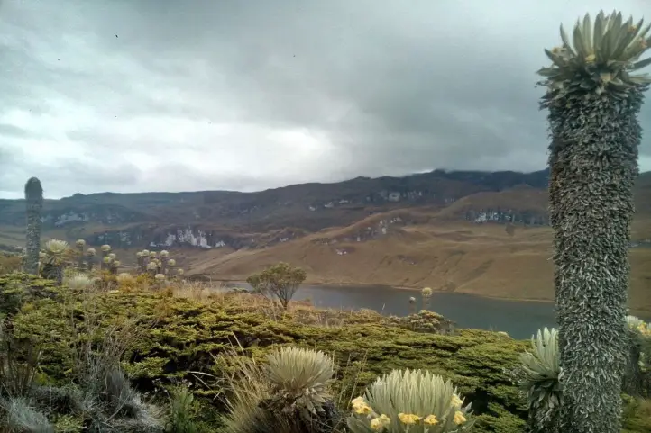
In the afternoon, the journey will resume heading to Otún Lagoon viewpoint for about 1 extra hour. Once there enjoy the view.
The return trip will commence before sunset all the way back to the farm.
Day 2: Base camp- Summit of Santa Isabel snow-capped volcano
The day starts at crazy early 1:30 a.m with some hot drinks and energy bars. A -transport will take you in 1 hour to the mountain rise at 4100 meters above sea level where your journey will begin.
The trail from this point leads to the glacier known as Las Conejeras (4700 meters above sea level) with a walking time of 3 hours.
During the hike be sure to enjoy the large variety of plants, including, the famous Frailejones, Spanish for “Big Monks”. These are some of the most important paramo plants and essential for the preservation of this type of ecosystem.
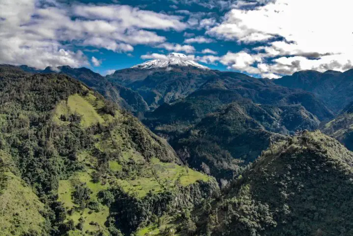
Moreover, lagoons and a beautiful panoramic view of the Nevado del Ruiz Volcano are also worth enjoying.
From Las Conejeras onward mountain-climbing equipment will be used to reach the top of the snow-capped volcano of Santa Isabel. This 2-hour hike across snowy trails allows everyone to appreciate an unforgettable 4964 m above sea level panoramic view.
1 hour at the peak is more than enough to appreciate the view and get some well-deserved rest. After that, head down to the base camp.
Snow-capped Tolima (Dulima) volcano
The Tolima Volcano is also known as Dulima which means “Emerged from the snows”, was named after the ancient local tribes inhabiting the area.
The natives considered that the spirit of the brave priestess and leader “cacica Dulima or Ibanasca” inhabits this snow-capped volcano.

The Tolima volcano is located in the province of Tolima, in the central mountain range of the Colombian Andes.
The Tolima snow-capped volcano is an attraction for those who wish to go beyond their limits due to its height (5,220 meters) and harsh climatic conditions. It has a glacier cap with an area of 2.8 km2 and a volume of 69 million cubic meters of ice.
Thus, those who wish to climb this snow-capped volcano must be experienced.
The Tolima Volcano is an important tourist attraction as a site for mountaineering and ice climbing, as well as for its thermal springs.
Hiking to the summit of Tolima
To visit the snow-capped volcano Tolima there are two routes, one of 4 days and the other of 3 days.
Option 1 (4 days)
Day 1: Bogotá-Armenia-Salento
Take a 1-hour flight from Bogota to El Eden International Airport (AXM) in the city of Armenia. From Armenia, you must travel by land to Salento for approximately 1 hour.
Once in Salento you can enjoy the rest of the day and visit famous sightseeing spots and the handicraft market of the town.
Day 2: Salento- Refuge
After breakfast in Salento, it is necessary to take a 30-minute “jeep” ride to the famous Cocora Valley. Next, start your hiking journey with an initial 4.5-kilometer hike crossing 6 rustic bridges.
The first stop is at 3100 meters above sea level refugee, from where it is possible to have lunch.
During this part, one can enjoy the flora and fauna of the Colombian Andean forests. Watch out especially for Andean tapirs, spectacled bears, pumas, sloths, Yellow-eared parrots, blue toucans, Andean guans, and Andean condors, among others.
The second 9 km hike starts after lunch through the middle of the unique ecosystem in the Andes mountain range: “the páramo”. The páramo is the ecosystem of the regions above the continuous forest line, yet below the permanent snowline.
Enjoy the large variety of plants, including, the famous Frailejones “Spanish for Big Monks”. One of the most important paramos plants, essential for the preservation of this type of ecosystem and considered an endemic species.
This hike ends at 3700 meters above sea level refugee site, where camp will be set up, and dinner and hot drinks served. Rest is highly recommended.
Day 3: Refuge- Base Camp
Revitalize yourself, enjoy breakfast, drink your coffee and get ready for a 9km mountain top hike, starting at the valley of the snow-capped mountain.
One hour away from the Refuge camp, you will first come across the beautiful Laguna del Encanto, 4,000 meters above sea-level wetland that gives rise to the Totare River that is on the way towards the Base where camping will be set up.
This 4,350 meters above sea level Base Camp is hit strongly by snowy winds that favor the view of the three additional beautiful snowy volcanoes, to wit: Nevado del Ruiz, Nevado Santa Isabel, and paramillo del Quindio.
At the Base Camp, additional preparation talk and rehearsal on the use of necessary mountain equipment will be given by the guides, in preparation for the next day’s hike to the top.
Please note that the entrance fee to Los Nevados Park is for non-resident foreigners is worth COP 64.500 (approx.18 USD), and includes guide and medical insurance.
Day 4: Base camp- Summit of Tolima snow-capped volcano
The final day starts at 1:30 a.m. with some hot drinks and energy bars.
Bear in mind to reach the top of the snow-capped volcano you must cross 3 different zones during a 9 kilometers hike:
- Arenales/morrenas (4,350 m-4,750 m): it has a steep slope and most of the way the terrain is sandy, its duration is 1 hour of walking.
- Rock zone/old Glacier (4,750 m-4,950 m): a 1-hour walk through rocks once covered by ice and now uncovered by the melted glacier. Note that the use of personal protection equipment (helmet, harness, and rope) is important for safety.
- Glacier/top (4,950 m-5,220 m): the last part of the scaling takes about 1.5 hours., temperature significantly drops, and difficulty in breathing might be experienced.
At the top, it’s good to relax, recover, enjoy the scenery before returning to the Base Camp for lunch.
The last part of the return trip down the mountain is riding a donkey back which helps speed up the journey.
Option 2 (3 days)
Day 1: Bogotá-Ibagué
Take 45 minutes flight from Bogota to Perales Airport (IBE) in the city of Ibagué where you can spend your afternoon and night going around the city.
Day 2: Ibagué-Base Camp
Early in the morning, a Jeep will take you to El Silencio at 2550 meters above sea level. From there, take a 1-hour hike to the thermal springs El Rancho and enjoy breakfast.
Next, you will face the steep hiking of Las Raices, known for its humidity and very dense flora.
The most representative flora visible on this route apart from the Espeletia hartwegiana, so-called Big Monks (frailejones) are the following species:
- The Loricaria colombiana, endemic plant of Colombia in the pussy’s-toes tribe within the sunflower family.
- The Polylepis sericea, another endemic of highlands.
- St. John’s wort of the genus Hypericum
- And the paramo rosemary of the genus Diplostephium.
Continue through the sector of Lajas until reaching Tierra de Gigantes. It is worth noting this is the last stop to refill drinking water.
Reaching 3700 meters above sea level you will come across La Cueva where you can enjoy a rest and have lunch.
The last part before reaching the 4,200 meters above sea level Base Camp is a moderately inclined hike of 2 hours. There you can camp and rest until the early hours of the morning.
Day 3: Base camp- Summit of Tolima snow-capped volcano
The day starts at 1:30 a.m. with some hot drinks and energy bars. Walkthrough las Latas until you glimpse the first snow-covered areas.
From this point on, it is necessary to use the personal protective elements (hull, harness, and rope) to make the last ascent to the top of the snowfall for approximately 45 minutes.
Lastly, go back down to the camp and get some well-deserved rest.
By taking these hikes you support sustainable tourism
During any of the hiking options you can support the following ventures:
- Energy bars @boli. bar. co, an enterprise of natural, tasty, and nutritious snacks, free of excess sugar.
- El Chalet del Cisne, eco-hotel has a panoramic view of the snow-capped peaks of Ruiz and Santa Isabel.
- The restaurants that you will find at each of the obligatory stops, each of the dishes served there are prepared by the inhabitants of the area.
Recommendations before hiking the snow-capped volcanoes of Santa Isabel and Tolima
- Enter only the authorized trails by Parques Nacionales, which are well kept, safe, and have guide services.
- Bring along convenient clothing since temperatures can significantly drop.
- Carry a suitcase of at least 30 liters, with a waterproof jacket and waist straps.
- Bring along basic protective elements such as cap, neck protector, flashlight, sunscreen, UV filter glasses, gloves, and boots with a high or medium cane.
- The entry and use of single-use plastics is prohibited by Sistema de Parques Nacionales Naturales.
- Carry enough snacks for the tour and make sure to store wraps in the available suitcase.
- Do not litter and help preserve the ecosystem
- Liquor or any toxic, psychoactive, or hallucinogenic substances are not allowed within the premises of the Parque Nacionales.
References
About the authors
Luisa Martin
Engineer, world traveler, amateur photographer, traveling blogger, and foody.


