The Treasure of “El Dorado”: The Guatavita Lagoon

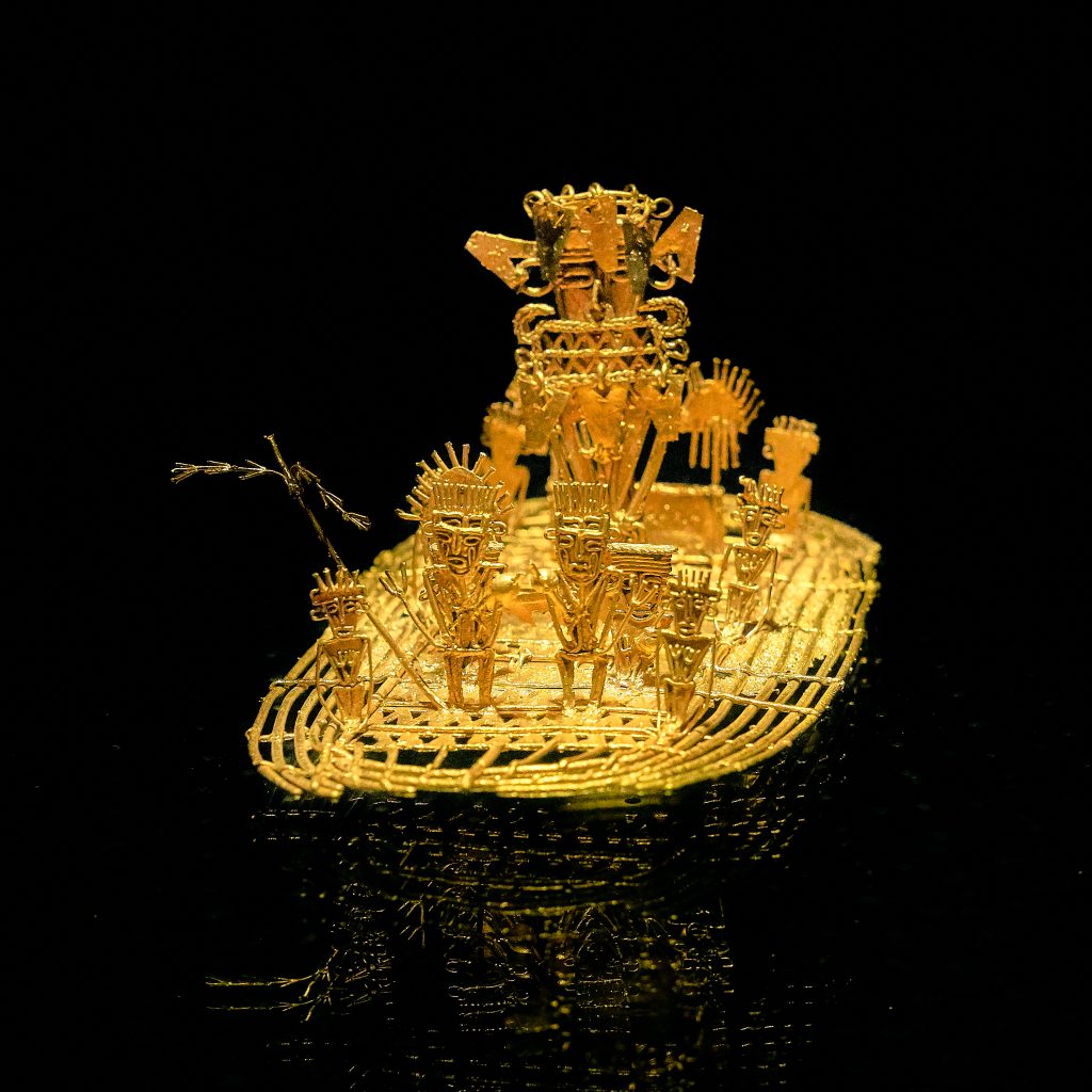
The Guatavita lagoon was one of the most sacred of the Muiscas, since the ritual of investiture of the new Zipa (Cacique- chief) was carried out there. This is one of the origins of the El Dorado Legend. The famous Muisca Raft that is exhibited in the Gold Museum of the Bank of the Republic of Colombia is evidence that this type of ritual was celebrated in the lakes of the region. Find out more about the museums of Colombia in The 117 Museums Guide of Colombia for Culture Travelers travel guide.

Guatavita comes from the Chibcha language GUA-TA-VITA, which translated into Spanish means “tillage of the tip” or “end of the mountain range”, as stated by the linguist Joaquín Acosta Ortegón in his Chibcha dictionary. The Chronicler Fray Pedro Simón, in his “Historical News”, said that Guatavita was called Guatafita, which means “thing set on high”, stating that it was the Spaniards who made the change from F to V to give it more phonetic sweetness to that name.


Origins of El Dorado Legend

According to the Muisca tradition, in Guatavita the cacique Sua was married to a beautiful princess from another tribe. Sua was very fond of chicha and bacchanals, and his wife, with whom he had a daughter, fell in love with a warrior who was courting her.

The lovers were caught by Sua, and he subjected the warrior to horrendous tortures, to the point of taking his heart out and serving it to his wife. The woman fled in despair, took her daughter in her arms and dove with her into the lagoon.

The cacique ordered the priests to recover his family. They informed him that the woman was now living under water, where a large snake had betrothed her. The cacique demanded that his daughter be brought to him, and they brought him a child without eyes. Sua, disheartened, returned her to the waters and ordered that from that day on, the best emeralds and gold filigrees be thrown into the lagoon (if you want to know about filigrees watch our video Santa Fe de Antioquia). The purpose of the ceremony was to beg the queen to ask the gods for prosperity and bonanza for her people.

Every full moon, Guatavita’s snake emerged from the waters to remind the people about the offerings, the priests watched his appearance as a sign of prosperity.

The Golden Indigenous

El Dorado Legend, gold statue at the Gold Museum, Bogotá, Colombia, picture by Pedro Szekely, from flickr, CC BY-SA 2.0. Wikimedia.

With the Spanish invasion, the ritual acquired a new meaning. They were told that a ritual was carried out when a new cacique, usually the nephew, son of a sister of the previous cacique, was in power.

The heir prepared himself within a six years period before the ceremony. He had to purified himself through fasting, and confined himself in a cave where he could not see the sun or eat food with salt or chili.

Some chroniclers have narrated it this way:

“…In that Guatavita lagoon, a great raft of reeds was made, decorated as brightly as possible… They undressed the successor, smeared him with a sticky soil and sprinkled him with gold powder and ground, so that in the raft everything was covered with this metal…

The golden indigenous man made his offering by pouring all the gold and emeralds he carried into the middle of the lagoon, and the four chiefs who went with him did the same. During the way back to land in the raft, they started a party, with bagpipes and “fotutos”, with dances in their own way, with which ceremony they received the new cacique who was recognized as lord and prince …”

From this ceremony was taken that so celebrated name of El Dorado.

The Search for the Treasure

The history of the “golden indigenous” gave rise to the “El Dorado”, a mythical place that the conquistadors sought from the Andes to the Amazon, with such eagerness that within a week, in 1539, three expeditions led by Sebastián de Belalcázar, Nicolás de Federmán ​and Gonzalo Jiménez de Quesada, from Peru, Venezuela and Santa Marta, respectively, coincided in Guatavita.

There were several attempts to drain the lagoon to find its hidden treasures, among which the most important were that of Captain Lázaro Fonte, who was able to extract several pieces of fine gold, and that of Antonio de Sepúlveda in the 16th century, who also managed to remove emeralds and ceramic pieces.

In 1580, a merchant named Juan Sepulveda employed 5,000 indigenous men and dug a canal to drain it. The water level dropped as much as 20 meters, but then the canal collapsed and the King of Spain refused to continue financing the enterprise. Sepulveda had to abandon, despite having rescued several pieces of filigree and an emerald the size of a fist.

Unsuccessful attempts continued throughout the colony, but the legendary gold continues to fuel treasure hunters’ dreams to this day. In an old German book published in 1911, for example, there is even a photograph, supposedly real, of the totally drained lagoon.

In the book is narrated that some W. Cooper, representative of the English company Contractors Limited, had shown two German tourists photographs of objects taken from the lagoon as rings, snakes, frogs and men’s heads, made of gold. This Cooper told them that the value of the gold found since 1909 amounted to at least 500 pounds, which paid several times the investment of the expedition.

Recovery of Guatavita Lagoon

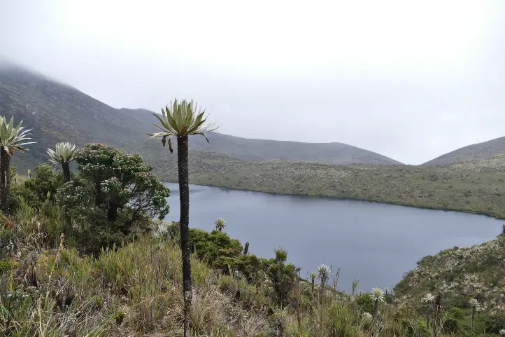
What is certain is that the Guatavita lagoon, when you visit it for the first time, is smaller than you could imagine… given the size of the legend!. But the sad thing is that this happened after it was emptied of more than half its contents by gold diggers, English and Germans, among others, until the end of the 19th century. These treasure hunters opened a hole in the mountain to drain the water to take out the gold pieces that rested at the bottom of the lagoon.

Fortunately, the failure of all these expeditions appeased the greed of the gold diggers. Initially, the place was reduced to abandonment, and at the beginning of the 21st century the park was closed to the public to try to recover it.

Today, a good part of its splendor has been reborn, with the frailejones, bromeliads, lichens, arnicas and multicolored mosses. The true treasure is the lagoon and the páramos of Colombia, because from there the water flows to all the surrounding regions.

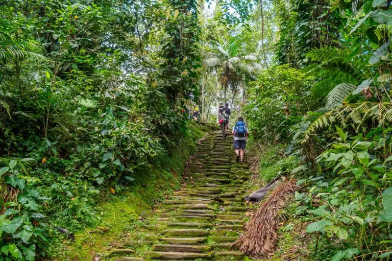
Currently, the lagoon is located in an environmentally protected area where you can access a trail that crosses an impressive mountainous area, full of vegetation and typical species of the Colombian páramo.

We recommend you to visit the Guatavita Lagoon after visiting the Golden Museum in Bogotá. 

How to Get to Guatavita Lagoon

Guatavita town is located 75 kilometers northeast of Bogotá, bordering the municipalities of Sesquilé and Machetá to the north; Gachetá and Junín to the east; Guasca and Sopó to the south; and Tocancipá and Gachancipá to the west.

However, Guatavita Lagoon is 8 km from the road that borders the Tominé reservoir, besides the town.

The Guatavita lagoon today is a Regional Natural Reserve of the System of Protected areas of Colombia. Entrance fee for foreigners is around of 13,000 COP (3.5 USD). After paying, you will be led by a local specialized guide, in small groups, through a natural path along the paramo.

Local guides are from the Muisca community which still inhabits the region.


Accomodation near Guatavita Lagoon

You can find accommodation in the town of Guatavita or in the nearby parks associated with the reservoir circuit that exist throughout the region. This accommodation, offered by the parks, is of the shared cabin type, with a minimum cost of 215,000 COP (60 USD), depending on the number of people.

Recommendations

To enjoy it to the fullest, we recommend you take comfortable, warm and waterproof clothing, as the average temperature of the place is 13ºC and rainfall is frequent. However, none of this will prevent you from having a deep connection with nature and with the ancestral past that this lagoon hides, and that makes it an authentic cultural heritage of the country.

If you want to know more about Colombian nature tours, or want to visit Guatavita Lagoon, follow us, write us comments, or just contact us.


References


About the author

Sara Colmenares

Current director of Sula. Doctor in Biological Sciences. Her main interests are to explore and understand the organism – environment interactions, taking advantage of emerging knowledge for the management and conservation of species and ecosystem services. She is currently working as a consultant in functional ecology, ecosystem services and conservation projects in Colombia related to ecotourism and birdwatching.

What to do at El Cocuy National Natural Park in Colombia

Precious glaciers, snow-capped peaks and paramo ecosystems are some of the jewels to find at El Cocuy National Natural Park in northeastern Colombia. Mountain climbers and nature lovers will love paying a visit to this huge mountain range that is a water producer and biodiversity haven. 

In this post, you will find all the information you need to know to visit El Cocuy National Natural Park in Colombia, such as how to get there, what you can do in the park, where to stay, how much it costs and some recommendations for your trip. 

Discovering El Cocuy National Natural Park 

Colombia has lost 63% of its glaciers in 50 yearsaccording to IDEAM. This means there will be no glaciers in the country in some years if the trend continues. Meanwhile, the Eastern Andes is the privileged home to the largest glacier mass in Colombia: The Sierra Nevada de Güicán, El Cocuy and Chita 

In an area of 25 km long by 4 km wide, about 25 snow-capped peaks stand out on the top of two mountain ranges! The peaks go from 4,800 m (15,748 ft) to 5,330 m (17,486 ft) above sea level, and the renowned ones are Ritacuba Blanco, Pan de AzúcarPulpito del Diablo, Cóncavos and Güicán. The temperatures in the park range between 0 °C (32 °F) and 20 °C (68 °F) with a characteristic cold climate. 

El Cocuy National Park preserves ecosystems such as glaciers and paramos, as well as high Andean forests – seen in the valleys among the imposing mountainsand moist forests found in the Araucan foothills. Unfortunately, the climate change, livestock breeding and forest clearance (logging) are putting pressure on the protected area.  

This marvelous park is guarded by the U’wa indigenous peoples. These have traditionally inhabited the Eastern Andes range and now fight for the conservation of their sacred territory and culture. Fun fact: U’wa means ‘smart people who know how to talk’. 

El Cocuy – with its 306,000 hectares, is one of the National Natural Parks open for ecotourism in Colombia. All of them offer unique experiences in the world’s second-most biodiverse country! 

How to get to El Cocuy NNP 

There are three land routes to access the tourist area on the western side of the park: 

From Bogotá 

440 km – approx. 11 hours following the route Tunja  Duitama – Santa Rosa  Cerinza  Belén – Susacón, until reaching Soatá. From there, you can follow the Tipacoque or the Boavita routes that lead to El Cocuy or Güicán 

From Bucaramanga  

8 to 12 hours. Get to the town of Málaga, then to Capitanejo  El Espino  Panqueba and finally El Cocuy or Güicán. 

From Llanos Orientales 

10 to 12 hours on the route Yopal  Sogamoso Duitama Belén  Soatá and from there, El Cocuy or Güicán. Or 8 hours on the route Tame, Sácama, Chita until El Cocuy. 

From El Cocuy and Güicán, it takes about 2 hours to get to the main entrances of the park on unpaved roads, in regular condition, suitable only for campers and 4×4 vehicles. You can get by a private car, a shared taxi or public trucks that leave from El Cocuy square every morning. The 3 access points are Valle de Lagunillas (on the south), Hacienda la Esperanza (at the center) and Ritakuwas (on the north). 

What to do in El Cocuy National Natural Park 

Hiking and Trekking  

Hiking is the most exciting activity in El Cocuy Park. You can hike only until the glacier edge along 3 trails: Ritacuba, Laguna Grande de la Sierra and Lagunillas – El Pulpito del Diablo. This activity allows you to admire majestic landscapes with Frailejones, imposing mountains and crystalline water bodies. 

  • Ritacuba Trail goes from the height of 4,000 m (13,123 ft) to the glacier edge of the peak called Ritacuba Blanco. The round trip is about 13.8 km. 
  • Lagunillas – El Pulpito Trail goes from 4,000 m (13,123 ft), starting just above the cabin Sisuma and ends in the glacier edge of the Pulpito del Diablo peak. 
  • Laguna Grande de la Sierra Trail starts in a place known as Cuchumba and ends in the glacier edge of the Cóncavo snow-capped peak. This is the longest and hardest trail (21 km/13 mi). 

Expert mountaineers can do rock and snow climbing as well as high mountain trekking. 

There used to be multi-day treks in El Cocuy, but negative environmental impacts caused by tourists and concerned indigenous inhabitants resulted in the closing of various hiking trails. Now you can only do one-day hikes. 

Lagoons 

At different points in the park, you can gaze at 25 stunning lagoons including Laguna de la Plaza – which drains in the shape of a waterfall, and Laguna Grande de los Verdes – which stands out for its flashy color. 

Wildlife observation

Along the trails, you may spot white-tailed deer, tapirs, the endemic lizard Stenocercus lache and the double-banded false coral snake (Erythrolamprus bizona)The cougar also inhabits the park but it is quite difficult to find. 

Birdwatching 

El Cocuy Park is an Important Bird and Biodiversity (IBA) which means it is a key spot for bird conservation. Some of the species that inhabit the area are the Andean condor, the endangered Northern Helmeted Curassow (Pauxi pauxi) and the hummingbird Shining sunbeam (Aglaeactis cupripennis). 

Where to stay in El Cocuy National Park 

Staying in El Cocuy NNP is not allowedHowever, you can find cabins managed by locals at the starting points of the hiking trails. They offer accommodation and meals. 

Best time to visit El Cocuy National Park 

The dry season occurs from December to late January, but this is also a peak season for national tourists so the park or the tourist services may be crowded. 

El Cocuy NNP Entrance fees 

The entrance fee to El Cocuy National Natural Park varies depending on the nationality and age of the visitors. These are the entrance fees for 2020: 

  • Colombians, resident foreigners and tourists from Bolivia, Ecuador and Peru (ages 5 to 25): COP 21,000 
  • Colombians, resident foreigners and tourists from Bolivia, Ecuador and Peru (over 25 years old): COP 36,000 
  • Non-resident foreigners (over 5 years old): COP 73,500 
  • Children under 5 years old and Colombians over 65 years old have free entrance presenting their IDs. 

What you should consider when you visit El Cocuy National Park 

  • You must purchase an all-risk policy for entering and staying in the park. 
  • You must make your reservation and payment one month in advance. 
  • You must register and attend the introductory talk at the registration offices in El Cocuy or Güicán before entering the park. Here you can hire your local guide.  
  • The entrance to the park is from 5:00 a.m. to 9:00 a.m. and return is from 1:00 p.m. to 6:00 p.m. No tourist should be in the park after 6 pm.  
  • Remember that the park is sacred territory for the U’wa indigenous. Therefore, visiting the eastern side of the park and entering the indigenous reserve is prohibited. 
  • Wear cold weather, waterproof clothes in layers (so you can peel off when necessary). This includes hiking boots or rubber boots since the trails can be muddy. 
  • Use sunscreen! Even if you think you don’t need it because it is cloudy. Also, a pair of sunglasses is advised. 
  • Bring enough water – at least 2 liters per person per day. 
  • Beware of altitude sickness! Apart from hydration, sun protection and proper clothing, you need to take your time and keep your rhythm during the ascent. Regular rests and arriving in a high-altitude town some days before the trek are advised too for acclimatization. If you feel bad, descend immediately. 
  • Due to physical demands and altitude, the hike is not recommended for people with physical disabilities, heart or respiratory problems. 

Some prohibitions: Feeding, bothering or hunting animals, throwing any garbage, pets, horses alcoholic drinks and drugs, gunsstepping on, sliding on or touching the snow, the entrance of children under the age of 10, people with physical disabilities, heart or respiratory problems, pregnant women or senior adults. 


References 

  • Album Jet Vive la Aventura Colombia – Parques Nacionales Naturales de Colombia, National Geographic, Compañía Nacional de Chocolates 
  • Natural National Parks

 About the authors.

Ana María Parra

Current content writer for Sula. Modern Languages professional with emphasis on business translation. Interested in cultural adaptation of written and audiovisual content.  Passionate about knowing new cultures and languages, tourism and sustainable living.

[/vc_column_text][/vc_column][/vc_row]

What you should consider when you visit Chingaza National Natural Park

All travelers staying in Bogota should devote a day or two to visit the great source of water” – Chingaza National Park. This huge park offers the most stunning views just a couple of hours from the capital of Colombia. The area is of great ecosystemic and cultural importance in the region and offers a great nature experience. 

In this post, you will find all the information you need to know to visit the Chingaza National Natural Park in Colombia, such as how to get there, what you can do in the park, where to stay, how much it costs and some recommendations for your trip. 

Discovering Chingaza National Park 

In the Eastern Cordillera, east of Bogota, an incredibly important ecosystem functions in a territory formerly worshipped by the Muisca indigenous. It is Chingazaa National Natural Park of 76,600 hectares that provides 80% of the drinking water of Bogota – the capital and largest city in Colombia. Amazing, right? This region is a water factory thanks to its paramos, Andean forests, lagoons, creeks and rivers, and is nicely embellished with unique Frailejones. 

The paramo ecosystem is native to the Andean mountains in Colombia, Ecuador, Venezuela, and Peru and extends from 3200 to 5000 MASL. “The paramos play a fundamental role in sustaining the lives of millions of people, providing essential ecosystem services such as water production for urban use, irrigation and hydropower generation. Paramos soils and vegetation provide efficient forms of carbon storage and sequestration” (IUCN, 2010). What makes Colombia so special is that it is home to most paramos in the world, including the largest paramo on earth Sumapaz! After this parenthesis, you should know that climate change and human activity are endangering the paramos. Livestock and agriculture – especially potato crops in nearby areas, are the main threats to the Chingaza páramo. 

In Chingaza, you will find over 60 lagoons of glacial origin that impress with their crystal-clear waters. You will feel lucky to drink such pure water! The largest and most important lagoon culturally is Chingaza lagoon, at 3250 m (10600 ft) ASL. The three Siecha lagoons are quite tourist-attractive too. Lagoons, mountains, and water were sacred worship sited for the Muiscas, where they made offerings. In their language, Chingaza means Serranía del Dios de la Noche (God of the Night Mountain Range). 

Chingaza is also a haven for native flora and fauna. The park covers areas up to 4000 m (13120 ft) ASL, so the animals and plants that inhabit these zones are capable of withstanding extreme conditions such as temperatures as low as 4°C (39°F) and constant rainfall. This means that the flora and fauna that you see here are endemic to this ecosystem. There are over 2000 plant species and around 390 bird species reported in Chingaza National Park. A number of mammals and frogs are found here too. 

How to get to Chingaza 

Chingaza is located a couple of hours from Bogota by car. There are 3 access points to Chingaza NNP: 

Guasca access: the Siecha control post is located 15 kilometers from the town of Guasca. You can only reach Lagunas de Siecha from this entrance. 

  • Private vehicle access: Route Guasca – La Trinidad rural settlement-San Francisco sector. After passing the Paso Hondo site, take the detour where you will find a signal indicating vehicle parking. From there, continue on foot for 1 kilometer until you reach the park cabin. No parking is available at the cabin. Vehicles are to remain on the road as indicated. This trip is recommended on a 4×4 vehicle. The distance between Guasca and the parking location is 14 kilometers. 
  • Public transportation access: Take a bus or taxi in Guasca to Paso Hondo, at La Trinidad rural settlement. The bus will drop you at Paso Hondo, from where you must continue on foot for 6 kilometers (1.5 hours) to the Siecha control post. Hikers are advised to be extra careful due to the transit of food-loaded trucks. 

La Calera access: La Calera urban center – Cemento Samper ruins – Buenos Aires rural settlement – Piedras Gordas control post (22 km from La Calera). Continue for 28 kilometers to the Monterredondo administrative center. Access through this sector is only possible by private vehicle. No public transportation access exists.  

  • Private vehicle accessRoute La Calera – Guasca. After 1 kilometer, take the detour on the right (passing the old Cemento Samper facilities-La Siberia), and then follow the road directions to the Chingaza Natural National Park. Although the road is not paved, it is in good conditionso cars, jeeps, and buses can drive here. 

Fomeque access: starting from the Fomeque urban center, continue for 26 kilometers, passing through the La Paila-Laguna de Chingaza control post, continue for 28 kilometers to the Monterredondo administrative center. 

  • Private vehicle access: Fomeque – La Paila control post. 26 km on the road to San Juanito, Meta. You should take this land access in a private 4x4 vehicle or hire one at Fomeque.  
  • Public transportation access: There is a route from Fomeque to San Juanito, Meta which passes by the La Paila control post on Mondays, Wednesdays, Thursdays and Saturdays. However, this route does not return the same day and there is no camping or accommodation available. 

What to do in Chingaza 

Hiking5 hiking trails currently exist: Lagunas de Siecha trail, Lagunas de Buitrago trail, Laguna Seca trail, Suasie trail, and Las Plantas del Camino – Laguna de Chingaza trail. The hikes along these trails let tourists admire the stunning cloudy landscapes with crystalline lagoons and a bunch of Frailejones while learning about the ecosystem, its importance and the cosmology of past inhabitants of the region including the MuiscasGuayupes and farmersThere are also 3 viewpoints: La Arboleda, La Ye (from where you can see the Chingaza lagoon) and Mirador de los Condores. 

Wildlife observation: In Chingaza, you can spot animals such as the white-tail deer (Odocoileus virginianus) – the largest species of deer in Colombia, which you will mostly find in pairs sneaking through the vegetation. Also, you can find the little red brocket, mountain paca, the endemic Pristimantis dorado frog and the puma. The main attraction of the park is the Andean bear, though. Also known as the Spectacled bear, the vulnerable species Tremarctos ornatos is actually difficult to spot because it is solitary and elusive. However, you can always trace it by tracks on the ground, scratches on trees, beds made of leaves and other signs. 

Flora observation: Among the 2000 species of plants in Chingaza, 5 are Frailejones. There is even an endemic species called Espeletia uribei, one of the tallest in the world since it reaches up to 18 meters. The Chingaza orchid (Telipogon falcatusis a small, beautiful epiphyte orchid, which means that it grows on the surface of a plant. 

Birdwatching: As mentioned above, around 390 species of birds have been recorded in Chingaza. Occasionally, on clear days, majestic Andean condors (Vultur gryphus) can be spotted soaring over the paramo from Mirador de los Cóndores. Other representative birds are the masked trogon (Trogon personatus) and the endemic Flame-winged parakeet (Pyrrhura calliptera). 

Where to stay in Chingaza 

You can make day trips to Chingaza, but there are two options for accommodation in case you want to spend an entire weekend away from the city. 

Camping: There is a camping zone in the Monterredondo sector equipped with parking, electric power, and bathrooms with drinking and hot water. 

Dorm in a cabin: Also, in the Monterredondo sector you will find a cabin managed by Corpochingaza, a community tourism organization in charge of the ecotourism services in the park. 

Entrance fees to Chingaza 

The entrance fee to Chingaza National Natural Park varies depending on the nationality and age of the visitors. These are the entrance fees for 2020: 

  • Colombians, resident foreigners and tourists from Bolivia, Ecuador and Peru (ages 5 to 25): COP 16,500 
  • Colombians, resident foreigners and tourists from Bolivia, Ecuador and Peru (over 25 years old): COP 20,000 
  • Non-resident foreigners (over 5 years old): COP 53,500 
  • Children under 5 years old and Colombians over 65 years old have free entrance. 

Additionally, depending on the vehicle you enter to the park in, you have a different fee: 

  • Car: COP 14,500  
  • Van (Colectivo): COP 37,000  
  • Bus: COP 78,000  
  • Motorcycle: COP 10,000 

What you should consider when you visit 

  • Visitors must purchase an all-risk policy for entering and staying in the protected area. 
  • You must file an entrance request at least 15 before your visit. 
  • The trip to Chingaza is only possible with a private car. If you don’t have one, contact a local tourism agency that organizes transportation for you. Having said that, the access roads are unpaved and care must be taken while driving. 
  • Plan a 2-day or 3-day trip to Chingaza if you want to hike several trails to explore more of the park. Distances are long and the weather is variable. 
  • Entrance hours are from 8:00 am to 12:30 pm. You must leave the park by 4:00 pm if you are not sleeping there. 
  • Only 40 people are allowed per trail, except for the short Suasie trail – which allows 80 people, and Lagunas de Siecha trail – with capacity for 60 people. 
  • If you are camping in the park, make sure the equipment is suitable for high mountain environments. 
  • Wear cold weather, waterproof clothes in layers (so you can peel off when necessary). This includes hiking boots or rubber boots since the trails can be very muddy. 
  • Use sunscreen! Even if you think you don’t need it because it is cloudy. Also, a pair of sunglasses doesn’t hurt. 
  • Don’t feed the deer and any other animal in the park! This is for their sake. 
  • Don’t throw any garbage or take your garbage with you. 

References 

  • Album Jet Vive la Aventura Colombia – Parques Nacionales Naturales de Colombia, National Geographic, Compañía Nacional de Chocolates 
  • National Parks Colombia
  • International Union for Conservation of Nature IUCN 

About the authors.

Ana María Parra

Current content writer for Sula. Modern Languages professional with emphasis on business translation. Interested in cultural adaptation of written and audiovisual content.  Passionate about knowing new cultures and languages, tourism and sustainable living.[/vc_column_text][/vc_column][/vc_row]

Best Time to Visit Tayrona Park to Avoid Crowds and Bad Weather

Tayrona is one of the most important, and probably the most famous, National Natural Park in Colombia. Most tourists coming to Colombia pay a visit to this park that boasts spectacular beaches apt for adventure sports and an unforgettable getaway. This is definitely a mustvisit destination on your Colombia holiday. 

In this post, you will find all the information you need to know to visit the amazing Tayrona Park in Colombia, such as how to get there, the best time to visit, what you can do there, and some recommendations. 

Discovering Tayrona Park 

Tayrona is a protected area of 150 square kilometers (58 sq mi) in northern Colombia with stunning landscapes and biodiversity. It comprises both the sea territory on the Caribbean Sea and the coasts that plunge into the wild jungle that hosts the highest coastal mountain on earth – the Sierra Nevada de Santa Marta.  

Flora and Fauna at Tayrona Park

In Tayrona, you can find several bays such as ChengueGayracaCintoNeguanje, Concha, Guachaquita, white-sanded beaches, and mangrove swamps around them, dry, rain and cloud forests, and marine ecosystems such as coastal lagoons, rocky shores, coral reefs, among others. 

In fact, the park has one of the best conserved dry forest in the country. The plant diversity is huge – species such as Ceiba or sandbox tree (Hura crepitans), Trupillo (Prosopis julliflora),  Aromo (Acacia tortuosa),  Brasil (Haematoxylon brasiletto)Caracolí (Anacardium excelsum)Higuerón (Ficus sp.) and avocado (Persea americana) grow in the park. 

Wildlife present in Tayrona Park is also worth mentioning. The place is a paradise for birders since 396 bird species can be spotted, from shorebirds to high mountain birds, among which are the Rufous-vented Chachalaca (Ortalis ruficauda), Blue-billed Curassow (Crax alberti), Sapphire-bellied Hummingbird (Lepidopyga lilliae), Brown-throated Parakeet (Eupsittula pertinax) just to mention some of the forest ecosystem. 

As for the mammals, 59 species are recorded, including the Grey-bellied night monkey (Aotus lemurinus)White-fronted capuchin monkey (Cebus albifrons), Howler monkey (Alouatta seniculus), sloth (Bradypus variegatus), armadillo (Dasypusnovemcinctus)Red brocket deer (Mazama americana), jaguar (Panthera onca), ocelote (Leopardus pardalis), anteater (Myrmecophaga tridactyla), as well as 40 species of bats and 5 marine mammal species. 

Reptiles include the Green, Loggerhead, Hawksbill, and Leatherback sea turtles, the iguana, the American crocodile, and the boa constrictor are found. 

Indigenous at Tayrona Park

Tayrona is outside the territory of indigenous reserves, so no indigenous communities live there. However, the 4 indigenous communities that inhabit the Sierra Nevada de Santa Marta (Kankuamo, Kogui, Wiwa, and Arhuaco) consider the coastal and lagoon zones within Tayrona as part of the sacred ancestral territory

This land must be respected as part of the cultural heritage of humanity and therefore protected by all visitors. Although a nature area shouldn’t be named an ancestral territory or a protected area for us to preserve it! Check other National Parks in Colombia open for ecotourism 

How to get to Tayrona Park 

Tayrona Park is 34 km (21 mi) from Santa Marta, in the Magdalena department, on the Colombian Caribbean coast. Access from the city is easy. If you haven’t organized a private transfer, you can take a taxi or a bus (usually leaves from the city’s market) and go on the Santa Marta – Riohacha route (called Troncal Caribe) for about 50 minutes. There are 3 entrances:  

El Zaino Entrance

El Zaino is the main entrance and allows you to access the following beaches in this order: CastilleteCañaveralArrecifeArenilla, La Piscina, Cabo San Juan, the Nudist Beach (Boca del Saco) and Playa Brava.  

Neguanje Entrance

If you plan a day trip and are not staying in the park, you can get to the Neguanje entrance (kilometer 5 on the same road to La Guajira), from where you can reach ChengueGayraca and Playa Cristal beaches.  

Calabazo Entrance

Last, 2 km before getting to the Zaino entrance is Calabazo. This is the entrance to reach the ruins of Pueblito, after a 3-hour hike. If you continue the hike, you get to Cabo San Juan and Playa Brava. 

By Boat from Taganga

Access to the park by boat is also possible. The boats leave from the village of Taganga, 5 km from Santa Marta, and take about 45 minutes to drop you in Cabo de San Juan area. 

Best time to visit Tayrona Park 

For quieter beaches and easily available accommodation, schedule your visit to Tayrona Park in September, October, and November. 

Like all tourist destinations in Colombia and the whole world, Tayrona Park gets really crowded during the peak seasons. Peak season in Colombia occurs from June to July and December to February.

Additionally, the holy week, 8 days, is held in March or April. It is better to avoid these moments and all holiday long weekends if you want to access relatively lonely beaches.

You should also check the Parques Nacionales webpage beforehand because the park closes for one month (usually January or February) every year.  

As for the weather, May, JulySeptember, and October are the rainiest months, but rain is occasional and does not greatly affect your plans, while the dry season may restrict bathing on some beaches.

What to do in Tayrona Park 

Lost City – Tayrona Park, Santa Marta

Beaches

In Tayrona, white sandy beaches with crystal waters surrounded by mangrove swamps and forests are the main attractions. The most visited ones are:

  • Cabo San Juan del Guia, which is beautiful and huge,
  • La Piscina (large shore and calm waves)
  • Arenilla (the small zone between Arrecife and La Piscina)
  • Cañaveral (where you find Ecohabs Tayrona, although you cannot swim in there),
  • La Piscinita (small zone next to Cañaveral apt for baths), and
  • Arrecifes (also not allowed to swimmers but with several campsites). 

Hiking

There are 4 hiking trails that go from low to high difficulty and from 1 to 4 hours. 

  • Kogui or Knowledge trail from Cañaveral to Arrecifes (low difficulty, one hour).  
  • Arrecifes Boca del Saco trail going through Arrecifes beach, the natural pool and Cabo San Juan del Guía (low difficulty, 2 hours).  
  • The stone road to Pueblito from Cabo San Juan del Guía (high difficulty, 3 hours).  
  • Calabazo – Pueblito – Cabo San Juan del Guía trail (high difficulty, 4 hours). 

Submarine fun

For those who are more adventurous, snorkeling and diving are available too. The areas for scuba diving are Isla Aguja and Granate, this activity is managed by the diving schools of the village of Taganga.

You can snorkel in Neguanje, in front of Playa del Muerto, or in the Tayrona natural pool. At Gayraca bay you can dive and snorkel. 

Birdwatching

As mentioned above, birdwatching in Tayrona Park is one of the best activities since there is huge diversity of avifauna. 

Fauna and Flora observation

Other animals that can be observed here are the howler monkey, cotton-top tamarin, deer, ocelot, and the jaguar, reptiles such as the blue poison dart frog, iguanas, and the American crocodile. Playful dolphins cheer lucky tourists too. Local flora includes evergreen trees, moss, bromeliads, and orchids. 

Pueblito

Other activities are observation of cultural and archaeological heritage in architecturally important areas. One of them is Pueblito, where you can find ruins of the Tayrona ancient indigenous civilization, after a hike that takes about 3 hours. Its stone structures such as terraces, paths, and stairs are well-conserved. 

Where to stay in Tayrona Park 

There are different types of accommodation in Tayrona Park for all tastes and budgets. 

Lodges 

  • Cañaveral sector: 14 ecohabs (eco-lodges), all for double accommodation, but 11 with an option for extra beds for up to 4 people in family accommodation. Designed like the traditional indigenous houses with views to the Cañaveral beach.  
  • Los Naranjos: ecohabs in Finca Barvolento, 2 minutes from Los Naranjos beach. 8 cabins with a private bathroom and terrace. There is also a private house on this beach, 5 minutes from the main entrance of the park.  
  • Arrecife: 2 independent cabins, each one for up to 5 hosts, in Arrecife beach. 

Camping zones 

Several beaches offer zones to set a tent or a hammock and spend the night under the starred sky. These are: 

  • Cabo San Juan offers public bathroom and a restaurant. A small station of the Colombian Civil Defense is located there. 
  • Playa Brava: a remote beach, 4 or 5 hours walking from Zaino o Calabozo, with public bathrooms, cabins, and a small restaurant. 
  • Arrecife: the best beach to camp, near the police and Civil Defense stations and with a great restaurant. The camping area doesn’t have views of the sea, though. 
  • Cañaveralarea without views of the sea, near La Piscinita. 
  • CastilletesFinca with large camping zones, public bathrooms, and a restaurant. Bathing in this stretch of sea is not allowed. You can get there directly by car. 
  • Bahia Concha: the camping zone is shaded by large trees and the sea is calm and crystalline. You can get there directly by car. 

Tayrona Park 2020 Entrance fees 

The entrance fee to Tayrona National Natural Park varies depending on the nationality and age of the visitors, as well as the season of the year. These are the entrance fees for 2020: 

Peak Season 

(15 June – 15 July, 15 December – 15 January, Holy Week and long weekends) 

  • Colombians, resident foreigners, and tourists from Bolivia, Ecuador, and Peru (ages 5 to 25): COP 20,000 
  • Colombians, resident foreigners, and tourists from Bolivia, Ecuador, and Peru (over 25 years old): COP 28,500 
  • Non-resident foreigners (over 5 years old): COP 63,500 

Low Season  

  • Colombians, resident foreigners, and tourists from Bolivia, Ecuador, and Peru (ages 5 to 25): COP 18,000 
  • Colombians, resident foreigners, and tourists from Bolivia, Ecuador, and Peru (over 25): COP 24,000 
  • Non-resident foreigners (over 5 years old): COP 53,500 
  • People born in Santa Marta (ages 5 to 25): COP 9,000 
  • People born in Santa Marta (over 25 years old): COP 12,000 
  • Children under 5 years old and Colombians over 65 years old have free entrance. 

 Additionally, depending on the vehicle you enter to the park in, you have a different fee: 

  • Car: COP 14,500  
  • Van: COP 37,000  
  • Bus: COP 78,000  
  • Motorcycle: COP 10,000 

What you should consider when you visit Tayrona Park 

  • Entry hours are from 8:00 am to 5:00 pm. 
  • The park has a daily capacity of 6,900 tourists, so make your reservations in advance. 
  • Having yellow fever and tetanus vaccines is recommended. 
  • Always carry your ID, it is required at the entrance. 
  • The introductory talk about environmental education is mandatory. 
  • The climate in the park and surrounding areas is tropical hot, with temperatures ranging from 27 to 35 °C (81 to 95 °F). Therefore, use light cotton clothes, preferably pants and long-sleeve shirts. Also, wear appropriate hiking shoes, waterresistant if possible. 
  • Bring a cap, sunglasses, sunscreen, insect repellent, and a lantern. 
  • Only swim in permitted areas. Bathing in the sea is allowed until 6 pm. 
  • Access to the indigenous sacred places is forbidden 
  • If you hire a guide, make sure they are certified and preferably local. 
  • Don’t bring any plastic bags, alcoholic drinks, instruments, and pets to the park, these are not allowed. Also don’t leave garbage (even organics) anywhere. 
  • #BreatheTayrona – During January/February, the Tayrona Park closes its doors for allowing the restoration of its ecosystems, by the request of the indigenous communities in the Sierra Nevada de Santa Marta. Check the status of the park before your trip. 
References 
About the authors

Ana María Parra

Current content writer for Sula. Modern Languages professional with an emphasis on business translation. Interested in the cultural adaptation of written and audiovisual content.  Passionate about knowing new cultures and languages, tourism, and sustainable living.

Ecotourism in Colombia: Birding, Whale Watching, Hiking and Safaris

Being a megadiverse country and having a system of protected natural areas has allowed Colombia to start ranking as a worldwide ecotourism destination. In fact, regarding destinations for ecotourism, Colombia has it all!

Savannas, deserts, mountains, moorlands, snowy peaks, mangroves, rivers, two oceans, the Amazon… Every place you can think of is full of biodiversity and, fortunately, communities that work each day to preserve the natural wealth of the country.  

What is Ecotourism?

To understand better what ecotourism is and what it’s not, you should know that it is a niche belonging to a larger market segment —nature tourism. Nature tourism comprises 3 niches, namely, ecotourism, adventure tourism, and rural tourism. 

Ecotourism is the type of travel that involves natural areas, the participation of local communities and the promotion of environmental awareness.

It is beneficial for the conservation of the natural destination, the well-being of the community and the tourists themselves since they get greater appreciation for nature and culture.

This is why the ecotourism sector is growing more and more around the world, especially in tropical countries like Colombia. 

The niche of ecotourism, in turn, covers the following activities: bird watching, whale watching, observation of fauna and flora in general, and interpretive trails.

As a complementary product to ecotourism, interacting with local cultures during your trip —aka, cultural tourism, is totally recommended. 

Best Ecotourism Destinations in Colombia 

Now that you understand better what ecotourism is and what its activities are, here are the best destinations for doing ecotourism in Colombia, one for each specialized segment. 

Birdwatching in Colombia 

Birdwatching is the activity of observing, listening, photographing and identifying birds in their habitat. Some have birdwatching as a hobby, while others devote their lives to it. 

Anyway, for amateurs and professional birders alike, birdwatching in Colombia feels like heaven. Over 1,900 bird species are found all around this country in really different environments, blended with native vegetation and exotic animals. This is why birding in Colombia is quite an experience. 

La Guajira

There is an ideal destination for ecotourism —particularly for birdwatching, in the northernmost department of Colombia: La Guajira. La Guajira is also the northernmost tip of South America, being surrounded by the Caribbean sea.

Arid plains, dry forests and only 2 isolated mountains make up the overall landscape of this region, mostly inhabited by ethnic groups such as the Wayuu, Arhuaco, Koguis and Wiwa, Afro-Colombians and Arabs.

Sunset at Cabo de la Vela

The governmental abandonment in the region is evident in the lack of utilities, health care, and education, however, the population is leading sustainable initiatives to help conserve their natural and cultural heritage and bring livelihood to the communities.  

Avitourism is one of these initiatives that you can witness yourself. The dry forest of the La Guajira peninsula is a haven for around 500 bird species, 25 of which are nearendemic or restricted to such dry ecosystem.

Picture from Audubon: “Wayuu indigenous students and teacher Alvaro Jaramillo are bird watching in La Guajira, Colombia this past June. The program teaches locals to become tour guides for travelers interested in spotting birds. Photo: Carlos Villalon”

There is a community organization, Birding Guajira, led by José Luis Puchaina Epiayumember of the Wayuu ethnicity and birdwatching guide specialized in La Guajira’s birds.

With the support and training of the Audubon Society and Calidris  —as part of The Northern Colombia Birding Trail project, members of the community organization lead birdwatching tours in Los Flamencos Fauna and Flora Sanctuary.

Vermilion Cardinal – Cardinalis phoeniceus

The Vermilion Cardinal (Cardinalis phoeniceus), the White-whiskered Tail and the Chestnut Piculet are the most representative birds you can find in the tropical dry forests. An aquatic tour through the Navío Quebrado coastal lagoon will be your opportunity to observe the American Flamingos (Phoenicopterus ruber), along with other +150 migratory bird species. 

Fauna and Flora Sanctuary Los Flamencos

But the experience is not over there. Full cultural immersion is also available to tourists. “Tardes de Ranchería” is the program that lets you know the Wayuu culture and share valuable time with its members.

Talks about their myths, legends, and traditions are given. Also, you can taste typical Wayuu dishes, discover their crafts and witness their traditional dance —La Yonna. For this dance, they usually wear red or bright dresses in homage to the Vermilion Cardinal. 

Finally, you have the chance to spend the night in a chinchorro hammock, in a traditional ranchería. 

 Watch our experience birding in La Guajira:


Learn more about birds in Colombia and where to find them in our Colombia Birdwatching Guide 

Whale watching in Colombia 

Whale watching is an event that not everyone is privileged to witness. Fortunately for all the Colombia travelers, you can see whales on the Pacific coasts of Colombia! Visit our entry Whale watching in Colombia

This is possible due to large groups of Humpback whales (Megaptera novaeangliae) migrating from Antarctica and Southern Chile during the winter to the warm waters of the northern Pacific Ocean to mate, give birth and raise its calves. 

Chocó: Bahía Solano

Our whale watching tour in the Chocó town of Bahía Solano is a meaningful ecotourism experience, where you not only have fun sailing the Pacific Ocean to see the whales jumping out of the sea but you learn from a scientific perspective about these large mammals, the diversity of the region and also get to know the local culture.

Whether you enjoy taking pictures or videos of the whales greeting the tourists, or just saving the memory in your mind, you will have an unforgettable time.

Also, you can hear the whales’ songs through a speaker that reproduces the sounds recorded by a hydrophone. Fun fact: since these songs can last 10-20 minutes, they are thought to be the longest continuous vocalizations of any mammal! 

Bahía Solano is an ecotourism destination par excellence. Its lush jungles next to the sea, its pristine beaches, its beautiful waterfalls, the wildlife it hosts, and the people that live there are a full package for nature travelers.

During our tour, we make a stop at the Mecana beach to have lunch at a local restaurant, take a dip in the river and tour the mangroves of the region while learning the importance of this ecosystem.

We work with local operators so that this activity represents the local communities an opportunity for development. 

Experience this adventure yourself! Tour 

Interpretive trails in Colombia 

The interpretive trails are paths designed in natural reserves such as national or ecological parks “to enable visitors to understand more clearly the messages of history, the environment, or a nearly forgotten culture” (American Trails Organization).

This is a work achieved with local interpreters and support signs placed along the trails. Local interpreters have a deep knowledge of the history and biodiversity of the area since they’ve grown there and have been taught about the importance of preserving the natural heritage. 

Chingaza National Natural Park

Chingaza National Natural Park is one of the 23 protected areas in Colombia open for ecotourism. It is a paramo located on the eastern Andes, covering municipalities of Cundinamarca and Meta and accessible from Bogotá.

Lakes of Chingaza National Natural Park

A variety of fauna and flora thrives in the high Andean and sub-Andean forest and moorland ecosystems of the park. This is not the only reason to visit Chingaza, though.

The area is known to have been an indigenous territory, the land of the Muisca and Guayupe indigenous tribes. The stories of these ancient settlers remain alive and give meaning to the 6 hiking trails that currently exist:

  • Lagunas de Siecha trail;
  • Cuchillas de Siecha trail;
  • Lagunas de Buitrago trail;
  • Laguna Seca y Verde trail; 
  • Suasie trail;
  • La Arboleda trail; and
  • Las Plantas del Camino trail.

The guided tours along these trails let tourists admire the stunning cloudy landscapes with crystalline lagoons and a bunch of Frailejones while learning about the ecosystem, its importance and the past inhabitants of the region that left a footprint.

Corpochingaza is the community organization that offers guidance and environmental interpretation services in Chingaza. 

Flora and Fauna Observation in Colombia 

Casanare is one excellent ecotourism destination for flora and fauna observation in eastern Colombia. Casanare is one of the departments of Los Llanos, a region covering the Orinoco river basin and characterized by vast savannas inhabited by many wild animals, marshlands, llaneros (Colombian cowboys), joropo music and breathtaking sunsets. 


Safari Llanero in Casanare

Here you can have the truly Safari Llanero experience, the adaptation of the African concept that seeks the observation and appreciation of the Neotropical fauna.

Traveling the wide plains of Casanare —whether in Jeeps, on horseback, on foot or even in light aircrafts, lets you see capybaras, white-tailed deer, spectacled caimans, giant anteaters, giant otters, ducks, howler monkeys, owls, armadillos, red-footed tortoise, foxes, wild pigs, iguanas, and even anacondas, jaguars and cougars —if you are lucky.

Safari in Casanare

Also birds such as the Orinoco goose, herons, the Double-striped Thick-knee, the Jabiru, owls, varieties of Ibis including the Scarlet Ibis, . As for the native flora, moriche palms (Mauritia flexuosastand out. There are several natural reserves in Los Llanos where you can live this adventure, uncover them here. 

The Safari takes place in the early morning since the animals are more active then. Thanks to this, you have the afternoon free to immerse yourself in a Llanero experience.

You can participate in traditional horse rides through the rich savanna, observe the tradition of herding cattle for living and musical shows where locals sing folklore songs to the rhythm of guitars, harps and maracas about love, women, horses and the biodiverse Llanos. This is the perfect ending for an ecotourism trip. 

Wild horses at Casanare

Hopefully this blog has cleared up your doubts about ecotourism, its products and some ecotourism destinations in Colombia. We are happy to help you plan your nature trip to Colombia. 

References 
About the authors

Ana María Parra

Current content writer for Sula. Modern Languages professional with emphasis on business translation. Interested in cultural adaptation of written and audiovisual content.  Passionate about knowing new cultures and languages, tourism and sustainable living.

Travel Guide to The Lost City Trek – Ciudad Perdida – in Colombia 

Ciudad Perdida, or Teyuna, is the greatest archaeological finding in Colombia. This ancient indigenous civilization was built in the Sierra Nevada de Santa Marta by the Tayrona peoples.

It is located on the northern face of the mountain, in the upper area of the Buritaca river basin at 900 – 1,200 meters above sea level. The site is reportedly 12,000 square meters, although only 3,000 m2 are open for tourists. 

Over 200 stone structures including interconnected roads, stairs, terraces, canals, and ceremonial buildings are the remnants of the city, which was forcibly abandoned during the Spanish colonization. 

What remained of the stone roads and buildings is now claimed as a sacred territory of the Kogui, Arhuaco, Wiwa, and Kankuamo indigenous communities and also is an archaeological park, part of the Sierra Nevada de Santa Marta National Natural Park. 

Lost City – Tayrona Park, Santa Marta

A look into the past of Ciudad Perdida 

The Lost City -English for Ciudad Perdida- received this name because it remained hidden in the forest until the 1970s, when the government realized its existence after rumors of hidden treasures in the Sierra spread out.

Colombia’s Ciudad Perdida has been compared to Machu Picchu, and it was actually built around 600 years before the world-famous Peruvian ruins. The Tayrona architecture highlighted the circle as the main infrastructural element.

The preference for the circulation around the villages also stands out and is reflected in the extensive network of roads, stairs and platforms that allow internal mobility in the settlement. 

A Place of Archeological Richness

Out of the 26 archaeological sites found in the river basin, the Lost City was the largest and most important of all, since it was assumed to be the political and cultural center of all the nearby settlements.

Archaeologists say that in the 16th century, Teyuna may have had between 1,500 and 2,000 inhabitants belonging to different political units with a language, architectural and cultural unity – the Tayrona culture. 

The Conquest Period

The 16th century, when the Spaniards arrived on the continent was quite intense and the civilization faced intermittent periods of conflict and peace when the indigenous and Spaniards held exchange relationships.

The latter was never able to dominate the Tayrona civilization nor settle in the Santa Marta range. However, several factors – such as conflicts and new diseases, progressively destabilized and decimated the population.  

The Indigenous People of the Sierra Nevada de Santa Marta

Today, the Kogi, Arhuaco, Wiwa, and Kankuamo indigenous peoples, inhabitants of the Sierra Nevada de Santa Marta, claim their right to this territory as descendants of the populations that inhabited it in the past.

These communities have learned to share their sacred land since the Teyuna Archaeological Park opened in 1980, but they demand respect for their traditions and territory. 

Biodiversity of the Lost City Trek 

The Sierra Nevada de Santa Marta is an important biodiversity reservoir due to its location in the Caribbean region of Colombia and the changes in elevation, known as thermal floors.

In Colombian mountains, every 1,000-meter increase in altitude means an estimated 3.5°F temperature decrease. This means that the higher you go, the cooler it gets, and also the ecosystems change. 

The Santa Marta range presents a variety of wildlife including 90 species of fish, 49 amphibians, 92 reptiles, 184 mammals, and 631 species of birds!

Birding at the Sierra Nevada de Santa Marta

This is a paradise for birders since 36% of the Colombian avifauna -and 7% of the world’s avifauna- is found here.

Santa Marta Brushfinch – Atlapetes melanocephalus

Find out more about birdwatching in the Sierra Nevada de Santa Marta in our entry Colombia’s Prime Birding Destination: Sierra Nevada de Santa Marta.

It has Important Areas for Bird Conservation (AICAS) in different zones of the park, where you can spot the Andean Condor, the Santa Marta Parakeet, and the Blue-billed Curassow.  

The Lost City Trek 

Local tour agencies offer treks of 4, 5, or 6 days to Ciudad Perdida. In Sula, we have a 4-day tour. The journey starts in Santa Marta, where Jeeps pick up tourists and take them to the starting point of the Lost City Trek, El Mamey, which is about 3 hours from the city.  

You will Arrive on Foot

The only way to get to Teyuna is on foot, so consider your fitness level if you plan to embark on this journey. The trek is about 50 km, you have to ascend and descend 4 small mountains… twice.

The daily hikes are at least 4 hours but can go up to 5 or 6 hours. Some quite steep stretches leave you exhausted but there is always time to rest. If you are physically trained, it will be OK; as long as you tolerate humidity. 

Sendero en la Ciudad Perdida. Photo: Baquianos, travel and Adventure

You will have to cross the Buritaca river many times, sometimes –when the water is high, with the help of a rope. At one point of the climb, there is also a type of improvised, hand-operated cable car that helps trekkers cross the river one by one.

When your guide warns you it is the last time you have to cross the river, it means that the Lost City is really close. What separates you from the ancient civilization? Only a quite steep 1,200 step stone stairway! 

Throughout the whole climb, you enjoy breathtaking views over the Caribbean sea and the tropical forest with exotic wildlife. But getting to the Lost City is another level of excitement.

Accommodation

There are several stops during the trek where you are offered snacks and hydration. The camps where you spend the nights offer really basic accommodation in cabins with bunk beds or hammocks.

You can carry your own hammock with a mosquito net and hang it if you prefer. These campsites are managed by local farmers or indigenous, and they offer you fresh food as well. 

The Experiences

After the challenging trek, you will feel rewarded with the landscape and the peaceful atmosphere. This is the point where your guide talks about how the Tayronas build their civilization and lived kind of isolated in the forest.

It is a fascinating story that encourages you to go explore the ruins and, of course, take tons of pictures as souvenirs. One good thing is that Ciudad Perdida is not a massive tourist destination, so you won’t have to deal with hundreds of people disturbing your calm or ruining your selfie. 

After this accomplishment, it is time to return. Two days of hiking and crossing the river again await you and your group. 

Lost City

Recommendations 

  1. Get yellow fever and tetanus vaccines at least 10 days before your trip to the Lost City. 
  2.  You need to wear one good pair of hiking shoes with good traction and waterproof if possible
    • The type of shoes you wear is crucial since the weather is warm and humid, and the rain is always a possibility.
  3.  Wear long pants and breathable long-sleeved shirts to protect yourself from mosquito bites -these abound, and sunburns. 
  4. Pack enough underwear and sets of clothes, since you will get wet, whether because of the sweat or a well-deserved dip in the river. 
  5.  If you have trouble sleeping in strange beds and in packed rooms, consider carrying your own hammock. 
  6. Take into account that you have to carry your luggage, so don’t overpack. 
  7. Be careful when drinking water in the camps, there have been people poisoned because of the questionable quality of water up there in the mountain. 
  8. Respect nature and the privacy of the indigenous peoples and farmers of the region.
  9. Don’t throw garbage away.
  10. Don’t take pictures of the communities or their belongings without their permission. 
  11. Contact a local agency with knowledge of the region, the trip, and the requirements.

We, in Sula, are happy to help you organize your Lost City trek! 

The trekking to Ciudad Perdida in Colombia is an unrivaled experience for your soul and body. No need to say more, live the Lost City trek yourself! 

References 
About the author

Ana María Parra

Modern Languages professional with an emphasis on business translation. Interested in the cultural adaptation of written and audiovisual content.  Passionate about knowing new cultures and languages, tourism, and sustainable living.