Ultimate Guide to Visit Guainía: Jungle, Rivers and Astounding Views

Two events have consolidated Guainía in the minds of travelers, the first, the signing of the peace agreement and the second, the launch of the Ciro Guerra’s film The Embrace of the Serpent (El Abrazo de la Serpiente), winner of multiple awards around the world.
Guainía
Guainía in the Yuri language means “Land of many waters”. Its capital is Inírida, and it is located in the east of the country. The temperature of the region oscillates between 25 and 30 degrees centigrade.
Most of its territory is made up of flat extensions, although there are some elevations, mainly the so-called tepuis, which are remnants of the Guiana shield, the oldest mountainous formation on the planet.
The most famous hills are the Mavecure, but there are others hills and mountains like the so-called Aracuari, Canapiari, Guasacavi, Mavicure, Pajarito, Rana, Salvaje, Sáquiras, Sardinas, and the mountains of Caranacoa and Naquén, with heights slightly above 500 meters above sea level.
In the past this was a region afflicted by armed conflict and violence, but this situation is now in the past and the community has found in tourism an opportunity for life.
Communication Routes and Transportation in Guainía
In the department of Guainía, the main communication route is the rivers, which are the road axes of access. Roads are scarce and only passable in the dry months.
It is also important the air transport. There are two airports located in Inírida and in the town of Barranco Minas.
Tourism in Guainía
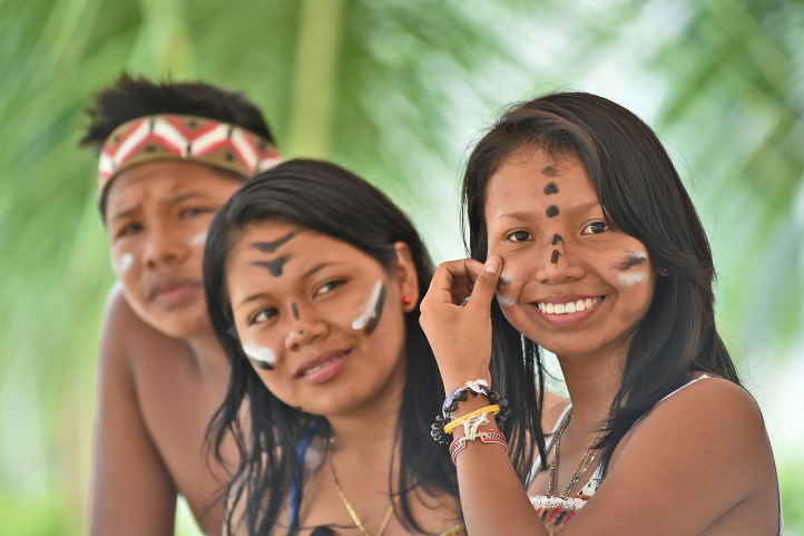
In Guainía one of the main attractions is its people, whose population is mostly composed of indigenous people (65%), who come from almost 30 different communities and belong to ethnic groups such as the puinave, curripaco, tukano, wanano, desano, piratapuyo, piapoco and yeral.

Other attractions are the Cerros de Mavecure, the Las Brujas lagoon, the Sapuara stream and the fluvial star. You can also find the Puinawai National Natural Reserve; the Pavón, Payara and Matevení Lakes, which together with the Inírida River, are destinations where you can practice water sports and sport fishing.
How to get to Guainía
You have to arrive by plane from Bogota to Puerto Inirida. The distance in straight line from Bogota is 720 Km, and it translates into 1 hour 10 min of flight.
It is recommended that you stay at least 4 days in the region to enjoy this majestic and sacred place.
In Inirida you can find several hotel offers, and all trips are made to and from the city by boat on the Inirida River and its tributary streams.
Below you will find the best destinations in Guainía.
Guainía Destinations
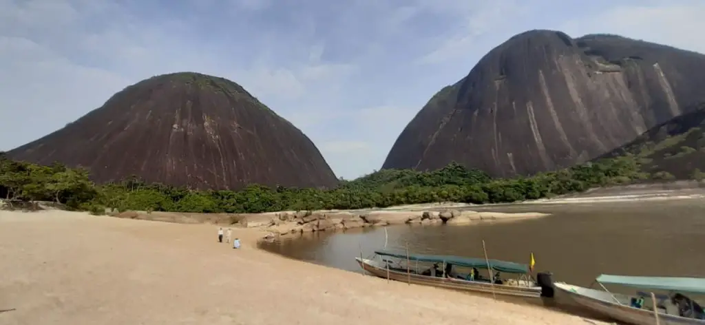
The Mavecure or Mavicure Hills
The Mavecure Hills are part of what we know today as deep Colombia. Embedded in the Amazon, they have become one of the most emblematic tourist destinations in Colombia.
In a study published about Ciro Guerra’s El Abrazo de la Serpiente, the Hills of Mavecure and surrounds are described as a landscape of enormousness, limitlessness, extraordinariness, and grandeur.

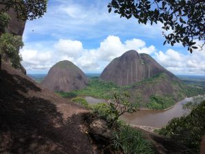
The hills of Mavicure are three hours away from Puerto Inírida, the capital of Guainía. There are three tepuis called Mavicure, Mono and Pajarito that serve as an impressive viewpoint to the Guainía’s jungles.
From the top of the hills you can appreciate large extensions of jungle inhabited by indigenous communities such as the Puinaves and Curripacos.
According to Puinave Tomás Corda Medina, a native of the Barranco Tigre community, in an interview for a national newspaper:
“in the curripaco language, Mavecure comes from the words ‘mavi’, which is a palm used to make different utensils, and from ‘cure’, a poison that the ancestors took from a tree and put on the tips of their arrows for hunting with blowpipes.”
It is said that the hills were considered a magical space where humans could communicate with their gods.
The hills of Mavecure are 55 kilometers west of this city. To reach them you must take a speedboat that takes about 2 hours to travel the 55 kilometers through the Inírida River.
Climbing the Mavecure Hills
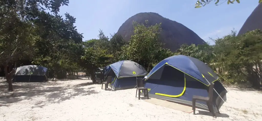
After arrival, you will have to spend the night in the El Remanso or in the El Venado indigenous communities placed at the foot of the hills.
You will need a guide to accompany you to the highest part of the hills, along the only trail suitable for walking and which does not require climbing equipment.
To reach the viewpoint, at 250 meters high, the only conditions are imposed by the weather and your physical condition. You must watch every step, and always go with a certified guide.
It is recommended to go up at a sunny moment. This is because, when it rains, the stone ground becomes slippery, and the slope makes the water run forming strong currents on the way down, which makes it very dangerous.
Once at the top you can see Pajarito and Mono; on their skirts you can see the dark green of a jungle that hides anteaters, water dogs, armadillos, limpets, chigüiros, tapirs, deer and tigers. In the distance, there are the caños that the river Inírida bathes, and other fluvial courses.


The activities that you can do in the Mavicure Hills are bird watching, hiking, photography, and nocturnal fish watching on the banks of the Inírida River where you can see rays, guaracus, palometas, agujones and cuchas.
Find more details about Mavecure in our entry 5 Things you Should Know Before Visiting the Mavecure Hills in Colombia.
Las Brujas Lagoon
The Laguna de Brujas or Chalchuapa (in the language of the natives) is defined by the locals as an oasis of peace. It is a quiet place where you can escape to feel the sounds of birds and nature in all its splendor.
Situated 10 minutes by boat from Puerto Inírida, you will feel overwhelmed by the beauty of the surrounding forest. Laguna de las Brujas is announced as the preferred habitat of the pink dolphins.
A variety of stories are told among the natives, such as the legend of the “Pink Dolphin” which tells that spiritual leaders arrived there to talk to the pink dolphins about the future of the Amazon and its communities.
Others say that it was named after a legend about some witches who stole the water from another place known as “Hoyos de la caldera” (boiler holes), but during the trip they dropped the water in the air, forming the Brujas Lagoon.
The truth is that, regardless of their origins, tourists and locals can take tours through this splendid landscape in canoes, accompanied by an indigenous guide.
Caño Bocón
It is the paradise of fishing. Bocón is one of the main tributaries to the Inírida River. It is bordered by jungle.
This river is located in the territory of the Puinave ethnic community, thanks to which the river, and its lagoons, with its Peacock Bass and the large Payaras that live in it, are cared for and watched over.
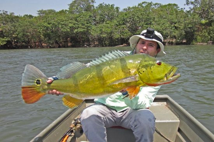
Thanks to an agreement with the Puinave, fishing is allowed for a maximum group of 10 people, you will not see anyone else in fishing action during your week.
The fishing is fast and abundant: Peacocks, Payaras, Catfish, Palometas, Bocones, Morocotos, etc.
Viejita Lagoon
Another paradise for fishing in Colombia. Downstream from Puerto Inírida, where the river delivers its waters to the Guaviare.
After two hours of navigation towards the east, you can leave the river and walk around 15 minutes through the jungle until you reach the Viejita lagoon.
On a floating raft you go around the lagoon completely. From the raft you will witness epic sunsets and landscapes.
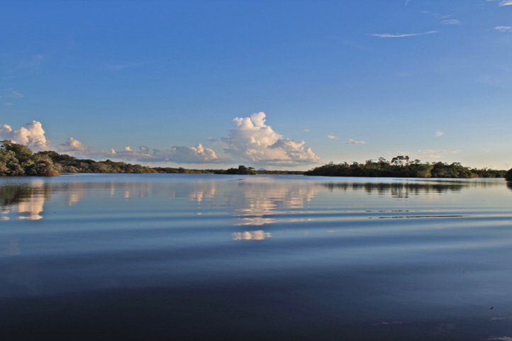
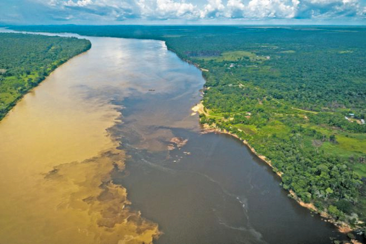
The Fluvial Star of Inírida (Estrella fluvial del Sur)
This is a must see in Colombia. This is a place where the rivers Guaviare, Atabapo and Inírida converge and swell the Orinoco River, one of the longest rivers in south American, and one of the top five largest rivers in the world.
Estrella fluvial del Sur, with its many rivers and lagoons, has been declared as a Ramsar Territory in 2014. This gave it recognition as a wetland of international importance, whose ecological and social value transcends the borders of a single country and benefits humanity.
The declaration of the Inírida River Star demand research efforts and substantial investments to safeguard the ecological integrity of the area. Ecotourism appears as a sustainable practice and activity compatible with the rational use promoted by the Ramsar Convention.
Estrella Fluvial del Sur Facts
- The River Star is home to 34% of Colombia’s wealth in freshwater fish species.
- Colombia has the second largest number of freshwater fish species in the world.
- The River Star is home to 70% of the known avifauna in Eastern Orinoco, 476 species of birds, two of which are exclusive to the place.
- In the Inírida River Star there are 903 species of plants, 200 of mammals and 40 of amphibians.
- The otter, the jaguar and the pink dolphin, present in the Fluvial Star, are in critical danger.
- In the area there are two indigenous peoples, Puinave and Curripaco, five resguardos and 15 communities that inhabit them, who support and legitimize the decision of the declaration as a Ramsar territory.
The Flower of the Inírida
It is an endemic plant of Guainía that grows in humid savannas and whose petals are red tips. Technically, the flower of the Inirida is two species of monocotyledonous herbs belonging to the family Rapateaceae. Both species are endemic to white-sanded savannas, with extremely poor, precarious soil conditions that are hostile to any plant.
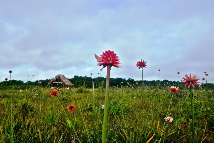
There are winter and summer ones and one is bigger than the other. The Winter Flower of Inírida (Guacamaya superba), the bigger one, blooms mainly during the rainy season in the region (June – October). On the other hand the Flower Summer of Inírida (Schoenocephalium teretifolium) blooms mainly during the season of drought (December – March).
Guainianos love and protect it and travelers admire it. It can be seen in all its magnificence in the savannahs on the way to Caño Bitina. During the flowering season, the savannah is dyed red because of the abundance of flowers.
Alto de Caño Mina
The Raudal Alto de Caño Mina, one of the tributaries of the Inírida River, is one of the most overwhelming in the Colombian Amazon.
This is one of the most emblematic destinations of this Secret Colombia. It has has a 15-meter waterfall of black, red and yellow waters. Its color is produced due to a great load of tannins it has.
It is necessary to go up the Inírida River for two days. Then you leave the Inírida River and enter through the Caño Mina.
Other Plans in Guainía
Ancestral writings (Coco Viejo Indigenous Community)
- Explanation of the ancestral writings by an interpreter of the Curripaco people and field trip where you will have contact with these writings.
- Know the petroglyphs.
- Typical gastronomy of the communities.
- Wooden handicrafts, natural fiber weaving, ceramics.
Visit ndigenous communities of Caño Vitina, Sabanitas, Guamal, Concordia.
- Experiential tourism.
- Ecological Tourism.
- Ecological Walk.
- Bird watching.
- Typical gastronomy of the communities.
- Wooden handicrafts, natural fiber weaving, ceramics.
Caño San Joaquín
- Sport Fishing.
- Ecological Tourism.
- Ecological Walk.
- Bird watching.
Raudales de Zamuro and Cualet
- Sport Fishing.
- Ecological Tourism.
- Ecological Walk.
- Bird watching.
- Experiential tourism.
- Typical gastronomy of the communities.
- Wooden handicrafts, natural fiber weaving, ceramics
Wildlife observation
- Toninas (pink dolphins) and bird watching.
- Visit the ornamental fish farms.
Water tourism and adventure
- Practice water ports such as skiing, diving and sport fishing.
- Camping or hammock nights.
Hiking and trekking
- Hiking through the forest to the indigenous community of Venado.
Recommendations
This is a trip to the jungle, so you have to be prepared for BASIC conditions of accommodation, food, transport etc. You will not find luxury things especially at night, because you will have to sleep in the community.
Additionally, take into account that the itinerary can vary according to the changes that the flights can have, the circumstances of the climate or unforeseen last minute.
Things you will need:
- Wear comfortable, light-colored and lightweight clothing, hopefully waterproof.
- Bring hats or caps for protection from the sun and wear a long-sleeved shirt.
- Wear hiking shoes, preferably waterproof, and extra tennis shoes.
- Photo or video camera to not lose any detail of these beautiful landscapes.
- Abundant hydration for the walks, sunscreen and repellent.
- A raincoat to cover yourself in case it rains.
- Small backpack for the daily walks.
- Flashlight.
- Sleepwear. It is recommended to take a light sleeping, at night it can be cold.
- Personal hygiene equipment in small quantities.
- Tape, micropore and anti-irritation creams.
- Camping equipment (tent, mattress) or hammock with ropes and tarp, depending on your preference for the first night.
- Swimwear.
If you want to know more about the most incredible natural destinations in Colombia, plan your trip with us!
References
- Mavicure: Tras el rastro de los cerros enigmáticos. Mundo Destinos. By: Fidel Cano Correa. © El Espectador.
- Guainía: intercambio cultural en un tesoro escondido. Mundo Destinos. By: Redacción Buen Viaje VIP. ©El Espectador.
- En busca de las montañas de los dioses. By: Nicolás Bustamante Hernández. Enviado Especial De Viajar. © 2016 EL TIEMPO Casa Editorial.
- Decolonial Encounters in Ciro Guerra’s El abrazo de la serpiente: Indigeneity, Coevalness and Intercultural Dialogue. By: Maria Chiara D’Argenio. University College London.
- Notas sobre la historia de la región de Chiribiquete. Revista Colombiana Amazonica Nº 10. 2017. ©SINCHI Institute.
- Estrella Fluvial del Inírida, declarada sitio Ramsar. MinAmbiente
About the author
Sara Colmenares
Current director of Sula. Doctor in Biological Sciences. Her main interests are to explore and understand the organism – environment interactions, taking advantage of emerging knowledge for the management and conservation of species and ecosystem services. She is currently working as a consultant in functional ecology, ecosystem services and conservation projects in Colombia related to ecotourism and birdwatching.